Documentation Revision Date: 2024-05-02
Dataset Version: 1
Summary
There are 12 data files in comma-separated values (.csv) format with this dataset. The dataset updates four sites with extended temporal coverage: Bonanza Creek (BNZ), Hess Creek Burned (HCB), Hess Creek Unburned (HCU), and Eight Mile Lake (EML).
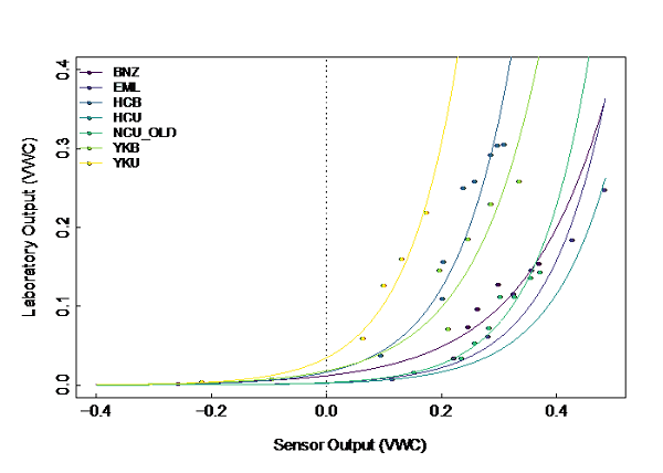
Figure 1. Site-specific soil moisture sensor calibration curves. Laboratory determined volumetric water content (VWC) is plotted against the raw VWC sensor output. Image courtesy of the authors.
Citation
Minions, C., S. Natali, J.D. Watts, and S. Ludwig. 2024. ABoVE: Soil Temperature and VWC at Unburned and Burned Sites Across Alaska, 2016-2023. ORNL DAAC, Oak Ridge, Tennessee, USA. https://doi.org/10.3334/ORNLDAAC/1869
Table of Contents
- Dataset Overview
- Data Characteristics
- Application and Derivation
- Quality Assessment
- Data Acquisition, Materials, and Methods
- Data Access
- References
- Dataset Revisions
Dataset Overview
This dataset provides soil temperature and volumetric water content (VWC) measurements at 15 cm depth collected at 12 selected boreal and tundra sites located across Alaska. Each site is equipped with a HOBO MicroStation Data Logger that hosts two soil temperature sensors (HOBO S-TMB-M006 Temperature Smart Sensor), and two soil moisture sensors (HOBO S-SMD-M005 10HS Soil Moisture Smart Sensor). Each sensor is installed horizontally at a depth of 15 cm within the soil profile. Samples of soil from seven sites were taken to a laboratory for the determination of site-specific soil moisture sensor calibration curves to correct raw measurements. Data were nominally recorded at an hourly frequency and downloaded from the sites at least annually for the period 2016-08-11 to 2023-09-02 but data coverage varies by site (Table 2). These measurements were collected at the same sites as previously archived CO2 efflux and thaw depth data.
Project: Arctic-Boreal Vulnerability Experiment
The Arctic-Boreal Vulnerability Experiment (ABoVE) is a NASA Terrestrial Ecology Program field campaign being conducted in Alaska and western Canada, for 8 to 10 years, starting in 2015. Research for ABoVE links field-based, process-level studies with geospatial data products derived from airborne and satellite sensors, providing a foundation for improving the analysis, and modeling capabilities needed to understand and predict ecosystem responses to, and societal implications of, climate change in the Arctic and Boreal regions.
Related Datasets
Minions, C., S. Natali, J.D. Watts, S. Ludwig, and D. Risk. 2019. ABoVE: Year-Round Soil CO2 Efflux in Alaskan Ecosystems, Version 2. ORNL DAAC, Oak Ridge, Tennessee, USA. https://doi.org/10.3334/ORNLDAAC/1762
Natali, S., S. Ludwig, C. Minions, and J.D. Watts. 2018. ABoVE: Thaw Depth at Selected Unburned and Burned Sites Across Alaska, 2016-2017. ORNL DAAC, Oak Ridge, Tennessee, USA. https://doi.org/10.3334/ORNLDAAC/1579
- CO2 efflux and thaw depth measurements were collected from the same sites included in these related datasets.
Acknowledgement
This study was funded with the NASA ABoVE program (grant NNX15AT81A).
Data Characteristics
Spatial Coverage: Alaska, USA
ABoVE Reference Locations
Domain: Core ABoVE
State/Territory: Alaska
Grid Cells: Ah01av0 Bh7bv5 Ch042cv32, Ah01av0 Bh6bv4 Ch40cv29, Ah01av0 Bh6bv5 Ch37cv34,
Ah01av0 Bh8bv3 Ch48cv21, Ah01av0 Bh6bv5 Ch39cv32
Spatial Resolution: multiple points
Temporal Coverage: 2016-08-11 to 2023-09-02 (see Table 2 for site-level dates)
Temporal Resolution: hourly
Study Area: Latitude and longitude are given in decimal degrees.
| Site | Westernmost Longitude | Easternmost Longitude | Northernmost Latitude | Southernmost Latitude |
| Alaska | -163.23868 | -146.55833 | 68.990798 | 61.27006 |
Data File Information
There are 12 data files in comma-separated value (*.csv) format.
The files are named Alaska_XXX_SoilTemp_VWC_15cm.csv, where XXX designates the site code as shown in Table 2.
Table 1. File names and descriptions.
| File Name | Description |
| Alaska_AKB_SoilTemp_VWC_15cm.csv | Soil temperature and soil moisture at 15 cm depth at the Anakutuvuk burned site. |
| Alaska_AKU_SoilTemp_VWC_15cm.csv | Soil temperature and soil moisture at 15 cm depth at the Anakutuvuk unburned site. |
| Alaska_BNZ_SoilTemp_VWC_15cm.csv | Soil temperature and soil moisture at 15 cm depth at the Bonanza Creek site. |
| Alaska_EML_SoilTemp_VWC_15cm.csv | Soil temperature and soil moisture at 15 cm depth at the Eight Mile Lake site. |
| Alaska_HCB_SoilTemp_VWC_15cm.csv | Soil temperature and soil moisture at 15 cm depth at the Hess Creek burned site. |
| Alaska_HCU_SoilTemp_VWC_15cm.csv | Soil temperature and soil moisture at 15 cm depth at the Hess Creek unburned site. |
| Alaska_IMH_SoilTemp_VWC_15cm.csv | Soil temperature and soil moisture at 15 cm depth at the I-MINUS high burned site. |
| Alaska_IML_SoilTemp_VWC_15cm.csv | Soil temperature and soil moisture at 15 cm depth at the I-MINUS low site. |
| Alaska_NCB_New_SoilTemp_VWC_15cm.csv | Soil temperature and soil moisture at 15 cm depth at the Nome Creek burned NEW site. |
| Alaska_NCU_Old_SoilTemp_VWC_15cm.csv | Soil temperature and soil moisture at 15 cm depth at the Nome Creek unburned OLD site. |
| Alaska_YKB_SoilTemp_VWC_15cm.csv | Soil temperature and soil moisture at 15 cm depth at the YK delta burned site. |
| Alaska_YKU_SoilTemp_VWC_15cm.csv | Soil temperature and soil moisture at 15 cm depth at the YK delta site. |
Data File Details
- Missing values are represented by -9999.
- Due to some technical issues, some sites are missing data for some of the listed variables.
- Data files for sites without Laboratory Calibration (see Table 2) do not have the 4 calibration-corrected variables (marked with * in Table 3).
- All sites have temperature filtered variables, i.e., values set to -9999 when rolling average temperature is -0.5 (see more details in the “Data Processing” section).
Table 2. Data availability at each site.
| Site | Data Start Date | Data End Date | Large Data Gaps | Laboratory Calibration |
| Anaktuvuk Burned (AKB) | 2017-06-23 | 2018-07-11 | NA | No calibration |
| Anaktuvuk Unburned (AKU) | 2017-06-23 | 2018-07-11 | NA | No calibration |
| Bonanza Creek (BNZ) | 2017-09-17 | 2022-10-13 | 2017-10-01 to 2018-07-06 * 2019-05-13 to 2021-05-23 * |
y = 0.0119e7.0563x |
| Eight Mile Lake (EML) | 2016-08-11 | 2023-04-04 | 2021-05-21 to 2021-07-30* | y = 0.0031e9.8444x |
| Hess Creek Burned (HCB) | 2016-08-22 | 2023-09-02 | NA | y = 0.0164e10.093x |
| Hess Creek Unburned (HCU) | 2016-08-22 | 2023-09-02 | 2017-02-13 to 2017-06-10 * 2021-05-02 to 2023-09-02** |
y = 0.0024e9.6963x |
| I-MINUS High (IMH) þ | 2016-08-21 | 2017-01-13 | NA | No calibration |
| I-MINUS Low (IML) þ | 2016-08-21 | 2017-06-22 | NA | No calibration |
| Nome Creek Burned NEW (NCB_New ) þ | 2017-09-21 | 2019-05-09 | NA | No calibration |
| Nome Creek Unburned OLD (NCU_Old ) þ | 2016-08-23 | 2017-06-13 | NA | y = 0.0032e10.681x |
| YK Delta Burned (YKB) | 2016-09-15 | 2019-07-02 | 2016-12-14 to 2017-07-08 * | y = 0.018e8.5244x |
| YK Delta Unburned (YKU) | 2016-09-15 | 2019-07-11 | 2017-05-14 to 2018-07-11 ** | y = 0.0348e10.912x |
þ Sites no longer collecting data.
* Indicate a gap in the entire dataset (data missing for all variables).
** Indicate a gap for select variables.
Table 3. Variables names and descriptions.
| Variable | Units | Description |
| latitude | degrees north | Latitude of site in decimal degrees |
| longitude | degrees east | Longitude of site in decimal degrees |
| start_time | YYYY-MM-DD hh:mm:ss | Date and time of measurement |
| soil_temp_15cm_01 | degrees C | Soil temperature at 15 cm depth from sensor 1 |
| soil_temp_15cm_02 | degrees C | Soil temperature at 15 cm depth from sensor 2 |
| vwc_15cm_raw_01 | 1 | Volumetric water content: raw sensor output from sensor 1 |
| vwc_15cm_raw_02 | 1 | Volumetric water content: raw sensor output from sensor 2 |
| vwc_15cm_cali_01 | 1 | Volumetric water content: corrected output using a lab-derived calibration curve for sensor 1. Value of 1.0 indicates saturated soil and value of 0.0 indicates dry soil. |
| vwc_15cm_cali_02 | 1 | Volumetric water content: corrected output using a lab-derived calibration curve for sensor 2. . |
| vwc_15cm_raw_filt_01 | 1 | Volumetric water content: raw sensor output with a temperature filtered applied for sensor 1 |
| vwc_15cm_raw_filt_02 | 1 | Volumetric water content: raw sensor output with a temperature filtered applied for sensor 2 |
| vwc_15cm_cali_filt_01 | 1 | Volumetric water content: calibration corrected sensor output with a temperature filtered applied for sensor 1 |
| vwc_15cm_cali_filt_02 | 1 | Volumetric water content: calibration corrected sensor output with a temperature filtered applied for sensor 2 |
Application and Derivation
These data could be useful to climate change studies.
Quality Assessment
Large blocks of soil were excavated from selected SRS sites to be used for soil sensor calibration in a controlled environment.
The data were examined and any ‘unnatural’ data points due to equipment malfunction or in some cases periods where a sensor had been removed from the soil, are removed from the dataset.
Data Acquisition, Materials, and Methods
Study Areas
Boreal and tundra sites are located across Alaska. Each site is equipped with a HOBO MicroStation Data Logger that hosts two soil temperature sensors (HOBO S-TMB-M006 Temperature Smart Sensor), and two soil moisture sensors (HOBO S-SMD-M005 10HS Soil Moisture Smart Sensor). Each sensor is installed horizontally at a depth of 15 cm within the soil profile. Data are collected at an hourly frequency.
Table 4. Site details.
| Site | Code | Latitude | Longitude | Description |
|---|---|---|---|---|
| Anaktuvuk burned site | AKB | 68.990797 | -150.2702 | The site is located near the Anaktuvuk river north of Toolik field station within the severely burned area of the 2007 Anaktuvuk river fire. The vegetation is characterized by moss and tussock tundra. |
| Anaktuvuk unburned site | AKU | 68.929906 | -150.2798 | The site is located in an undisturbed area near the Anaktuvuk river north of Toolik field station. The vegetation at the site is characterized by moss and tussock tundra. |
| Bonanza Creek site | BNZ | 64.695999 | -148.325677 | The site is located near the Bonanza Creek LTER Site, within a boreal black spruce stand. |
| Eight Mile Lake site | EML | 63.880123 | -149.256008 | The site is located off of the Stampede Trail in Healy. The area is characterized by moist tundra and sedge/shrub vegetation. |
| Hess Creek burned site | HCB | 65.568762 | -148.92344 | The site is located just off of the Dalton Highway between mile 11 and 12 within a burned boreal black spruce forest (1995). |
| Hess Creek unburned site | HCU | 65.567389 | -148.925157 | The site is located just off of the Dalton Highway between mile 11 and 12 within an unburned boreal black spruce forest. |
| I-MINUS high site | IMH | 68.557159 | -149.532908 | The site is located approximately 1 km off of the Dalton Highway, a few miles south of Toolik Field Station. The sensors are located on top of a hillside that is characterized by tussock tundra. |
| I-MINUS low site | IML | 68.5593 | -149.51605 | The site is located approximately 1 km off of the Dalton Highway, a few miles south of Toolik Field Station. The station is in a lowland, wet sedge fen area (Riparian). |
| Nome Creek burned site | NCB_NEW | 65.28603 | -146.55833 | The site is located less than 1 km off of the Steese Highway near mile 63. The sensors are located within a burned area (2004), and the vegetation is characterized by willow/herbaceous scrub. |
| Nome Creek unburned site | NCU_OLD | 65.285561 | -146.560019 | The site is located within the White Mountain Recreation Area, on a south-facing slope characterized by willow/herbaceous scrub vegetation. |
| YK Delta burned site | YKB | 61.27006 | -163.235788 | The site is located within the Yukon-Kuskokwim Delta area. The sensors are located within a burned area (2015), and the vegetation is characterized by wet sedge tundra. |
| YK Delta unburned site | YKU | 61.270857 | -163.238675 | The site is located within the Yukon-Kuskokwim Delta area. The vegetation is characterized by wet sedge tundra. |
þ Indicates that data are no longer being collected from the site.
Data Processing
The data are periodically downloaded and examined from each site (at least once per year). Any ‘unnatural’ data points due to equipment malfunction or in some cases periods where a sensor had been removed from the soil are removed.
Where there is a lab-derived calibration curve available, the raw sensor output from each soil moisture sensor is corrected using the corresponding equation (Table 5). After the calibration correction is applied any value greater than 1.0 is converted to 1.0 (saturated soil), and any value less than 0.0 is converted to 0.0 (dry soil).
A temperature filter is applied to both the raw and calibration corrected soil moisture data. Using the average temperature from both of the soil temperature probes, each soil moisture measurement is compared to the rolling average soil temperature. The rolling average soil temperature takes the average of the 12 temperature measurements before and after the soil moisture measurement in question. If the rolling average temperature is less than -0.5, the soil moisture measurement is replaced with -9999 (indicating a null value). The filter is applied to both the raw sensor output and the calibration corrected output.
Soil Moisture Calibration
Large blocks of soil were excavated from selected SRS sites to be used for soil sensor calibration in a controlled environment. All vascular vegetation were clipped from the surface of each soil block and soils were weighed (weights of each container were recorded and subtracted from final weights). Soils were saturated with water starting weights were recorded. A soil moisture sensor (HOBO S-SMB-M005 10HS Soil Moisture Smart Sensor) was fully inserted into the calibration soil at a depth of 15 cm to replicate the location within the soil profile of the sensor deployed at each field site. Soils were left to air dry until they appeared to be completely dry. Throughout this drying period, soils were periodically weighed with the weight and corresponding time recorded. Finally, soils were dried in an oven at a temperature of 60°C to remove all moisture. Sensor measurements were collected one last time for the dry soils. Using soil bulk density measurements obtained from other soil collections from each site, the volumetric water content for each calibration soil was calculated for each soil weight recording. The corresponding sensor output was plotted against the calculated volumetric water content value to generate a site-specific calibration curve (Figure 1; Table 5).
Table 5. Soil sensor calibration equations.
| Site Code | Calibration Equation |
|---|---|
| BNZ | y = 0.0119e7.0563x |
| EML | y = 0.0031e9.8444x |
| HCB | y = 0.0164e10.093x |
| HCU | y = 0.0024e9.6963x |
| NCU_OLD | y = 0.0032e10.681x |
| YKB | y = 0.018e8.5244x |
| YKU | y = 0.0348e10.912x |
Data Access
These data are available through the Oak Ridge National Laboratory (ORNL) Distributed Active Archive Center (DAAC).
ABoVE: Soil Temperature and VWC at Unburned and Burned Sites Across Alaska, 2016-2023
Contact for Data Center Access Information:
- E-mail: uso@daac.ornl.gov
- Telephone: +1 (865) 241-3952
References
None provided.
Dataset Revisions
| Release Date | Version | Revision Notes |
|---|---|---|
| 2024-05-02 | 1.0 |
Temporal extent expanded for BNZ, EML, HCB, and HCU sites. |
| 2023-10-31 | Temporal extent expanded for BNZ, EML, HCB, and HCU sites. | |
| 2021-08-27 | Original publication |