Documentation Revision Date: 2018-04-17
Data Set Version: 1
Summary
The data on sheep track sink depths and snow properties were collected at fresh sheep trails (< 48 hours old). Each sheep trail was considered a single track site from which a set of 4-10 individual, consecutive hoof prints were selected for measurement. A single snow pit was excavated adjacent to each track site, parallel to the track direction to measure snow density and assess the hardness and thickness of layers in the snow profile.
There are four data files with this dataset in comma-separated (.csv) format.
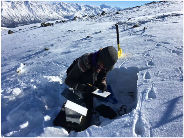
Figure 1. Measurement of snowpack characteristics and track sink depths at a Dall sheep (Ovis dalli dalli) track site in March 2017 on Jaeger Mesa, Wrangell St. Elias National Park and Preserve, Alaska (from Sivy et al., 2018).
Citation
Sivy, K.J., A.W. Nolin, C.L. Cosgrove, and L.R. Prugh. 2018. ABoVE: Dall Sheep Track Sinking Depths, Snow Depth, Hardness, and Density, 2017. ORNL DAAC, Oak Ridge, Tennessee, USA. https://doi.org/10.3334/ORNLDAAC/1583
Table of Contents
- Data Set Overview
- Data Characteristics
- Application and Derivation
- Quality Assessment
- Data Acquisition, Materials, and Methods
- Data Access
- References
Data Set Overview
Approximately 20% of the world’s Dall sheep population reside in the Wrangell Mountains of Alaska, yet populations have declined by 30% since the 1990s (National Park Service 2013). Jaeger Mesa is a remote alpine mesa at ~2,000 meters elevation, above treeline and characterized by alpine tundra and exposed, steep rocky slopes. A better understanding of environmental change in alpine systems and impacts on Dall sheep is needed to predict how sheep populations and harvest opportunities are changing throughout their range. To date, remote sensing capabilities are not able to provide snowpack characteristics at spatial and temporal scales needed for wildlife management applications.
This dataset contains Dall sheep (Ovis dalli dalli) hoof sinking depths in snow tracks, and snow depth, hardness, and density measurements in snow pits adjacent to the tracks. Snow measurements were collected between March 19-22, 2017 at sites on Jaeger Mesa in the Wrangell Mountains (WRST), Alaska. Estimated sheep age classes and track site coordinates are also provided. The measurements of sheep track sinking depths in snow and snow properties were collected at fresh sheep trails (< 48 hours old). Each sheep trail was considered a single track site from which a set of 4-10 individual, consecutive hoof prints were selected for measurement. A single snow pit was excavated adjacent to each track site, parallel to the track direction to measure snow density and assess the hardness and thickness of layers in the snow profile.
Project: Arctic-Boreal Vulnerability Experiment
The Arctic-Boreal Vulnerability Experiment (ABoVE) is a NASA Terrestrial Ecology Program field campaign based in Alaska and western Canada between 2016 and 2021. Research for ABoVE links field-based, process-level studies with geospatial data products derived from airborne and satellite sensors, providing a foundation for improving the analysis and modeling capabilities needed to understand and predict ecosystem responses and societal implications.
Related Publication:
Sivy, Kelly J., Anne W. Nolin, Christopher L. Cosgrove, and Laura R. Prugh. 2018. Critical snow density threshold for Dall sheep (Ovis dalli dalli), Canadian Journal of Zoology, https://doi.org/10.1139/cjz-2017-0259
Acknowledgements
This study was funded with NASA grant numbers NNX15AU21A and NNX15AV86A.
Data Characteristics
Spatial Coverage: Jaeger Mesa, Wrangell St Elias National Park and Preserve, Alaska
ABoVE Reference Locations:
Domain: Core ABoVE
Grid cells: Ah001v001Bh006v007Ch039v045
Spatial resolution: Multiple points
Temporal coverage: 2017-03-19 to 2017-03-22
Temporal resolution: Daily
Study Areas (All latitude and longitude given in decimal degrees)
| Site | Westernmost Longitude | Easternmost Longitude | Northernmost Latitude | Southernmost Latitude |
|---|---|---|---|---|
| Wrangell St Elias National Park, Alaska | -143.06001 | -143.00901 | 62.27908 | 62.25790 |
Data file information
There are four data files provided in comma-separated (.csv) format.
Table 1. File names and descriptions
| File name | Description |
|---|---|
| sheep_track_coords_depth_age.csv | This file provides the coordinates of the survey tracks as well as total snow depth and estimated age class of the sheep that made the tracks |
| sheep_track_depths.csv | This file provides data on track sink depth, width, and length |
| snow_density.csv | This file provides data on snow density of the snowpack |
| snow_hardness.csv | This file provides data on snow depth, hardness, and thickness of each snow layer from an excavated snow pit adjacent to each track site |
Variables in the data files
Table 2. Variables in the file sheep_track_coords_depth_age.csv
This file provides the coordinates of 45 survey sheep trail tracks as well as total snow depth and estimated age class of the sheep that made the tracks. Missing data (data not available or obtainable) are provided as -9999.
| Column name | Units/format | Description |
|---|---|---|
| track_survey_ID | Track ID number, 1-45 | |
| date | YYYY-MM-DD | Date in YYYY-MM-DD format |
| UTM_N | m | Northing coordinate of track site |
| UTN_E | m | Easting coordinate of track site |
| latitude | Decimal degrees | Latitude of track site |
| longitude | Decimal degrees | Longitude of track site |
| total_snow_depth | cm | Total snow depth |
| number_of_tracks | Number of tracks | |
| age | Estimated age class of the sheep that made the track- adult or lamb |
Table 3. Variables in the file sheep_track_depths.csv
This file provides data on track sink depth, width, and length. Missing data (data not available or obtainable) are provided as -9999.
| Column name | Units/format | Description |
|---|---|---|
| track_survey_ID | Track ID number, 1-44 | |
| track | Track number | |
| track_depth | cm | Track sink depth of each hoof print measured to the nearest half centimeter |
| depth_under | cm | Depth of snow under the track |
| track_width | cm | Track width |
| track_length | cm | Track length |
Table 4. Variables in the file snow_density.csv
This file provides data on snow density of the snowpack. The samples were obtained using a Snowmetrics 1000 cc stainless steel cutter. Each sample was weighed to provide a direct measure of snow density.
Missing data (data not available or obtainable) are provided as -9999.
| Column name | Units/format | Description |
|---|---|---|
| track_survey_ID | Track ID number, 1-45 | |
| density_top_10cm | kg/m3 | Snow density of the top 10-cm of the snowpack- 0-10 cm depth from snow surface |
| density_10_20cm | kg/m3 | Snow density (measured where possible) of the snowpack 10-20 cm depth from snow surface |
| density_20_30cm | kg/m3 | Snow density (measured where possible) of the snowpack 20-30 cm depth from snow surface |
| density_30_40cm | kg/m3 | Snow density (measured where possible) of the snowpack 30-40 cm depth from snow surface |
Table 5. Variables in the file snow_hardness.csv
This file provides data on snow depth, hardness, and thickness. A single snow pit was excavated adjacent to each track site, parallel to the track direction to measure snow density and assess the hardness and thickness of layers in the snow profile. Total snow depth of the snow pit face and thickness of each snow layer were measured to the nearest centimeter.
| Column name | Units/format | Description |
|---|---|---|
| track_survey_ID | Track ID number, 10-45 | |
| layer_number | Number of the snow layer in the pit. Layers numbered from the surface of snow to the ground. | |
| depth_top_layer | cm | Snow depth of the top of the respective layer as measured from the ground. |
| depth_bottom_layer | cm | Snow depth of the bottom of the respective layer as measured from the ground. |
| layer_thickness | cm | Snow layer thickness. |
| hand_hardness | Hardness of each snow layer in a snow pit determined using the hand-hardness method. The hand hardness values from softest to hardest were: fist (1), four fingers (2), one finger (3), blunt end of pencil (4), and knife blade (5). Average weighted hardness for each snow pit was calculated as the sum of thickness × hardness of layers in each pit, divided by the total snow depth | |
| category |
Subjective grouping of snow hardness indices as either "soft" or "hard". Index values of 1-3 were assigned as "soft", and index values 4-5 were assigned as "hard" |
|
| index | Snow hardness index from 1-5 |
Application and Derivation
Global climate change is driving changes in alpine vegetation and snowpack, and these changes interact with one another. Shrub encroachment reduces habitat area and connectivity and may bring predators closer to sheep. Changes in timing of alpine plant green-up and productivity affect lambing rates and body condition. Sheep rely on alpine meadows with shallow snow and may be severely impacted by deep snow, icing events, and late spring extent. A better understanding of environmental change in alpine systems and impacts on Dall sheep is needed to predict how sheep populations and harvest opportunities are changing throughout their range. This knowledge is critical for wildlife managers, hunters, and other stakeholders to effectively manage this iconic northern species. See Sivy et al., 2018.
Quality Assessment
Measures of standard deviation were used to analyze uncertainty in this dataset.
Data Acquisition, Materials, and Methods
Site description
Approximately 20% of the world’s Dall sheep population resides in WRST, yet populations have declined by 30% since the 1990s (National Park Service 2013). Jaeger Mesa is a remote alpine mesa at ~2,000 meters elevation, above tree line and characterized by alpine tundra and exposed, steep rocky slopes.The snowpack characteristics are consistent with “tundra” snow cover class: a generally thin (10-75 cm in depth), cold, wind-blown snowpack with depth hoar forming the base layer, multiple wind slabs,and patterned by surface sastrugi (Sturm et al., 1995). Average winter temperatures range from 20° to -5° C.
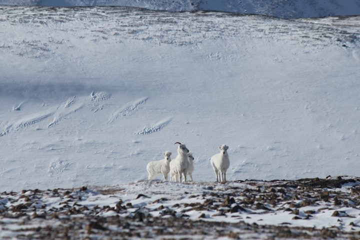
Figure 2. Dall sheep (Ovis dalli dalli) ewes and lambs near one of the sampling transects. Track sites were evaluated in March 2017 on Jaeger Mesa, Wrangell St. Elias National Park and Preserve, Alaska. (Source: Snow Surveys and Dall Sheep, May 9, 2017 by Laura Prugh, University of Washington, https://earthobservatory.nasa.gov/blogs/fromthefield/files/2017/05/IMG_8932.jpg)
Methods
Data on sheep track sink depths and snow properties were collected in March 2017 at fresh sheep trails (< 48 hours old) encountered while skiing/snowshoeing. Each sheep trail was considered a single track site from which a set of 4-10 individual consecutive hoof prints were selected for measurement. Each individual hoof print was thus considered a subsample from each track site. The criteria for selecting tracks was that they were on a consistent slope, did not penetrate through to bare ground, and were not obscured by windblown snow or stepped in by other sheep.
Sink depth and age estimation of sheep
Measurements were collected from 204 individual sheep tracks at 45 sheep trail track sites. At each track site the age class of the animal that created the trail was estimated by comparing the length and width of the hoof print to published lengths and widths of hoof prints for Dall sheep adults and lambs (Elbroch 2003). Hoof prints ≥ 4.5-cm wide and 5-cm long were classified as adults, and hoof prints < 4.5-cm wide and 5-cm long were classified as lambs. The sink depth of each hoof print was measured to the nearest half centimeter.
Snow depth, thickness, and hardness
Snow pit measurements were made at 35 sheep trail track sites. A single snow pit was excavated adjacent to the selected track site, parallel to the track direction to measure snow density and assess the hardness and thickness of layers in the snow profile. Snow pits between 1-2 meters wide were excavated to expose a shear vertical face extending from the snow surface to the ground. Brushes were used to expose and identify individual layers along the snow pit face, and craft sticks were used to mark the top and bottom of each recognizable layer.
Total snow depth of the snow pit face and thickness of each snow layer were measured to the nearest centimeter. Layers were numbered from the snow surface to the ground. Hardness of each layer was rated on a scale from one to five using the hand hardness test, a widely used field index for classifying snow hardness that corresponds to the amount of resistance experienced by an object pushed into the snow (Fierz et al., 2009; Höller and Fromm 2010). The hand hardness values from softest to hardest were: fist (1), four fingers (2), one finger (3), blunt end of pencil (4), and knife blade (5). For each layer, we multiplied the hardness rating (i.e., 1-5) by its layer thickness.
Snow density
Measurements were made at 45 sheep trail track sites.The snow density of the top 10-cm of the snowpack (i.e., 0-10 cm depth from snow surface; hereafter referred to as top horizon) was measured using a Snowmetrics 1000 cc stainless steel cutter inserted perpendicular to the snow pit face and level with the snow surface. Each sample was weighed using a digital scale (ACCULAB VI-4kg) to provide a direct measure of snow density. Where snow depths permitted, snow density of as many subsequent 10-cm horizons as possible were measured using the same procedure.
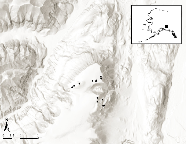
Figure 3. Study area showing locations of Dall sheep (Ovis dalli dalli) sheep track sites evaluated in March 2017 on Jaeger Mesa, Wrangell St. Elias National Park and Preserve, Alaska (from Sivy et al., 2018).
Data Access
These data are available through the Oak Ridge National Laboratory (ORNL) Distributed Active Archive Center (DAAC).
ABoVE: Dall Sheep Track Sinking Depths, Snow Depth, Hardness, and Density, 2017
Contact for Data Center Access Information:
- E-mail: uso@daac.ornl.gov
- Telephone: +1 (865) 241-3952
References
Elbroch, L.M. 2003. Mammal tracks and sign: a guide to North American species. Stackpole Books, Mechanicsburg, PA. https://doi.org/10.2193/0022-541X(2006)70[300:BRTSAG]2.0.CO;2
Fierz, C., Armstrong, R.L., Durand, Y., Etchevers, P., Greene, E., McClung, D.M., Nishimura, K., Satyawali, P.K. and Sokratov, S.A. 2009. The International Classification for Seasonal Snow on the Ground. IHP-VII Technical Documents in Hydrology N°83, IACS Contribution N°1, UNESCO-IHP, Paris. http://unesdoc.unesco.org/images/0018/001864/186462e.pdf
Höller, P., and Fromm, R. 2010. Quantification of the hand hardness test. Ann. Glaciol. 51(54): 39-44. https://doi.org/10.3189/172756410791386454
Sivy, Kelly J., Anne W. Nolin, Christopher L. Cosgrove, and Laura R. Prugh. 2018. Critical snow density threshold for Dall sheep (Ovis dalli dalli), Canadian Journal of Zoology, https://doi.org/10.1139/cjz-2017-0259
Sturm, M., Holmgren, J., and Liston, G. 1995. A seasonal snow cover classification system for local to global applications. J. Clim. 8(5): 1261-1283. https://doi.org/10.1175/1520-0442(1995)008<1261:ASSCCS>2.0.CO;2