Documentation Revision Date: 2022-02-23
Dataset Version: 1.1
Summary
The spatial domain was intended to match the MODIS Alaska Snow Metrics (Lindsay et al., 2015) and extend its temporal fidelity beyond the MODIS era.
There are 32 total files in GeoTIFF (.tif) format, one file for every year from 1988-2018 and a fractional water mask file (applies to the 1988-2016 data only).
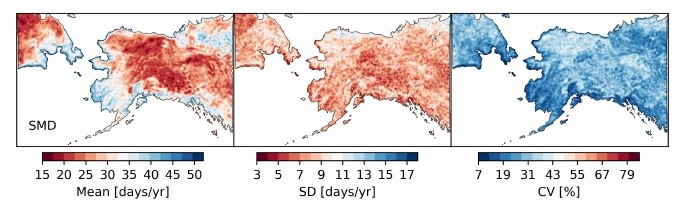
Figure 1. Descriptive statistics for snow melt duration (SMD) for the period 1988-2016, including mean, standard deviation, and coefficient of variation. Units are the number of days per year. Figure courtesy of dataset authors.
Citation
Pan, C.G., P.B. Kirchner, J.S. Kimball, and J. Du. 2021. ABoVE: Passive Microwave-derived Annual Snow Melt Duration Date Maps, 1988-2018. ORNL DAAC, Oak Ridge, Tennessee, USA. https://doi.org/10.3334/ORNLDAAC/1843
Table of Contents
- Dataset Overview
- Data Characteristics
- Application and Derivation
- Quality Assessment
- Data Acquisition, Materials, and Methods
- Data Access
- References
- Dataset Revisions
Dataset Overview
This dataset provides the annual period of snowpack melting (i.e., snow melt duration, SMD) across northwest Canada; Alaska, U.S.; and parts of far eastern Russia at 6.25 km resolution for the period 1988–2018. SMD is the number of days between the main melt onset date (MMOD) and the last day of seasonal snow cover when the melting of snow is complete. These dates were derived from the Making Earth Science Data Records for Use in Research Environments (MEaSUREs) Calibrated Enhanced-Resolution Passive Microwave (PMW) EASE-Grid Brightness Temperature (Tb) Earth System Data Record (ESDR). This dataset documents variability in SMD across space and the 29-year temporal period.
The spatial domain was intended to match the MODIS Alaska Snow Metrics (Lindsay et al., 2015) and extend its temporal fidelity beyond the MODIS era.
Project: Arctic-Boreal Vulnerability Experiment
The Arctic-Boreal Vulnerability Experiment (ABoVE) is a NASA Terrestrial Ecology Program field campaign being conducted in Alaska and western Canada, for 8 to 10 years, starting in 2015. Research for ABoVE links field-based, process-level studies with geospatial data products derived from airborne and satellite sensors, providing a foundation for improving the analysis, and modeling capabilities needed to understand and predict ecosystem responses to, and societal implications of, climate change in the Arctic and Boreal regions.
Related Publications
Pan, C.G., P.B. Kirchner, J.S. Kimball, and J. Du. 2020. A long-term passive microwave snowoff record for the Alaska region 1988-2016. Remote Sensing 12(1):153. https://doi.org/10.3390/rs12010153
Pan, C.G., P.B. Kirchner, J.S. Kimball, and J. Du. 2021b. Snow phenology and hydrologic timing in the Yukon River Basin, AK, USA. Remote Sensing (in review).
Related Datasets
Du, J., J.S. Kimball, and J.D. Watts. 2016. ABoVE: Fractional Open Water Cover for Pan-Arctic and ABoVE-Domain Regions, 2002-2015. ORNL DAAC, Oak Ridge, Tennessee, USA. https://doi.org/10.3334/ORNLDAAC/1362
Loboda, T.V., E.E. Hoy, and M.L. Carroll. 2019. ABoVE: Study Domain and Standard Reference Grids, Version 2. ORNL DAAC, Oak Ridge, Tennessee, USA. https://doi.org/10.3334/ORNLDAAC/1527
Pan, C.G., P.B. Kirchner, J.S. Kimball, Y. Kim, and J. Du. 2018. ABoVE: Rain-on-Snow Frequency and Distribution during Cold Seasons, Alaska, 2003-2016. ORNL DAAC, Oak Ridge, Tennessee, USA. https://doi.org/10.3334/ORNLDAAC/1611
Pan, C.G., P.B. Kirchner, J. Du, and J.S. Kimball. 2019. ABoVE: Passive Microwave-derived Annual Snowoff Date Maps, 1988-2016. ORNL DAAC, Oak Ridge, Tennessee, USA. https://doi.org/10.3334/ORNLDAAC/1711
Pan, C.G., P.B. Kirchner, J.S. Kimball, and J. Du. 2021a. ABoVE: Passive Microwave-derived Annual Snowpack Main Melt Onset Date Maps, 1988-2016. ORNL DAAC, Oak Ridge, Tennessee, USA. https://doi.org/10.3334/ORNLDAAC/1841
Verbyla, D. 2017. ABoVE: Last Day of Spring Snow, Alaska, USA, and Yukon Territory, Canada, 2000-2016. ORNL DAAC, Oak Ridge, Tennessee, USA. https://doi.org/10.3334/ORNLDAAC/1528
Yi, Y., J. Kimball, and C.E. Miller. 2020. ABoVE: High Resolution Cloud-Free Snow Cover Extent and Snow Depth, Alaska, 2001-2017. ORNL DAAC, Oak Ridge, Tennessee, USA. https://doi.org/10.3334/ORNLDAAC/1757
Acknowledgments
This project received support from NASA’s Arctic Boreal Vulnerability Experiment (Grant NNX15AT74A).
Data Characteristics
Spatial Coverage: Northwest Canada; Alaska, U.S.; and far eastern Russia
ABoVE Reference Locations
Domain: Core ABoVE
Grid cells: Ah000-001v000-001
Spatial Resolution: Approximately 6.25 km
Temporal Coverage: 1988-02-09 to 2018-07-20
Temporal Resolution: Annual
Site Boundaries: Latitude and longitude are given in decimal degrees.
| Site | Westernmost Longitude | Easternmost Longitude | Northernmost Latitude | Southernmost Latitude |
|---|---|---|---|---|
| Northwest Canada, Alaska, and far eastern Russia | -180.0 | -107.83 | 72.41 | 51.61 |
User Note: This dataset extends from Canada westward across the 180-degree anti-meridian into eastern Russia.
Data File Information
This dataset includes 32 files in GeoTIFF (*.tif) format that includes one for every year within the period of record (1988-2018) and one file that provides a fractional water (FW) mask for the study area for the 1988-2016 period. . Most files use the naming convention ABoVE.SMD.YYYYAh000-001v000-001.001.tif, where
- ABoVE.SMD is the annual estimated snow melt duration for this ABoVE dataset,
- YYYY is the year of observation,
- Ah000-001v000-001 is the ABoVE reference grid, and
- .001 is the data product version.
Table 1. File names and descriptions.
| Filenames | Units | Description |
|---|---|---|
| ABoVE.SMD.YYYYAh000-001v000-001.001.tif | days |
31 files providing the snow melt duration (SMD), one for each year for the period 1988–2018. Cell values indicate the number of days each year (range 0–100) between the main melt onset date (MMOD) and SMD. The no data value is -9999. |
| FW_mask.tif | percent |
The percent of the grid cell covered by surface water is provided because high levels of or high seasonal variability in fractional water influenced the main melt onset date (MMOD) detection algorithm. The no data value is -999. |
Data File Details
For all GeoTIFF files, the CRS is EPSG:102001 (i.e., standard ABoVE projection).
Application and Derivation
The snow melt duration (SMD) influences local and regional ecosystem services, wildlife movements, and hydrologic processes, such as levels of streamflow. The timing and pattern of snowmelt have important impacts on the economies of Alaskan and Canadian human communities. This dataset documents variability in SMD across space across the 29-year study period.
Quality Assessment
SMD measurements are dependent on accurate estimates of the main melt onset date (MMOD) and snow off date (SO). Both dates were estimated from passive microwave sensors. These estimates were validated using meteorological, field, and satellite observations. The MMOD estimates were compared to the transition date from Freeze Degree Days (FDD) to Thaw Degree Days (TDD) derived from average daily air temperatures from World Meteorological Organization (WMO) weather stations (www.ncdc.noaa.gov). Both MMOD and SO dates were compared to observations from Alaska’s SNOw TELemetry network (SNOTEL; www.nrcs.usda.gov/wps/portal/nrcs/ak/snow/). Estimates were also compared against the Freeze-Thaw Earth System Data Record (FT-ESDR; www.ntsg.umt.edu/freeze-thaw/) spring onset record from the corresponding time period. SO estimates were checked against MODIS and Landsat images for the SNOTEL sites and the Interactive Multisensor Snow and Ice Mapping System (IMS) daily snow cover extent record (USNIC, 2008). Mean absolute error values were 15 days for MMOD and 12.8 days for SO (Pan et al., 2020; Pan et al., 2021b). Artifacts in the passive microwave (PMR) sensor data for the years 1988–1996 and 2000 adversely affected measurements of SO dates and created striping patterns in the SMD maps for those years.
Data Acquisition, Materials, and Methods
SMD was estimated for years of 1988-2018 for Alaska, northwest Canada, and far eastern Russia using imagery from satellite-based PMR sensors. SMD was defined as the number of days between the beginning of seasonal snowmelt (i.e., the main melt onset date, MMOD; Pan et al., 2021) and the last day of seasonal snow cover (i.e., snow off date, SO; Pan et al., 2019). Both dates were estimated from daily images in 19 and 37 GHz wavelengths with horizontal and vertical polarizations from the Making Earth Science Data Records for Use in Research Environments (MEaSUREs) Calibrated Enhanced-Resolution Passive Microwave Daily EASE-Grid 2.0 Brightness Temperature ESDR, available at the National Snow and Ice Data Center (NSIDC; https://nsidc.org/pmesdr/)) (Brodzik et al., 2016). Scatterometer image reconstruction (SIR) was used to improve the resolution of the PMR images to 6.25 km (19 GHz) and 3.125 km (37 GHz) (Long and Brodzik, 2016). Some grid cells with missing data were filled using linear interpolation. Artifacts in the PMR sensor data for the years 1988–1996 and 2000 adversely affected measurements of SO dates.
The PMW algorithms for estimating MMOD and SO used gradient ratio polarization (GRP), a measure of the changing difference between reflectance (Pan et al., 2018), at 19V GHz and 37V GHz bands at each grid cell. GRP remains around 1.0 (unitless) during dry snow conditions and moves below 1.0 as the snow begins to melt. GRP then decreases rapidly to negative values during main melt conditions before increasing to just below 0.0 during the summer. SO was detected when the difference in reflectance between 19v GHz and 37V GHz was at its lowest.
To account for topographic and site effects, threshold values for detecting MMOD and SO were developed from the average winter and summer reflectance values for each grid cell. Preliminary analysis found that the running mean of GRP was affected by surface water features, so the threshold values of GRP were adjusted based on the percent of surface water (i.e., fractional surface water) in each grid cell (Pan et al., 2021b).
Data Access
These data are available through the Oak Ridge National Laboratory (ORNL) Distributed Active Archive Center (DAAC).
ABoVE: Passive Microwave-derived Annual Snow Melt Duration Date Maps, 1988-2018
Contact for Data Center Access Information:
- E-mail: uso@daac.ornl.gov
- Telephone: +1 (865) 241-3952
References
Brodzik, M.J., D.G. Long, M.A. Hardman, A. Paget, and R. Armstrong. 2016, Updated 2020. MEaSUREs Calibrated Enhanced-Resolution Passive Microwave Daily EASE-Grid 2.0 Brightness Temperature ESDR, Version 1. Boulder, Colorado USA. NASA National Snow and Ice Data Center Distributed Active Archive Center. https://doi.org/10.5067/MEASURES/CRYOSPHERE/NSIDC-0630.001
Lindsay, C., J. Zhu, A.E. Miller, P. Kirchner, and T.L. Wilson. 2015. Deriving snow cover metrics for Alaska from MODIS. Remote Sensing 7:12961– 12985. https://doi.org/10.3390/rs71012961
Long, D.G., and M.J. Brodzik. 2016. Optimum image formation for spaceborne microwave radiometer products. IEEE Transactions on Geoscience and Remote Sensing 54(5):2763–2779. https://doi.org/10.1109/TGRS.2015.2505677
Pan, C.G., P.B. Kirchner, J. Du, and J.S. Kimball. 2019. ABoVE: Passive Microwave-derived Annual Snowoff Date Maps, 1988-2016. ORNL DAAC, Oak Ridge, Tennessee, USA. https://doi.org/10.3334/ORNLDAAC/1711
Pan, C.G., P.B. Kirchner, J.S. Kimball, and J. Du. 2021a. ABoVE: Passive Microwave-derived Annual Snowpack Main Melt Onset Date Maps, 1988-2016. ORNL DAAC, Oak Ridge, Tennessee, USA. https://doi.org/10.3334/ORNLDAAC/1841
Pan, C.G., P.B. Kirchner, J.S. Kimball, and J. Du. 2021b. Snow phenology and hydrologic timing in the Yukon River Basin, AK, USA. Remote Sensing (in review).
Pan, C.G., P.B. Kirchner, J.S. Kimball, Y. Kim, and J. Du. 2018. Rain-on-snow events in Alaska, their frequency and distribution from satellite observations. Environmental Research Letters 13:075004. https://doi.org/10.1088/1748-9326/aac9d3
Pan, C.G., P.B. Kirchner, J.S. Kimball, Y. Kim, and J. Du. 2020. A long-term passive microwave snowoff record for the Alaska Region 1988 – 2016. Remote Sensing 12:153 https://doi.org/10.3390/rs12010153
U.S. National Ice Center (NIC). 2008, updated daily. IMS Daily Northern Hemisphere Snow and Ice Analysis at 1 km, 4 km, and 24 km Resolutions, Version 1. Boulder, Colorado USA. NSIDC: National Snow and Ice Data Center. https://doi.org/10.7265/N52R3PMC
Dataset Revisions
|
Product Version |
Release Date |
Revision Notes |
|
1.1 |
2020-02-22 |
Data for 2017 and 2018 were added. A coastal mask removing coastal pixels due to potential water contamination from coarse brightness temperature observations is not included for these 2 years. The full data are provided, and it is recommended that data users be aware that coastal values can be adversely affected by adjacent water bodies |
|
1 |
2021-04-30 |
This dataset provides the annual period of snowpack melting (i.e., snow melt duration, SMD) for the period 1988-2016 with one data file for every year of the 29-year record and a fractional water mask. |