Documentation Revision Date: 2019-07-31
Dataset Version: 1
Summary
The 62 flux tower sites are located across the ABoVE domain (Figure 1) within 10 different Terra and Aqua satellite MODIS MAIAC tiles. The dataset includes the tile ID, latitude and longitude for the center of site located pixel, pixel index in the MAIAC tile for each site, and the distance in kilometers between site location and the pixel center. The dataset also includes the Ross-Thick Li-Sparse (RTLS) volumetric kernel function values (Fv), and geometric-optics kernel function values (Fg) originally provided by MCD19A1. The observation time, sun-view geometry, the cloud and land masks from MCD19A1, and International Geosphere-Biosphere Programme (IGBP) land cover class are also included.
This data set includes one data file in CSV (.csv) format, with the original MAIAC MODIS, BRDF corrected, and RF corrected reflectances plus the tower site characteristics for each of 62 flux tower sites.
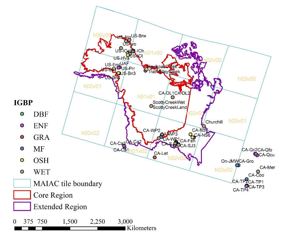
Figure 1. MAIAC tiles, flux sites with their IGBP classes, and ABoVE core and extended domain boundaries. IGBP classes: DBF-deciduous broadleaf forests; ENF-evergreen needleleaf forests; GRA-grasslands; MF-mixed forests; OSH-open shrubland; WET-permanent wetland; OSH-open shrubland; WET-permanent wetland (Yu et al., 2019, in preparation).
Citation
Yu, R., G. Hmimina, K.F. Huemmrich, D.P. Billesbach, A. Lyapustin, Y. Wang, and J.A. Gamon. 2019. ABoVE: Corrected MODIS MAIAC Reflectance at Tower Sites, Alaska and Canada, 2000-2016. ORNL DAAC, Oak Ridge, Tennessee, USA. https://doi.org/10.3334/ORNLDAAC/1700
Table of Contents
- Dataset Overview
- Data Characteristics
- Application and Derivation
- Quality Assessment
- Data Acquisition, Materials, and Methods
- Data Access
- References
Dataset Overview
This data set provides angular corrections of MODIS Multi-Angle Implementation of Atmospheric Correction algorithm (MAIAC) surface reflectances (Lyapustin et al., 2018; product MCD19A1) by two methods at each of 62 flux tower sites (1 km x 1 km area) across the ABoVE domain in Alaska and western Canada from 2000 to 2015/2016. The original MAIAC reflectance data were corrected to consistent view and illumination angles (0 degree view zenith angle and 45 degree of sun zenith angle) using two independent algorithms: the first based on the original BRDF (Bidirectional Reflectance Distribution Function) parameters provided by the MAIAC team, and the second based on a machine learning approach (random forests). The corrected data preserve the original MAIAC data's sub-daily temporal resolution and 1 km spatial resolution with seven land bands (bands 1-7) and five ocean bands (bands 8-12). The resulting tower site sub-daily timeseries of angular corrected surface reflectances are suitable for long-term studies on patterns, processes, and dynamics of surface phenomena since angular effects in bands have been reduced.
The 62 flux tower sites are located across the ABoVE domain (Figure 1) within 10 different Terra and Aqua satellite MODIS MAIAC tiles. The dataset includes the tile ID, latitude and longitude for the center of site located pixel, pixel index in the MAIAC tile for each site, and the distance in kilometers between site location and the pixel center. The dataset also includes the Ross-Thick Li-Sparse (RTLS) volumetric kernel function values (Fv), and geometric-optics kernel function values (Fg) originally provided by MCD19A1. The observation time, sun-view geometry, the cloud and land masks from MCD19A1, and International Geosphere-Biosphere Programme (IGBP) land cover class are also included.
Project: Arctic-Boreal Vulnerability Experiment
The Arctic-Boreal Vulnerability Experiment (ABoVE) is a NASA Terrestrial Ecology Program field campaign based in Alaska and western Canada between 2016 and 2021. Research for ABoVE links field-based, process-level studies with geospatial data products derived from airborne and satellite sensors, providing a foundation for improving the analysis and modeling capabilities needed to understand and predict ecosystem responses and societal implications.
Related Publication:
Yu, R., G. Hmimina, Y. Wang, A. Lyapustin, K.F. Huemmrich, D. Billesbach, Z. Xu, and J. Gamon. 2019. A random forests approach to reduce angular effects in MODIS MAIAC reflectances in high northern latitudes (in prep).
Acknowledgments:
This research "Evaluating growing season length and productivity across the ABoVE Domain using novel satellite indices and a ground sensor network" received funding from the NASA ABoVE Program, grant number NNX15AT78A.
Data Characteristics
Spatial Coverage: Flux tower sites across Alaska and Canada
ABoVE Reference Locations:
Domain: Core and extended ABoVE
State/territory: Alaska and Western Canada
Grid Cells:
Ah1Av0Bh6Bv5Ch36Cv33,Ah1Av0Bh8Bv1Ch50Cv7, Ah1Av0Bh7Bv1Ch46Cv8, Ah1Av0Bh7Bv2Ch42Cv15, Ah1Av0Bh8Bv2Ch53Cv17, Ah1Av0Bh8Bv3Ch53Cv18, Ah1Av0Bh8Bv3Ch48Cv19, Ah1Av0Bh8Bv3Ch50Cv20, Ah1Av0Bh8Bv3Ch48Cv21, Ah1Av0Bh6Bv5Ch40Cv32, Ah1Av0Bh6Bv5Ch41Cv32, Ah1Av0Bh10Bv5Ch65Cv34, Ah1Av0Bh10Bv5Ch64Cv35, Ah1Av1Bh6Bv6Ch40Cv37, Ah1Av1Bh11Bv11Ch69Cv67, Ah1Av2Bh7Bv17Ch45Cv103, Ah1Av2Bh7Bv17Ch45Cv105, Ah2Av1Bh14Bv9Ch89Cv59, Ah2Av2Bh13Bv15Ch79Cv93, Ah2Av2Bh13Bv15Ch78Cv95, Ah2Av2Bh12Bv16Ch76Cv96, Ah2Av2Bh15Bv16Ch92Cv99, Ah2Av2Bh17Bv15Ch105Cv93, Ah2Av2Bh17Bv15Ch107Cv95, Ah2Av2Bh15Bv16Ch92Cv100, Ah2Av2Bh15Bv16Ch91Cv101, Ah2Av2Bh15Bv16Ch93Cv101, Ah2Av2Bh15Bv17Ch91Cv102, Ah2Av2Bh15Bv17Ch94Cv102, Ah2Av3Bh12Bv19Ch73Cv114, Ah3Av2Bh18Bv15Ch108Cv95, Ah3Av2Bh19Bv14Ch117Cv85, Ah3Av2Bh18Bv16Ch108Cv96, Ah4Av3Bh27Bv18Ch163Cv110, Ah4Av3Bh27Bv18Ch164Cv110, Ah4Av3Bh27Bv18Ch165Cv112, Ah4Av3Bh24Bv20Ch147Cv121, Ah4Av3Bh24Bv20Ch148Cv121, Ah4Av3Bh27Bv21Ch166Cv126, Ah4Av3Bh26Bv22Ch156Cv133, Ah4Av3Bh26Bv23Ch156Cv139, Ah4Av3Bh26Bv23Ch156Cv140
Spatial Resolution: Data are provided for 1 km2 pixels at each tower site
Temporal Coverage: 2000-02-24 to 2016-07-31 (Please note: only 12 southern sites have data until 2016-07-31, the rest of sites have data until 2015-04-30)
Temporal Resolution: The number of MAIAC observations within each day varied from 0 to 12, and most sites had one to four observations per day.
Study Areas (All latitude and longitude are given in decimal degrees)
| Site | Westernmost Longitude | Easternmost Longitude | Northernmost Latitude | Southernmost Latitude |
|---|---|---|---|---|
| Alaska and Canada | -157.409 | -74.0365 | 71.3225 | 42.6353 |
Data File Information
This data set includes one data file in .csv format: MAIAC_site_reflectance.csv .
This file provides original MODIS MAIAC bidirectional reflectances, BRDF angular corrected reflectances, and RF angular corrected reflectances plus the site characteristics for 1-km x 1-km pixels located at 62 flux tower sites across Alaska and western Canada.
User Notes:
- Occasionally, BRDF or RF angular corrections give extreme outliers. It is recommended that the interval [0,1] be applied as a filter on corrected reflectances.
- Data are provided from both Terra and Aqua satellites. Variable sat 1 means Terra and 2 means Aqua. Both MODIS “land” bands (1-8) and “ocean” bands (9-12) are included.
- Tower sites US-ICt, US-ICs, and US-ICh are located in the same 1km2 pixel.
- Tower sites CA-NS1 and CA-Man are located in the same pixel.
- Tower sites CA-NS3 and CA-NS4 are located in the same pixel.
Table 1. Variables in the data file
Decimal Degrees
| Column # | Variable | Units | Description |
|---|---|---|---|
| 1 | year | YYYY | Year (MODIS) |
| 2 | j_date | DD | DOY (MODIS) |
| 3 | hour | hh | Hour (MODIS) |
| 4 | minute | mm | Minute (MODIS) |
| 5 | site_id | Flux site name (AmeriFlux, https://ameriflux.lbl.gov) | |
| 6 | canada_id | Canada flux site name (if there is one, AmeriFlux, https://ameriflux.lbl.gov) | |
| 7 | igbp | International Geosphere-Biosphere Programme land cover classes: DBF-deciduous broadleaf forests, ENF-evergreen needleleaf forests, GRA- grasslands, MF-mixed forests, OSH-open shrubland, and WET-permanent wetland | |
| 8 | latitude | Decimal Degrees | Tower site latitude |
| 9 | longitude | Decimal Degrees | Tower site longitude |
| 10 | tile_id | The corresponding MODIS MAIAC tile ID for each flux site | |
| 11 | pixel_latitude | Decimal Degrees | Latitude for the center of site located pixel |
| 12 | pixel_longitude | Decimal Degrees | Longitude for the center of site located pixel |
| 13 | pixel_index | Pixel index in the MAIAC tile for each site | |
| 14 | min_dist_square | km | Minimal distance in kilometer between site location and the pixel center |
| 15 | pixel_row | Pixel row index in the MAIAC tile for each site | |
| 16 | pixel_col | Pixel column index in the MAIAC tile for each site | |
| 17 | relative_az | Degrees | Relative azimuth |
| 18 | scattering_angle | Degrees | Scattering angle |
| 19 | cos_sza | Cosine of Solar Zenith Angle | |
| 20 | cos_vza | Cosine of View Zenith Angle | |
| 21 | fv | Volumetric kernel | |
| 22 | fg | Geometric kernel | |
| 23-34 | brf_b1 to brf_b12 | Original MODIS MAIAC surface bidirectional reflectance for bands 1 to 12: band 1 data is column 23; band 12 is column 34 | |
| 35 | cloud_mask |
Cloud mask values inherited from the original MCD19A1 data file: 0 --- Undefined 1--- Clear 2 --- Possibly Cloudy (detected by AOT filter) 3 --- Cloudy (detected by cloud mask algorithm) 5 -- - Cloud Shadow 6 --- hot spot of fire 7 --- Water Sediments |
|
| 36 | land_water_snow_ice_mask |
Land water snow/ice mask values inherited from the original MCD19A1 data file: 0 --- Land 1 --- Water 2--- Snow 3 --- Ice |
|
| 37 | saz | Degree | Solar Azimuth Angle |
| 38 | vaz | Degree | View Azimuth Angle |
| 39 | satellite | Satellite: Terra or Aqua | |
| 40-51 | brdf_ref1 to brdf_ref12 | BRDF corrected surface bidirectional reflectance for bands 1 to 12: band 1 data is column 40; band 12 is column 51 | |
| 52-63 | rf_ref1 to rf_ref12 | Random forest corrected surface bidirectional reflectance for bands 1 to 12: band 1 data is column 52; band 12 is column 63 |
Application and Derivation
This dataset provides angular corrected sub-daily surface land and ocean band reflectances at flux tower sites in boreal and Arctic regions over the ABoVE domain. These data can help interpret ground observations, can provide a better understanding long-term processes and dynamics of surface phenomena at these flux towers locations in high latitudes, and can be used for developing upscaling approaches from flux tower sites using MODIS data (Yu et al., 2019, in preparation.).
Quality Assessment
Two quality assessment variables (cloud mask and land mask) are provided, which are inherited from the original MAIAC dataset.
User note: Occasionally, BRDF or RF angular corrections give extreme outliers. It is recommended that the interval [0,1] be applied as a filter on corrected reflectances.
Data Acquisition, Materials, and Methods
Input MODIS MAIAC Data
This angular correction dataset was based on the MODIS MAIAC BRF product. The pre-Collection 6 data were obtained directly from the MAIAC team and were slightly different from the currently-available MCD19a1v006 product from Lyapustin and Wang (2018).
All original MAIAC reflectances were extracted from 1-km x 1-km pixels centered at each flux tower in 10 MODIS tiles. Please note flux tower sites (US-ICt, US-ICs, and US-ICh), (CA-NS1 and CA-Man), and (CA-NS3 and CA-NS4) are located in the same pixels, respectively.
The MODIS MAIAC BRF product improves accuracy of cloud detection, aerosol retrievals and atmosphere correction by integrating space and time in the image process and provides additional MODIS ocean bands (8-12). The BRDF parameters in original MAIAC data sometimes are missing or have a low quality during winter and seasonal transitions at high latitudes. Our new angular correction dataset used a random forests (RF) approach to reduce solar-view geometry effects on satellite measurements and provided a new kind of angular corrected reflectance product (Yu et al., 2019, in preparation).
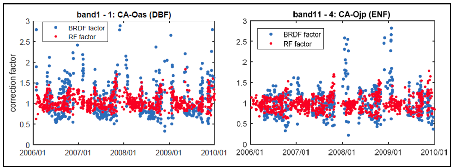
Figure 2. Examples of angular correction factors (BRDF and RF-derived) calculated for MAIAC MODIS band 1 for a deciduous broadleaf forest flux tower site (1 x 1 km2 pixel), and band 11 for an evergreen needleleaf forest flux tower site (1 x 1 km2 pixel). These examples illustrate that the RF approach resulted in fewer missing values and outliers (>=2) across bands and ecosystems relative to BRDF (Yu et al., 2019, in preparation).
BRDF based angular correction
Angular correction factor was defined as a ratio of reflectances for a fixed viewing geometry to that for measured viewing geometry. In this dataset, normalized geometry represents nadir view (0°) and 45° degree sun zenith angle (SZA). For BRDF based angular correction, only original MAIAC BRDF model parameters were used to ensure the correction quality. The BRDF based angular correction factors were calculated as equation (1) (e.g., see Lyapustin et al., 2018), and BRDF corrected reflectances were calculated as equation (2). When the BRDF based angular correction factors were out of range [0 2], they were removed as outliers.
Fn = (kL - 0.0458621*kV - 1.1068192*kG)/( kL + Fv*kV + Fg*kG) (1)
BRFn = FBRDF * BRF (2)
Where:
Fn is BRDF based angular correction factor
Fv and Fg are Ross Thick Lee Sparse (RTLS) volumetric and geometric-optics kernel function values, respectively
kL, kV, kG are RTLS isotropic, volumetric, and geometric kernel parameters, respectively
BRFn is BRDF based angular corrected reflectance
BRF is original bidirectional reflectance
The MODIS MAIAC provided BRDF model parameters for bands 1-8, thus, for ocean bands 9-12, the parameters from the nearest land bands were used, which were bands 3, 3, 4, and 4, respectively.
RF based angular correction
Across the MODIS tiles, 2,683 randomly sampled pixels among a total of 9,601,890 vegetated pixels were used in a “local” random forest model (LRF) for building a “global” random forest model (GRF), which was then applied across the entire study region. LRF derived correction factors were compared to BRDF correction factors. There were good agreements between the two during summer and LRF derived correction factors performed better during seasonal transitions and winter.
For the LRF, all MODIS bands were used as prediction (dependent) variables. The input (independent) variables include time variables, which are year and day of year; the spectrum variable, which is band wavelength; the viewing geometry variables including solar zenith angle (SZA), view zenith angle (VZA), solar azimuth angle (SAZ), view azimuth angle (VAZ), scattering angle, as well as the earth surface condition and vegetation structure and greenness indices NDVI (normalized difference vegetation index), NDSI (normalized difference snow index), NDWI (normalized difference water index for plant canopy water content), and NDWI_2 (normalized difference water index for surface water). The LRF was applied to each individual sampled pixel.
The GRF was created based on angular correction factors of all sampled pixels. Here, the dependent variable was FRF and the independent variables were reflectances (bands 1-12), the viewing geometry variables, and two RTLS parameters, Fv and Fg. Angular correction factors were extrapolated for 62 flux tower sites located in 57 pixels (towers were in 10 of the tiles) with known IGBP vegetation types (Figure 2). Angular corrected reflectances (BRFRF) were calculated by multiplying BRF and FRF and then used for tile level reflectance correction. The general workflow is provided in Figure 3 (Yu et al., 1019, in preparation).
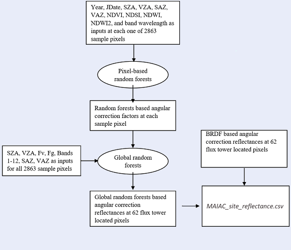
Figure 3. A general workflow chart on achieving angular corrected reflectances with BRDF and RF approaches at 1-km resolution for 62 flux tower sites. Year: observation year; JDate: observation day of year; SZA: solar zenith angle; VZA: view zenith angle; NDVI: normalized difference vegetation index, (band2 – band1)/ (band2 + band1); NDSI: normalized difference snow index, (band4 – band6)/ (band4 + band6); NDWI: normalized difference water index (vegetation water), (band2 – band5)/ (band2 + band5); NDWI2: normalized difference water index (surface water), (band4 – band2)/ (band4 + band2); Fv: RTLS volumetric kernel; Fg: RTLS geometric kernel; SAZ: solar azimuth angle; VAZ: view azimuth angle (Yu et al., 2019, in preparation).
Data Access
These data are available through the Oak Ridge National Laboratory (ORNL) Distributed Active Archive Center (DAAC).
ABoVE: Corrected MODIS MAIAC Reflectance at Tower Sites, Alaska and Canada, 2000-2016
Contact for Data Center Access Information:
- E-mail: uso@daac.ornl.gov
- Telephone: +1 (865) 241-3952
References
A. Lyapustin, Y. Wang (2018). MCD19A1 MODIS/Terra+Aqua Land Surface BRF Daily L2G Global 500m and 1km SIN Grid V006. NASA EOSDIS Land Processes DAAC. https://doi.org/10.5067/MODIS/MCD19A1.006.
A. Lyapustin, Y. Wang, S. Korkin, D. Huang (2018). MODIS Collection 6 MAIAC Algorithm. Atmos. Meas. Tech., 11, 5741-5765, https://doi.org/10.5194/amt-11-5741-2018.
Yu, R., G. Hmimina, Y. Wang, A. Lyapustin, K.F. Huemmrich, D. Billesbach, J. Zhang, Holland Computing Center, Z. Xu, and J. Gamon. 2019. A random forests approach to reduce angular effects in MODIS MAIAC reflectances in high northern latitudes (in preparation).