Documentation Revision Date: 2025-07-28
Dataset Version: 1
Summary
This dataset holds 599 files in netCDF format and two Jupyter notebooks.
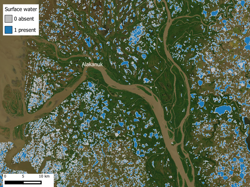
Figure 1. Occurrence of surface water in Yukon-Kuskokwim Delta near Alakanuk, Alaska, during week 35 of 2017 (2017-09-03 to 2017-09-09). Surface water presence-absence was estimated from Sentinel-2 imagery for pixels with a lake-and-pond analysis mask. Map center at approximately 62.760 latitude, -164.489 longitude. Source: surface_water_YKD_wk35.nc
Citation
Webb, E.E., E. Levenson, S.W. Cooley, and J. Maze. 2025. ABoVE: Lakes and Ponds Weekly Occurrence, 2016 - 2023. ORNL DAAC, Oak Ridge, Tennessee, USA. https://doi.org/10.3334/ORNLDAAC/2430
Table of Contents
- Dataset Overview
- Data Characteristics
- Application and Derivation
- Quality Assessment
- Data Acquisition, Materials, and Methods
- Data Access
- References
Dataset Overview
This dataset provides weekly surface water occurrence across lakes and ponds in six study regions: the Alaskan Coastal Plain, Yukon Flats, Yukon Kuskokwim Delta, Mackenzie River Delta, Tuktoyaktuk Peninsula, and Anderson Plain. The study regions are in Alaska, US, and Yukon and Northwest Territories, Canada. This binary (water or not water) raster product is built from Sentinel-2 imagery and a maximum lake extent vector product also produced from Sentinel-2 imagery. When cloud-free imagery was available, raster files were produced at 10 m spatial resolution and weekly temporal resolution during the ice-free season (May-September) for the period 2016-2023. Open water was differentiated from land using an adaptive NDWI threshold water classification algorithm and then clipped to the lake and ponds vector product so that only lake and pond water is reported.
Project: Arctic-Boreal Vulnerability Experiment
The Arctic-Boreal Vulnerability Experiment (ABoVE) is a NASA Terrestrial Ecology Program field campaign being conducted in Alaska and western Canada, for 8 to 10 years, starting in 2015. Research for ABoVE links field-based, process-level studies with geospatial data products derived from airborne and satellite sensors, providing a foundation for improving the analysis, and modeling capabilities needed to understand and predict ecosystem responses to, and societal implications of, climate change in the Arctic and Boreal regions.
Related Dataset
Levenson, E., S.W. Cooley, and A. Mullen. 2025. ABoVE: Alaska Lake and Pond Occurrence. ORNL DAAC, Oak Ridge, Tennessee, USA. https://doi.org/10.3334/ORNLDAAC/2399
Acknowledgments
This research was supported by NASA's Future Investigators in Earth and Space Sciences and Technology (grant 80NSSC23K1556) and the National Science Foundation Office of Polar Programs (grant 2317873).
Data Characteristics
Spatial Coverage: Alaska, USA; Yukon and Northwest Territories, Canada
Spatial Resolution: 10 m
Temporal Coverage: 2016-05-06 to 2023-10-14
Temporal Resolution: one-time estimate
Study Area: Latitude and longitude are given in decimal degrees.
| Study Regions | Westernmost Longitude | Easternmost Longitude | Northernmost Latitude | Southernmost Latitude |
|---|---|---|---|---|
| Alaska Coastal Plain | -163.1576 | -135.7107 | 71.3908 | 68.3987 |
| Tuktoyaktuk Peninsula - Mackenzie River Delta |
-137.2072 | -128.7254 | 70.2538 | 67.4968 |
| Yukon-Kuskokwim Delta | -166.1939 | -158.6242 | 63.4415 | 59.4373 |
| Yukon Flats | -150.0419 | -141.9816 | 67.4615 | 65.7150 |
Data File Information
This dataset holds 599 files in netCDF format (.nc) and two Jupyter notebooks (.ipynb). The netCDFs hold spatial data on the presence and absence of surface water within a lake/pond mask during the summer months. There is one netCDF for each weekly estimate. Files for weeks lacking useful Sentinel-2 images are not included (see Section 4).
The netCDF file naming convention is surface_water_<area>_<year>_wk<week>.nc, where
- <area> indicates the study region: "AKCP" = Alaskan Coastal Plain, "YKF"= Yukon Flats, "YKD" = Yukon-Kuskokwim Delta,
"TUK_MRD" = Tuktoyaktuk Peninsula and Mackenzie River Delta - <year> is the year between 2016 to 2023
- <week> is the week of the given year
Example file names :surface_water_AKCP_2016_wk19.nc , surface_water_TUK_MRD_2022_wk26.nc, surface_water_YKF_2017_wk23.nc
Geospatial characteristics of the netCDFs
- Coordinate system: geographic coordiates in WGS 84 datum (EPSG 4326)
- Spatial resolution: 0.00009 degree, or ~10 m
- Nodata value for occurrence variable: 2
- Data type = unsigned byte (ubyte)
The two Jupyter notebooks hold code for processing the Sentinel-2 images and generating the surface water occurrence classification. The notebooks utilize Google Earth Engine.
- Batch_LakeOccurrence.ipynb - Script used to derive weekly surface water occurrence from Sentinel-2 top-of-atmosphere reflectance. For each Sentinel-2 tile in each year, the code generates a daily cloud-masked Sentinel-2 mosaic, filters to remove images below the defined ice and cloud threshold, classifies water in each image using an adaptive NDWI thresholding algorithm, determines the maximum water occurrence for each pixel (i.e., water or not water), clips to the maximum lake extent mask, and exports a weekly surface water occurrence raster .
- WeeklyMosaic.ipynb - Script used to remove erroneous tiles and mosaic regional classified surface water occurrence tiles to produce a composite weekly regional lake and pond surface water occurrence raster. For each week of year in each region, the code generates the list of rasters (i.e., classified tiles) produced from Batch_LakeOccurence.ipynb, filters out tiles where surface water occurrence was less than 50% of the expected lake area and the number of individual lakes was less than 30% of the expected number, and generates one maximum weekly surface water extent raster for the whole region.
Table 1. Variables in the netCDFs.
| Variable | Units | Description |
|---|---|---|
| occurrence | 1 | Binary classification of presence (1) or absence (0) of surface water |
| time | d | Middle day of each weekly time step in days since 2016-01-01 |
| time_bnds | d | Beginning day and ending day of each weekly time step in days since 2016-01-01 |
| week | 1 | Week of the given year |
| year | YYYY | Year |
| lat | degrees north | Latitude of pixel in decimal degrees |
| lon | degrees east | Longitude of pixel in decimal degrees |
Application and Derivation
This dataset is suitable for investigations of individual water bodies as well as lake and pond seasonal and interannual areal patterns across the study regions.
Quality Assessment
Each study region was split and processed according to the Sentinel-2 tiling grid (110 km x 110 km pre-defined granules covering the earth). Some of these tiles produced erroneously low surface water occurrence due to haze or small differences in surface reflectance values between water and land. To address this issue, tiles were removed where surface water occurrence was less than 50% of the expected lake area and the number of individual lakes was less than 30% of the expected number. The lake area and number were determined from the metadata of the lake polygon database (Levenson et al., (2025).
Data Acquisition, Materials, and Methods
Each study region (Figure 2) was split and processed according to the Sentinel-2 tiling grid (110 km x 110 km pre-defined granules covering the earth). Within each tile, a median composite of cloud-free Sentinel-2 top of atmosphere (TOA) images was constructed for every week between May and September 2016-2023. Cloud presence was identified using a 50% cloud probability threshold from the Sentinel-2 cloud probability product and ice-covered pixels were flagged based on high reflectance in the red band (values ≥ 1050). Tiles were excluded if more than 30% of the tile was cloud-covered or if more than 10% of the tile was ice-covered. Open land was differentiated from water using an adaptive Normalized Difference Water Index (NDWI) thresholding algorithm (Cooley et al., 2017; Cooley et al., 2019) applied to each of the weekly cloud-masked mosaics (see Levenson et al., (2025) for more details). All tiles within a region were composited to create a weekly open water raster product and clipped to the lake-and-ponds vector product so that only lake and pond water within the polygons is reported.
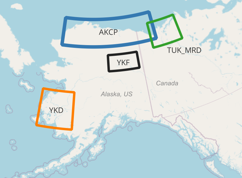
Figure 2. Study regions for weekly surface water occurrence. "AKCP" = Alaskan Coastal Plain, "YKF"= Yukon Flats, "YKD" = Yukon-Kuskokwim Delta, "TUK_MRD" = Tuktoyaktuk Peninsula and Mackenzie River Delta.
Data Access
These data are available through the Oak Ridge National Laboratory (ORNL) Distributed Active Archive Center (DAAC).
ABoVE: Lakes and Ponds Weekly Occurrence, 2016 - 2023
Contact for Data Center Access Information:
- E-mail: uso@daac.ornl.gov
- Telephone: +1 (865) 241-3952
References
Cooley, S., L. Smith, L. Stepan, and J. Mascaro. 2017. Tracking dynamic northern surface water changes with high-frequency Planet CubeSat imagery. Remote Sensing 9:1306. https://doi.org/10.3390/rs9121306
Cooley, S.W., L.C. Smith, J.C. Ryan, L.H. Pitcher, and T.M. Pavelsky. 2019. Arctic-Boreal lake dynamics revealed using CubeSat imagery. Geophysical Research Letters 46:2111–2120. https://doi.org/10.1029/2018GL081584
Levenson, E., S.W. Cooley, and A. Mullen. 2025. ABoVE: Alaska Lake and Pond Occurrence. ORNL DAAC, Oak Ridge, Tennessee, USA. https://doi.org/10.3334/ORNLDAAC/2399