Documentation Revision Date: 2022-02-06
Dataset Version: 1
Summary
All data were collected under the principles of informed consent and in accordance with the State of Alaska confidentiality statute (AS 16.05.815) and have been reviewed by their respective communities. All data are confidential at the household level and only reported at the community level in the provided maps.
There are three shapefiles provided with this dataset showing community use areas: (1) points marking localized search and harvest areas, (2) polygons indicating larger search and harvest effort areas, and (3) lines indicating linear search and harvesting activity. The data in the shapefiles are provided as companion files in .kmz format for viewing in Google Earth.
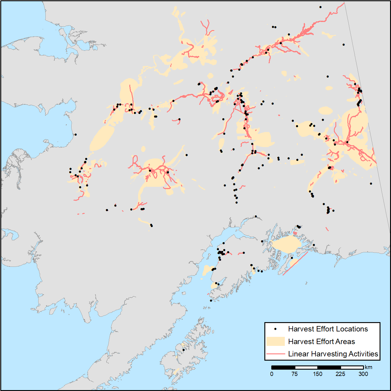
Figure 1. Combined map of subsistence resource use areas of Interior Alaskan communities (1) points marking harvest effort locations, (2) polygons indicating harvest effort areas, and (3) lines indicating linear harvesting activity.
Citation
Neufeld, G., L. Naaktgeboren, D. Gonzalez, and C. Brown. 2019. ABoVE: Subsistence Resource Use Areas of Interior Alaskan Communities, 2011-2017. ORNL DAAC, Oak Ridge, Tennessee, USA. https://doi.org/10.3334/ORNLDAAC/1725
Table of Contents
- Dataset Overview
- Data Characteristics
- Application and Derivation
- Quality Assessment
- Data Acquisition, Materials, and Methods
- Data Access
- References
Dataset Overview
This dataset provide maps to show the search and harvest areas used by community residents for all subsistence resources combined across Interior Alaska for the years 2011 through 2017. The maps show the extent of areas used by residents for those communities where data collection and research has occurred; it is not a comprehensive use map for the entire area. The maps are a composite of data collected by the Division of Subsistence, Alaska Department of Fish and Game using standardized methods where respondents indicated the search areas for species harvested, the amounts harvested, and the location and months of harvest. These data are important for research, analysis and regulatory assessment.
All data were collected under the principles of informed consent and in accordance with the State of Alaska confidentiality statute (AS 16.05.815) and have been reviewed by their respective communities. All data are confidential at the household level and only reported at the community level in the provided maps.
Related Dataset:
H.S. Cold, T.J. Brinkman, C. Adams, A. Demientieff, I. Demientieff, R. Demientieff, E. Frank, G. Frank, D. Painter, J. Roberts, M. Snyder, C. Taylor, J. Turner, C. Wallace, and M. Walsh. 2019. ABoVE: Environmental Conditions and Subsistence Resource Access, Alaska, 2016-2017. ORNL DAAC, Oak Ridge, Tennessee, USA. https://doi.org/10.3334/ORNLDAAC/1705
Acknowledgements:
The production of this map was supported by funding from NASA ABoVE as part of a larger project entitled, Biophysical Characteristics and Mechanisms of Environmental Disturbances Influencing Human Access to Ecosystem Services in Boreal Alaska (NNX15AT72A).
Data Characteristics
Spatial Coverage: Interior Alaska, USA
Spatial Resolution: multiple points
Temporal Coverage: 2011-01-01 to 2017-12-31
Temporal Resolution: weekly, monthly, or seasonally
Study Area: (all latitudes and longitudes given in decimal degrees)
|
Site |
Westernmost |
Easternmost |
Northernmost |
Southernmost |
|---|---|---|---|---|
|
Alaska, USA |
-176.646194 |
-131.525255 |
70.147682 |
51.713349 |
Data File Information
There are three compressed (*.zip) shapefiles provided with this dataset showing community use areas: (1) points marking harvest effort locations, (2) polygons indicating harvest effort areas, and (3) lines indicating linear harvesting activity. The data in the shapefiles are provided as companion files in .kmz format for viewing in Google Earth.
There is only a single attribute for each of the maps – indicating the name of the community using the area.
Data Files:
| File Name | Description |
|---|---|
| Interior_Alaska_Subsistence_Use_Areas_Points.zip | Compressed shapefile with points marking harvest effort locations |
| Interior_Alaska_Subsistence_Use_Areas_Polygons.zip | Compressed shapefile with polygons indicating harvest effort areas |
| Interior_Alaska_Subsistence_Use_Areas_Lines.zip | Compressed shapefile with lines indicating linear harvesting activity such as trapping and trolling |
Spatial Reference Properties:
EPSG: 3338
Detail:
NAD_1983_Alaska_Albers
Projection: Albers
False_Easting: 0.0
False_Northing: 0.0
Central_Meridian: -154.0
Standard_Parallel_1: 55.0
Standard_Parallel_2: 65.0
Latitude_Of_Origin: 50.0
Linear Unit: Meter (1.0)
Geographic Coordinate System: GCS_North_American_1983
Angular Unit: Degree (0.0174532925199433)
Prime Meridian: Greenwich (0.0)
Datum: D_North_American_1983
Spheroid: GRS_1980
Semimajor Axis: 6378137.0
Semiminor Axis: 6356752.314140356
Inverse Flattening: 298.257222101
Shapefile Attribute:
The attribute name for the all three shapefiles is “commName” and includes records such as those listed below from the '*_ Points.shp' file.
| FID | Community Name |
|---|---|
| 0 | Anderson |
| 1 | Anvik |
| 2 | Dot Lake |
| 3 | Fort Yukon |
| 4 | Galena |
| 5 | Grayling |
| 6 | Healy |
| 7 | Healy Lake |
| 8 | Manley |
| 9 | McKinley |
| 10 | Minto |
| 11 | Nenana |
| 12 | Nikolai |
| 13 | Northway |
| 14 | Nulato |
| 15 | Rampart |
| 16 | Ruby |
| 17 | Shageluk |
| 18 | Stevens Village |
| 19 | Tanana |
| 20 | Tok |
| 21 | McGrath |
| 22 | Eagle |
| 23 | Eagle Village |
Application and Derivation
These data are important for research, analysis and regulatory assessment. Alaska Statute 16.05.094 requires the Division of Subsistence, ADF&G, to conduct studies and compile existing data on all aspects of the role of subsistence hunting and fishing in the lives of state residents. The Division must also make this information available to the public, appropriate agencies, and other bodies. Copies of this map are available for viewing on the Division’s website (https://www.adfg.alaska.gov/) and copies may be made available upon request through the ADF&G office in Fairbanks.
Quality Assessment
Data were collected using a standardized method where respondents indicate the search areas for species harvested, the amounts harvested, and the location and months of harvest. Data collection maps were usually produced for individual projects using ArcGIS software. Survey maps were typically produced at various scales and extents to accommodate both local and distant searches and harvests.
Data Acquisition, Materials, and Methods
The provided maps are a composite of subsistence search areas for Interior Alaska collected by the Division of Subsistence, Alaska Department of Fish and Game (ADF&G) for 2011 to 2017. These data are important for research, analysis and regulatory assessment.
Alaska Statute 16.05.094 requires the Division of Subsistence, ADF&G, to conduct studies and compile existing data on all aspects of the role of subsistence hunting and fishing in the lives of state residents. The Division must also make this information available to the public, appropriate agencies, and other bodies.
The map is a composite of previously collected spatial data depicting the search and harvest areas used by community residents for all subsistence resources combined in specific years. It shows the extent of area in Interior Alaska used by residents for subsistence uses for communities where research has occurred; it is not a comprehensive use map for the area.
Data were collected using a standardized method where respondents indicate the search areas for species harvested, the amounts harvested, and the location and months of harvest.
- Points were used to mark localized search and harvest areas.
- Polygons (shaped areas) were used to indicate harvest effort areas, such as areas searched while hunting moose.
- Lines were also drawn when the harvesting activity did not occur at a specific point, such as trapping and trolling.
Data collection maps were usually produced for individual projects using ArcGIS software. Survey maps were typically produced at various scales and extents to accommodate both local and distant searches and harvests.
All data were collected under the principles of informed consent and in accordance with the State of Alaska confidentiality statute (AS 16.05.815) and have been reviewed by their respective communities. All data are confidential at the household level and only reported on the community level. Copies of this map are available for viewing on the Division’s website (https://www.adfg.alaska.gov/) and copies may be made available upon request through the ADF&G office in Fairbanks.
Data Access
These data are available through the Oak Ridge National Laboratory (ORNL) Distributed Active Archive Center (DAAC).
ABoVE: Subsistence Resource Use Areas of Interior Alaskan Communities, 2011-2017
Contact for Data Center Access Information:
- E-mail: uso@daac.ornl.gov
- Telephone: +1 (865) 241-3952
References
H.S. Cold, T.J. Brinkman, C. Adams, A. Demientieff, I. Demientieff, R. Demientieff, E. Frank, G. Frank, D. Painter, J. Roberts, M. Snyder, C. Taylor, J. Turner, C. Wallace, and M. Walsh. 2019. ABoVE: Environmental Conditions and Subsistence Resource Access, Alaska, 2016-2017. ORNL DAAC, Oak Ridge, Tennessee, USA. https://doi.org/10.3334/ORNLDAAC/1705