Documentation Revision Date: 2023-10-18
Dataset Version: 1
Summary
This dataset includes three files in comma-separated values (CSV) format.
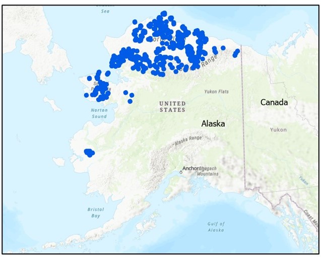
Figure 1. Locations (blue dots) of field sites in the Alaskan tundra that contributed data to this synthesis database.
Citation
Chen, D., X. Zhu, M. Kogure, E.E. Hoy, X. Xu, N.H.F. French, L.T. Berner, A.L. Breen, S. Bret-Harte, S.J. Davidson, J.J. Ebersole, G.V. Frost, S.J. Goetz, R.E. Hewitt, J.K.Y. Hung, C.M. Iversen, G. Iwahana, R. Jandt, L.K. Jenkins, A.N. Kade, I. Klupar, T.V. Loboda, S. Ludwig, M.J. Macander, M.C. Mack, C.R. Meyers, R.J. Michaelides, E.A. Miller, S. Natali, T.W. Nawrocki, P.R. Nelson, A.D. Parsekian, E. Rastetter, M.K. Raynolds, A.V. Rocha, K. Schaefer, U. Schickhoff, E.A.G. Schuur, S. Tsuyuzaki, C.E. Tweedie, S.V. Zesati, D.A. Walker, P.J. Webber, M. Williams, and D. Zona. 2023. Field Data on Soils, Vegetation, and Fire History for Alaska Tundra Sites, 1972-2020. ORNL DAAC, Oak Ridge, Tennessee, USA. https://doi.org/10.3334/ORNLDAAC/2177
Table of Contents
- Dataset Overview
- Data Characteristics
- Application and Derivation
- Quality Assessment
- Data Acquisition, Materials, and Methods
- Data Access
- References
Dataset Overview
This dataset, titled the Synthesized Alaskan Tundra Field Database (SATFiD), provides a comprehensive collection of in-situ field data compiled from 37 existing datasets resulting from field surveys conducted at Alaska tundra sites between 1972 to 2020. The data were harmonized prior to being included in this dataset. The variables include active layer thickness, vegetation cover (by plant functional types), soil moisture and temperatures, as well as the wildfire history. SATFiD provides a unique lens into various long-term ecological processes within the tundra (such as the fire-permafrost-vegetation interactions) under a rapidly changing climate.
Project: Arctic-Boreal Vulnerability Experiment
The Arctic-Boreal Vulnerability Experiment (ABoVE) is a NASA Terrestrial Ecology Program field campaign being conducted in Alaska and western Canada, for 8 to 10 years, starting in 2015. Research for ABoVE links field-based, process-level studies with geospatial data products derived from airborne and satellite sensors, providing a foundation for improving the analysis, and modeling capabilities needed to understand and predict ecosystem responses to, and societal implications of, climate change in the Arctic and Boreal regions.
Related Datasets
Related datasets are listed in Table 2 below.
Acknowledgement
The development of this database and some related field projects were supported by NASA's Terrestrial Ecology Program (grant 80NSSC19M0106).
Data Characteristics
Spatial Coverage: Tundra ecosystems in Alaska
ABoVE Reference Locations
Domain: Core and extended
State/Territory: Alaska
Grid cells: Ah000v000, Ah001v000, Bh002v003, Bh003v001, Bh004v001, Bh004v002, Bh004v003, Bh005v001, Bh005v002, Bh006v001, Bh006v002, Bh006v003, Bh007v000, Bh007v001, Bh007v002, Bh007v003, Bh008v001, Bh008v002, Bh008v003, Bh009v002, Bh009v003, Bh009v004, Ch013v021, Ch013v022, Ch014v021, Ch014v022, Ch022v010, Ch023v011, Ch024v011, Ch024v013, Ch025v008, Ch025v011, Ch025v013, Ch025v014, Ch026v011, Ch026v012, Ch026v013, Ch027v009, Ch027v010, Ch027v011, Ch027v012, Ch027v013, Ch028v008, Ch028v011, Ch029v010, Ch029v018, Ch030v009, Ch030v016, Ch030v017, Ch031v009, Ch032v008, Ch032v009, Ch033v007, Ch033v008, Ch033v009, Ch033v010, Ch034v008, Ch034v009, Ch034v010, Ch035v008, Ch035v009, Ch035v012, Ch036v007, Ch036v008, Ch036v009, Ch036v010, Ch036v011, Ch036v012, Ch036v013, Ch036v015, Ch037v008, Ch037v009, Ch037v010, Ch037v011, Ch037v012, Ch037v013, Ch037v014, Ch038v009, Ch038v011, Ch038v012, Ch038v016, Ch038v017, Ch039v010, Ch039v012, Ch039v013, Ch039v014, Ch039v015, Ch039v017, Ch039v018, Ch040v007, Ch040v008, Ch040v015, Ch040v016, Ch040v018, Ch041v006, Ch041v008, Ch041v014, Ch041v015, Ch041v016, Ch041v017, Ch042v006, Ch042v008, Ch042v013, Ch042v014, Ch042v015, Ch042v016, Ch042v019, Ch043v004, Ch043v006, Ch043v007, Ch043v008, Ch043v009, Ch043v010, Ch043v013, Ch043v015, Ch043v016, Ch043v018, Ch043v019, Ch043v020, Ch044v010, Ch044v014, Ch044v016, Ch044v017, Ch044v020, Ch045v007, Ch045v008, Ch045v009, Ch045v010, Ch045v012, Ch045v013, Ch045v014, Ch045v018, Ch045v019, Ch045v020, Ch045v021, Ch046v007, Ch046v008, Ch046v009, Ch046v010, Ch046v011, Ch046v012, Ch046v014, Ch046v015, Ch046v022, Ch047v007, Ch047v008, Ch047v009, Ch047v010, Ch047v011, Ch047v012, Ch047v013, Ch047v014, Ch047v015, Ch047v016, Ch047v020, Ch047v021, Ch047v022, Ch048v007, Ch048v008, Ch048v009, Ch048v010, Ch048v011, Ch048v012, Ch048v014, Ch048v015, Ch048v016, Ch048v017, Ch048v018, Ch048v019, Ch048v020, Ch048v021, Ch049v007, Ch049v009, Ch049v013, Ch049v014, Ch049v015, Ch049v017, Ch049v018, Ch049v019, Ch049v020, Ch049v021, Ch050v007, Ch050v009, Ch050v010, Ch050v011, Ch050v014, Ch050v015, Ch050v019, Ch050v020, Ch050v022, Ch051v012, Ch051v013, Ch051v014, Ch051v015, Ch051v018, Ch051v019, Ch051v020, Ch051v021, Ch052v016, Ch052v018, Ch053v015, Ch053v016, Ch053v017, Ch053v018, Ch053v019, Ch053v022, Ch053v023, Ch054v017, Ch055v023, Ch056v026, Ch057v026
Spatial Resolution: Field plots and transects at point locations
Temporal Coverage: 1972-08-01 to 2020-08-15
Temporal Resolution: Seasonal
Study Area: (All latitudes and longitudes given in decimal degrees)
| Study Area | Westernmost Longitude | Easternmost Longitude | Northernmost Latitude | Southernmost Latitude |
| Alaska | -166.4104 | -141.6834 | 71.3340 | 61.1397 |
Data File Information
There are three files in this dataset in comma-separated values (CSV) format:
- Tundra_field_database.csv provides field data compiled from 37 sources.
- Dataset_List.csv lists the data sources with citation information. The "dataset_id" field links data sources to records in Tundra_field_database.csv.
- Method_Differences.csv provides notes on the measurement methods employed for selected variables (Table 1) by data source. The "dataset_id" field links data sources to records in Tundra_field_database.csv.
The nodata values are -999 for numeric fields and NA for character fields.
Table 1. Variables in Tundra_field_database.csv .
| Variable | Units | Description |
|---|---|---|
| plot_id | - | A unique ID for every plot included |
| dataset_id | - | Dataset ID number |
| dataset_name | - | Name of dataset |
| latitude | degree north | Latitude of plot |
| longitude | degree east | Longitude of plot |
| date | YYYYMMDD | Date of data collection. Note: if a data point's collection month and/or day are unrecorded, their values are set to 0. |
| plot_original_id | - | Plot ID as defined in original dataset |
| soil_temp_10cm | degree C | Surface temperature at 10-cm depth (degrees Celsius) |
| pH | 1 | Soil pH |
| water_table | cm | Water table (cm) |
| soil_moist | 1 | Volumetric water content in percent |
| ALT_mean | cm | Active layer thickness (cm) |
| org_soil_depth | cm | Organic soil depth (cm) |
| LAI_mean | 1 | Leaf area index |
| shrub_height | cm | Shrub height (cm) |
| stem_count | 1 | Stem count |
| moss_cover | 1 | Moss cover in percent |
| lichen_cover | 1 | Lichen cover in percent |
| graminoid_cover | 1 | Graminoid cover in percent |
| forb_cover | 1 | Forb cover in percent |
| shrub_cover | 1 | Shrub cover in percent |
| bare_cover | 1 | Bare soil cover in percent |
| litter_cover | 1 | Litter cover in percent |
| harv_bio | g m-2 | Harvested biomass (g per m2) |
| yr_data | YYYY | Year of data collection (YYYY) |
| burned_status | - | Whether plot was burned in the past at the time of data collection ("Burned" or "Unburned") |
| freq_pre | 1 | Number of times wildfires occurred prior to data collection |
| yr_lfire | YYYY | Year of last known wildfire before data collection |
| n_yr_lfire | y | Number of years between last known wildfire before data collection and data collection |
| dnbr | 1 | Difference Normalized Burn Ratio (dNBR) of the last known wildfire before data collection based on Landsat-derived Burn Scar dNBR dataset |
| all_fire_yrs | YYYY | Years of all known wildfires occurred at this point (comma-separated list) |
| yr_nfire | YYYY | Year of next known wildfire after data collection |
| yrs_nfire | y | Number of years between data collection and next known wildfire after data collection |
| freq_total | 1 | Number of times wildfires occurred based on known wildfire history |
Table 2. Datasets included in this database. The dataset_id field links records in Tundra_field_database.csv to these sources.
| dataset_id | dataset_name | citation |
|---|---|---|
| AKVEG_2022 | Alaska Vegetation Plots Database (AKVEG) | Nawrocki, T.W., Wells, A.F., Macander, M.J., Powers, E.M., Flagstad, L.A., Droghini, A., Gravely, H.A., Steer, M.A., Frost, G.V., Boucher, T.V., Roland, C.A., Miller, A.E., Swanson, D.K., and Johanson, J.K. 2022. Alaska Vegetation Plots (AKVEG) Database. University of Alaska Anchorage. <https://akveg.uaa.alaska.edu > |
| Berner_2018 | ABoVE: Gridded 30-m Aboveground Biomass, Shrub Dominance, North Slope, AK, 2007-2016 | Berner, L.T., Jantz, P., Tape, K.D., and Goetz, S.J. 2018. ABoVE: Gridded 30-m Aboveground Biomass, Shrub Dominance, North Slope, AK, 2007-2016. ORNL Distributed Active Archive Center, https://doi.org/10.3334/ornldaac/1565 |
| Breen_2018a | Arctic Vegetation Plots in Burned and Unburned Tundra, Alaska, 2011-2012 | Breen, A.L., and Walker, D.A. 2018. Arctic Vegetation Plots in Burned and Unburned Tundra, Alaska, 2011-2012. ORNL Distributed Active Archive Center, https://doi.org/10.3334/ORNLDAAC/1547 |
| Breen_2018b | Arctic Vegetation Plots, Poplars, Arctic and Interior AK and YT, Canada, 2003-2005 | Breen, A.L., Walker, D.A., and Druckenmiller, L.A. 2018. Arctic Vegetation Plots, Poplars, Arctic and Interior AK and YT, Canada, 2003-2005. ORNL Distributed Active Archive Center, https://doi.org/10.3334/ORNLDAAC/1376 |
| Davidson_2018 | Arctic Vegetation Plots in Flux Tower Footprints, North Slope, Alaska, 2014 | Davidson, S.J., Zona, D., and Walker, D.A. 2018. Arctic Vegetation Plots in Flux Tower Footprints, North Slope, Alaska, 2014. ORNL Distributed Active Archive Center, https://doi.org/10.3334/ORNLDAAC/1546 |
| Ebersole_2018 | Arctic Vegetation Plots at Oumalik, AK, 1983-1985 | Ebersole, J.J., and Walker, D.A. 2018. Arctic Vegetation Plots at Oumalik, AK, 1983-1985. ORNL Distributed Active Archive Center, https://doi.org/10.3334/ORNLDAAC/1506 |
| Frost_2020 | ABoVE: Vegetation Composition across Fire History Gradients on the Y-K Delta, Alaska | Frost, G.V., Loehman, R.A., Nelson, P.R., and Paradis, D.P. 2020. ABoVE: Vegetation Composition across Fire History Gradients on the Y-K Delta, Alaska. ORNL Distributed Active Archive Center, https://doi.org/10.3334/ORNLDAAC/1772 |
| Hollingsworth_2020 | Seward Peninsula post-fire vegetation and soil data from multiple burns occuring from 1971 to 2012 | Hollingsworth, T.N., Breen, A., Mack, M.C., and Hewitt, R.E. 2020. Seward Peninsula post-fire vegetation and soil data from multiple burns occuring from 1971 to 2012: "SPANFire" Study Sites Sampled in July 2012. <http://www.lter.uaf.edu/data/data-detail/id/752> |
| Iwahana_2005 | Active layer thickness data collected in Kougarok, Seward Peninsula between 2005 and 2013 | Iwahana, G., Harada, K., Uchida, M., Tsuyuzaki, S., Saito, K., Narita, K., Kushida, K., and Hinzman, L.D. 2016. Geomorphological and geochemistry changes in permafrost after the 2002 tundra wildfire in Kougarok, Seward Peninsula, Alaska. Journal of Geophysical Research: Earth Surface, 121, 1697-1715 https://doi.org/10.1002/2016JF003921 |
| Jandt_1995 | BLM Ulukluk and Seward Data | 1. Jandt, R., Joly, K., Meyers, C.R., and Racine, C. 2008. Slow recovery of lichen on burned caribou winter range in Alaska tundra: Potential influences of climate warming and other disturbance factors. Arctic Antarctic and Alpine Research, 40, 89-95 https://doi.org/10.1657/1523-0430(06-122)[jandt]2.0.co;2 2. Jandt, R.R., and Meyers, C.R. 2000. Recovery of lichen in tussock tundra following fire in northwestern Alaska. In: US Department of the Interior, Bureau of Land Management, Alaska State Office https://doi.org/10.5962/BHL.TITLE.61209 |
| Jorgenson_2018 | Arctic Vegetation Plots in NPS Arctic Network Parks, Alaska, 2002-2008 | Jorgenson, M.T., Walker, D.A., and Breen, A.L. 2017. Arctic Vegetation Plots in NPS Arctic Network Parks, Alaska, 2002-2008. ORNL Distributed Active Archive Center, https://doi.org/10.3334/ORNLDAAC/1542 |
| Kade_2018 | Arctic Vegetation Plots at Frost Boil Sites, North Slope, Alaska, 2000-2006 | Kade, A.N., and Walker, D.A. 2018. Arctic Vegetation Plots at Frost Boil Sites, North Slope, Alaska, 2000-2006. ORNL Distributed Active Archive Center, https://doi.org/10.3334/ORNLDAAC/1361 |
| Loboda_2022 | Burned & Unburned Field Site Data, Noatak, Seward, and North Slope, AK, 2016-2018 | Loboda, T.V., Jenkins, L.K., Chen, D., He, J., and Baer, A. 2022. Burned and Unburned Field Site Data, Noatak, Seward, and North Slope, AK, 2016-2018. ORNL Distributed Active Archive Center, Oak Ridge, Tennessee, USA. https://doi.org/10.3334/ORNLDAAC/1919 |
| Macander_2021 | ABoVE: Tundra Plant Functional Type Continuous-Cover, North Slope, Alaska, 2010-2015 | Macander, M.J., Frost, G.V., Nelson, P.R., and Swingley, C.S. 2021. ABoVE: Tundra Plant Functional Type Continuous-Cover, North Slope, Alaska, 2010-2015. ORNL Distributed Active Archive Center, https://doi.org/10.3334/ORNLDAAC/1830 |
| Mack_2011 | Characterization of sites for estimating C and N loss from 2007 ARF, sampled in 2008 | Mack, M. 2016. Characterization of burned and unburned moist acidic tundra sites for estimating C and N loss from the 2007 Anaktuvuk River Fire, sampled in 2008. ver 5. Environmental Data Initiative, https://doi.org/10.6073/pasta/81868b65c853d5eb2052d9f1a8397d0d |
| Miller_2022 | BLM Anaktuvuk Fire Effects Monitoring | Miller, E.A., Jandt, R., Baughman, C.A., Jones, B.M., and Yokel, D.A. 2022. ABoVE: Post-Fire and Unburned Field Site Data, Anaktuvuk River Fire Area, 2008-2017. ORNL Distributed Active Archive Center, https://doi.org/10.3334/ORNLDAAC/2119 |
| Natali_2022 | Field data collected in YKD, Alaska, 2015-2019 |
1. Ludwig, S., Holmes, R.M., Schade, J., Natali, S., and Mann, P. 2018. Polaris Project 2017: Vegetation biomass, carbon, and nitrogen, Yukon-Kuskokwim Delta, Alaska. Arctic Data Center, https://doi.org/10.18739/A2FJ29D12 |
| Raynolds_2018 | Arctic Vegetation Plots ATLAS Project North Slope and Seward Peninsula, AK, 1998-2000 | Raynolds, M.K., Walker, D.A., Breen, A.L., and Edwards, E.J. 2018. Arctic Vegetation Plots ATLAS Project North Slope and Seward Peninsula, AK, 1998-2000. ORNL Distributed Active Archive Center, https://doi.org/10.3334/ORNLDAAC/1541 |
| Rocha_2015 | Anatuvuk River fire scar thaw depth measurements during the 2008 to 2014 growing season | Rocha, A., and Shaver, G. 2016. Anatuvuk River fire scar thaw depth measurements during the 2008 to 2014 growing season ver 6. Environmental Data Initiative, https://doi.org/10.6073/pasta/93121fc86e6fbcf88de4a9350609aed6 |
| Rocha_2020 | Leaf area index (LAI) recorded from a nitrogen (N), phosphorus (P) and N+P fertilization experiment at the 2007 Anaktuvuk River, Alaska, USA fire scar during the 2016-2019 growing seasons | Rocha, A. 2020. Leaf area index (LAI) recorded from a nitrogen (N), phosphorus (P) and N+P fertilization experiment at the 2007 Anaktuvuk River, Alaska, USA fire scar during the 2016-2019 growing seasons ver 2. Environmental Data Initiative, https://doi.org/10.6073/pasta/06559231aa04fd7fecd661f107985c8f |
| Schaefer_2021 | ABoVE: Soil Moisture and Active Layer Thickness in Alaska and NWT, Canada, 2008-2020 | Schaefer, K., Clayton, L.K., Battaglia, M., Bourgeau-Chavez, L.L., Chen, R.H., Chen, A.C., Chen, J., Bakian-Dogaheh, K., Douglas, T.A., Grelick, S.E., Iwahana, G., Jafarov, E., Liu, L., Ludwig, S., Michaelides, R.J., Moghaddam, M., Natali, S., Panda, S.K., Parsekian, A.D., Rocha, A.V., Schaefer, S.R., Sullivan, T.D., Tabatabaeenejad, A., Wang, K., Wilson, C.J., Zebker, H.A., Zhang, T., and Zhao, Y. 2021. ABoVE: Soil Moisture and Active Layer Thickness in Alaska and NWT, Canada, 2008-2020. ORNL Distributed Active Archive Center, https://doi.org/10.3334/ORNLDAAC/1903 |
| Schickhoff_2018 | Arctic Vegetation Plots in Willow Communities, North Slope, Alaska, 1997 | Schickhoff, U., Walker, D.A., Breen, A.L., and Druckenmiller, L.A. 2018. Arctic Vegetation Plots in Willow Communities, North Slope, Alaska, 1997. ORNL Distributed Active Archive Center, https://doi.org/10.3334/ORNLDAAC/1368 |
| Shaver_2012a | Leaf Area Index every 15 cm of 1m x 1m chamber flux and point frame plots and sites where dataloggers monitored PAR above, within and below S. pulchra and B. nana canopies during the growing season at the Toolik Field Station in AK, Summer 2012 | Shaver, G. 2012. Leaf Area Index every 15 cm of 1m x 1m chamber flux and point frame plots and sites where dataloggers monitored PAR above, within and below S. pulchra and B. nana canopies during the growing season at the Toolik Field Station in AK, Summer 2012. Environmental Data Initiative, https://doi.org/10.6073/pasta/627698983259d6963a6083d5251723cc |
| Shaver_2012b | 3 different LAI methodologies, Toolik Field Station in AK the summer of 2012 | Shaver, G. 2023. Summary of three different Leaf Area Index (LAI) methodologies of 19 1m x 1m point frame plots sampled near the LTER Shrub plots at Toolik Field Station in AK the summer of 2012. Environmental Data Initiative, https://doi.org/10.6073/pasta/17302da4bd951a9dc4140187f03fae24 |
| Shaver_2013 | Summary of soil temperature, moisture, and thaw depth for 14 chamber flux measurements sampled near LTER shrub sites at Toolik Field Station, Alaska, summer 2012 | Shaver, G. 2013. Summary of soil temperature, moisture, and thaw depth for 14 chamber flux measurements sampled near LTER shrub sites at Toolik Field Station, Alaska, summer 2012. Environmental Data Initiative, https://doi.org/10.6073/pasta/7ccf390e6fe4824e93b7a2b844605a40 |
| Shaver_2016 | Summer soil temperature and moisture at the Anaktuvuk River sites from 2010 to 2013 | Shaver, G., and Laundre, J. 2016. Summer soil temperature and moisture at the Anaktuvuk River Severely burned site from 2010 to 2013 ver 2. Environmental Data Initiative, https://doi.org/10.6073/pasta/3094e3e293703580c95e17ddce51af65 |
| Sloan_2018 | Arctic Vegetation Plots for NGEE-Arctic at Barrow, Alaska, 2012 | Sloan, V.L., Walker, D.A., Breen, A.L., and Druckenmiller, L.A. 2018. Arctic Vegetation Plots for NGEE-Arctic at Barrow, Alaska, 2012. ORNL Distributed Active Archive Center, https://doi.org/10.3334/ORNLDAAC/1505 |
| Tsuyuzaki_2013 | Field data collected in Kougarok, Seward Peninsula in 2013 | Tsuyuzaki, S., Iwahana, G., and Saito, K. 2018. Tundra fire alters vegetation patterns more than the resultant thermokarst. Polar Biology, 41, 753-761 https://doi.org/10.1007/s00300-017-2236-7 |
| Tweedie_2018 | Arctic Vegetation Plots at Atqasuk, Alaska, 1975, 2000, and 2010 | Tweedie, C.E., Webber, P.J., Komarkova, V., Villarreal, S., Walker, D.A., Breen, A.L., and Druckenmiller, L.A. 2018. Arctic Vegetation Plots at Atqasuk, Alaska, 1975, 2000, and 2010. ORNL Distributed Active Archive Center, https://doi.org/10.3334/ORNLDAAC/1371 |
| Walker_2018a | Arctic Vegetation Plots Legacy Project Barter Island and Point Barrow, Alaska, 1994 | Walker, D.A., and Druckenmiller, L.A. 2018. Arctic Vegetation Plots Legacy Project Barter Island and Point Barrow, Alaska, 1994. ORNL Distributed Active Archive Center, https://doi.org/10.3334/ORNLDAAC/1534 |
| Walker_2018b | Arctic Vegetation Plots, Prudhoe Bay ArcSEES Road Study, Lake Colleen, Alaska, 2014 | Walker, D.A., and Raynolds, M.K. 2018. Arctic Vegetation Plots, Prudhoe Bay ArcSEES Road Study, Lake Colleen, Alaska, 2014. ORNL Distributed Active Archive Center, https://doi.org/10.3334/ORNLDAAC/1555 |
| Walker_2018c | Arctic Vegetation Plots from Pingo Communities, North Slope, Alaska, 1984-1986 | Walker, M.D., and Walker, D.A. 2018. Arctic Vegetation Plots from Pingo Communities, North Slope, Alaska, 1984-1986. ORNL Distributed Active Archive Center, https://doi.org/10.3334/ORNLDAAC/1507 |
| Walker_2018d | Arctic Vegetation Plots at Happy Valley, Alaska, 1994 | Walker, D.A. 2018. Arctic Vegetation Plots at Happy Valley, Alaska, 1994. ORNL Distributed Active Archive Center, https://doi.org/10.3334/ORNLDAAC/1354 |
| Walker_2018e | Arctic Vegetation Plots at Imnavait Creek, Alaska, 1984-1985 | Walker, D.A. 2018. Arctic Vegetation Plots at Imnavait Creek, Alaska, 1984-1985. ORNL Distributed Active Archive Center, https://doi.org/10.3334/ORNLDAAC/1356 |
| Walker_2018f | Arctic Vegetation Plots at Toolik Lake, Alaska, 1989 | Walker, D.A., and Barry, N.C. 2018. Arctic Vegetation Plots at Toolik Lake, Alaska, 1989. ORNL Distributed Active Archive Center, https://doi.org/10.3334/ORNLDAAC/1333 |
| Webber_2018 | Arctic Vegetation Plots for IBP Tundra Biome, Barrow, Alaska, 1972-2010 | Webber, P.J., Villarreal, S., Tweedie, C.E., and Walker, D.A. 2018. Arctic Vegetation Plots for IBP Tundra Biome, Barrow, Alaska, 1972-2010. ORNL Distributed Active Archive Center, https://doi.org/10.3334/ORNLDAAC/1535 |
| Williams_1999 | Measurements along the Kuparuk River basin, 1997, North Slope, AK | Williams, M., and Rastetter, E. 1999. Measurements of Leaf area, foliar C and N for 14 sites along a transect down the Kuparuk River basin, summer 1997, North Slope, Alaska. Environmental Data Initiative, https://doi.org/10.6073/pasta/a5a4d4154e0a8181a5523b4d9c49ed99 |
Application and Derivation
This database is a comprehensive collection of in situ data collected in Alaskan tundra, an area that is extremely remote and thus difficult to access. The data are useful for long-term studies of tundra ecosystems and their responses to fire disturbance.
Quality Assessment
Because this database is a compilation of existing datasets, no uncertainty analysis was conducted.
Data Acquisition, Materials, and Methods
This database was compiled from 37 datasets resulting from field surveys conducted across the Alaskan tundra over the past half century (Table 2, Section 2 of this document). The included datasets were harmonized before they were incorporated into the database. A wide variety of variables are included, such as active layer thickness, vegetation cover (by plant functional types), soil moisture and temperatures, as well as the wildfire history. The Method_Differences.csv file provides notes on the field measurement methods employed for selected variables by dataset.
This dataset is a comprehensive collection of in-situ data collected in Alaskan tundra, an area that is extremely remote and thus difficult to access. It provides a unique lens into various long-term ecological processes within the tundra (such as the fire-permafrost-vegetation interactions) under a rapidly changing climate.
Data Access
These data are available through the Oak Ridge National Laboratory (ORNL) Distributed Active Archive Center (DAAC).
Field Data on Soils, Vegetation, and Fire History for Alaska Tundra Sites, 1972-2020
Contact for Data Center Access Information:
- E-mail: uso@daac.ornl.gov
- Telephone: +1 (865) 241-3952
References
Berner, L.T., P. Jantz, K.D. Tape, and S.J. Goetz. 2018. ABoVE: Gridded 30-m Aboveground Biomass, Shrub Dominance, North Slope, AK, 2007-2016. ORNL DAAC, Oak Ridge, Tennessee, USA. https://doi.org/10.3334/ORNLDAAC/1565
Breen, A.L., & Walker, D.A. (2018). Arctic Vegetation Plots in Burned and Unburned Tundra, Alaska, 2011-2012. ORNL DAAC, Oak Ridge, Tennessee, USA. https://doi.org/10.3334/ORNLDAAC/1547
Breen, A.L., Walker, D.A., & Druckenmiller, L.A. (2018). Arctic Vegetation Plots, Poplars, Arctic and Interior AK and YT, Canada, 2003-2005. ORNL Distributed Active Archive Center, https://doi.org/10.3334/ORNLDAAC/1376
Davidson, S.J., and D. Zona. 2018. Arctic Vegetation Plots in Flux Tower Footprints, North Slope, Alaska, 2014. ORNL DAAC, Oak Ridge, Tennessee, USA. https://doi.org/10.3334/ORNLDAAC/1546
Ebersole, J.J. 2018. Arctic Vegetation Plots at Oumalik, AK, 1983-1985. ORNL DAAC, Oak Ridge, Tennessee, USA. https://doi.org/10.3334/ORNLDAAC/1506
Frost, G.V., R.A. Loehman, P.R. Nelson, and D.P. Paradis. 2020. ABoVE: Vegetation Composition across Fire History Gradients on the Y-K Delta, Alaska. ORNL DAAC, Oak Ridge, Tennessee, USA. https://doi.org/10.3334/ORNLDAAC/1772
Hollingsworth, T.N., A. Breen, M.C. Mack, and R.E. Hewitt. 2020. Seward Peninsula post-fire vegetation and soil data from multiple burns occuring from 1971 to 2012: SPANFire Study Sites Sampled in July 2012. http://www.lter.uaf.edu/data/data-detail/id/752
Iwahana, G., K. Harada, M. Uchida, S. Tsuyuzaki, K. Saito, K. Narita, K. Kushida, and L.D. Hinzman. 2016. Geomorphological and geochemistry changes in permafrost after the 2002 tundra wildfire in Kougarok, Seward Peninsula, Alaska. Journal of Geophysical Research: Earth Surface 121:1697-1715. https://doi.org/10.1002/2016JF003921
Jandt, R., K. Joly, C.R. Meyers, and C. Racine. 2008. Slow recovery of lichen on burned caribou winter range in Alaska tundra: Potential influences of climate warming and other disturbance factors. Arctic Antarctic and Alpine Research 40: 89-95. https://doi.org/10.1657/1523-0430(06-122)[jandt]2.0.co;2
Jandt, R.R., and C.R. Meyers. 2000. Recovery of lichen in tussock tundra following fire in northwestern Alaska. In: US Department of the Interior, Bureau of Land Management, Alaska State Office. https://doi.org/10.5962/BHL.TITLE.61209
Jorgenson, M.T. 2018. Arctic Vegetation Plots in NPS Arctic Network Parks, Alaska, 2002-2008. ORNL DAAC, Oak Ridge, Tennessee, USA. https://doi.org/10.3334/ORNLDAAC/1542
Kade, A.N. 2018. Arctic Vegetation Plots at Frost Boil Sites, North Slope, Alaska, 2000-2006. ORNL DAAC, Oak Ridge, Tennessee, USA. https://doi.org/10.3334/ORNLDAAC/1361
Loboda, T.V., L.K. Jenkins, D. Chen, J. He, and A. Baer. 2022. Burned and Unburned Field Site Data, Noatak, Seward, and North Slope, AK, 2016-2018. ORNL DAAC, Oak Ridge, Tennessee, USA. https://doi.org/10.3334/ORNLDAAC/1919
Ludwig, S., R.M. Holmes, J. Schade S. Natali, and P. Mann. 2018. Polaris Project 2017: Vegetation biomass, carbon, and nitrogen, Yukon-Kuskokwim Delta, Alaska. Arctic Data Center. https://doi.org/10.18739/A2FJ29D12
Ludwig, S., R.M. Holmes, S. Natali, J. Schade, and P. Mann. 2018. Yukon-Kuskokwim Delta fire: vegetation biomass, Yukon-Kuskokwim Delta Alaska, 2016. Arctic Data Center. https://doi.org/10.18739/A29S1KK6T
Ludwig, S., R.M. Holmes, S. Natali, P. Mann, and J. Schade. 2018. Polaris Project 2017: Soil fluxes, carbon, and nitrogen, Yukon-Kuskokwim Delta, Alaska. Arctic Data Center. https://doi.org/10.18739/A2Q23R08G
Macander, M.J., G.V. Frost, P.R. Nelson, and C.S. Swingley. 2020. ABoVE: Tundra Plant Functional Type Continuous-Cover, North Slope, Alaska, 2010-2015. ORNL DAAC, Oak Ridge, Tennessee, USA. https://doi.org/10.3334/ORNLDAAC/1830
Mack, M. 2016. Characterization of burned and unburned moist acidic tundra sites for estimating C and N loss from the 2007 Anaktuvuk River Fire, sampled in 2008. ver 5. Environmental Data Initiative. https://doi.org/10.6073/pasta/81868b65c853d5eb2052d9f1a8397d0d
Miller, E.A., R. Jandt, C.A. Baughman, B.M. Jones, and D.A. Yokel. 2022. ABoVE: Post-Fire and Unburned Field Site Data, Anaktuvuk River Fire Area, 2008-2017. ORNL DAAC, Oak Ridge, Tennessee, USA. https://doi.org/10.3334/ORNLDAAC/2119
Natali, S. 2018. Yukon-Kuskokwim Delta fire: thaw depth, soil temperature, and point-intercept vegetation, Yukon-Kuskokwim Delta Alaska, 2015-2016. Arctic Data Center. https://doi.org/10.18739/A2707WP16
Nawrocki, T.W., A.F. Wells, M.J. Macander, E.M. Powers, L.A. Flagstad, A. Droghini, H.A. Gravely, M.A. Steer, G.V. Frost, T.V. Boucher, C.A. Roland, A.E. Miller, D.K. Swanson, and J.K Johanson. 2022. Alaska Vegetation Plots (AKVEG) Database. University of Alaska Anchorage. https://akveg.uaa.alaska.edu
Olefeldt, D., M. Hovemyr, M. Kuhn, D. Bastviken, and T. Bohn. 2021. The fractional land cover estimates from the Boreal-Arctic Wetland and Lake Dataset (BAWLD), 2021. Arctic Data Center. https://doi.org/10.18739/A2C824F9X
Raynolds, M.K. 2018. Arctic Vegetation Plots ATLAS Project North Slope and Seward Peninsula, AK, 1998-2000. ORNL DAAC, Oak Ridge, Tennessee, USA. https://doi.org/10.3334/ORNLDAAC/1541
Rocha, A. 2020. Leaf area index (LAI) recorded from a nitrogen (N), phosphorus (P) and N+P fertilization experiment at the 2007 Anaktuvuk River, Alaska, USA fire scar during the 2016-2019 growing seasons ver 2. Environmental Data Initiative. https://doi.org/10.6073/pasta/06559231aa04fd7fecd661f107985c8f
Rocha, A., and G. Shaver. 2016. Anatuvuk River fire scar thaw depth measurements during the 2008 to 2014 growing season ver 6. Environmental Data Initiative. https://doi.org/10.6073/pasta/93121fc86e6fbcf88de4a9350609aed6
Schaefer, K., L.K. Clayton, M.J. Battaglia, L.L. Bourgeau-Chavez, R.H. Chen, A.C. Chen, J. Chen, K. Bakian-Dogaheh, T.A. Douglas, S.E. Grelick, G. Iwahana, E. Jafarov, L. Liu, S. Ludwig, R.J. Michaelides, M. Moghaddam, S. Natali, S.K. Panda, A.D. Parsekian, A.V. Rocha, S.R. Schaefer, T.D. Sullivan, A. Tabatabaeenejad, K. Wang, C.J. Wilson, H.A. Zebker, T. Zhang, and Y. Zhao. 2021. ABoVE: Soil Moisture and Active Layer Thickness in Alaska and NWT, Canada, 2008-2020. ORNL DAAC, Oak Ridge, Tennessee, USA. https://doi.org/10.3334/ORNLDAAC/1903
Schickhoff, U. 2018. Arctic Vegetation Plots in Willow Communities, North Slope, Alaska, 1997. ORNL DAAC, Oak Ridge, Tennessee, USA. https://doi.org/10.3334/ORNLDAAC/1368
Shaver, G. 2012. Leaf Area Index every 15 cm of 1m x 1m chamber flux and point frame plots and sites where dataloggers monitored PAR above, within and below S. pulchra and B. nana canopies during the growing season at the Toolik Field Station in AK, Summer 2012. Environmental Data Initiative. https://doi.org/10.6073/pasta/627698983259d6963a6083d5251723cc
Shaver, G. 2013. Summary of soil temperature, moisture, and thaw depth for 14 chamber flux measurements sampled near LTER shrub sites at Toolik Field Station, Alaska, summer 2012. Environmental Data Initiative. https://doi.org/10.6073/pasta/7ccf390e6fe4824e93b7a2b844605a40
Shaver, G. 2023. Summary of three different Leaf Area Index (LAI) methodologies of 19 1m x 1m point frame plots sampled near the LTER Shrub plots at Toolik Field Station in AK the summer of 2012. Environmental Data Initiative. https://doi.org/10.6073/pasta/17302da4bd951a9dc4140187f03fae24
Shaver, G., and J. Laundre. 2016. Summer soil temperature and moisture at the Anaktuvuk River Severely burned site from 2010 to 2013, ver 2. Environmental Data Initiative. https://doi.org/10.6073/pasta/3094e3e293703580c95e17ddce51af65
Sloan, V.L. 2018. Arctic Vegetation Plots for NGEE-Arctic at Barrow, Alaska, 2012. ORNL DAAC, Oak Ridge, Tennessee, USA. https://doi.org/10.3334/ORNLDAAC/1505
Tsuyuzaki, S., Iwahana, G., & Saito, K. (2018). Tundra fire alters vegetation patterns more than the resultant thermokarst. Polar Biology, 41, 753-761. https://doi.org/10.1007/s00300-017-2236-7
Tweedie, C.E., P.J. Webber, V. Komarkova, and S. Villarreal. 2018. Arctic Vegetation Plots at Atqasuk, Alaska, 1975, 2000, and 2010. ORNL DAAC, Oak Ridge, Tennessee, USA. https://doi.org/10.3334/ORNLDAAC/1371
Walker, D.A. 2018. Arctic Vegetation Plots at Happy Valley, Alaska, 1994. ORNL DAAC, Oak Ridge, Tennessee, USA. https://doi.org/10.3334/ORNLDAAC/1354
Walker, D.A. 2018. Arctic Vegetation Plots at Imnavait Creek, Alaska, 1984-1985. ORNL DAAC, Oak Ridge, Tennessee, USA. https://doi.org/10.3334/ORNLDAAC/1356
Walker, D.A. 2018. Arctic Vegetation Plots at Toolik Lake, Alaska, 1989. ORNL DAAC, Oak Ridge, Tennessee, USA. https://doi.org/10.3334/ORNLDAAC/1333
Walker, D.A. 2018. Arctic Vegetation Plots Legacy Project Barter Island and Point Barrow, Alaska, 1994. ORNL DAAC, Oak Ridge, Tennessee, USA. https://doi.org/10.3334/ORNLDAAC/1534
Walker, D.A. 2018. Arctic Vegetation Plots, Prudhoe Bay ArcSEES Road Study, Lake Colleen, Alaska, 2014. ORNL DAAC, Oak Ridge, Tennessee, USA. https://doi.org/10.3334/ORNLDAAC/1555
Walker, M.D. 2018. Arctic Vegetation Plots from Pingo Communities, North Slope, Alaska, 1984-1986. ORNL DAAC, Oak Ridge, Tennessee, USA. https://doi.org/10.3334/ORNLDAAC/1507
Webber, P.J., S. Villarreal, and C.E. Tweedie. 2018. Arctic Vegetation Plots for IBP Tundra Biome, Barrow, Alaska, 1972-2010. ORNL DAAC, Oak Ridge, Tennessee, USA. https://doi.org/10.3334/ORNLDAAC/1535
Williams, M., and E. Rastetter. 1999. Measurements of Leaf area, foliar C and N for 14 sites along a transect down the Kuparuk River basin, summer 1997, North Slope, Alaska. Environmental Data Initiative. https://doi.org/10.6073/pasta/a5a4d4154e0a8181a5523b4d9c49ed99