Documentation Revision Date: 2022-02-06
Dataset Version: 1
Summary
The nine communities included Beaver, Delta Junction, Grayling, Healy, Holy Cross, Lake Minchumina, Nulato, Tok, and Venetie. Some of the communities are located near highways while others are remote. Recruitment efforts were widespread across the region to capture a broad representation of differences in resource use and landscape characteristics across Interior Alaska, and representation of communities both on and off the road system. Communities that perceived a local benefit from engagement were chosen for the study. Formal written approval (e.g., Tribal Resolution) from a representative community entity (e.g., Tribal Council, Fish and Game Local Advisory Committee) was obtained prior to beginning research. Each representative entity selected two to three residents within their community to participate.
There is one data file in comma-separated format (*.csv) and eight companion files (*.zip) of community photos in .jpg format with this dataset.

Figure 1. Erosion along a portion of the Yukon River. The harvester reported that it changes the navigable channel and was a first-time change for the historic fishing area. Safety was a concern due to falling trees (photo from harvester CA, photo # CA_06_18_16_2024F.jpg).
Citation
Cold, H.S., T.J. Brinkman, C. Adams, A. Demientieff, I. Demientieff, R. Demientieff, E. Frank, G. Frank, D. Painter, J. Roberts, M. Snyder, C. Taylor, J. Turner, C. Wallace, and M. Walsh. 2019. ABoVE: Environmental Conditions and Subsistence Resource Access, Alaska, 2016-2017. ORNL DAAC, Oak Ridge, Tennessee, USA. https://doi.org/10.3334/ORNLDAAC/1705
Table of Contents
- Dataset Overview
- Data Characteristics
- Application and Derivation
- Quality Assessment
- Data Acquisition, Materials, and Methods
- Data Access
- References
Dataset Overview
This dataset provides descriptions and photos of environmental conditions that impacted availability to subsistence resources by residents in nine rural communities within the Yukon River basin of Interior Alaska. The data (photos) were collected by citizens (harvesters) residing in the communities while engaged in subsistence harvesting activities. The data include descriptions of the environmental condition captured in the photo, photo date, an explanation of how the condition influenced travel and access to resources, the subsistence activity when the photo was taken, effects of the environmental condition on the participant's safety, and the participant's observations regarding frequency and extent of the condition. A sensitivity metric was derived that incorporated the adaptive capacity of the participants to environmental conditions. The observations are for the period February 2016 - June 2017.
The nine communities included Beaver, Delta Junction, Grayling, Healy, Holy Cross, Lake Minchumina, Nulato, Tok, and Venetie. Some of the communities are located near highways while others are remote. Recruitment efforts were widespread across the region to capture a broad representation of differences in resource use and landscape characteristics across Interior Alaska, and representation of communities both on and off the road system. Communities that perceived a local benefit from engagement were chosen for the study. Formal written approval (e.g., Tribal Resolution) from a representative community entity (e.g., Tribal Council, Fish and Game Local Advisory Committee) was obtained prior to beginning research. Each representative entity selected two to three residents within their community to participate.
Project: Arctic-Boreal Vulnerability Experiment
The Arctic-Boreal Vulnerability Experiment (ABoVE) is a NASA Terrestrial Ecology Program field campaign taking place in Alaska and western Canada between 2016 and 2021. Climate change in the Arctic and Boreal region is unfolding faster than anywhere else on Earth, resulting in reduced Arctic sea ice, thawing of permafrost soils, decomposition of long-frozen organic matter, widespread changes to lakes, rivers, coastlines, and alterations of ecosystem structure and function. ABoVE seeks a better understanding of the vulnerability and resilience of ecosystems and society to this changing environment.
Related Publication:
Cold, H. S., T. J. Brinkman, C. L. Brown, T. N. Hollingsworth, D. R. N. Brown, and K. M. Heeringa. 2020. Assessing vulnerability of subsistence travel to effects of environmental change in Interior Alaska. Ecology and Society 25(1):20.
https://doi.org/10.5751/ES-11426-250120
Acknowledgements
This research was funded with by the NASA Terrestrial Ecology- Arctic and Boreal Vulnerability Experiment, grant number NNX15AT72A.
Data Characteristics
Spatial Coverage: Nine rural communities within the Yukon River basin of Interior Alaska participated in our study spaning the central portion of Alaska from the Canadian border in the east to the Bering Sea in the west (covering approximately 832,700 km2): Beaver, Delta Junction, Grayling, Healy, Holy Cross, Lake Minchumina, Nulato, Tok, and Venetie.
ABoVE reference locations:
Domain: Core ABoVE
State/territory: Alaska
Grid cells: Ah1Av0Bh7Bv4Ch47Cv28, Ah1Av0Bh7Bv4Ch44Cv29, Ah1Av1Bh6Bv6Ch40Cv37, Ah1Av0Bh6Bv5Ch36Cv34, Ah0Av0Bh5Bv3Ch30Cv21, Ah0Av0Bh5Bv5Ch32Cv30, Ah0Av0Bh4Bv3Ch29Cv20, Ah0Av0Bh3Bv3Ch21Cv22, Ah0Av0Bh3Bv4Ch19Cv24
Spatial Resolution: Multiple points
Temporal Coverage: 2016-02-15 - 2017-06-22
Study Area: (all latitudes and longitudes given in decimal degrees)
|
Site (Region) |
Westernmost Longitude |
Easternmost Longitude |
Northernmost Latitude |
Southernmost Latitude |
|---|---|---|---|---|
| Alaska |
-160.719683 |
-141.267034 |
67.08339 |
61.69998 |
Data File Information
There is one data file in comma-separated format (.csv) and eight companion files (*.zip) of community photos in .jpg format provided with this dataset.
| File Names | Descriptions | |
|---|---|---|
| Data File | ||
| Environmental_Disturbances_Alaska.csv |
Contains the responses, coordinates, photo descriptions and corresponding photo numbers, and sensitivity data. |
|
| Companion files | ||
| Environmental Condition Photos by community | Community harvester initials for photos |
Contains photos taken by the participants of land, rivers, lakes important to subsistence activities, resources, and travel from each community. The photos are named according to the initials of the harvester_date (mm_dd_yy)_photo number. Example: ED_01_30_17_1323A.jpg |
|
Beaver_Photos.zip |
CA_*.jpg, EW_*.jpg, PW_*.jpg | |
|
Delta_Junction_Photos.zip |
CT*.jpg | |
|
Holy_Cross_Photos.zip |
RD_*.jpg | |
|
Healy_Photos.zip |
CW_*.jpg | |
|
Grayling _Photos.zip |
AD_*.jpg, ID_*.jpg | |
|
Nulato_Photos.zip |
DP_*.jpg, JT_*,jpg | |
|
Tok_Photos.zip |
MS_*.jpg, MW_*.jpg | |
|
Venetie_Photos.zip |
EF_8.jpg, GF_*.jpg, JLR_*.jpg |
Data Dictionary
Table 1. Variables in the file Environmental_Disturbances_Alaska.csv
| Column | Description |
|---|---|
| id | Unique record ID |
| harvester | Name of citizen scientist providing observation |
| date | Date of observation (yyyy-mm-dd) |
| community | Rural community within the Yukon River basin. Key to environmental conditions photo file for respective harvesters. |
| photo_file_name | File name(s) of associated photograph(s) |
| latitude | Latitude in decimal degrees |
| longitude | Longitude in decimal degrees |
| condition | Type of condition: Snow conditions, Ice conditions, Water levels, Erosion, Vegetative community composition, Other: Phenology, Sedimentation, Other: Temperature, Other:. See Figure 3. |
| photo_description | Harvester response to question: What is pictured? |
| effects | Harvester response to question: How do these conditions influence travel or access to resources? |
| trip_purpose | The subsistence activity harvester was engaged in when photo was taken |
| frequency_of_condition | Harvester response to question: How frequently have you observed this travel condition? |
| year_first_observed | Harvester response to question: What year did you first notice this change? |
| travel_safety | Harvester response to question: To what extent does this condition affect travel safety? |
| spatial_extent | Harvester response to question: How common is this condition occurring in other places? |
| notes | Additional notes on observation |
| sensitivity | Sensitivity of the subsistence activity to the presence of the condition, on scale from -3 to 3* |
Application and Derivation
This research assessed how climate-related environmental conditions restrict or facilitate access to traditional and customary use areas. Objectives were to: 1) identify and classify conditions affecting access during a variety of subsistence activities, 2) quantify the vulnerability of travel and access to each class of condition, and 3) explore whether connectedness to the road system influences communities’ vulnerability to conditions.
Quality Assessment
A purposefully open design reduced the possibility of bias in the documentation process. Photo dates and coordinates augmented with paper data recorded by harvesters insured accurate photo interpretation.
Data Acquisition, Materials, and Methods
Study areas
The study area spans the central portion of Alaska from the Canadian border in the east to the Bering Sea in the west and covers approximately 832,700 km2. Mean average temperatures range from –29°C in January to 17°C in July, and mean annual rainfall and snowfall are 50 cm and 160 cm, respectively. The Yukon River basin contains primarily discontinuous permafrost and experiences extensive and frequent wildfire disturbance. The study area contains communities both on (n = 6) and off (n = 3) the road network. Communities connected to roads have different socio-economic demographics than communities off the road network, and the presence of roads can affect both level of dependence on subsistence resources and mode of transportation used to access harvest areas (Magdanz et al. 2016). Resources used by communities include birds, fish, plants, and mammals that are harvested for food, fiber, fuel, and medicinal purposes.
Remote communities in the western reaches of Interior Alaska included Nulato (pop. 259), Grayling (pop. 213) and Holy Cross (pop. 173) (US Census Bureau, 2010). Residents are heavily reliant on subsistence resources. Salmon, including chinook (O. tshawytscha) and chum (O. keta), as well as moose are important local food resources. Trapping of fur-bearing mammals including wolf (Canis lupus), marten (Martes americana), wolverine (Gulo gulo), lynx (Felis candadensis), beaver (Castor Canadensis), and muskrat (Ondatra zibethicus) provide both food and economic opportunity through fur sales for many residents. All remote communities access harvest areas mainly by snowmobile, ATV, or boat. Travel and transportation of commercial goods and services for all remote study communities is restricted to light aircraft and limited boat service. (Cold et al., 2019 in review). The communities of Tok (pop. 1258), Delta Junction (pop. 934) and Healy (pop. 1021) (US Census Bureau, 2010) were considered as road-connected communities, located along major highways connected to urban areas.
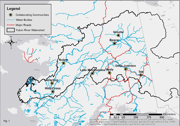
Figure 2. Location map showing the nine study areas (Cold et al., 2019 in review).
Nine rural communities within the Yukon River basin of Interior Alaska participated in the study. Longitude and latitude (NAD83) of each community, though subsistence activities took place in outlying areas:
Beaver (-147.3964, 66.3594), Delta Junction (-145.8422, 64.1525), Grayling (-160.0647, 62.9036), Healy (-149.1551, 63.8330), Holy Cross (-159.7714, 62.1994), Lake Minchumina (-152.3122, 64.8828)**, Nulato (-158.1031, 64.7194), Tok (-142.9856, 63.3367), and Venetie (-146.4186, 67.0139).
**Note: No photos were provided for Lake Minchumina and therefore no observations related to Lake Minchumina community are listed in Environmental_Disturbances_Alaska.csv
Community engagement
Individual communities were invited to partner with the study by way of community-wide informational meetings organized through local governing bodies within each community Communities were sought that perceived a local benefit from engagement. Recruitment efforts also were synchronized across the region to capture a broad representation of differences in resource use and landscape characteristics across Interior Alaska, and representation of communities both on and off the road system. Formal written approval (e.g., Tribal Resolution) from a representative community entity (e.g., Tribal Council, Fish and Game Local Advisory Committee) was obtained prior to beginning research. Each representative entity selected two to three residents (hereafter “harvesters”) within their community to participate as citizen scientists. Selected individual residents actively participated in subsistence and had in-depth experience and knowledge of traditional harvest areas around each community.
Researchers interviewed project participants in every collaborating community except Healy, as those individuals were unavailable for interviews during this part of the study. Interview questions followed a seasonal-calendar approach, discussing subsistence activities performed and environmental disturbances encountered during every season within an annual cycle. Questions targeted both information regarding environmental disturbances encountered during the time frame of the study (12-month period) and broader local ecological knowledge regarding how landscape and subsistence behaviors had changed over time.
Documentation of environmental conditions
Following protocols established by Brinkman et al. (2018), each harvester received a camera-equipped GPS unit to collect photos and spatial coordinates of environmental conditions affecting travel and access. Harvesters determined which conditions were important, rather than researchers. A purposefully open design reduced the possibility of bias in the documentation process. Photo dates and coordinates augmented with paper data recorded by harvesters insured accurate photo interpretation. Harvesters described the photograph, subsistence activity being conducted, how access to resources was affected, how frequently the condition has been observed, when the condition was first observed, how the condition affected travel safety, and to what spatial extent they witnessed this condition. Harvesters documented observations of environmental conditions affecting access for a 12-month period. As communities began participating on a rolling basis, data were collected from February 2016 through July of 2017. In some cases harvesters preferred to capture spatially and temporally explicit images using personal smartphones in lieu of the provided GPS units, and information collected via either method was identical (Cold et al., 2019 in review).
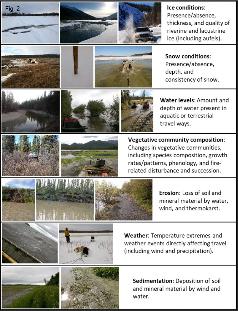
Figure 3. Descriptions and photographic examples of the seven categories developed by researchers of conditions associated with environmental changes (Cold et al., 2019 in review).
Researchers interviewed project participants in every collaborating community except Healy, as those individuals were unavailable for interviews during this part of the study. Interview questions followed a seasonal-calendar approach, discussing subsistence activities performed and environmental disturbances encountered during every season within an annual cycle. Questions targeted both information regarding environmental disturbances encountered during the time frame of the study (12-month period) and broader local ecological knowledge regarding how landscape and subsistence behaviors had changed over time. The semi-structured interviews were designed to complement and allow direct comparisons with the GPS unit approach.
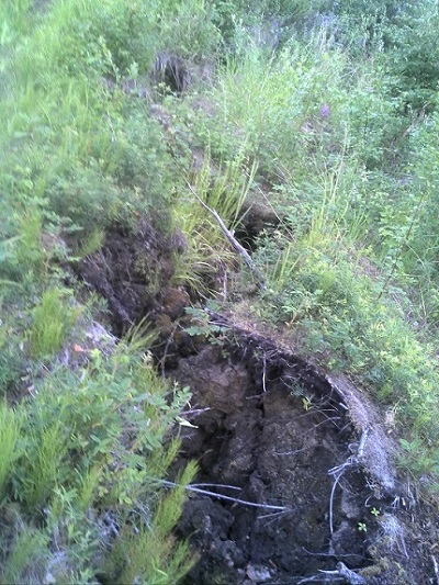
Figure 4. Permafrost thaw at fish camp in Kayu slough (photo from harvester "JT", photo # JT_07_03_16_2020A.jpg).
Sensitivity metric
A sensitivity metric was derived based on a 7-point scale that considered the implications of the condition encountered on the subsistence activity in which the harvester was engaged, and the effect that each condition had on harvester travel efficiency, safety, and the opportunity to harvest resources. This metric incorporated the adaptive capacity of individuals to environmental conditions, as their reporting included contextual information regarding their ability to adapt to stressors associated with each condition. Information used to develop the scale was extracted from responses to interview questions and data collected on GPS data forms (Cold et al., 2019 in review).
Data Access
These data are available through the Oak Ridge National Laboratory (ORNL) Distributed Active Archive Center (DAAC).
ABoVE: Environmental Conditions and Subsistence Resource Access, Alaska, 2016-2017
Contact for Data Center Access Information:
- E-mail: uso@daac.ornl.gov
- Telephone: +1 (865) 241-3952
References
Brinkman, T.J., D. Arnold, T. Stinchcomb, G. Kofinas, F. S. Chapin, III. 2018. Community research fatigue in the Arctic: seeking solutions. Frontiers in Ecology and the Environment (in review).
Cold, H. S., T. J. Brinkman, C. L. Brown, T. N. Hollingsworth, D. R. N. Brown, and K. M. Heeringa. 2020. Assessing vulnerability of subsistence travel to effects of environmental change in Interior Alaska. Ecology and Society 25(1):20.
https://doi.org/10.5751/ES-11426-250120
Magdanz, J. S., J. Greenberg, J. M. Little, and D. S. Koster. 2016. The Persistence of Subsistence: Wild Food Harvests in Rural Alaska, 1983-2013. http://doi.org/10.2139/ssrn.2779464
US Census Bureau. 2010. Annual Estimates of the Resident Population: April 1, 2005 to July 1, 2010. Suitland, MD: U.S. Census Bureau, Population Division. https://factfinder.census.gov.