Documentation Revision Date: 2019-07-19
Dataset Version: 1
Summary
For the past five years, through a variety of projects and collaborations, research infrastructure has been developed at a variety of sites around Fairbanks, Alaska. Investment will continue in these sites over the next ten years. The sites are road accessible and represent a variety of ecotype and terrain types common in the boreal biome of interior Alaska.
There is one data file in comma-separated (.csv) format with this dataset. The measurement locations are provided as two companion files, one in shapefile (.shp) format and one in.kmz format for viewing in Google Earth.
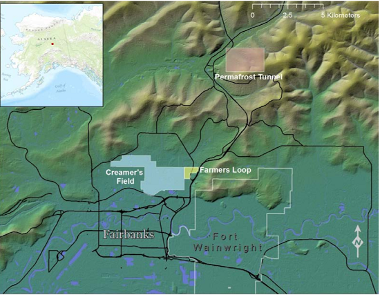
Figure 1. Locations of the Creamer's Field, Farmer's Loop, and Permafrost Tunnel transect sites (photo from Bjella et al., 2015).
Citation
Douglas, T.A., C.A. Hiemstra, and A.J. Barker. 2019. ABoVE: End of Season Snow Depth at CRREL sites near Fairbanks, Alaska, 2014-2019. ORNL DAAC, Oak Ridge, Tennessee, USA. https://doi.org/10.3334/ORNLDAAC/1702
Table of Contents
- Dataset Overview
- Data Characteristics
- Application and Derivation
- Quality Assessment
- Data Acquisition, Materials, and Methods
- Data Access
- References
Dataset Overview
This dataset provides 20,582 snow depth measurements collected at six sites near Fairbanks, Alaska, USA. Measurements were made during March or April from 2014-2019. The sites were located at or near Goldstream, Creamer's Field, APEX, the Permafrost Tunnel and Farmer's Loop. The US Army Corps of Engineers, Cold Regions Research and Engineering Laboratory (CRREL) owns and operates facilities at the Permafrost Tunnel and Farmer's Loop. The sites are suitable for manipulation experiments, installing permanent equipment, and establishing long-term measurements.
For the past five years, through a variety of projects and collaborations, research infrastructure has been developed at a variety of sites around Fairbanks, Alaska. Investment will continue in these sites over the next ten years. The sites are road accessible and represent a variety of ecotype and terrain types common in the boreal biome of interior Alaska.
Project: Arctic-Boreal Vulnerability Experiment
The Arctic-Boreal Vulnerability Experiment (ABoVE) is a NASA Terrestrial Ecology Program field campaign based in Alaska and western Canada between 2016 and 2021. Research for ABoVE links field-based, process-level studies with geospatial data products derived from airborne and satellite sensors, providing a foundation for improving the analysis and modeling capabilities needed to understand and predict ecosystem responses and societal implications.
Related Dataset:
Douglas, T.A. 2019. ABoVE: Soil Active Layer Thaw Depths at CRREL sites near Fairbanks, Alaska, 2014-2018. ORNL DAAC, Oak Ridge, Tennessee, USA. https://doi.org/10.3334/ORNLDAAC/1701
Data Characteristics
Spatial Coverage: Six sites near Fairbanks, Alaska
ABoVE Reference Locations
Domain: Core ABoVE
Grid cells: Ah1Av0.Bh6Bv5.Ch40Cv32; Ah1Av0.Bh6Bv5.Ch39Cv32
Spatial Resolution: Multiple points, measurements every 1 to 5 m along transects
Temporal Coverage: 2014-04-14 to 2019-03-07
Temporal Resolution: In 2014, the measurements were made in April. For 2015-2019, the measurements were made in March.
Study Area: All latitudes and longitudes given in decimal degrees
|
Site (Region) |
Westernmost Longitude |
Easternmost Longitude |
Northernmost Latitude |
Southernmost Latitude |
|---|---|---|---|---|
|
Fairbanks, AK |
-148.3323613 |
-147.611354 |
64.9591171 |
64.6938223 |
Data File Information
There is one data file in comma-separated format (.csv) and two companion files with this dataset. Not all transects were measured each year. See Section 5.
Table 1. File names and descriptions
|
File name |
Description |
|---|---|
|
end_season_snow_depth_six_sites_near_fairbanks.csv |
This data file provides 20,582 snow depth measurements made at six transects located near Fairbanks, Alaska during the period 2014 to 2019. Note the Coordinate Reference System: EPSG 26906 |
| Companion Files | |
|
end_of_season_snow_depth_all_sites.zip |
Companion file with the measurement locations in shapefile format (shp), provided as a compressed (.zip) file |
|
end_of_season_snow_depth_all_sites.kmz |
Companion file with the measurement locations in .kmz format for viewing in Google Earth |
Table 2. Variables in the data file end_season_snow_depth_six_sites_near_fairbanks.csv
|
Column |
Units |
Description |
|
date |
yyyy-mm-dd |
Approximate date of the measurement |
|
site |
|
Transect site |
|
northing |
m |
Northing location of measurement, NAD83 / UTM zone 6N |
|
easting |
m |
Easting location of measurement, NAD83 / UTM zone 6N |
|
latitude |
decimal degrees |
Latitude of measurement location |
|
longitude |
decimal degrees |
Longitude of measurement location |
|
snow_depth |
cm |
Snow depth |
Application and Derivation
The goal of collecting the snow depth measurements is to accumulate a long-term record of snow depth in the area.
Quality Assessment
None provided.
Data Acquisition, Materials, and Methods
Snow depth was measured at six transects near Fairbanks, Alaska: APEX Transects 1 and 2, Creamer’s Field (a migratory waterfowl refuge owned by the state of Alaska), Farmer’s Loop, the Permafrost Tunnel (CRREL owns and operates facilities at the Permafrost Tunnel and Farmer’s Loop), and Goldstream. The transects are 400 to 500-m long. Sites are road accessible and represent a variety of ecotype and terrain types which vary along the transects and site to site.
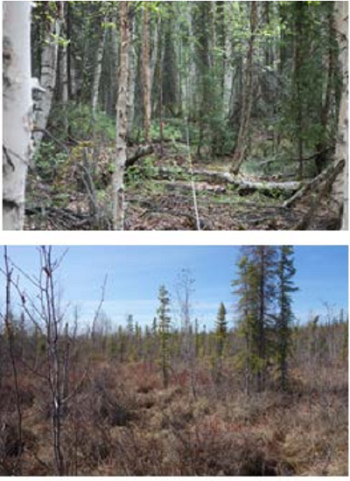
Figure 2. Vegetation along the Farmer’s Loop transects. The top photo is at 40 m along the transect, the bottom photo shows vegetation at 200 m (photo from Bjella et al., 2015).
Measurements were made along each transect every 1-5m using a Magnaprobe (Snow-Hydro, Fairbanks, Alaska) and a Trimble GPS.
Not all transects were measured each year.
In 2014, measurements were made at the Creamer’s Field, Farmer’s Loop, and Permafrost Tunnel transects.
In 2015, measurements were made at all transects except Goldstream.
In 2016, 2017, and 2018, measurements were made at each of the six transects.
In 2019, measurements were made at the Permafrost Tunnel and Farmers Loop transects.
Data Access
These data are available through the Oak Ridge National Laboratory (ORNL) Distributed Active Archive Center (DAAC).
ABoVE: End of Season Snow Depth at CRREL sites near Fairbanks, Alaska, 2014-2019
Contact for Data Center Access Information:
- E-mail: uso@daac.ornl.gov
- Telephone: +1 (865) 241-3952
References
Bjella, K., S. Arcone, and T. Douglas. Imaging of Ground Ice with Surface-Based Geophysics Cold Regions Research and Engineering Laboratory. 2015. Technical Report. ERDC/CRREL TR-15-14. Available at https://erdc-library.erdc.dren.mil/xmlui/bitstream/handle/11681/5504/ERDC-CRREL-TR-15-14.pdf