Documentation Revision Date: 2018-09-24
Data Set Version: 1
Summary
Sheep survey data originated from state and federal monitoring surveys. Raw sheep counts were not comparable across surveys therefore the ratio of lambs per 'ewe-like' sheep was calculated and used as an indicator of recruitment. Daily snow extent was estimated using MODIS imagery. Distance to the center of the Dall sheep range, latitude, longitude, and elevation were estimated from the Global Multi-resolution Terrain Elevation Data 2010 produced by the United States Geological Survey, and monthly gridded climate products were estimated from the Scenarios Network for Alaska + Arctic Planning (SNAP).
There are two data files in this dataset: one file in comma-separated format with the sheep survey and covariate data, and one shapefile (.shp) provided as a compressed .zip file, with mountain unit locations.
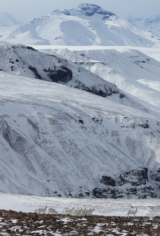
Figure 1. A herd of Dall sheep ewes and lambs are dwarfed by the mountainous landscape in Wrangell St. Elias National Park, Alaska, March 2017. Photo credit: Laura Prugh.
Citation
van de Kerk, M., D. Verbyla, A.W. Nolin, K.J. Sivy, and L.R. Prugh. 2018. ABoVE: Dall Sheep Lamb Recruitment and Climate Data, Alaska and NW Canada, 2000-2015. ORNL DAAC, Oak Ridge, Tennessee, USA. https://doi.org/10.3334/ORNLDAAC/1640
Table of Contents
- Data Set Overview
- Data Characteristics
- Application and Derivation
- Quality Assessment
- Data Acquisition, Materials, and Methods
- Data Access
- References
Data Set Overview
This dataset contains estimated annual average Dall sheep (Ovis dalli dalli) lamb-to-ewe ratios for each year from 2000-2015 across the full species range in Alaska and Northwestern Canada. Sheep population data are from surveys conducted over the 14 major mountain ranges encompassing the range of Dall sheep. For this study, the mountain ranges were divided into 24 mountain units due to differing climate gradients. Estimated covariate environmental and climate data used to examine the relationship between environmental conditions and Dall sheep population performance (per mountain unit) are also provided and include precipitation, temperature, snow cover, elevation, and distance to the center of the range.
Sheep survey data originated from state and federal monitoring surveys. Raw sheep counts were not comparable across surveys therefore the ratio of lambs per 'ewe-like' sheep was calculated and used as an indicator of recruitment. Daily snow extent was estimated using MODIS imagery. Distance to the center of the Dall sheep range, latitude, longitude, and elevation were estimated from the Global Multi-resolution Terrain Elevation Data 2010 produced by the United States Geological Survey, and monthly gridded climate products were estimated from the Scenarios Network for Alaska + Arctic Planning (SNAP).
Project: Arctic-Boreal Vulnerability Experiment
The Arctic-Boreal Vulnerability Experiment (ABoVE) is a NASA Terrestrial Ecology Program field campaign based in Alaska and western Canada between 2016 and 2021. Research for ABoVE links field-based, process-level studies with geospatial data products derived from airborne and satellite sensors, providing a foundation for improving the analysis and modeling capabilities needed to understand and predict ecosystem responses and societal implications.
Related Datasets:
Mahoney, P., G. Liston, B. Mangipane, and L.R. Prugh. 2018. ABoVE: Dall Sheep Response to Snow and Landscape Covariates, Alaska, 2005-2008. ORNL DAAC, Oak Ridge, Tennessee, USA. https://doi.org/10.3334/ORNLDAAC/1602
Sivy, K.J., A.W. Nolin, C.L. Cosgrove, and L.R. Prugh. 2018. ABoVE: Dall Sheep Track Sinking Depths, Snow Depth, Hardness, and Density, 2017. ORNL DAAC, Oak Ridge, Tennessee, USA. https://doi.org/10.3334/ORNLDAAC/1583
Related Publication:
van de Kerk, M., D. Verbyla, A.W. Nolin, K.J. Sivy, and L.R. Prugh. 2018. Range-wide variation in the effect of spring snow phenology on Dall sheep population dynamics. Environ. Res. Lett(13),7. https://doi.org/10.1088/1748-9326/aace64
Acknowledgments:
This research was funded by NASA ABoVE grants NNX15AU21A, NNX15AV86A, and NNX15AU13A.
Data Characteristics
Spatial Coverage: Dall sheep range in Alaska and northwest Canada
ABoVE Reference Locations:
Domain: Core ABoVE
ABoVE Grid cells:
| Ah0Av0Bh6Bv2 | Ah0Av0Bh4Bv5 | Ah0Av0Bh5Bv5 | Ah0Av1Bh3Bv6 |
| Ah0Av1Bh4Bv6 | h0Av1Bh4Bv7 | Ah0Av1Bh5Bv6 | Ah0Av1Bh5Bv7 |
| Ah1Av0Bh6Bv2 | Ah1Av0Bh6Bv3 | Ah1Av0Bh6Bv4 | Ah1Av0Bh7Bv3 |
| Ah1Av0Bh8Bv3 | Ah1Av0Bh8Bv4 | Ah1Av0Bh9Bv4 | Ah1Av0Bh10Bv5 |
| Ah1Av1Bh6Bv6 | Ah1Av1Bh6Bv7 | Ah1Av1Bh6Bv8 | Ah1Av1Bh6Bv9 |
| Ah1Av1Bh7Bv8 | Ah1Av1Bh7Bv9 | Ah1Av1Bh8Bv6 | Ah1Av1Bh8Bv7 |
| Ah1Av1Bh9Bv6 | Ah1Av1Bh9Bv7 | Ah1Av1Bh10Bv9 |
Spatial resolution: Multiple points
Temporal coverage: 2000-01-01 - 2015-12-31
Temporal resolution: Annual
Study Areas (All latitude and longitude given in decimal degrees)
| Site | Westernmost Longitude | Easternmost Longitude | Northernmost Latitude | Southernmost Latitude |
|---|---|---|---|---|
| Dall sheep range, Alaska and northwest Canada | -163.281 | -123.547 | 69.70735 | 59.59776 |
Data File Information
There is one data file in comma-separated (.csv) format and one shapefile (.shp) provided as a compressed .zip file. The shapefile is also provided as a .kmz for viewing in Google Earth.
Table 1. File names.
| File name | Description |
|---|---|
| lamb_ewe_ratios_by_mountainunit.csv | This file provides the sheep survey and covariate data |
| mountainunits.zip | This compressed file contains a shapefile (.shp) with data for 24 polygons representing the mountain range units. |
| Companion file | |
| mountainunits.kmz | The shapefile data in .kmz format for viewing in Google Earth |
Table 2. Variables in the file lamb_ewe_ratios_by_mountainunit.csv.
| Column name | Units/format | Description |
|---|---|---|
| mountain_unit | There were 14 mountain ranges divided into 24 mountain units for the study | |
| year | YYYY | Year |
| lamb_ewe_ratio | ratio | Average lamb-to-ewe ratio |
| surveys | Number of surveys | |
| elevation | m | Mean mountain unit elevation |
| snow_line_elevation | m | Snowline elevation on May 15 |
| snow_disappearance | DOY | Snow disappearance day of year mean |
| snow_cover_duration | days | Snow cover duration mean |
| temp | degrees C | Annual average temperature for that year |
| precip | mm | Total annual precipitation for that year |
| may_temp | degrees C | Average temperature in May for that year |
| winter_precip | mm | Total winter (October–April) precipitation preceeding lambing season in that year |
| latitude | decimal degrees | Mean mountain unit latitude |
| longitude | decimal degrees | Mean mountain unit longitude |
| distance | km | The distance from the center point of each mountain unit to the range center |
| density | adult sheep/km2 | Sheep density was calculated by dividing the number of adult sheep in an area by the survey area. Note that the survey area was not always known. There are numerous missing values (-9999). |
Shapefile information
The shapefile contains the following data for 24 polygons representing the mountain units.
Table 3. Variables in the shapefile mountainunits.shp (and .kmz companion file).
| Name | Mountain unit name, e.g. “AK Range Central North Slope” |
| Hectares | Area of polygon |
| Label | Alphabetical (A through X) |
Table 4. Mountain range units.
| A = Western Brooks North Slope |
| B = Central Brooks North Slope |
| C = Eastern Brooks North Slope |
| D = Western Brooks South Slope |
| E = Central Brooks South Slope |
| F = Eastern Brooks South Slope |
| G = Richardson Mountains |
| H = Ogilvie Mountains |
| I = Tanana Uplands |
| J = Mackenzie Mountains |
| K = Central Alaska Range North Slope |
| L = Eastern Alaska Range North Slope |
| M = Central Alaska Range South Slope |
| N = Western Alaska Range North Slope |
| O = Eastern Alaska Range South Slope |
| P = Western Alaska Range South Slope |
| Q = Kluane Mountains |
| R = Ruby Range |
| S = Talkeetna Mountains |
| T = Chugach Mountains |
| U = Kenai Mountains |
| V = North Wrangell Mountains |
| W = South Wrangell Mountains |
| X = Coast Mountains |
Application and Derivation
In wildlife population studies, the impacts of changing Arctic snowpacks are not well understood. Dall sheep (Ovis dalli dalli) inhabit northern alpine ecosystems, which may be especially sensitive to environmental change because they occur at both high elevations and high latitudes. Knowing whether the relationships between climate factors and population performance are spatially consistent or variable is critical for improving predictions of climate-induced range shifts.
Quality Assessment
Sheep count and composition data originated from state and federal monitoring surveys, and consisted of 127, 833 records of sheep sightings from 1,570 surveys conducted over a 634, 271 km2 area. Raw sheep counts were not comparable across surveys due to differences in survey methods, locations, and areas. Therefore, the ratio of lambs per 'ewe-like' sheep was used as an indicator of recruitment.
Data Acquisition, Materials, and Methods
Dall sheep are endemic to northern alpine ecosystems in Alaska and northwestern Canada and require open, rugged terrain to forage efficiently and to provide for detection and evasion of predators. They require year-round access to forage and generally occupy areas between 900 m and 2100 m in elevation. Sheep survey data used in this study originated from 14 major mountain ranges, encompassing the global distribution of Dall sheep. The Dall sheep range was divided into 24 mountain units (Figure 2 and Table 4) (van de Kerk et al., 2018).

Figure 2. The study domain in Alaska and northwestern Canada, depicting survey units (red outlines) across the global range of Dall sheep (shaded grey areas) (van de Kerk et al., 2018).
Survey Data
Sheep survey data collected during 2000–2015 were obtained throughout Alaska and Canada from Alaska Department of Fish and Game, National Park Service, Parks Canada, Environment Yukon, and Government of Northwest Territories. Sheep count and composition data originated from state and federal monitoring surveys, and consisted of 127, 833 records of sheep sightings from 1,570 surveys conducted over a 634, 271 km2 area. The surveys were mostly performed during summer using aircraft. Raw sheep counts were not comparable across surveys due to differences in survey methods, locations, and areas. Therefore, the ratio of lambs per 'ewe-like' sheep was used as an indicator of recruitment.
Covariates
Daily snow cover extent was estimated from April through July. The MODIS snow covered-area and grain size (MODSCAG) product was used to estimate the fraction of each 500-m pixel that was covered by snow (Painter et al., 2009).
For each pixel, the annual first date without snow cover was estimated and the annual snow disappearance date (SDD) for each mountain unit was calculated by averaging over all the pixels within the unit. The mean SDD was computed for each 100 m elevation zone and linear regression (all R2 values >0.95) was used to estimate the snowline elevation for each mountain unit as a function of the day of the year. The regression equations were then used to estimate the annual snowline elevation on May 15 (SLE), since lambing typically occurs mid-May.
The number of days each year, from August through July, during which snow cover was observed in each pixel was calculated using the 500 m MODIS daily snow cover data (MOD10A1 v6) to evaluate the effect of snow cover duration (SCD) on Dall sheep. The mean of all pixel-level snow duration values was computed within each mountain unit. Cloudy pixels were counted as snow-covered if days before and after were snow-covered.
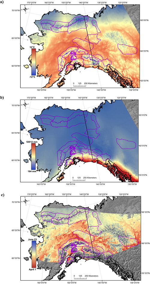
Figure 3. The average (a) May temperature, (b) total winter precipitation, and (c) snow disappearance date (SDD) over the entire study period, 2000–2015 (van de Kerk et al., 2018).
In addition to the three snow cover variables (SDD, SLE, and SCD), for each mountain unit, the distance to the center of the Dall sheep range, mean latitude, mean longitude, and mean elevation were estimated from the Global Multi-resolution Terrain Elevation Data 2010 produced by the United States Geological Survey. Monthly gridded climate products from the Scenarios Network for Alaska + Arctic Planning (SNAP) were used to estimate average annual temperature, average May temperature, total annual precipitation, and total winter (October–April) precipitation. Annual average lamb-to-ewe ratios were calculated for each mountain unit for 2000–2015. The number of surveys per mountain unit for each year was used as a weighting factor in the models to account for the different number of surveys aggregated per data point (van de Kerk et al., 2018).
Data Access
These data are available through the Oak Ridge National Laboratory (ORNL) Distributed Active Archive Center (DAAC).
ABoVE: Dall Sheep Lamb Recruitment and Climate Data, Alaska and NW Canada, 2000-2015
Contact for Data Center Access Information:
- E-mail: uso@daac.ornl.gov
- Telephone: +1 (865) 241-3952
References
Painter, T.H., K. Rittger, C. McKenzie, P. Slaughter, R.E. Davis, and J. Dozier. 2009. Retrieval of subpixel snow covered area, grain size, and albedo from MODIS. Remote Sens. Environ. 113 868–79 https://doi.org/10.1016/j.rse.2009.01.001
van de Kerk, M., D. Verbyla, A.W. Nolin, K.J. Sivy, and L.R. Prugh. 2018. Range-wide variation in the effect of spring snow phenology on Dall sheep population dynamics. Environ. Res. Lett(13),7. https://doi.org/10.1088/1748-9326/aace64