Documentation Revision Date: 2018-12-31
Data Set Version: 1
Summary
The plots were subjectively located in 14 broad plant communities and six broad habitat types. Topographically, the two areas were dissimilar, but had similar environmental conditions and plant community types.
There are two data files with this dataset in comma-separated (.csv) format.
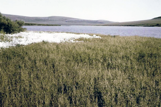
Figure 1. Lake shore vegetation at Canoe Lake. In the foreground is Arctophiletum fulvae, bordered by a band of Eriophorum scheuchzeri. The cut bank supports Salix pulchra. Photo from Lambert (1968).
Citation
Lambert, J.D.H. 2018. Arctic Vegetation Plots in Northern NWT and YT, Canada, 1965-1966. ORNL DAAC, Oak Ridge, Tennessee, USA. https://doi.org/10.3334/ORNLDAAC/1543
Table of Contents
- Data Set Overview
- Data Characteristics
- Application and Derivation
- Quality Assessment
- Data Acquisition, Materials, and Methods
- Data Access
- References
Data Set Overview
This dataset provides vegetation, soil, and plot characteristics for 154 study plots located at three sites across the Richardson Mountains, Northwest Territories (NWT), and the British Mountains, Yukon Territory (YT). Study sites in the NWT included areas near Canoe Lake and Divided Lake; the study site in the YT was near Trout Lake. Specific attributes include dominant vegetation, species cover, and the physical characteristics of the plot areas. A soil pit was dug at each plot and the physical and chemical characteristics were determined for soil horizons. The data were collected in June, July, and August of 1965 and July and August of 1966. The Plots were subjectively located in 14 broad plant communities and six broad habitat types. Topographically, the two areas were dissimilar, but had similar environmental conditions and plant community types.
The Pre-ABoVE vegetation plot datasets were curated to create the Alaska Arctic Vegetation Archive (AVA-AK; Walker et al. 2016b, Walker 2013). The AVA-AK is a regional database that is part of the larger Arctic Vegetation Archive (Walker 2016a, Walker et al. 2013, Walker and Raynolds 2011). The database contains vegetation plots from homogeneous plant communities with tables of cover or cover-abundance scores for all species and accompanying environmental site data. Field data were collected using Braun-Blanquet, US National Vegetation Classification protocols, or comparable methods.
Project: Arctic-Boreal Vulnerability Experiment (ABoVE)
The Arctic-Boreal Vulnerability Experiment (ABoVE) iis a NASA Terrestrial Ecology Program field campaign that will take place in Alaska and western Canada between 2016 and 2021. Climate change in the Arctic and Boreal region is unfolding faster than anywhere else on Earth. ABoVE seeks a better understanding of the vulnerability and resilience of ecosystems and society to this changing environment.
Acknowledgements:
These data files were edited by Donald A. Walker, Amy L. Breen and Lisa A. Druckenmiller at the University of Alaska Fairbanks' Alaska Geobotany Center and obtained via the Arctic Geoecological Atlas (http://arcticatlas.geobotany.org/), which provides access to existing Arctic vegetation plot and map data in support of the ABoVE campaign.
Data Characteristics
Spatial Coverage: Canoe Lake and Divided Lake in the Richardson Mountains, Northwest Territories, and Trout Lake in the British Mountains, Yukon Territory
ABoVE Grid Location: Ahh1Avv0Bh4Bv5
Spatial Resolution: Point resolution
Temporal Coverage: 1965-06-09 to 1966-08-13
Temporal Resolution: Each plot was visited only once
Study Area (All latitude and longitude given in decimal degrees)
| Site | Westernmost Longitude | Easternmost Longitude | Northernmost Latitude | Southernmost Latitude |
|---|---|---|---|---|
| Canoe Lake and Divided Lake in the Richardson Mountains, Northwest Territories, and Trout Lake in the British Mountains, Yukon Territory | -138.748 | -135.697 | 68.82445 | 68.22028 |
Data File Information: There are two data files with this dataset in comma-separated (.csv) format.
Table 1. Data files
| Data File Name | Descriptions |
|---|---|
| Canadian_West_Arctic_Species_Data.csv | The estimated percent land cover by species per plot |
| Canadian_West_Arctic_Environmental_Data.csv | Comprehensive set of environmental characterization data |
Data Descriptions: The column names, their units and descriptions for each of the *.csv data files are listed below.
Table 2. Variables in the data file Canadian_West_Arctic_Species_Data.csv
These files contain species cover data for the vegetation plots. Both the author's determination and the current taxonomy according to the Panarctic Species List (PASL) are listed. Taxa are listed in alphabetical order according to the accepted PASL name. The data accession numbers from the Turboveg database are also included.
| Column number | Column header | Description |
|---|---|---|
| 1 | PASL_taxon_scientific_name | Current nomenclature according to the Panarctic Species List (PASL) |
| 2 | PASL_taxon_scientific_name_author | Current nomenclature according to the Panarctic Species List (PASL) with the data authors name |
| 3 | dataset_taxon | Dataset taxonomy |
| 4-156 | TURBOVEG_plot_accession_number and dataset_plot_number_author |
Two rows of column headers which are plot numbers/accession numbers. The first row is TURBOVEG accession numbers. Column headers for TURBOVEG accession numbers: 3001-3154. The 2nd row is dataset_plot_number_author, column headers are 1-182. The species cover classes follow the Braun-Blanquet (BB) scale: r = rare + = common, but less than 1 percent cover 1 = 1 to 5 percent 2 = 6 to 25 percent 3 = 25 to 50 percent 4 = 51 to 75 percent 5 = 76 to 100 percent |
Data file note: In four instances, taxa were lumped into a single taxon in the PASL: 1) Bryum pseudotriquetrum (Bryum bimum and Bryum pseudotriquetrum), 2) Calliergon trifarium (Calliergon trifarium and Psuedocalliergon trifarium), 3) Carex riishirensis (Carex montanensis and Carex podocarpa), and 4) Pohlia nutans (Pohlia nutans and Pohlia rutilans).
Table 3. Variables in the data file Canadian_West_Arctic_Environmental_Data.csv
| Column number | Variable | Units/format | Description |
|---|---|---|---|
| 1 | date | yyyymmdd | Date plot was investigated |
| 2 | plot_id | numeric | Plot number as provided by the author |
| 3 | locality | Site location: Canoe Lake, Divided Lake, or Trout Lake | |
| 4 | longitude | Longitude of plot. Georeference of general study areas at Canoe Lake, Divided Lake, and Trout Lake provided from Google Earth | |
| 5 | latitude | Latitude of plot. Georeference of general study areas at Canoe Lake, Divided Lake, and Trout Lake provided from Google Earth | |
| 6 | plot_area | m2 | Area of the plots |
| 7 | elevation | m | Elevation |
| 8 | slope_gradient | degrees | Plot slope- the average inclination of the ground surface from the horizontal plane |
| 9 | exposure | degrees | The topographic position of the plot in relation to a particular cardinal point |
| 10 | land_form | Describes the old land surface topography | |
| 11 | relief_profile | A profile of the surface shape of the sample plot (concave, convex, hummocky, flat) | |
| 12 | duration_snow | months | An estimate of the snow duration from observations. The length of time between snowfall remaining in the fall and complete melt from the plot surface in late spring or anytime during the summer |
| 13 | soil_drainage | Soil drainage observations (well drained, poor, impeded. moderate) | |
| 14 | soil_hygrotope | The moisture regime status of the plots studied in the Low Arctic Sub-alpine/Foothill Zone. Refers to hygrotope classes. Refer to the companion file Canadian_WestArctic_Lambert_1968.pdf provided with this dataset for additional information on the classes | |
| 15 | thaw_depth | cm | Thaw depth (active layer depth) |
| 16 | ph_organic layer | pH of the soil organic layer | |
| 17 | ph_organic_mineral_layer | pH of the soil organic mineral layer | |
| 18 | ph_mineral_layer | pH of the soil mineral layer | |
| 19 | plant_association | Plants associated with soils and habitat | |
| 20 | cover_mosses | % | Percent of mosses in the plant community |
| 21 | cover_lichen | % | Percent of plot that was lichen |
| 22 | cover_rock | % | Percent of plot that was rock |
| 23 | cover_water | % | Percent of plot that was open water |
Data User Note: Additional soil chemistry data are available in Lambert (1968) that is provided as a companion file.
Companion Files: There are two companion files with this dataset in .pdf format.
Table 4. Companion files
| File name | Description |
|---|---|
|
Canadian_West_Arctic_Lambert_1968.pdf |
A report providing detailed information of the study by J. Lambert, 1968 |
|
Canadian_West_Arctic_Plot_Photos.pdf |
Photos of the study areas by J. Lambert, 1968 |
Application and Derivation
These data and information could be useful to climate change studies.
Quality Assessment
Refer to the companion file Canadian_West_Arctic_Lambert_1968.pdf for quality assurance information.
Data Acquisition, Materials, and Methods
Site description
The study sites included Canoe Lake and Divided Lake in the Richardson Mountains, Northwest Territories, and Trout Lake in the British Mountains, Yukon Territory, in the subalpine/foothill zone in northern Canada. The area is 10 to 110 miles wide, being narrow in front of the British and Richardson Mountains and extending inland.
The topography at Trout Lake is very irregular. The lake is three miles long and half a mile wide, and lies in a shallow basin formed by shale erosion. The area has a closed system pingo, low-centered polygons around the pingo, and tundra mudflow. The terrain around Trout Lake is more regular than Canoe Lake and is related to the homogeneity of the bedrock. The more elevated areas are dry with only sparse vegetation. West of the lake are low-centered polygons. Topographically, the two areas are dissimilar, but the environmental conditions and majority of plant community types are similar and common to both (Lambert, 1968).
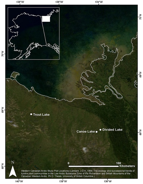
Figure 2. Location map of the study sites.
Plot characterization
Vegetation plot data were collected in June, July, and August of 1965 and July and August of 1966. One hundred fifty-four plots were subjectively located across the study areas. Depending on the vegetation type, sample plots varied between 16, 25 and 100 square meters. Sample plots were not permanently marked.
Plots were located in 14 broad plant communities and six broad habitat types including:
(1) willow shrub vegetation of riparian areas and warm habitats (13 plots),
(2) sedge grass and dwarf shrub mire and fen vegetation (27 plots),
(3) bog vegetation, acidic mires including tussock tundra (32 plots),
( 4) deep snowbed vegetation (20 plot),
(5) dry to moist dwarf-shrub heath and low shrub vegetation on acidic nutrient poor substrates (48 plots), and
(6) dry and mesic dwarf-shrub and graminoid vegetation on non-acidic substrates (14 plots).
The cover of vascular and nonvascular plant species was originally recorded according to the cover abundance scale developed by Krajina (1933). For the Turboveg database, the original species cover classes were converted to follow the old Braun-Blanquet (BB) scale as listed in Table 2. Plant cover by percent is also recorded in the environmental data file.
Table 7. The cover abundance scale developed by Krajina (1933) and originally used by the author:
| 1 = sporadic |
| 2 = 0 to 1 percent |
| 3 = 1 to 5 percent |
| 4 = 5 to 10 percent |
| 5 = 10 to 25 percent |
| 6 = 25 to 33 percent |
| 7 = 33 to 50 percent |
| 8 = 50 to 75 percent |
| 9 = 75 to 99 percent |
| 10 = 100 percent |
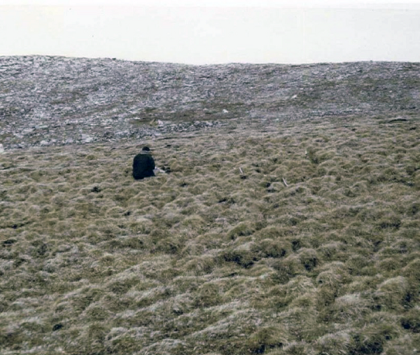
Figure 3. Study site vegetation: Betulo-Eriphoretum vaginati (salicetosum reticulatae) (Photo from Lambert, 1968).
Soil characterization
A soil pit was dug at each study plot. This dataset provides the pH and drainage observations. In addition, thaw depth (the depth of the active layer) was recorded for most study plots. For additional information regarding soil data, refer to the companion file Canadian_West_Arctic_Lambert_1968.pdf provided with this dataset.
Data Access
These data are available through the Oak Ridge National Laboratory (ORNL) Distributed Active Archive Center (DAAC).
Arctic Vegetation Plots in Northern NWT and YT, Canada, 1965-1966
Contact for Data Center Access Information:
- E-mail: uso@daac.ornl.gov
- Telephone: +1 (865) 241-3952
References
Krajina, V. 1933. Die Pflanzengesellschaften des Mlynica-Tales in den Vysoké Tatry. Beih. Bot. Cbl., Dresden 50: 1–224.
Lambert, J.D.H. 1968. The ecology and successional trends of tundra plant communities in the Low Arctic Subalpine Zone of the Richardson and British Mountains of the Canadian Western Arctic. Ph.D. thesis. University of British Columbia, Canada.
Walker, D.A., Daniëls, F.J.A., Alsos, I., Bhatt, U.S., Breen, A.L., Buchhorn, M., Bültmann, H., Druckenmiller, L.A., Edwards, M.E., Ehrich, D. and Epstein, H.E., 2016. Circumpolar Arctic vegetation: a hierarchic review and roadmap toward an internationally consistent approach to survey, archive and classify tundra plot data. Environmental Research Letters, 11(5), p.055005. https://doi.org/10.1088/1748-9326/11/5/055005
Walker, D. A.; A. L. Breen; L. A. Druckenmiller; L. W. Wirth; W. Fisher; M. K. Raynolds; J. Šibík; M. D. Walker; S. Hennekens; K. Boggs; T. Boucher; M. Buchhorn; H. Bültmann; D. J. Cooper; F. J.A Daniëls; S. J. Davidson; J. J. Ebersole; S. C. Elmendorf; H. E. Epstein; W. A. Gould; R. D. Hollister; C. M. Iversen; M.T. Jorgenson; A. Kade; M. T. Lee; W. H. MacKenzie; R. K. Peet; J. L. Peirce; U. Schickhoff; V. L. Sloan; S. S. Talbot; C. E. Tweedie; S. Villarreal; P. J. Webber; D. Zona. The Alaska Arctic Vegetation Archive. 2016b. https://doi.org/10.1127/phyto/2016/0128
Walker, D.A. (Ed). Alaska Arctic Vegetation Archive Workshop, Boulder, Colorado, October 14-16, 2013. CAFF Proceedings Report #11. Akureyri, Iceland. ISBN: 978-9935-431-29-5.
Walker, D. A., A. L. Breen, M. K. Raynolds, and M. D. Walker, editors. 2013. Arctic Vegetation Archive Workshop, Krakow, Poland April 14-16, 2013. CAFF Proceedings Report #10. Akureyri, Iceland. ISBN: 978-9935-431-24-0.
Walker, D. A., and M. K. Raynolds. 2011. An International Arctic Vegetation Database: A foundation for panarctic biodiversity studies. CAFF Strategy Series Report nr. 5. Conservation of Arctic Flora and Fauna (CAFF), Akureyri, Iceland.