Documentation Revision Date: 2024-03-19
Dataset Version: 1
Summary
There are three files in GeoTIFF format and two shapefiles with this dataset.
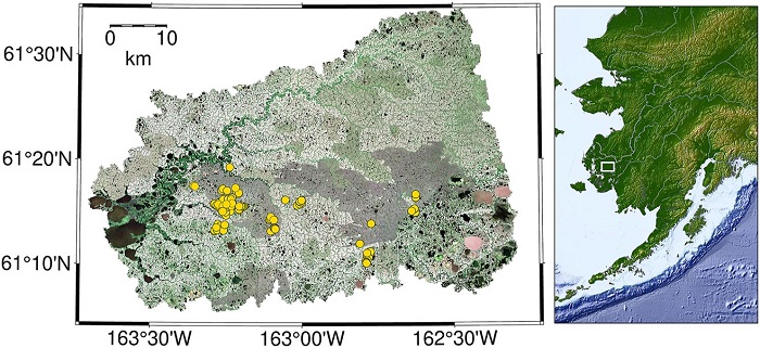
Figure 1. Study area in the Yukon Kuskokwim Delta of Alaska (left) with regional context (right). Sentinel-2 10 m resolution RGB imagery of the study region (left). Surface water sample locations from 2016 to 2019 are depicted as yellow points. Source: Ludwig et al. (2022).
Citation
Ludwig, S., S. Natali, J. Schade, M. Powell, G. Fiske, L.D. Schiferl, and R. Commane. 2023. CO2 and CH4 Fluxes from Waterbodies, Yukon-Kuskokwim Delta, Alaska, 2016-2019. ORNL DAAC, Oak Ridge, Tennessee, USA. https://doi.org/10.3334/ORNLDAAC/2178
Table of Contents
- Dataset Overview
- Data Characteristics
- Application and Derivation
- Quality Assessment
- Data Acquisition, Materials, and Methods
- Data Access
- References
Dataset Overview
This dataset provides estimates of carbon dioxide (CO2) and methane (CH4) diffusive fluxes from waterbodies, and watershed landcover data for the central-interior of the Yukon-Kuskokwim Delta (YK delta), Alaska. Dissolved concentrations of methane and carbon dioxide were predicted using an integrated terrestrial-aquatic approach to scale observations based on landscape and waterbody remote sensing drivers. The observations include ~300 samples of surface water dissolved gases collected in July 2016-2019 from the central region of the YK Delta, Alaska. A machine learning model was used to generate estimated fluxes. Model inputs include Sentinel-2 MSI with derived normalized difference vegetation index (NDVI) and normalized difference water index (NDWI), an Arctic digital elevation model (DEM) with derived slope and flow accumulation, Sentinel-1 C-band July and December VV and VH composites, and a landcover map. Waterbody size, shape, and reflectance were determined using object-based image analysis in Google Earth Engine. Landscape-level input data were averaged in non-nested sub-basins calculated using the System for Automated Geoscientific Analyses (SAGA) "channel network" algorithm at three threshold sizes. Cross validation was used to tune and select variables for gradient boosting models. The trained gradient boosting models were then used to predict dissolved methane and carbon dioxide in all waterbodies (~17,000) in the region. These aquatic concentrations were converted to fluxes using an average gas transfer velocity from observations (0.33 m/d).
Project: Arctic-Boreal Vulnerability Experiment
The Arctic-Boreal Vulnerability Experiment (ABoVE) is a NASA Terrestrial Ecology Program field campaign being conducted in Alaska and western Canada, for 8 to 10 years, starting in 2015. Research for ABoVE links field-based, process-level studies with geospatial data products derived from airborne and satellite sensors, providing a foundation for improving the analysis, and modeling capabilities needed to understand and predict ecosystem responses to, and societal implications of, climate change in the Arctic and Boreal regions.
Related Publications
Ludwig, S.M., S. M. Natali, P.J. Mann, J.D. Schade, R.M.Holmes, M. Powell, G.Fiske, and R. Commane. 2022. Using machine learning to predict inland aquatic CO2 and CH4 concentrations and the effects of wildfires in the Yukon-Kuskokwim Delta, Alaska. Global Biogeochemical Cycles 36:e2021GB007146. https://doi.org/10.1029/2021GB007146
Ludwig, S.M., S.M. Natali, J.D. Schade, M. Powell, G. Fiske, L.D. Schiferl, and R. Commane. 2023. Scaling waterbody carbon dioxide and methane fluxes in the arctic using an integrated terrestrial-aquatic approach. Environmental Research Letters 18:064019. https://doi.org/10.1088/1748-9326/acd467
Acknowledgements
This study was supported by NASA's Arctic-Boreal Vulnerability Experiment (ABoVE) program (FINESST 2019, grant 80NSSC19K1301).
Data Characteristics
Spatial Coverage: Yukon-Kuskokwim Delta, Alaska
ABoVE Reference Locations
Domain: Core ABoVE
State/Territory: Alaska
Grid cells: Ah000v000, Bh001v003, Bh002v003, Ch011v021, Ch012v020, Ch012v021, Ch012v022, Ch013v020, Ch013v021,
Ch013v022, Ch013v023, Ch014v019, Ch014v020, Ch014v021, Ch014v022, Ch014v023, Ch015v020, Ch015v021,
Ch015v022, Ch015v023, Ch016v022
Spatial Resolution: 0.00009 degrees (~10 m)
Temporal Coverage: 2016-07-07 to 2019-07-07
Temporal Resolution: One time estimates
Study Area: Latitude and longitude are given in decimal degrees.
| Site | Westernmost Longitude | Easternmost Longitude | Northernmost Latitude | Southernmost Latitude |
|---|---|---|---|---|
| southwestern Alaska | -163.820 | -162.073 | 61.678 | 60.895 |
Data File Information
There are three files in GeoTIFF (.tif) format and two shapefiles in compressed Zip archives (*.zip).
GeoTIFF files
- CH4_flux_YKD.tif: methane flux in mg m-3 d-1
- CO2_flux_YKD.tif: carbon dioxide flux in mg m-3 d-1
- YKD_landcover.tif: land cover map for the study region (see Table 1).
GeoTIFF characteristics:
- Coordinate system: geographic coordinates, datum WGS 84, EPSG:4326
- Spatial resolution: 0.00009 degrees (~10 m)
Shapefiles
- region_outline_shapefile.zip: Polygon outlining extent of the flux maps; projection EPSG: 4326
- watershed_region_shapefile.zip: Polygon outlining extent of land cover map and the Yukon-Kuskokwim Delta watershed; projection EPSG: 3413 (WGS 84 / NSIDC Sea Ice Polar Stereographic North)
Table 1. Land cover classes in YKD_landcover.tif.
| Pixel value | Description |
|---|---|
| 0 | No data (a small area where an old fire scar reburned in 2015 that could not be mapped) |
| 1 | Lichen dominant tundra on peat plateaus, some graminoids and prostrate dwarf shrubs |
| 2 | Degrading permafrost on peat plateaus (either sparse but productive wetland graminoid, exposed mud, or shallow water, depending on antecedent rainfall) |
| 3 | Vegetated wetland (peat fens, often with small channels and adjacent sphagnum bog or mosses underlying graminoids), lower in elevation relative to peat plateaus |
| 4 | Shrub tundra, often the 'banks' or edges of peat plateaus |
| 5 | Tundra at the edges of degrading permafrost on peat plateaus, often wetter and more likely to be dominated by sphagnum species and sphagnum fuscum |
| 6 | Vegetated wetland (fens, but darker green, possibly tall shrubs. This class was lumped with class 3 for most analyses), lower in elevation relative to peat plateaus. |
| 7 | Waterbody edges; including unvegetated shoreline and areas with emergent vegetation and surface water |
| 8 | Sedge tundra on peat plateaus (often the near the edges of plateaus or more sloped areas of plateaus) |
| 9 | Low severity 2015 fire scar (peat plateaus). Includes small pockets of unburned within the fire scar. |
| 10 | 2015 fire scar tundra at plateau edges (similar to category 8 in unburned) |
| 11 | 2015 fire scar peat plateau |
| 12 | 2015 fire scar vegetated wetland (peat fens) |
| 13 | 2015 fire scar degrading permafrost (similar to category 2 unburned) |
| 14 | Old fire scar peat plateau edges (similar to category 8 unburned) |
| 15 | Old fire scar vegetated wetland (peat fens) |
| 16 | Old fire scar water edge (similar to category 7 unburned) |
| 17 | Old fire scar degrading permafrost (similar to category 2 unburned) |
| 18 | Old fire scar tundra peat plateau |
| 19 | Old fire scar tundra peat plateau, but more abundance of shrubs and graminoids |
| 20 | Waterbodies (includes those in unburned and all fire scars) |
Companion file: Landcover_class_descriptions.md holds the land cover class descriptions in text format.
Application and Derivation
These data capture the potentially disparate effects of fire on the drivers of dissolved CO2 and CH4 and their associated fluxes from bodies of water in Alaska.
Quality Assessment
When training gradient boosting models, a 10-fold cross validation was used with deviance as a loss function. The reduction in percent deviance over the null model for CO2 was 63% and for CH4 was 39%. RMSE was calculated after back-transformation (response variables were log transformed) and bias correction. The RMSE values were 175 uM for CO2 and 4.8 uM for CH4.
Land cover accuracy was assessed using 350 randomly stratified points from the region of interest. The classifications at these points were compared to higher resolution (Worldview-2) imagery using Google Earth Engine.
Data Acquisition, Materials, and Methods
Site Description
This study was conducted in the central-interior of the Yukon-Kuskokwim Delta (YKD) of southwestern Alaska, a subarctic tundra region underlain by discontinuous permafrost (Figure 1). The study region is near the Kuka Creek fires of 2015 (N 61.26°, W 163.25°), about 90 km northwest of Bethel, AK, and about 110 km inland from the coast.
CH4 and CO2 observations
A dataset of surface water samples (n = 364) was analyzed for dissolved CO2 (n = 235) and CH4 (n = 294). The samples were collected from various waterbodies in the central-interior of the YKD from the first half of July in 2016-2019.
Geospatial waterbody and sub-basin analyses
Remote sensing imagery was used to: 1) identify waterbodies and quantify waterbody contour characteristics, 2) quantify
watershed characteristics that might be related to landscape-level drivers, hydrology, or might indirectly affect waterbody CO2 or
CH4 biogeochemistry, and 3) scale results to map diffusive fluxes of CO2 and CH4.
Google Earth Engine was used to select imagery in the YKD from 2016 through 2019 to coincide with the timing of the samples in the dissolved CCO2 and CH4 observation dataset.
Land cover map
A 5-m x 10-m resolution land cover map was created for the region. Level-2A Sentinel-2, 10-m resolution, multispectral surface reflectance imagery was used to calculate the Normalized Difference Water Index (NDWI) and Normalized Difference Vegetation Index (NDVI), metrics of canopy or soil moisture, and vegetation productivity. Land cover was classified using a k-means algorithm with inputs of raw surface reflectance, NDVI, NDWI, elevation, and slope. The final land cover classes for unburned areas included terrestrial peat plateau, peat plateau edges, degraded peat plateau (i.e., from permafrost thaw), fens, and surface water. The final land cover classes for old fire scars and 2015 fire scars include peat plateau, degraded peat plateau, fens, and surface water (Table 1).
For details of methods, see Ludwig et al. (2022).
Data Access
These data are available through the Oak Ridge National Laboratory (ORNL) Distributed Active Archive Center (DAAC).
CO2 and CH4 Fluxes from Waterbodies, Yukon-Kuskokwim Delta, Alaska, 2016-2019
Contact for Data Center Access Information:
- E-mail: uso@daac.ornl.gov
- Telephone: +1 (865) 241-3952
References
Ludwig, S.M., S.M. Natali, P.J. Mann, J.D. Schade, R.M.Holmes, M. Powell, G.Fiske, and R. Commane. 2022. Using machine learning to predict inland aquatic CO2 and CH4 concentrations and the effects of wildfires in the Yukon-Kuskokwim Delta, Alaska. Global Biogeochemical Cycles 36:e2021GB007146. https://doi.org/10.1029/2021GB007146
Ludwig, S.M., S.M. Natali, J.D. Schade, M. Powell, G. Fiske, L.D. Schiferl, and R. Commane. 2023. Scaling waterbody carbon dioxide and methane fluxes in the arctic using an integrated terrestrial-aquatic approach. Environmental Research Letters 18:064019. https://doi.org/10.1088/1748-9326/acd467