Documentation Revision Date: 2018-12-31
Data Set Version: 1
Summary
During the vegetation survey, 61 releves (31 at Barter Island, and 30 at Barrow) were subjectively located in 14 plant communities and 4 broad habitat types including: 1) coastal salt marsh vegetation (4 plots), 2) dry coastal beach and sand dune vegetation (3 plots), 3) sedge grass and dwarf shrub mire and fen vegetation (36 plots), and 4) dry and mesic dwarf-shrub and graminoid vegetation on non-acidic substrate (18 plots). Species and environmental data including subjective site assessments were collected in the field. The size of each sample area was estimated after a complete species list was obtained and varied from 14 to 500 square meters. Soil samples were brought back to the lab for chemical analysis.
The plots were not permanently marked in 1994, but were identified on aerial photographs. From this information, plot GPS coordinates have been determined and are reported in this dataset.
There are four data files in comma-separated format (.csv) with this dataset and companion files with code and scalar descriptions, plot photos, and the the original data report..
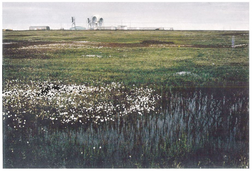
Figure 1. Point Barrow research site (Cover of Elias et al.,1996).
Citation
Walker, D.A. 2018. Arctic Vegetation Plots Legacy Project Barter Island and Point Barrow, Alaska, 1994. ORNL DAAC, Oak Ridge, Tennessee, USA. https://doi.org/10.3334/ORNLDAAC/1534
Table of Contents
- Data Set Overview
- Data Characteristics
- Application and Derivation
- Quality Assessment
- Data Acquisition, Materials, and Methods
- Data Access
- References
Data Set Overview
This dataset provides vegetation cover and environmental plot and soil data collected at two U.S. Air Force sites at Barter Island (BI) and Point Barrow (B), on the coastal North Slope of Alaska, in 1994. At Barter Island, 31 plots, and 30 plots at Barrow, were subjectively located in 14 plant communities. The investigation was part of a larger study initiated by the United States Congress to provide an opportunity to enhance the stewardship of the natural and cultural resources land under Department of Defense jurisdiction. These two sites were characterized to build an inventory of the biotic communities to compare them to historic communities.
During the vegetation survey, 61 releves (31 at Barter Island, and 30 at Barrow) were subjectively located in 14 plant communities and 4 broad habitat types including: 1) coastal salt marsh vegetation (4 plots), 2) dry coastal beach and sand dune vegetation (3 plots), 3) sedge grass and dwarf shrub mire and fen vegetation (36 plots), and 4) dry and mesic dwarf-shrub and graminoid vegetation on non-acidic substrate (18 plots). Species and environmental data including subjective site assessments were collected in the field. The size of each sample area was estimated after a complete species list was obtained and varied from 14 to 500 square meters. Soil samples were brought back to the lab for chemical analysis.
The plots were not permanently marked in 1994, but were identified on aerial photographs. From this information, plot GPS coordinates have been determined and are reported in this dataset.
The Pre-ABoVE vegetation plot datasets were curated to create the Alaska Arctic Vegetation Archive (AVA-AK; Walker et al. 2016b, Walker 2013). The AVA-AK is a regional database that is part of the larger Arctic Vegetation Archive (Walker 2016a, Walker et al. 2013, Walker and Raynolds 2011). The database contains vegetation plots from homogeneous plant communities with tables of cover or cover-abundance scores for all species and accompanying environmental site data. Field data were collected using Braun-Blanquet, US National Vegetation Classification protocols, or comparable methods.
Project: Arctic-Boreal Vulnerability Experiment (ABoVE)
The Arctic-Boreal Vulnerability Experiment (ABoVE) iis a NASA Terrestrial Ecology Program field campaign that will take place in Alaska and western Canada between 2016 and 2021. Climate change in the Arctic and Boreal region is unfolding faster than anywhere else on Earth. ABoVE seeks a better understanding of the vulnerability and resilience of ecosystems and society to this changing environment.
Acknowledgements:
These data files were edited by Donald A. Walker, Amy L. Breen and Lisa A. Druckenmiller at the University of Alaska Fairbanks' Alaska Geobotany Center and obtained via the Arctic Geoecological Atlas (http://arcticatlas.geobotany.org/), which provides access to existing Arctic vegetation plot and map data in support of the ABoVE campaign.
Data Characteristics
Spatial Coverage: Barter Island (BI) and Point Barrow (B), on the coastal North Slope of Alaska
ABoVE Site Designation:
Domain: Core ABoVE region
State/territory: Alaska (study sites around Barrow and Barter Island)
Grid cells: Ahh1Avv0Bh2Bv1, Ahh1Aw0Bh3Bv3
Spatial Resolution: Point resolution. Plots ranged in size from 14-500 square meters.
Temporal Coverage: August 1994, 19940801-19940811
Temporal Resolution: Each plot was sampled once
Study Area (All latitude and longitude given in decimal degrees)
|
Site |
Westernmost Longitude |
Easternmost Longitude |
Northernmost Latitude |
Southernmost Latitude |
|---|---|---|---|---|
|
Barrow |
-156.64432 |
-156.60601 |
71.33400 |
71.32265 |
|
Barter Island
|
-143.66956 |
-143.59660 |
70.13394 |
70.12040 |
Table 1. Data and companion files and descriptions.
| Data File Name | Description |
|---|---|
| Barter_Barrow_Species_Data.csv |
This file contains species cover data for the vegetation plots. Species cover classes are old Braun-Blanquet: r (rare), + (common, but less than 1 percent cover), 1 (1-5 percent), 2 (6 to 25 percent), 3 (26 to 50 percent), 4 (51 to 75 percent), 5 (76 to 100 percent). The field plot numbers in the modified source data are the authors. The author’s plot numbers, location initials BI (Barter Island) and B (Barrow), releve number, and occasionally a letter, A or B that represent a releve microsite. |
| Barter_Barrow_Environmental_Data.csv |
Plot data including soil code, moisture, slope, aspect, and topography data. Also includes percent groundcover. |
| Barter_Barrow_Soil_Data.csv | These are the soils data Barrow and Barter Island. Soils data include soil moisture, bulk density, pH, and thaw depth. |
| Barter_Barrow_Soil_Descriptions.csv | Soil descriptions transcribed directly from field forms including horizon, horizon depth, and other field descriptions. |
|
Companion Files |
|
| Barter_Barrow_Env_Codes_Scalars.pdf | Codes and scalars used in the Barter_Barrow_Environmental_Data.csv are defined and described in this companion file. |
| Barter_Barrow_Veg_Plots_Photos.pdf |
These are photographs of the vegetation plots. Not all plots have photographs, and due to light leaks, many of the existing photographs were cropped for presentation. |
Data File Information:
There are four data files with this dataset in comma-separated (.csv) format. These data may also be found in the TURBOVEG database.
Missing data are represented as -9999.
Barter_Barrow_Species_Data.csv
The source of these data is the data report Elias et al. (1996: Appendix E).
Both the author's determination and the current taxonomy according to the Panarctic Species List (PASL) are listed. Taxa are listed in alphabetical order according to the accepted PASL name.
Species cover classes are old Braun-Blanquet: r (rare), + (common, but less than 1 percent cover), 1 (1-5 percent), 2 (6 to 25 percent), 3 (26 to 50 percent), 4 (51 to 75 percent), 5 (76 to 100 percent). In four instances, taxa were lumped into a single taxon in the PASL: 1) Dicranum scoparium (Dicranum scoparium and Dicranum majus), 2) Dicranum spadiceum (Dicranum spadiceum and Dicranum angustum), 3) Salix rotundifolia (Salix rotundifolia ssp. reticulata and Salix rotundifolia x pulchra), 4) Tortula leucostoma (Tortula leucostoma and Desmatodon leucostoma). The field plot numbers in the modified source data are the authors. The author’s plot numbers, location initials BI (Barter Island) and B (Barrow), releve number, and occasionally a letter, A or B that represent a releve microsite.
This file contains species cover data for the vegetation plots. Taxa are listed in alphabetical order according to the accepted PASL name. The plot numbers are prefixed with either Barter Island (BI) or Barrow (B).
|
Column Numbers |
Column Name |
Description |
|---|---|---|
|
1 |
PASL_TAXON_SCIENTIFIC_NAME_NO_AUTHORS |
Current Taxonomy according to the Panarctic Species List (PASL) without authors names |
|
2 |
PASL_TAXON_SCIENTIFIC_NAME_WITH_AUTHOR(S) |
Current Taxonomy according to the Panarctic Species List (PASL) |
|
3 |
DATASET_TAXON |
Dataset taxonomy |
|
4 to 65 |
BI-1 BI-28, B-1 TO B-31 |
Column headings are all 61 plot numbers. Species cover data are given as percentage. |
Barter_Barrow_Environmental_Data.csv
The source of these data is the Legacy data report by Elias et al. (1996: Figure 2, Table 5, Appendix E), original datasheets, and L. Druckenmiller used the aerial photographs in the report and Google Earth to estimate the plot latitudes and longitudes, in that order.
Codes and scalars are defined and described in the companion file: Barter_Barrow_Env_Codes_Scalars.pdf
| Column Name | Units | Description |
|
ORDER |
|
Sort order |
|
FIELD_RELEVE_NUMBER |
|
Plot number |
|
TURBOVEG_ACCESSION_NUMBER |
|
Turboveg database are accession numbers |
|
PLANT_COMMUNITY_NAME |
|
|
|
DATE |
YYYYMMDD |
Survey date |
|
LATITUDE |
Decimal degrees, WGS 84 |
Latitude estimated from aerial photographs in the report in conjunction with Google Earth |
|
LONGITUDE |
Decimal degrees, WGS 84 |
Longitude estimated from aerial photographs in the report in conjunction with Google Earth |
|
RELEVE_MEASUREMENT |
M X M |
Plot size |
|
PLOT_LOCATION_ DESCRIPTION |
|
|
|
PLANT_COMMUNITY_DESCRIPTION |
|
|
|
SLOPE |
Degrees |
Slope of plot area in degrees |
|
ASPECT |
Degrees |
Aspect of plot area in degrees |
|
LANDFORMS |
Code |
Refer to the code defined in companion file Barter_Barrow_Env_Codes_Scalars.pdf |
|
SURFICIAL_ GEOLOGY |
Code |
Refer to the code defined in companion file Barter_Barrow_Env_Codes_Scalars.pdf |
|
SURFICIAL_GEOMORPHOLOGY |
Code |
Refer to the code defined in companion file Barter_Barrow_Env_Codes_Scalars.pdf |
|
MICROSITE |
Code |
Refer to the code defined in companion file Barter_Barrow_Env_Codes_Scalars.pdf |
|
SITE_MOISTURE |
Scalar |
Refer to the scalar defined in companion file Barter_Barrow_Env_Codes_Scalars.pdf |
|
SOIL_MOISTURE |
Scalar |
Refer to the scalar defined in companion file Barter_Barrow_Env_Codes_Scalars.pdf |
|
TOPOGRAPHIC_POSITION |
Code |
Refer to the code defined in companion file Barter_Barrow_Env_Codes_Scalars.pdf |
|
SOIL_UNIT |
Code or Comment |
Refer to the code defined in companion file Barter_Barrow_Env_Codes_Scalars.pdf |
|
EXPOSURE_SCALE |
Scalar |
Refer to the scalar defined in companion file Barter_Barrow_Env_Codes_Scalars.pdf |
|
ESTIMATED_SNOW_DURATION |
Scalar |
Refer to the scalar defined in companion file Barter_Barrow_Env_Codes_Scalars.pdf |
|
ANIMAL_DISTURBANCE |
Scalar (remarks) |
Refer to the scalar defined in companion file Barter_Barrow_Env_Codes_Scalars.pdf |
|
STABILITY |
Scalar (remarks) |
Refer to the scalar defined in companion file Barter_Barrow_Env_Codes_Scalars.pdf |
|
LOW_SHRUBS |
% |
Percent of plot cover that is low shrubs |
|
DWARF_SHRUBS |
% |
Percent of plot cover that is dwarf shrubs |
|
EVERGREEN_SHRUBS |
% |
Percent of plot cover that is evergreen shrubs |
|
DECIDUOUS_SHRUBS |
% |
Percent of plot cover that is deciduous shrubs |
|
COVER_FORBS |
% |
Percent of plot cover that is forbs |
|
COVER_GRAMINOIDS |
% |
Percent of plot cover that is graminoids |
|
COVER_LICHEN LAYER |
% |
Percent of plot cover that is lichen |
|
COVER_BRYOPHYTES |
% |
Percent of plot cover that is bryophytes |
|
COVER_BARE_ROCK |
% |
Percent of plot cover that is bare rock |
|
COVER_BARE_SOIL |
% |
Percent of plot cover that is bare soil |
|
COVER_OPEN_WATER |
% |
Percent of plot cover that is water |
|
COVER_FROST_SCAR |
% |
Percent of plot cover that is frost scar |
|
COVER_TOTAL_DEAD |
% |
Percent of plot cover that is dead vegetation |
|
MEAN_CANOPY_HEIGHT |
CM |
Mean vegetation height in centimeters |
Barter_Barrow_Soil_Data.csv
These are the soils data Barrow and Barter Island. Soils data include soil moisture, bulk density, pH, and thaw depth from Elias et al. (1996, Appendix E).
A sample of soil at or near 10 cm depth was collected and gravimetric soil moisture, bulk density, and soil pH (saturated paste method) were determined in a lab. Thaw depth was measured in the field.
All soil samples were collected at 10-cm depth. Data not provided are represented as -9999.
| Column Name | Units | Description |
|
ORDER |
|
|
|
FIELD NUMBER |
|
|
|
DATE |
YYYYMMDD |
|
|
LATITUDE |
Decimal degrees, WGS 84 |
Latitude estimated from aerial photographs in the report in conjunction with Google Earth |
|
LONGITUDE |
Decimal degrees, WGS 84 |
Longitude estimated from aerial photographs in the report in conjunction with Google Earth |
|
SOIL_MOISTURE |
% |
Soil moisture |
|
BULK_DENSITY |
G/CUBIC CM |
Bulk density |
|
SOIL_PH |
|
Soil pH (paste) |
|
THAW_DEPTH |
CM |
Thaw depth, mean of 5 measurements |
Barter_Barrow_Soil_Descriptions.csv
Soil descriptions transcribed directly from field forms entered by L. Druckenmiller.
| Column Name | Units | Description |
|---|---|---|
|
PLOT |
|
Plot number |
|
DATE |
YYYYMMDD
|
Survey date |
|
DEPTH |
CM |
Depth range of described soil horizon |
|
HORIZON |
|
Soil horizon |
|
DESCRIPTION_NOTES |
|
Data from field forms entered by L. Druckenmiller including brief soil descriptions. |
Application and Derivation
Two sites were characterized to build an inventory of the present biotic communities to compare them to historic communities.
Quality Assessment
During compilation of these data from Elias et al., (1986) in support of the ABoVE campaign, the Alaska Arctic Geoecological Atlas used aerial photographs and Google Earth to estimate plot latitudes and longitudes and corrected plant community names for plots BI-2,5, BI-27, B-17, and B-18 (by D. A. Walker in 2015).
Data Acquisition, Materials, and Methods
Site Description
The data were collected as part of the Legacy Resource Management Program (Department of Defense, Legacy Project Number 0742) that was part of a larger study initiated in 1991 by the United States Congress to provide an opportunity to enhance the stewardship of the natural and cultural resources on the more than 25 million acres of land under Department of Defense jurisdiction. To achieve this goal, the Department of Defense initially gave high priority to inventorying, protecting, and restoring natural resources. In Alaska, two U.S. Air Force sites on the coastal North Slope of Alaska, Barter Island and Barrow, were characterized to build an inventory of the present biotic communities to compare them to historic communities. Dr. Donald A. (Skip) Walker conducted the vegetation inventory in 1994, the results of which are included in a data report by Elias et al. (1996).
Vegetation Survey
During the vegetation survey, 61 releves (31 at Barter Island and 30 at Barrow) were subjectively located in 14 plant communities and 4 broad habitat types including: 1) coastal salt marsh vegetation (4 plots), 2) dry coastal beach and sand dune vegetation (3 plots), 3) sedge grass and dwarf shrub mire and fen vegetation (36 plots), and 4) dry and mesic dwarf-shrub and graminoid vegetation on non-acidic substrate (18 plots). Species and environmental data including subjective site assessments were collected in the field.
The size of each sample area was estimated after a complete species list was obtained and varied from 14 to 500 square meters.
Species cover classes are old Braun-Blanquet: r (rare), + (common, but less than 1 percent cover), 1 (1-5 percent), 2 (6 to 25 percent), 3 (26 to 50 percent), 4 (51 to 75 percent), 5 (76 to 100 percent).
In four instances, taxa were lumped into a single taxon in the PASL: 1) Dicranum scoparium (Dicranum scoparium and Dicranum majus), 2) Dicranum spadiceum (Dicranum spadiceum and Dicranum angustum), 3) Salix rotundifolia (Salix rotundifolia ssp. reticulata and Salix rotundifolia x pulchra), 4) Tortula leucostoma (Tortula leucostoma and Desmatodon leucostoma).
The plots were not permanently marked but were located on aerial photographs. Lisa Druckenmiller used the aerial photographs in the report and Google Earth to estimate the plot latitudes and longitudes, in that order.
Soil Samples
A sample of soil at or near 10 cm depth was collected and gravimetric soil moisture, bulk density, and soil pH (saturated paste method) were determined in a lab. Thaw depth was measured in the field.
Soil descriptions were transcribed directly from field forms and entered by L. Druckenmiller.
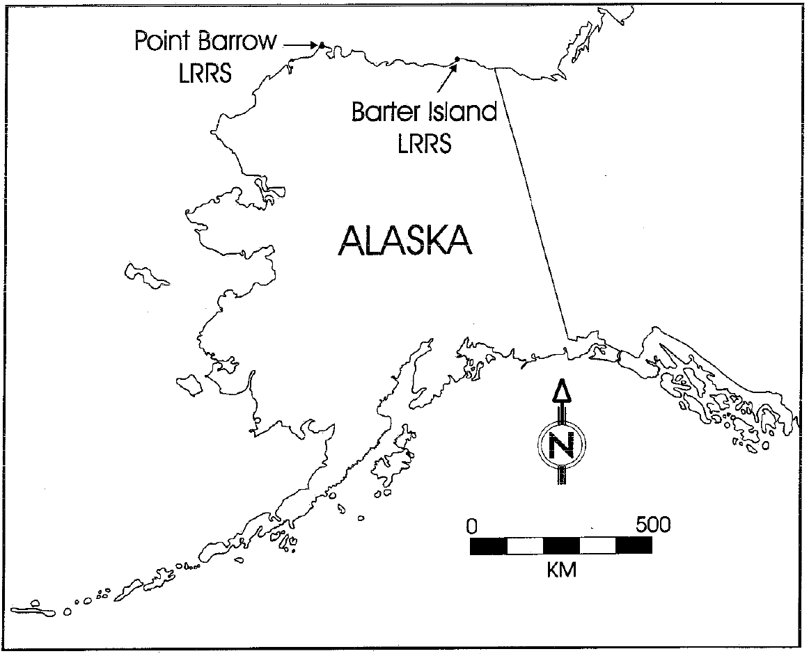
Figure 2. Location of Barrow and Barter Island research sites.
The report Elias et al. (1996) also includes data on Holocene and modern insects, and Holocene plant communities (pollen).
This dataset was provided by the GINA repository at: http://agc.portal.gina.alaska.edu/catalogs/10672-alaska-arctic-vegetation-archive-legacy-vegeta
Data Access
These data are available through the Oak Ridge National Laboratory (ORNL) Distributed Active Archive Center (DAAC).
Arctic Vegetation Plots Legacy Project Barter Island and Point Barrow, Alaska, 1994
Contact for Data Center Access Information:
- E-mail: uso@daac.ornl.gov
- Telephone: +1 (865) 241-3952
References
Elias, S., S. K. Short, D. A. Walker, and N. A. Auerbach. 1996. Historical biodiversity at Remote Air Force Sites in Alaska. Legacy Resource Management Program Project #0742, Point Barrow and Barter Island Long Range Radar Sites, Alaska. Data Report, Institute of Arctic and Alpine Research, University of Colorado, Boulder, Colorado, USA.