Documentation Revision Date: 2024-05-02
Dataset Version: 2.1
Summary
The soil respiration FD chambers are fully automated, low-powered systems that measure soil surface CO2 efflux and ambient atmospheric CO2 concentrations using an eosGP CO2 gas analyzer and pumping system. Flux was calculated using the two CO2 values and a chamber-specific precalibrated constant. Two or three FD chambers were deployed at each site.
This dataset includes 11 data files in comma separated values (*.csv) format.

Figure 1. a) A Soil Respiration Station (SRS) deployed at a boreal forest site in central Alaska; b) the SRS data logger; c) a Forced Diffusion Chamber (FD chamber) installed at a site.
Citation
Minions, C., S. Natali, J.D. Watts, S. Ludwig, and D. Risk. 2019. ABoVE: Year-Round Soil CO2 Efflux in Alaskan Ecosystems, Version 2.1. ORNL DAAC, Oak Ridge, Tennessee, USA. https://doi.org/10.3334/ORNLDAAC/1762
Table of Contents
- Dataset Overview
- Data Characteristics
- Application and Derivation
- Quality Assessment
- Data Acquisition, Materials, and Methods
- Data Access
- References
- Dataset Revisions
Dataset Overview
This dataset provides soil-surface CO2 efflux derived from measurements of soil respiration with FD chambers. SRS were installed at 11 boreal and tundra sites along a broad south-to-north transect starting from near Fairbanks in interior Alaska and extending to Atqasuk in northern Alaska. Each SRS measures soil respiration and ambient atmospheric CO2 concentrations with a forced diffusion (FD) chamber to derive soil CO2 flux. The SRS also measures soil CO2 concentrations and temperatures using instrumented chambers buried at 5, 10, and 15 cm depths in the soil profile. At the highest measurement frequency, data is collected hourly, and during the lowest winter frequency, every 48 hours. The data include flux values and running median filtered values from the two or three FD chambers at each site. Soil CO2 and temperature profile data (beginning June 2017) were collected beginning 2016-08-18 through 2023-09-02 (dates vary per site). As of this publication, sampling is continuing, and new data will be added as available.
The soil respiration FD chambers are fully automated, low-power systems that measured soil surface CO2 efflux and ambient atmospheric CO2 concentrations using an eosGP CO2 gas analyzer and pumping system. Flux was calculated using the two CO2 values and a chamber-specific precalibrated constant. Two or three FD chambers were deployed at each site.
Project: Arctic-Boreal Vulnerability Experiment
The Arctic-Boreal Vulnerability Experiment (ABoVE) is a NASA Terrestrial Ecology Program field campaign being conducted in Alaska and western Canada, for 8 to 10 years, starting in 2015. Research for ABoVE links field-based, process-level studies with geospatial data products derived from airborne and satellite sensors, providing a foundation for improving the analysis, and modeling capabilities needed to understand and predict ecosystem responses to, and societal implications of, climate change in the Arctic and Boreal regions.
Related Datasets
Minions, C., S. Natali, S. Ludwig, and J. Watts. 2018. ABoVE: Year-round Soil CO2 Efflux in Alaskan Ecosystems. ORNL DAAC, Oak Ridge, Tennessee, USA. https://doi.org/10.3334/ORNLDAAC/1620
- User Note: Minions et al. (2018) is Version 1 of the Year-round Soil CO2 Efflux data. The data from these previously reported sites and time periods have undergone more rigorous processing and are provided in this Version 2.1 dataset (Minions et al., 2019). Version 2.1 replaces Version 1 data and includes additional sites and extended temporal coverage.
Acknowledgments
This work was funded by the NASA ABoVE project (grant NNX15AT81A).
Data Characteristics
Spatial Coverage: Alaska, USA
ABoVE Reference Locations
Domain: Core ABoVE
State/Territory: Alaska
Grid Cells: Ah01av0 Bh7bv5 Ch042cv32, Ah01av0 Bh6bv4 Ch40cv29, Ah01av0 Bh6bv5 Ch37cv34, Ah01av0 Bh8bv3 Ch48cv21,
Ah01av0 Bh6bv5 Ch39cv32
Spatial Resolution: Multiple points
Temporal Coverage: 2016-08-18 to 2023-09-02
Temporal Resolution: Hourly
Study Area: (all latitudes and longitudes given in decimal degrees)
| Site | Westernmost Longitude | Easternmost Longitude | Northernmost Latitude | Southernmost Latitude |
|---|---|---|---|---|
| full extent | -157.410 | -146.558 | 70.47 | 63.880 |
Data File Information
There are 11 data files in comma separated values (*.csv) format.
The naming convention of the files is Alaska_X_CO2_flux.csv, where X designates the site code as shown in Table 3 of Section 5.
Table 1. File names and descriptions.
| File Name | Description |
|---|---|
| Alaska_AKB_CO2_flux.csv | CO2 flux, soil CO2, and temperature data, Anaktuvuk burned site |
| Alaska_AKU_CO2_flux.csv | CO2 flux, soil CO2, and temperature data, Anaktuvuk unburned site |
| Alaska_ATQ_CO2_flux.csv | CO2 flux, soil CO2, and temperature data, Atqasuk site |
| Alaska_BNZ_CO2_flux.csv | CO2 flux, soil CO2, and temperature data, Bonanza Creek site |
| Alaska_EML_CO2_flux.csv | CO2 flux, soil CO2, and temperature data, Eight Mile Lake site |
| Alaska_HCB_CO2_flux.csv | CO2 flux, soil CO2, and temperature data, Hess Creek burned site |
| Alaska_HCU_CO2_flux.csv | CO2 flux, soil CO2, and temperature data, Hess Creek unburned site |
| Alaska_IMH_CO2_flux.csv | CO2 flux at the I-MINUS high site |
| Alaska_IML_CO2_flux.csv | CO2 flux at the I-MINUS low site |
| Alaska_NCB_NEW_CO2_flux.csv | CO2 flux, soil CO2, and temperature data, Nome Creek burned site |
| Alaska_NCU_OLD_CO2_flux.csv | CO2 flux at the Nome Creek unburned site |
Data File Details
- Missing values are represented by -9999.
- Note that soil CO2 and temperature profile data were measured only after June 2017. In files with no data after June 2017 (e.g., Alaska_NCU_OLD_CO2_flux.csv) the variable columns are provided for consistency, but all values are missing (-9999). For data files beginning in August 2016 and continuing (e.g., Alaska_BNZ_CO2_flux.csv) to the present, these variables are missing until June 2017.
- Due to some technical issues, some sites are missing data for some of the listed variables.
- See Table 4 for the data availability at each site and known data gaps.
Table 2. Variable names and descriptions in the processed SRS data files.
| Variable | Units | Description |
|---|---|---|
| date | YYYY-MM-DD | Date of measurement |
| date_time | hh:mm:ss | Time of measurement |
| FD#_flux | μmol CO2 m-2 s-1 | Soil CO2 flux values calculated for FD chambers."#" indicates the chamber number; there are two or three chambers per site (e.g., FD28, FD17, FD29) |
| FD#_flux_median | μmol CO2 m-2 s-1 | Soil CO2 flux value after running median filter. There are two or three chambers per site (e.g., FD28, FD17, FD29) |
| soil_CO2_5cm | ppm | Soil CO2 concentration at 5 cm depth |
| soil_CO2_15cm | ppm | Soil CO2 concentration at 15 cm depth |
| soil_CO2_25cm | ppm | Soil CO2 concentration at 25 cm depth |
| soil_temp_5cm | degrees C | Soil temperature at 5 cm depth |
| soil_temp_15cm | degrees C | Soil temperature at 15 cm depth |
| soil_temp_25cm | degrees C | Soil temperature at 25 cm depth |
| ATM_TEMP | degrees C | Approximate atmospheric temperature (between 5-30 cm above soil surface depending on site) |
Application and Derivation
Measurements of soil CO2 efflux provide critical information on soil carbon balance. The soil respiration station FD chamber provides a stable field technique for measuring soil CO2 efflux in remote areas such as Alaska. The method currently uses 10 times less power than a comparable autochamber, with the potential for further gains. It is also inherently reliable because there are no moving parts.
Quality Assessment
All raw CO2 concentration measurements that were below the instrument's limit of detection (LOD) were discarded before fluxes were calculated. A LOD for CO2 measured from the FD chambers was also determined and applied.
Data Acquisition, Materials, and Methods
Study Area
Eleven boreal and tundra sites were selected for year-round soil flux measurements along a broad south-to-north transect from near Fairbanks in interior Alaska to Atqasuk in northern Alaska.
Table 3. Site details.
| Site | Code | Latitude | Longitude | Description |
|---|---|---|---|---|
| Anaktuvuk burned site | AKB | 68.990797 | -150.2702 | Located near the Anaktuvuk river north of Toolik field station within the severely burned area of the 2007 Anaktuvuk river fire. The vegetation is characterized by moss and tussock tundra. The SRS was deployed in late June of 2017. |
| Anaktuvuk unburned site | AKU | 68.929906 | -150.2798 | Located in an undisturbed area near the Anaktuvuk river north of Toolik field station. The vegetation at the site is characterized by moss and tussock tundra. The SRS was deployed in late June of 2017. |
| Atqasuk site | ATQ | 70.47 | -157.41 | Located near the city of Atqasuk, and the vegetation at the site is characterized by sedge and tussock tundra. The SRS was deployed in late July of 2017. |
| Bonanza Creek site | BNZ | 64.695999 | -148.325677 | Located near the Bonanza Creek LTER Site, within a boreal black spruce stand. The SRS was deployed in August of 2016. |
| Eight Mile Lake site | EML | 63.880123 | -149.256008 | Located off of the Stampede Trail in Healy. The area is characterized by moist tundra and sedge/shrub vegetation. The SRS was deployed in August of 2016. |
| Hess Creek burned site | HCB | 65.568762 | -148.92344 | Located off of the Dalton Highway between mile 11 and 12, within a burned boreal black spruce forest (1995). The SRS was deployed in August of 2016. |
| Hess Creek unburned site | HCU | 65.567389 | -148.925157 | Located off of the Dalton Highway between mile 11 and 12, within an unburned boreal black spruce forest. The SRS was deployed in August of 2016. |
| I-MINUS high site | IMH | 68.557159 | -149.532908 | Located approximately 1 km off of the Dalton Highway, a few miles south of Toolik Field Station. The station is located on top of a hillside and is characterized by tussock tundra. The SRS was deployed in August of 2016 and removed in late June of 2017. |
| I-MINUS low site | IML | 68.5593 | -149.51605 | Located approximately 1 km off of the Dalton Highway, a few miles south of Toolik Field Station. The station is in a lowland, wet sedge fen area (Riparian). The SRS was deployed in August of 2016 and removed in late June of 2017. |
| Nome Creek burned site | NCB_NEW | 65.28603 | -146.55833 | Located less than a 1 km off of the Steese Highway near mile 63. The station is in a burned area (2004), and the vegetation is characterized by willow/herbaceous scrub. The SRS was deployed in early September of 2017. |
| Nome Creek unburned site | NCU_OLD | 65.285561 | -146.560019 | Located within the White Mountain Recreation Area, on a south-facing slope characterized by willow/herbaceous scrub vegetation. The SRS was deployed in August of 2016 and removed in late June of 2017. |
Flux Measurements and Calculations-revised according to the new doc from PI
The soil respiration station (SRS) is a fully automated, low-powered system that measures soil surface CO2 flux from three FD chambers (Figure 1). The FD chambers function in a similar capacity to dynamic chambers, but instead of employing moving parts, the FD chambers use passive membranes to regulate the flow of gas allowing for instrumentation to be powered off between measurement intervals, thereby achieving very low power consumption and high reliability (Risk et al., 2011). Two measurements are recorded from each FD chamber: one for atmospheric (Atm) CO2 and one for soil CO2 using an eosGP CO2 gas analyzer (Eosense Inc.), and pump system. The units for soil CO2 and atm CO2 concentrations are in ppm. Using these two values, and a chamber-specific, pre-calibrated flux constant, G, can be determined (Equation 1).
Flux = G (SoilCO2 - AtmCO2) (1)
The units for flux are in μmol CO2 m-2 s-1. At the highest measurement frequency, data are collected hourly, and at the lowest frequency once per day. The measurement frequency is reduced during the winter months to conserve power. The SRS also records the concentration of CO2 throughout the soil profile at depths of 5, 15 and 25 cm using soil-depth chambers (Figure 2). Each of the chambers is equipped with a thermocouple wire. Measurements for profile CO2 are taken at the same frequency as the flux data.
Soil CO2 and Temperature Measurements
The SRS also records the concentration of CO2 throughout the soil profile at depths of 5, 15 and 25 cm using soil-depth chambers. Each of the chambers is equipped with a thermocouple wire. Measurements for profile CO2 are taken at the same frequency as the flux data.
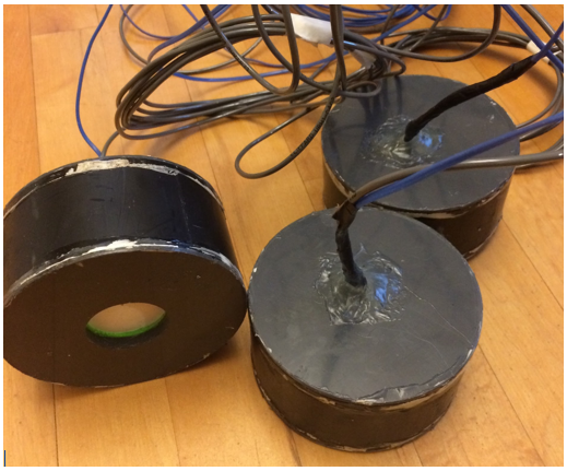
Figure 2. Soil-Depth chambers used to measure the concentration of CO2 and temperature within the soil profile at depths of 5, 15 and 25 cm.
SRS Data Processing
Data from the soil respiration stations are recorded on a set measurement frequency using either a CR800 series or CR1000 series datalogger (Campbell Scientific, Logan, Utah, USA). The data were initially processed by applying a function that “cleans up” the raw data file.
The first step in this clean-up process removes any data recorded at an insufficient battery voltage level (voltage < 12 volts). At voltage levels below this defined threshold, the system does not have sufficient power to function properly.
Any soil or atmospheric CO2 concentration measurements from the FD chambers that were below 200 ppm were filtered out. To remove any unnatural spikes and noise within the dataset, a moving average based on a set window size was used to compare a measurement to those before and after. If the data point in question was greater than the moving average by 200 ppm or more, the measurement was replaced with -9999.
Once the CO2 concentration data were ‘cleaned-up’, the flux for each FD chamber was calculated. The flux data were then filtered again, using a moving average based on a set window size, similar to what was done for the CO2 concentration data. If the average of the window plus two standard deviations were less than the flux value in question, the data point was replaced with -9999. Figures of the data were generated for before and after the initial processing for comparison to make sure no viable data were removed.
The second part of the data processing involves assessing, and removing any spikes that may remain, and any periods where there may have been an equipment malfunction that was not caught during the first round of processing. Lastly, a running median was calculated for the flux data using the previous five measurements to reduce noise within the dataset.
Table 4. Data availability at each Site.
- Sites marked with * are no longer collecting data.
- Some stations were deployed in 2016, and others in 2017. Some stations were removed in 2017. Compare to Table 3.
- There may be a few sporadic measurements within the defined gap period.
| Site | Data Start Date (yyyy-mm-dd) | Data End (yyyy-mm-dd) | Large Data Gaps (yyyy-mm-dd) |
|---|---|---|---|
| Anaktuvuk Burned | 2017-06-23 | 2019-08-31 | 2017-10-05 to 2018-02-20, 2018-03-18 to 2018-07-11, 2019-01-07 to 2019-02-20 |
| Anaktuvuk Unburned | 2017-06-23 | 2018-09-02 | 2017-11-26 to 2018-02-10, 2018-02-21 to 2018-03-23, 2018-04-20 to 2018-07-11 |
| Atqasuk* | 2017-07-28 | 2018-07-30 | 2017-12-26 to 2018-02-04, 2018-02-18 to 2018-05-12, 2018-06-02 to 2018-06-27 |
| Bonanza Creek | 2016-08-29 | 2023-06-03 | 2016-09-12 to 2016-10-02, 2016-10-28 to 2017-02-14, 2017-02-25 to 2017-03-11, 2018-01-20 to 2018-03-09, 2018-04-08 to 2020-04-12, 2021-01-24 to 2021-03-04, 2022-01-23 to 2022-04-19 |
| Eight Mile Lake | 2016-08-18 | 2023-05-23 | 2016-11-25 to 2017-01-06, 2017-12-31 to 2018-07-04, 2019-01-13 to 2019-06-01, 2020-03-08 to 2020-06-03, 2021-01-12 to 2021-05-31, 2021-09-19 to 2022-07-28 |
| Hess Creek Burned | 2016-08-30 | 2023-02-22 | 2016-11-04 to 2017-03-03, 2018-01-12 to 2018-03-17, 2019-02-08 to 2019-03-14, 2019-05-10 to 2022-06-16, 2022-07-25 to 2022-10-13 |
| Hess Creek Unburned | 2016-08-28 | 2023-09-02 | 2016-10-17 to 2017-02-26, 2017-12-23 to 2018-03-21, 2018-12-30 to 2019-03-16, 2020-02-03 to 2020-03-27, 2021-01-28 to 2021-03-29, 2021-09-02 to 2021-11-22, 2022-01-09 to 2022-03-28 |
| I-MINUS High* | 2016-08-21 | 2016-11-16 | NA |
| I-MINUS Low* | 2016-08-19 | 2017-06-12 | 2016-11-14 to 2017-01-31, 2017-03-09 to 2017-04-09 |
| Nome Creek Burned NEW* | 2017-11-01 | 2018-08-25 | 2018-01-04 to 2018-02-05, 2018-02-13 to 2018-03-07, 2018-07-05 to 2018-07-19 |
| Nome Creek Unburned OLD* | 2016-08-28 | 2017-06-13 | 2016-11-13 to 2017-02-04 |
Data Access
These data are available through the Oak Ridge National Laboratory (ORNL) Distributed Active Archive Center (DAAC).
ABoVE: Year-Round Soil CO2 Efflux in Alaskan Ecosystems, Version 2.1
Contact for Data Center Access Information:
- E-mail: uso@daac.ornl.gov
- Telephone: +1 (865) 241-3952
References
Minions, C., S. Natali, S. Ludwig, and J. Watts. 2018. ABoVE: Year-round Soil CO2 Efflux in Alaskan Ecosystems. ORNL DAAC, Oak Ridge, Tennessee, USA. https://doi.org/10.3334/ORNLDAAC/1620
Risk, D., Nickerson, N., Creelman, C., McArthur, G., Owens, J., 2011. Forced Diffusion soil flux: A new technique for continuous monitoring of soil gas efflux. Agricultural and Forest Meteorology 151:1622-1631. https://doi.org/10.1016/j.agrformet.2011.06.020
Dataset Revisions
| Release Date | Version | Revision Notes |
| 2024-05-02 | 2.1 |
This release added extended temporal data for four sites: BNZ: Bonanza Creek, EML: Eight Mile Lake, HCB: Hess Creek Burned, and HCU: Hess Creek Unburned. Previously existing data were not changed. Note: The ORNL DAAC revised its methods for versioning datasets to be more consistent with data versioning practices at the NASA Earth Science Data and Information System (ESDIS) and the general Earth Science data community. With the revised versioning strategy, the dataset version number (including both major and minor version numbers) remain unchanged when a release only appends new data and existing data are not changed. |
| 2023-10-31 | 2.1 | This release added extended temporal data for five sites: AKB: Anaktuvuk Burned, BNZ: Bonanza Creek, EML: Eight Mile Lake, HCB: Hess Creek Burned, and HCU: Hess Creek Unburned. Previously existing data were not changed. |
| 2020-02-15 | 2.0 | This replaced and superseded the Version 1.0 data and includes additional measurement sites. |
|
2018-12-31 |
1.0 | Initial release of Minions et al. (2018), Version 1.0 of the Year-round Soil CO2 Efflux data. |