Documentation Revision Date: 2023-03-26
Dataset Version: 1
Summary
There are seven data files provided in comma-separated value (*.csv) format with this dataset.

Figure 1. Site locations. (a) in Northern Slope Alaska. (b) Central region of Alaska.
Citation
Bakian-Dogaheh, K., R.H. Chen, Y. Yi, T.D. Sullivan, R.J. Michaelides, A.D. Parsekian, K. Schaefer, A. Tabatabaeenejad, J. Kimball, and M. Moghaddam. 2023. Soil Matric Potential, Dielectric, and Physical Properties, Arctic Alaska, 2018. ORNL DAAC, Oak Ridge, Tennessee, USA. https://doi.org/10.3334/ORNLDAAC/2149
Table of Contents
- Dataset Overview
- Data Characteristics
- Application and Derivation
- Quality Assessment
- Data Acquisition, Materials, and Methods
- Data Access
- References
Dataset Overview
This dataset provides lab-measured soil properties, including soil water matric potential, soil dielectric properties, soil electrical conductivity, corresponding soil moisture. The dataset also includes the basic soil physical properties. Permittivity and soil electrical conductivity measurements were conducted using METER TEROS 12 probes. Soil moisture measurements were made with a TEROS 21 probe. The measurements were conducted in the lab over the span of three years. The purpose of soil collection and lab measurements was to develop an integrated framework that relates the hydrological properties to dielectric properties of permafrost active layer soil in support of the NASA Arctic and Boreal Vulnerability Experiment (ABoVE) Airborne Campaign.
Samples were collected from the surface to permafrost table in soil pits at nine sites along the Dalton Highway in northern Alaska and central regions of Alaska. For the northern slope sites, and from north to south, the sites include Franklin Bluffs, Sagwon, Happy Valley, Ice Cut, and Imnavait Creek. For the central region of Alaska sites, and from west to east, the sites include 8-Mile Lake, Creamers Field, Ballaine Road, and Scottie Creek. Sample collections were made from August 21 to August 27, 2018. Measurements in the lab were made over the span of three years.
Project: Arctic-Boreal Vulnerability Experiment
The Arctic-Boreal Vulnerability Experiment (ABoVE) is a NASA Terrestrial Ecology Program field campaign being conducted in Alaska and western Canada, for 8 to 10 years, starting in 2015. Research for ABoVE links field-based, process-level studies with geospatial data products derived from airborne and satellite sensors, providing a foundation for improving the analysis, and modeling capabilities needed to understand and predict ecosystem responses to, and societal implications of, climate change in the Arctic and Boreal regions.
Bakian-Dogaheh, K., R.H. Chen, M. Moghaddam, Y. Yi, and A. Tabatabaeenejad. 2020. ABoVE: Active Layer Soil Characterization of Permafrost Sites, Northern Alaska, 2018. ORNL DAAC, Oak Ridge, Tennessee, USA. https://doi.org/10.3334/ORNLDAAC/1759
- This dataset contains in situ measurements of soils sampled at some of the same sites
Additional Hydrology and Permafrost ABoVE datasets archived at the ORNL DAAC provide similar observations at other sites.
Acknowledgments
Funding was provided by NASA's Terrestrial Ecology program (grant NNX17AC65A) and a NASA Earth and Space Science Fellowship (grant 80NSSC18K1410).
Data Characteristics
Spatial Coverage: Five sites in northern Alaska along the Dalton Highway: Franklin Bluffs, Sagwon, Happy Valley, Ice Cut, and Imnavait Creek. Four sites in central Alaska: 8-Mile Lake, Creamers Field, Ballaine Road, and Scottie Creek.
ABoVE Reference Locations
Domain: Core ABoVE
Grid cells: Ah001v000, Ah001v001, Bh006v005, Bh007v007, Bh008v003,
Ch036v033, Ch040v032, Ch043v045, Ch048v021, Ch050v020, Ch051v019, Ch052v018
Spatial Resolution: Point locations
Temporal Coverage (Sample collection): 2018-08-21 to 2018-08-27
Temporal Resolution: Samples were collected within six days; measurements were performed in laboratory over three years
Study Area: Latitude and longitude are given in decimal degrees for the bounding box of the nine study sites
| Site | Westernmost Longitude | Easternmost These are the coordinates of the Longitude | Northernmost Latitude | Southernmost Latitude |
|---|---|---|---|---|
| Nine sites in northern and central Alaska, US | -149.30635 | -141.142333 | 69.812372 | 62.697352 |
Data File Information
There are seven data files in comma-separated value (*.csv) format provided with this dataset. The files provide measurements made in the laboratory for 66 soil samples collected in 2018 from 13 soil pits in nine study sites.
For each sample, the measurements cover the entire range of dry to saturation. The number of measurements varied depending on the sample situation. Measurements not made on samples are indicated as -9999.
Table 1. File names, variables, and descriptions
| File Number | File Name | Variable | Units/format | Description |
|---|---|---|---|---|
| 1 | Electromagnetic_Dielectric.csv | permittivity 70 mhz | mhz | The measurement was conducted using METER TEROS 12 probes. The probes measure the Raw ADC count. The Equation 8 adapted from TEROS11-12 manual was used to translate and report the RAW ADC count to dielectric permittivity: ε = (2.887 × 10⁻⁹× RAW3−2.080 × 10⁻⁵× RAW2+5.276 × 10⁻²× RAW−43.39)2 where RAW = raw sensor output. |
| 2 | Electromagnetic_Electrical_Conductivity.csv | electrical conductivity | mS cm-1 | Electrical conductivity measured using the (TEROS 12) sensor and (ProCheck) data logger |
| 3 | Electromagnetic_Soil_Moisture.csv | soil moisture | cm3 cm-3 | Volumetric water content of the soil sample corresponding to the dielectric measurements |
| 4 | Electromagnetic_Raw_ADC.csv | raw ADC count | 1 | This file provides raw ADC measurements |
| 5 | Matric_Potential.csv | matric_potential | kPa | Soil water matric potential measured using TEROS 21 sensor |
| 6 | Hydrology_Soil_Moisture | soil moisture | cm3 cm-3 | Volumetric water content of the soil sample corresponding to the matric potential measurements |
| 7 | Soil_Physical_Properties.csv | multiple variables, refer to Table 4 | refer to Table 4 | This file provides soil physical properties data. Refer to Table 4 |
Column naming conventions and descriptions: In files 1-6 listed above, the column names (columns A-BN) are the site abbreviations (XXX), soil pit number (Y), and soil sample number in the profile (Z). See Table 2.
Table 2. Column naming conventions and descriptions: XXX-Y-Z
| XXX | Site abbreviations: FB = Franklin Bluffs SGW = Sagwon HV = Happy Valley ICC = Ice Cut IMN = Imnavait Creek CF = Creamers Field BR = Ballaine Road SC = Scottie Creek EML = Eight Mile Lake |
| Y | Soil pit number |
| Z | Soil sample number in the profile |
Table 3. Example data from the file Electromagnetic_Dielectric.csv.
Column A is FB-1-1=Franklin Bluff site, soil pit 1, sample 1; Column B is Franklin Bluff site, soil pit 1, sample 2; etc.
| A | B | C | D | E | F | G | H | I | J | |
| FB-1-1 | FB-1-2 | FB-1-3 | FB-1-4 | FB-1-5 | FB-1-6 | FB-1-7 | FB-1-8 | SGW-1-1 | SGW-1-2 | |
| 1 | 2.61417 | 2.583316 | 2.92448 | 2.820721 | 2.737932 | 2.955662 | 3.018092 | 3.164076 | 2.287249 | 2.460296 |
| 2 | 2.779301 | 2.61417 | 3.091033 | 2.966061 | 2.903706 | 3.216306 | 3.091033 | 3.582964 | 2.246771 | 2.511475 |
Table 4.Variables in the file Soil_Physical_Properties.csv
| Column Name | Units | Description |
|---|---|---|
| soil_pit_number | Soil pit number, where the soil sample was collected. Includes site abbreviation: FB = Franklin Bluffs, SGW = Sagwon, HV = Happy Valley, ICC = Ice Cut, IMN = Imnavait Creek, CF = Creamers Field, BR = Ballaine Road, SC = Scottie Creek, EML = Eight Mile Lake |
|
| pit_sample_id | Samples were collected through the profile at different layers. Sample ID denotes samples from surface to permafrost table. | |
| sample_date | YYYY-MM-DD | Date samples were collected |
| latitude | degrees north | Latitude in decimal degrees of the site |
| longitude | degrees east | Longitude in decimal degrees of the site |
| min_depth | cm | Minimum sampling depth |
| max_depth | cm | Maximum sampling depth |
| field_bulk_density | g cm-3 | Bulk density of the soil sample in the field |
| porosity | cm3 cm-3 | Porosity of the soil sample |
| root_biomass | g g-1 (%) | Gravimetric fraction (expressed as percentage) of the sample organic matter (live and dead fine roots) with dimension >2 mm over the entire dry sample |
| soil_organic_matter | g g-1 (%) | Gravimetric fraction (expressed as percentage) of the soil organic matter with dimension <2 mm over the fraction of dry sample with dimension <2 mm (knowingly as soil) |
| fiber_content | cm3 cm-3 | Volumetric fraction of sample fiber content: the squeezed sample volume after wet sieving over the squeezed volume of wet sample (drained). |
| gravel | g g-1 (%) | Gravimetric fraction (expressed as percentage) of mineral particles (gravels) with size >2 mm over the total dry sample weight |
| sand | g g-1 (%) | Gravimetric fraction of the sand over the fraction of dry sample with dimension <2 mm (knowingly as soil) |
| silt | g g-1 (%) | Silt fraction (expressed as percentage) |
| clay | g g-1 (%) | Clay fraction (expressed as percentage) |
| soil_type | Type of mineral soil according to soil classification |
Application and Derivation
Soil hydrologic properties, soil organic matter, root biomass, and other soil physical properties are primarily important for parameterization of the ecosystem models to study the dynamics of the permafrost active layer under the regional warming trends in the Arctic area. Soil dielectric properties, particularly the dielectric behavior of the highly organic arctic soil and corresponding basic soil physical properties of the soil are important for remote sensing models that map the carbon and subsurface water characteristics of active layer using radar backscattered data.
This dataset provides a unique, comprehensive, and simultaneous characterization of basic soil physical properties along with water matric potential and soil dielectric measurement that is needed for developing an organic soil dielectric model to be used in support of NASA Arctic and Boreal Vulnerability Experiment (ABoVE) Airborne Campaign (AAC). The site locations were carefully selected to capture different landscapes within five benchmarks AAC flight lines known as Deadhorse, Toolik, Snag Yukon, Denali NEON, and Bonanza Creek. The field sampling was concurrent with August 2018 ABoVE L-band flight, while the laboratory measurements were conducted over 3 years.
Quality Assessment
For the soil physical characterization and for many of the properties (e.g., fiber content) multiple measurements were conducted and the mean value of the measurement is reported. Also, the measured values were consistent with previous published data (Bakian-Dogaheh et al., 2020). Soil texture analysis and soil organic matter measurement followed standard methods for the characterization of soils (Ward Laboratories). Other soil physical properties have been measured according to well-established procedures with necessary modifications for some variables. The quality of data derived from these techniques is discussed in a previously published dataset (Bakian-Dogaheh et al., 2020) and journal article (Bakian-Dogaheh et al., 2022).
Instruments being used in the measurement were calibrated according to manufacturer recommendations. TEROS 12 was used for measuring the soil dielectric and electrical conductivity, and its precision is provided in the manual. TEROS 21 is a porous ceramic disk probe to measure the soil water matric potential and its measurement accuracy and is reported in the manual provided along with the dataset.
Data Acquisition, Materials, and Methods
Samples were collected from the permafrost active layer of northern and central Alaska in August 2018. Lab measurements and analyses of soil samples included characterizing soil water retention curve by measuring soil matric potential and soil moisture, and also the soil dielectric characterization by measuring the relative dielectric permittivity, electrical conductivity, and corresponding soil moisture. Further analyses included basic soil physical properties of soil including root biomass, soil organic matter, fiber content, and other physical soil characteristics. Selected sites in northern Alaska are along Dalton Highway, and from north to south, the sites include Franklin Bluffs, Sagwon, Happy Valley, Ice Cut, and Imnavait Creek. For the central region of Alaska sites, and from west to east, the sites include 8-Mile Lake, Creamers Field, Ballaine Road, and Scottie Creek. Figure 1 shows the site locations.
Table 5. Site sampling locations.
| Site Name | Number of Soil Pits | Date of Sampling |
Latitude | Longitude | Pit Sample ID |
Number of Samples per Pit |
|---|---|---|---|---|---|---|
| Franklin Bluffs (FB) |
1 | 2018-08-26 | 69.812372 | -148.766486 | 1 | 8 |
| Sagwon (SGW) |
2 | 2018-08-22 | 69.479578 | -148.564442 | 1 | 6 |
| 69.476578 | -148.564433 | 2 | 8 | |||
| Happy Valley (HV) |
2 | 2018-08-25 | 69.155356 | -148.838789 | 1 | 8 |
| 69.155358 | -148.841800 | 2 | 5 | |||
| Ice Cut (ICC) |
2 | 2018-08-23 | 69.041894 | -148.827031 | 1 | 6 |
| 69.042483 | -148.825383 | 2 | 4 | |||
| Imnavait Creek (IMN) |
1 | 2018-08-24 | 68.604972 | -149.306350 | 5 | 5 |
| 8-Mile Lake (EML) |
1 | 2018-08-27 | 63.877590 | -149.255750 | 4 | 4 |
| Creamers Field (CF) |
1 | 2018-08-23 | 64.869467 | -147.739040 | 4 | 4 |
| Ballaine Road (BR) |
1 | 2018-08-26 | 64.915000 | -147.838638 | 4 | 4 |
| Scottie Creek (SC) |
1 | 2018-08-21 | 62.697352 | -141.142333 | 4 | 4 |
Soil Sampling Protocol
Soil samples were collected back-to-back from the surface down to the permafrost tables using a knife and a 1.89-liter plastic container from each soil pit (Figure 2). Each sample length, top to bottom, was approximately 11.5 cm and filled the entire container. The samples were shipped to the University of Southern California for lab measurement.
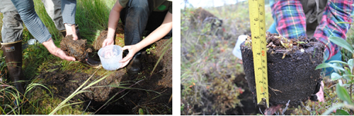
Figure 2. Samples harvested from the permafrost active layer.
Lab measurement protocol
Upon arrival to the lab, samples were divided into half, and TEROS 12 dielectric probes were inserted into the middle of the soil. (Figure 3). Measurements were started with saturated samples and made periodically while the samples dried. To expedite evaporation, the samples were under a constant air flow generated by a network of fans. The mean value of the Raw ADC from each dielectric probe was measured using ProCheck and translated into apparent dielectric constant. The gravimetric weight loss of the soil samples due to evaporation was recorded and translated into volumetric soil moisture based on sample volumes. The TEROS 12 also measures the soil electrical conductivity, which is reported in the dataset. Measurements were conducted two times from a saturation to dry point, and in each interval, and depending on the situation, between 9 to 34 data points were acquired.
The TEROS 21 porous disk probe was inserted after dielectric measurement, and the measurement was conducted two times from saturation to dry region. For each measurement, the sensor had good hydraulic contact with the soil to ensure accurate measurements. Similar to soil dielectric measurements, 20 measurements were conducted for each soil moisture point and the mean value is reported in this dataset.
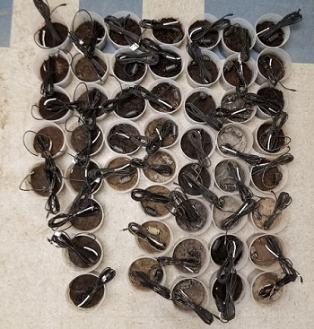

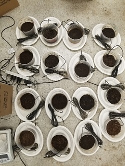
Figure 3. The laboratory set-up for 66 soil samples from 13 sampling locations at nine sites. Northern slope’s samples are in the top left figure. The top right figure shows the network of cooling fans to circulate the air and expedite evaporation. The lower figure is samples from central Alaska. The samples were divided into half and TEROS 12 and TEROS 21 were inserted to measure the soil dielectric and soil matric potential properties. Sample weight loss was tracked from saturation to dry conditions, and the gravimetric moisture content was translated to volumetric moisture content based sample volumes.
Data Access
These data are available through the Oak Ridge National Laboratory (ORNL) Distributed Active Archive Center (DAAC).
Soil Matric Potential, Dielectric, and Physical Properties, Arctic Alaska, 2018
Contact for Data Center Access Information:
- E-mail: uso@daac.ornl.gov
- Telephone: +1 (865) 241-3952
References
Bakian-Dogaheh, K., R.H. Chen, M. Moghaddam, Y. Yi, and A. Tabatabaeenejad. 2020. ABoVE: Active Layer Soil Characterization of Permafrost Sites, Northern Alaska, 2018. ORNL DAAC, Oak Ridge, Tennessee, USA. https://doi.org/10.3334/ORNLDAAC/1759
Bakian-Dogaheh, K., R.H. Chen, Y. Yi, J.S. Kimball, M. Moghaddam, and A. Tabatabaeenejad. 2022. A model to characterize soil moisture and organic matter profiles in the permafrost active layer in support of radar remote sensing in Alaskan Arctic tundra. Environmental Research Letters 17:025011. https://doi.org/10.1088/1748-9326/ac4e37