Documentation Revision Date: 2019-12-17
Dataset Version: 1
Summary
This dataset includes a shapefile (.shp compressed into .zip format) showing the time series of expansion of the thaw slump. Companion files include a Google Earth .kmz with the same information as the shapefile and an annotated .pdf file showing the change in eroded area and including recent aerial photographs of the slump area.
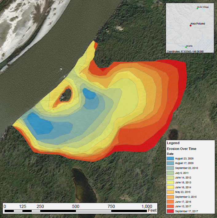
Figure 1. Annual expansion of a thaw slump on the East Fork Chandalar River near the community of Venetie, Alaska, from 2008 through 2017. The erosion time series was created by manually digitizing from ESRI basemap and Landsat 5, 7, and 8 imagery. The eroded area appears to be growing steadily, mostly to the east, with apparent limitation on growth to the north and south. Source: Thaw_Slump_Images.pdf companion file.
Citation
Anderson , V., D.R.N. Brown, and T.J. Brinkman. 2019. ABoVE: Annual Thaw Slump Expansion on East Fork Chandalar River, Alaska, 2008-2017. ORNL DAAC, Oak Ridge, Tennessee, USA. https://doi.org/10.3334/ORNLDAAC/1724
Table of Contents
- Dataset Overview
- Data Characteristics
- Application and Derivation
- Quality Assessment
- Data Acquisition, Materials, and Methods
- Data Access
- References
Dataset Overview
This dataset provides a time series of spatial data showing the expansion of a thaw slump on the East Fork Chandalar River near the community of Venetie, Alaska, from 2008 through 2017. The erosion of vegetated areas along the river was documented by manually digitizing imagery from ESRI basemaps and Landsat 5 (TM), 7 (ETM+), and 8 (OLI), using the band combination of shortwave infrared 2, shortwave infrared 1, and red.
Project: ABoVE
The Arctic-Boreal Vulnerability Experiment (ABoVE) is a NASA Terrestrial Ecology Program field campaign taking place in Alaska and western Canada between 2016 and 2021. Climate change in the Arctic and Boreal region is unfolding faster than anywhere else on Earth, resulting in reduced Arctic sea ice, thawing of permafrost soils, decomposition of long-frozen organic matter, widespread changes to lakes, rivers, coastlines, and alterations of ecosystem structure and function. ABoVE seeks a better understanding of the vulnerability and resilience of ecosystems and society to this changing environment.
Related Datasets:
Brown, D.R.N. 2019. ABoVE: Riverbank Erosion and Vegetation Changes, Yukon River Basin, Alaska, 1984-2017. ORNL DAAC, Oak Ridge, Tennessee, USA. DOI: https://doi.org/10.3334/ORNLDAAC/1616
Brown, D.R.N., T.J. Brinkman, and D. Verbyla. 2019. ABoVE: River Ice Breakup and Freeze-up Stages, Yukon River Basin, Alaska, 1972-2016. ORNL DAAC, Oak Ridge, Tennessee, USA. DOI: https://doi.org/10.3334/ORNLDAAC/1697
Cold, H.S., T.J. Brinkman, C. Adams, A. Demientieff, I. Demientieff, R. Demientieff, E. Frank, G. Frank, D. Painter, J. Roberts, M. Snyder, C. Taylor, J. Turner, C. Wallace, and M. Walsh. 2019. ABoVE: Environmental Conditions and Subsistence Resource Access, Alaska, 2016-2017. ORNL DAAC, Oak Ridge, Tennessee, USA. https://doi.org/10.3334/ORNLDAAC/1705
Neufeld, G., L. Naaktgeboren, D. Gonzalez, and C. Brown. 2019. ABoVE: Subsistence Resource Use Areas of Interior Alaskan Communities, 2011-2017. ORNL DAAC, Oak Ridge, Tennessee, USA. https://doi.org/10.3334/ORNLDAAC/1725
Acknowledgements:
Funding from NASA Arctic-Boreal Vulnerability Experiment (NNX15AT72A).
Data Characteristics
Spatial Coverage: East Fork Chandalar River near the community of Venetie, Alaska,
ABoVE reference locations:
Domain: Core ABoVE
State/territory: Alaska
Grid cell: Ch049v026
Spatial Resolution: Annual erosion increment derived from 30 m Landsat imagery over this 260 x 375 m area.
Temporal Coverage: 2008-08-23 to 2017-09-17
Temporal Resolution: Annual or more frequent imagery
Study Area: (all latitudes and longitudes given in decimal degrees)
|
Site |
Westernmost |
Easternmost |
Northernmost |
Southernmost |
|---|---|---|---|---|
|
Venetie, Alaska, USA |
-146.066957 |
-146.058091 |
67.634967 |
67.632627 |
Data File Information
This dataset includes a shapefile (.shp compressed into .zip format) showing the time series of expansion of the thaw slump.
Data file: thaw_slump_expansion.zip
This shapefile has one attribute: Date: the date the imagery was captured identifes each polygon. See Figure 1.
Shapefile spatial reference properties: WGS_1984_UTM_Zone_6N (EPSG code: 32606)
Companion File Information
Companion files include (1) a Google Earth file (thaw_slump_expansion.kmz) that provides the same information as the shapefile, and (2) an annotated .pdf (Thaw_Slump_Images.pdf) showing the change in eroded area and with recent aerial photographs of the slump area.
Application and Derivation
The time series data provided by this dataset was used to assess the annual change in a major permafrost thaw slump adjacent to the East Fork Chandalar River near the community of Venetie. The expansion of the thaw slump may have increased the rates of erosion and sediment loading in river systems affecting fish habitat, fishing practices (nets, fish wheels), and boat navigability to traditional harvest areas.
Quality Assessment
No information provided.
Data Acquisition, Materials, and Methods
Rural communities in Interior Alaska have expressed concern that increased rates of erosion and sediment loading in river systems are affecting fish habitat, fishing practices (nets, fish wheels), and boat navigability to traditional harvest areas. At the request of the Venetie Traditional Council in Venetie, Alaska, we used remote sensing to assess annual change in a major permafrost thaw slump adjacent to the main river that this community uses for fishing and access to traditional harvest areas.
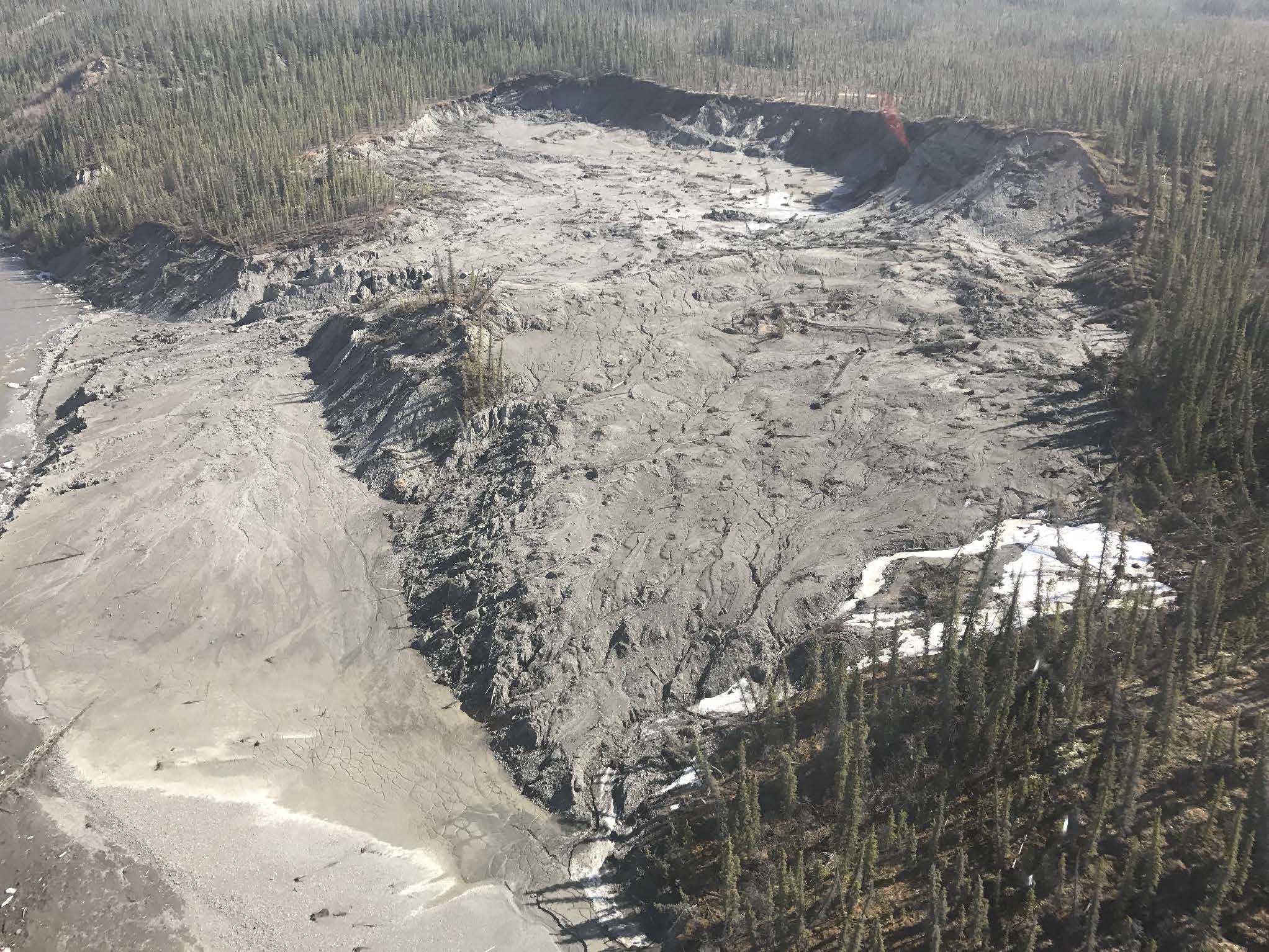
Figure 2. Aerial photo of affected area taken May 16, 2017. The silt on the left of the image appears to have come from the eroded area to the right, building up the eastern bank of the river. Source: Thaw_Slump_Images.pdf companion file.
Selected Imagery
This dataset provides a time series of spatial data showing the expansion of a thaw slump on the E. Fork Chandalar River near Venetie, Alaska from 2008 through 2017.The erosion of vegetated areas was documented by manually digitizing imagery from Landsat 5 (TM), 7 (ETM+), and 8 (OLI) and ESRI basemaps.
The imagery used were acquired on the following dates:
Landsat 5: August 23, 2008, August 17, 2009, July 6, 2011.
Landsat 7: September 22, 2010, June 14, 2012
Landsat 8: June 18, 2013, May 23, 2015, September 3, 2015, June 17, 2016, June 13, 2017, September 17,2017.
ArcMap Imagery Basemap: June 16, 2014
Time Series Development
The time series was created by manually digitizing imagery from ESRI basemaps and Landsat 5 (TM), 7 (ETM+), and 8 (OLI) using a combination of shortwave infrared 2, shortwave infrared 1, red bands.
"7-6-4" band combination and the panchromatic band “band 8” for Landsat 8,
"7-5-3" band combination for Landsat 5 and 7
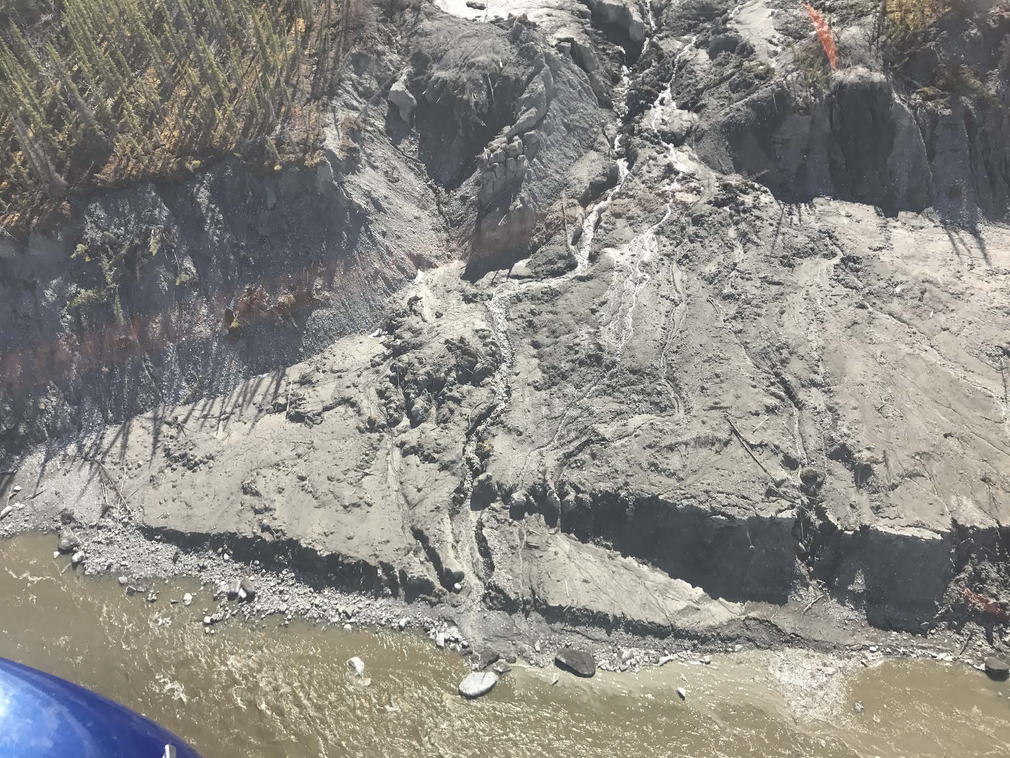
Figure 3. Aerial photo from the same date as Figure 2. Rivulets appear to be forming gullies and accelerating the erosion. Source: Thaw_Slump_Images.pdf companion file.
Data Access
These data are available through the Oak Ridge National Laboratory (ORNL) Distributed Active Archive Center (DAAC).
ABoVE: Annual Thaw Slump Expansion on East Fork Chandalar River, Alaska, 2008-2017
Contact for Data Center Access Information:
- E-mail: uso@daac.ornl.gov
- Telephone: +1 (865) 241-3952
References
Corresponding author: Todd J. Brinkman, University of Alaska Fairbanks, tjbrinkman@alaska.edu