Documentation Revision Date: 2019-09-03
Dataset Version: 1
Summary
For the past five years, through a variety of projects and collaborations, research infrastructure has been developed at a variety of sites around Fairbanks, Alaska. Investment will continue in these sites over the next ten years. The sites are road accessible and represent a variety of ecotype and terrain types common in the boreal biome of interior Alaska.
There is one data file in comma-separated (.csv) format with this dataset. The measurement locations are provided as two companion files, one in shapefile (.shp) format and one in .kmz format for viewing in Google Earth.
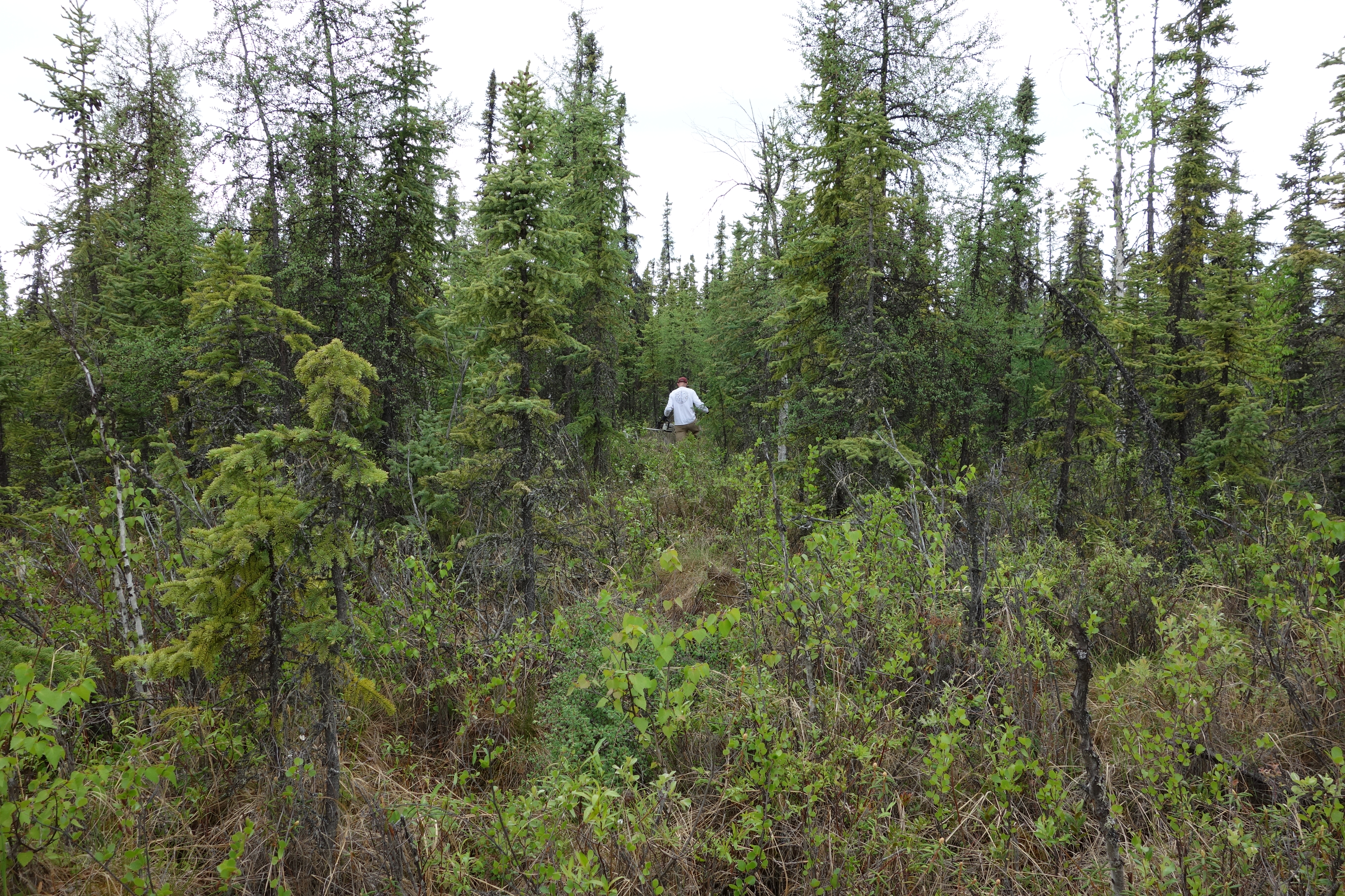
Figure 1. Thaw depths recorded along Farmer's Loop Transect 2. Photo provided by Tom Douglas.
Citation
Douglas, T.A. 2019. ABoVE: Soil Active Layer Thaw Depths at CRREL sites near Fairbanks, Alaska, 2014-2018. ORNL DAAC, Oak Ridge, Tennessee, USA. https://doi.org/10.3334/ORNLDAAC/1701
Table of Contents
- Dataset Overview
- Data Characteristics
- Application and Derivation
- Quality Assessment
- Data Acquisition, Materials, and Methods
- Data Access
- References
Dataset Overview
This dataset provides soil active layer thaw depth measurements collected along transects at three sites near Fairbanks, Alaska, USA. Measurements were made during the late summers of 2014-2018. The sites were located at Creamer's Field, the Permafrost Tunnel, and Farmer's Loop (two transects). Vegetation ecotypes along the transects are also reported. The US Army Corps of Engineers, Cold Regions Research and Engineering Laboratory (CRREL) owns and operates facilities at the Permafrost Tunnel and Farmer's Loop. The sites are suitable for manipulation experiments, installing permanent equipment, and establishing long-term measurements.
For the past five years, through a variety of projects and collaborations, research infrastructure has been developed at a variety of sites around Fairbanks, Alaska. Investment will continue in these sites over the next ten years. The sites are road accessible and represent a variety of ecotype and terrain types common in the boreal biome of interior Alaska.
Project: Arctic-Boreal Vulnerability Experiment
The Arctic-Boreal Vulnerability Experiment (ABoVE) is a NASA Terrestrial Ecology Program field campaign based in Alaska and western Canada between 2016 and 2021. Research for ABoVE links field-based, process-level studies with geospatial data products derived from airborne and satellite sensors, providing a foundation for improving the analysis and modeling capabilities needed to understand and predict ecosystem responses and societal implications.
Related Dataset:
Douglas, T.A., C.A. Hiemstra, and A.J. Barker. 2019. ABoVE: End of Season Snow Depth at CRREL sites near Fairbanks, Alaska, 2014-2019. ORNL DAAC, Oak Ridge, Tennessee, USA. https://doi.org/10.3334/ORNLDAAC/1702
Data Characteristics
Spatial Coverage: Three sites near Fairbanks, Alaska
ABoVE Reference Locations
Domain: Core ABoVE
Grid cells: Ah1Av0.Bh6Bv5.Ch40Cv32
Spatial Resolution: Multiple points. 4 m intervals along transects.
Temporal Coverage: 2014-10-15 to 2018-10-15
Temporal Resolution: Annual
Study Area: All latitudes and longitudes given in decimal degrees
|
Site (Region) |
Westernmost Longitude |
Easternmost Longitude |
Northernmost Latitude |
Southernmost Latitude |
|---|---|---|---|---|
|
Fairbanks, AK |
-147.740241 |
-147.6121684 |
64.951124 |
64.867711 |
Data File Information
There is one data file in comma-separated format (.csv) and two companion files with this dataset.
Table 1. File names and descriptions
|
File name |
Description |
|---|---|
|
Thaw_depth_four_sites_near_fairbanks.csv |
This data file provides 2,270 thaw depth measurements and ecotypes at three sites (4 transects) located near Fairbanks, Alaska during the period 2014 to 2018. Note Coordinate Reference System: EPSG 32606. |
| Companion Files | |
|
active_layer_thaw_depths_all_sites.zip |
Companion file with the measurement locations in shapefile format (shp), provided as a compressed (.zip) file |
|
active_layer_thaw_depths_all_sites.kmz |
Companion file with the measurement locations in .kmz format for viewing in Google Earth |
Table 2. Variables in the data file Thaw_depth_four_sites_near_fairbanks.csv
|
Column |
Units |
Description |
|---|---|---|
|
year |
yyyy |
Year of the measurement |
|
site |
|
Name of field site |
|
northing |
m |
Northing location of measurement, NAD83 / UTM zone 6N |
|
easting |
m |
Easting location of measurement, NAD83 / UTM zone 6N |
|
latitude |
decimal degrees |
Latitude of measurement location |
|
longitude |
decimal degrees |
Longitude of measurement location |
|
thaw_depth |
cm |
Thaw depth-depth of the active layer |
|
type |
|
Ecosystem types at transect sites |
Application and Derivation
The goal is to accumulate a long-term record of thaw depth in the area.
Quality Assessment
Thaw depth measurements were collected along four transects near permanent flags. Location accuracy is about 25 cm as the flags were surveyed with a total station GPS.
Data Acquisition, Materials, and Methods
Thaw depth was measured at three sites (four transects) near Fairbanks, Alaska: Creamer’s Field, Farmer’s Loop transects 1 and 2, and the Permafrost Tunnel (CRREL owns and operates facilities at the Permafrost Tunnel and Farmer’s Loop). The site transects are 400 to 500 m long.
At each site, we established a linear transect, a 2 m wide line cut through the vegetation, and conducted a high resolution Global Positioning System (GPS) survey to establish the ground topography. The transects were sighted to cross the most varied terrain possible.
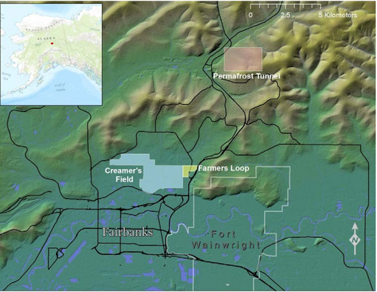
Figure 2. Locations of the Creamer's Field, Farmer's Loop, and Permafrost Tunnel transect sites (photo from Bjella et al., 2015).
Sites are road accessible and represent a variety of ecotype and terrain types which vary along the transects and site to site.
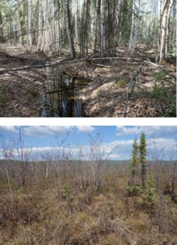
Figure 3. Vegetation along the Creamer’s Field transect at 0-140 m (top) and 200-500 m (lower) (photo from Bjella et al., 2015).
Thaw Depth Measurements
Thaw depth measurements were made as described in Bjella et al. (2015).
Measuring the vertical extent of the active layer is easy but time consuming due to the point-scale nature of the measurement. A roughly 1 cm diameter graduated rod is pushed vertically downward through the vegetation, organic layer, and thawed soil to the point of refusal; and the penetration depth (i.e., vertical distance) is noted. Depth is measured relative to the top of the soil material; i.e., to the base of the vegetation. (CALM method, https://ipa.arcticportal.org/images/stories/Ressources/A_Handbook_on_Periglacial_Field_Methods_20040406.pdf).
This permafrost frost probing can yield heterogeneous results when undulating vegetation or soil features are present. For example, at all of our sites, tussocks composed of sedge material could be as much as 80 cm tall. Whether one probes through, along, or in between a tussock mass can greatly alter the frost probe depth at that location. To address this, we used a survey-grade GPS and installed markers at 4 m intervals along all four of our study-site transects. By probing alongside the markers during the summer, we were able to track the downward migration of the active layer with time. We also were able to consistently quantify active-layer development through a variety of vegetation and terrain materials.
Ecotypes
Vegetation types along the transects were assigned ecotypes: Mixed Forest, Wetland, Tussock Tundra, Disturbed, Moss Spruce Forest, or Eroded. The physiography and moisture modifiers often used in ecotype terminology were dropped.
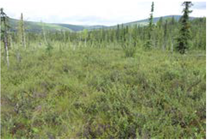
Figure 4. The CRREL Permafrost Tunnel site in Fox, AK, approximately 20 km north of Fairbanks. Photo shows vegetation along the 400-m Permafrost Tunnel transect (photo from Bjella et al., 2015).
Data Access
These data are available through the Oak Ridge National Laboratory (ORNL) Distributed Active Archive Center (DAAC).
ABoVE: Soil Active Layer Thaw Depths at CRREL sites near Fairbanks, Alaska, 2014-2018
Contact for Data Center Access Information:
- E-mail: uso@daac.ornl.gov
- Telephone: +1 (865) 241-3952
References
Bjella, K., S. Arcone, and T. Douglas. Imaging of Ground Ice with Surface-Based Geophysics Cold Regions Research and Engineering Laboratory. 2015. Technical Report. ERDC/CRREL TR-15-14. Available at https://erdc-library.erdc.dren.mil/xmlui/bitstream/handle/11681/5504/ERDC-CRREL-TR-15-14.pdf
Douglas, T.A., M.T. Jorgenson, D.R.N. Brown, S.W. Campbell, C.A. Hiemstra, S.P. Saari, K. Bjella, and A.K. Liljedahl. 2016. Degrading permafrost mapped with electrical resistivity tomography, airborne imagery and LiDAR, and seasonal thaw measurements. Geophysics 81(1). https://doi.org/10.1190/GEO2015-0149.1