Documentation Revision Date: 2018-12-31
Data Set Version: 1
Summary
Grids were subjectively established at all sites. Some of the grids were in homogeneous stands of vegetation that were considered representative of the regional climate or zonal vegetation. Other grids were in stands of vegetation that were regionally extensive. The source species observations and environmental samples were obtained from homogeneous plots/relevés within the grids and at other selected locations. In some cases where the vegetation was more heterogeneous, as for example in patterned ground, areas with frost boils, stone stripes, or closely spaced water tracks, samples were divided into representative microhabitats with each relevé representing a microsite within the grid.
There are 13 data files in comma-separated (.csv) format with this data set.
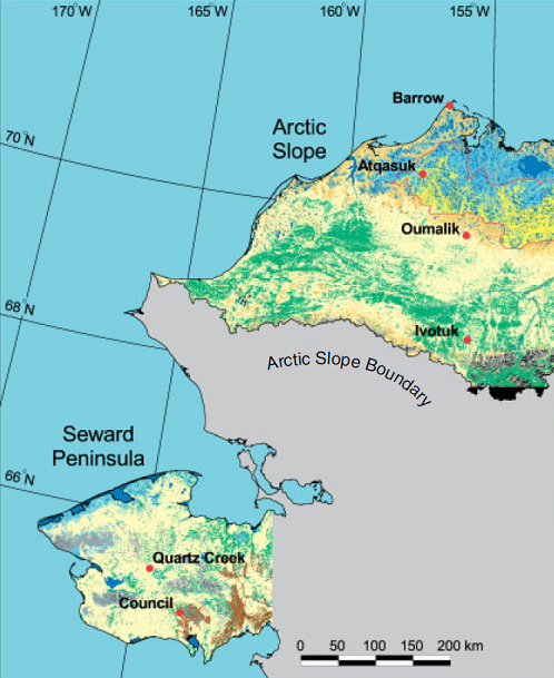
Figure 1. Location map of the ATLAS-1 and ATLAS-2 study sites (from Walker et al., 2003).
Citation
Raynolds, M.K. 2018. Arctic Vegetation Plots ATLAS Project North Slope and Seward Peninsula, AK, 1998-2000. ORNL DAAC, Oak Ridge, Tennessee, USA. https://doi.org/10.3334/ORNLDAAC/1541
Table of Contents
- Data Set Overview
- Data Characteristics
- Application and Derivation
- Quality Assessment
- Data Acquisition, Materials, and Methods
- Data Access
- References
Data Set Overview
This data set provides environmental, soil, and vegetation data collected from study sites on the North Slope and Seward Peninsula of Alaska during the Arctic Transition in Land-Atmosphere System (ATLAS) project. ATLAS-1 sites on the North Slope, located in Barrow, Atqasuk, Oumalik, and Ivotuk, were sampled in 1998-1999. ATLAS-2 sites located at Council and Quartz Creek on the Seward Peninsula were sampled in 2000. Specific attributes include dominant vegetation species and cover, biomass, soil chemistry and moisture, leaf area index (LAI), normalized difference vegetation index (NDVI), topography, and elevation, and plant cover abundance. All data were not collected at all grids.
Grids were subjectively established at all sites. Some of the grids were in homogeneous stands of vegetation that were considered representative of the regional climate or zonal vegetation. Other grids were in stands of vegetation that were regionally extensive. The source species observations and environmental samples were obtained from homogeneous plots/relevés within the grids and at other selected locations. In some cases where the vegetation was more heterogeneous, as for example in patterned ground, areas with frost boils, stone stripes, or closely spaced water tracks, samples were divided into representative microhabitats with each relevé representing a microsite within the grid.
The Pre-ABoVE vegetation plot datasets were curated to create the Alaska Arctic Vegetation Archive (AVA-AK; Walker et al. 2016b, Walker 2013). The AVA-AK is a regional database that is part of the larger Arctic Vegetation Archive (Walker 2016a, Walker et al. 2013, Walker and Raynolds 2011). The database contains vegetation plots from homogeneous plant communities with tables of cover or cover-abundance scores for all species and accompanying environmental site data. Field data were collected using Braun-Blanquet, US National Vegetation Classification protocols, or comparable methods.
Project: Arctic-Boreal Vulnerability Experiment (ABoVE)
The Arctic-Boreal Vulnerability Experiment (ABoVE) iis a NASA Terrestrial Ecology Program field campaign that will take place in Alaska and western Canada between 2016 and 2021. Climate change in the Arctic and Boreal region is unfolding faster than anywhere else on Earth. ABoVE seeks a better understanding of the vulnerability and resilience of ecosystems and society to this changing environment.
Related data sets:
Pre-ABoVE: Arctic Vegetation Plots at Barrow, Alaska, 2012. ORNL DAAC, Oak Ridge, Tennessee, USA. https://doi.org/10.3334/ORNLDAAC/1505
Pre-ABoVE: Arctic Vegetation Plots, Oumalik, Alaska, 1983-1985. ORNL DAAC, Oak Ridge, Tennessee, USA. https://doi.org/10.3334/ORNLDAAC/1506
Pre-ABoVE: Arctic Vegetation Plots at Atqasuk, Alaska, 1975, 2000, and 2010. ORNL DAAC, Oak Ridge, Tennessee, USA. http://dx.doi.org/10.3334/ORNLDAAC/1371
Acknowledgements:
These data files were edited by Donald A. Walker, Amy L. Breen and Lisa A. Druckenmiller at the University of Alaska Fairbanks' Alaska Geobotany Center and obtained via the Arctic Geoecological Atlas (http://arcticatlas.geobotany.org/), which provides access to existing Arctic vegetation plot and map data in support of the ABoVE campaign.
Data Characteristics
Spatial Coverage: North Slope and Seward Peninsula, Alaska
ABoVE Grid Locations:
North Slop sites, ATLAS-1 sites: Ahh1Avv0Bh0Bv0
Seward Peninsula, ATLAS-2 sites: Ahh0Avv0Bh0Bv0
Spatial Resolution: Point resolution
Temporal Coverage: 19980701 to 20000729
Temporal Resolution: Annual
Study Area (These coordinates are the approximate locations of the study sites and may not match the extents of data files. All latitude and longitude given in decimal degrees.)
|
Site |
Westernmost Longitude |
Easternmost Longitude |
Northernmost Latitude |
Southernmost Latitude |
|---|---|---|---|---|
|
Atqasuk |
-157.41238 |
-157.34555 |
70.46432 |
70.44332 |
|
Barrow |
-156.608 |
-156.608 |
71.32193 |
71.32193 |
|
Oumalik |
-156.02 |
-155.899 |
69.86229 |
69.83724 |
|
Ivotuk |
-155.744 |
-153.738 |
68.48702 |
68.47935 |
|
Council |
-163.9407 |
-163.3189 |
64.9383 |
64.7265 |
|
Quartz Creek |
-165.0687 |
-163.5144 |
65.4551 |
64.9704 |
Data File Information
There are 13 data files with this data set in comma-separated (.csv) format. The files provide vegetation species as well as the percent ground cover occupied by the species, soil characterization, plot environmental data, biomass, NDVI, and leaf area index (LAI). All data were not collected at all plots and relevés.
Data not provided in the files are represented as -9999 or "not_provided" (also could represent not applicable).
Table 1. Data files
|
Data File Name |
Description |
|---|---|
|
atlas-1_environmental_data.csv |
Environmental characterization data for ATLAS-1 research plots |
|
atlas-1_lai.csv |
Leaf Area Index (LAI) data collected from ATLAS-1 research grids |
|
atlas-1_biomass.csv |
Raw biomass data data collected from ATLAS-1 research grids |
|
atlas-1_ndvi_lai_biomass_ivotuk.csv |
NDVI, LAI, and biomass measurements at Ivotuk and provided for each of the four grids by vegetation type (MAT - moist acidic tundra (Ivotuk 1), MNT - moist nonacidic tundra (Ivotuk 3), ST - shrub tundra (Ivotuk 2), MT - mossy tussock tundra(Ivotuk 4)) |
|
atlas-1_spectral_ivotuk.csv |
Spectral reflectance measurements at wavelengths from 340.8 to 1061.78 nm, ~1.4 nm resolution. Data were collected at Ivotuk and provided for each of the four grids by vegetation type (MAT - moist acidic tundra (Ivotuk 1), MNT - moist nonacidic tundra (Ivotuk 3), ST - shrub tundra (Ivotuk 2), MT - mossy tussock tundra(Ivotuk 4)) |
|
atlas-1_species_data.csv |
Species cover data in comma separated (.csv) format. Both the author's determination and the current taxonomy according to the Panarctic Species List (PASL) |
|
atlas-2_species.csv |
Species cover data in comma separated (.csv) format. Both the author's determination and the current taxonomy according to the Panarctic Species List (PASL) |
|
atlas-2_environmental_data.csv |
Environmental characterization data for Council and Quartz Creek research plots |
|
atlas-2_lai.csv |
Leaf Area Index (LAI) data collected from the Council and Quartz Creek research grids |
|
atlas-2_biomass.csv |
Biomass measurements from Quartz Creek grids |
|
atlas-2_soil_texture.csv |
Soil texture data |
|
atlas-2_soil_moisture.csv |
Soil moisture data |
|
atlas-2_soil_chemistry.csv |
Soil chemistry data |
ATLAS-1 Data files
The ATLAS-1 study plots were on the North Slope and include Barrow, Atqasuk, Oumalik, and Ivotuk.
Table 2. Variables in the file atlas-1_environmental_data.csv
These data describe the environment of the plots and were collected during July 1998 and July 1999. Refer to the companion file atlas-1_envlegend.pdf for the ordinal scale descriptions and associated codes.
| Column number | Variable | Units/format | Description |
|---|---|---|---|
| 1 | site | ATLAS study site | |
| 2 | field_plot_number | numeric | Plot number as provided by the author |
| 3 | date | yyyymmdd | Date plot was investigated |
| 4 | latitude | decimal degrees | Plot latitude |
| 5 | longitude | decimal degrees | Plot longitude |
| 6 | elevation | m | Elevation in meters |
| 7 | surficial_geology | scalar | Surficial geology |
| 8 | surficial_geomorphology | scalar | Surficial geomorphology |
| 9 | topographic_position | scalar | Topographic position |
| 10 | slope | degrees | Slope of plot |
| 11 | aspect | degrees | Aspect |
| 12 | releve_shape | Relevé shape | |
| 13 | releve_area | m2 | Relevé area |
| 14 | organic_ layer_ depth | cm | Depth of the soil organic layer |
| 15 | soil_ph | Soil pH | |
| 16 | soil_texture | % | Soil texture |
| 17 | plant_community_name | % | Percent of trees in the plant community |
| 18 | cover_low_shrubs | % | Percent of low shrubs in the plant community |
| 19 | cover_dwarf_shrubs | % | Percent of dwarf shrubs in the plant community |
| 20 | cover_prostrate_ dwarf_ shrub | % | Percent of prostrate dwarf shrubs in the plant community |
| 21 | cover_evergreen_shrubs | % | Percent of evergreen shrubs in the plant community |
| 22 | cover_deciduous_shrubs | % | Percent of deciduous shrubs in the plant community |
| 23 | cover_forbs | % | Percent of forbs in the plant community |
| 25 | cover_graminoids | % | Percent of graminoids in the plant community |
| 26 | cover_lichens | % | Percent of plot that was lichen |
| 27 | cover_bryophytes | % | Percent of plot that was bryophytes |
| 28 | cover_horsetails | % | Percent of plot that was horsetails |
| 29 | cover_rocks | % | Percent of plot that was bare rock |
| 30 | cover_bare_soil | % | Percent of plot that was bare soil |
| 31 | cover_water | % | Percent of plot that had water |
| 32 | cover_frost_scars | % | Percent of plot that had frost scars |
| 33 | total_dead | % | Percent of plot that had dead vegetation |
| 34 | canopy_ht | cm | Mean canopy height |
| 35 | remarks | comments |
Table 3. Variables in the file atlas-1_biomass.csv
Raw biomass data collected June 27-July 18, 1999.
| Column Number | Variable | Units/format | Description |
|---|---|---|---|
| 1 | site | Site name | |
| 2 | vegetation_type | Vegetation type=MNT, Moist NonAcidic Tundra, or MAT, Moist Acidic Tundra | |
| 3 | grid_plot_number | Grid plot number | |
| 4 | moss | g/m2 | Moss biomass |
| 5 | lichen | g/m2 | Lichen biomass |
| 6 | equisetum | g/m2 | Equisetum biomass |
| 7 | forb | g/m2 | Forb biomass |
| 8 | deciduous_shrub_stem | g/m2 | Deciduous shrub stem biomass |
| 9 | live_deciduous_leaf | g/m2 | Live deciduous leaf biomass |
| 10 | dead_deciduous_leaf | g/m2 | Dead deciduous leaf biomass |
| 11 | evergreen_shrub_stem | g/m2 | Evergreen shrub stem biomass |
| 12 | live_evergreen_leaf | g/m2 | Live evergreen leaf biomass |
| 13 | dead_evergreen_leaf | g/m2 | Dead evergreen leaf biomass |
| 14 | live_graminoid | g/m2 | Live graminoid biomass |
| 15 | dead_graminoid | g/m2 | Dead graminoid biomass |
| 16 | deciduous_reproduction | g/m2 | Biomass from deciduous reproduction |
| 17 | evergreen_reproduction | g/m2 | Biomass from evergreen reproduction |
| 18 | total | g/m2 | Total biomass |
| 19 | litter | g/m2 | Total biomass from litter |
| 20 | total_evergreen_shrub | g/m2 | Total biomass from evergreen shrub |
| 21 | total_deciduous_shrub | g/m2 | Total biomass from deciduous shrub |
| 22 | total_graminoid | g/m2 | Total biomass from graminoids |
| 23 | total_vascular | g/m2 | Total biomass from vascular plants |
| 25 | total_shrub | g/m2 | Total biomass from shrubs |
Table 4. Variables in the data file atlas-1_lai.csv
These are LAI data for Atqasuk, Barrow and Oumalik grids collected between July 5-17, 1999 using a LICOR-2000 Plant Canopy Analyzer.
| Column number | Variable | Units/format | Description |
|---|---|---|---|
| 1 | date | yyyymmdd | Date of LAI measurements |
| 2 | grid | Research grid where measurements were made | |
| 3 | grid_point | Research grid point where measurements were made | |
| 4 | lai | LAI |
Table 5. Variables in the file atlas-1_ndvi_lai_biomass_ivotuk.csv
The data are for each gridpoint at each of the four grids at Ivotuk. The first four rows in the data file represent the grid (Ivotuk 1-4), grid point, vegetation type at the grid, and sampling period through columns 1-column 228. The biomass, NDVI, and LAI data are in column 1 below the grid information.
| Variables and grid-column #1 | Units/format | Description |
|---|---|---|
| grid_name | Grid name: Ivotuk_1, 2, 3 ,and 4; columns 2-28 | |
| grid_point | Grid points; columns 2-28 | |
| vegetation_type | Vegetation type at the grid: Ivotuk 1=MAT - moist acidic tundra; Ivotuk 2=ST - shrub tundra, Ivotuk 3= MNT - moist nonacidic tundra, Ivotuk 4= MT - mossy tussock tundra. Columns 2-28 | |
| sampling_period | There were six sampling periods at each of the four grids covering June, July, and August, 1999. Columns 2-28 | |
| graminoid_alive | g/m2 | Live graminoid biomass |
| graminoid_dead | g/m2 | Dead graminoid biomass |
| graminoid_total | g/m2 | Total graminoid biomass |
| moss | g/m2 | Moss biomass |
| lichen | g/m2 | Lichen biomass |
| horsetails | g/m2 | Horsetails biomass |
| forb | g/m2 | Forb biomass |
| deciduous_shrub_woody | g/m2 | Deciduous shrub woody biomass |
| deciduous_shrub_live_foliar | g/m2 | Deciduous shrub live biomass |
| deciduous_shrub_dead_foliar | g/m2 | Deciduous shrub dead biomass |
| evergreen_shrub_woody | g/m2 | Evergreen shrub woody biomass |
| evergreen_shrub_live foliar | g/m2 | Evergreen shrub live foliar biomass |
| evergreen_shrub_dead_foliar | g/m2 | Evergreen shrub dead foliar biomass |
| shrub_total | g/m2 | Total shrub biomass |
| shrub_total_live | g/m2 | Total live shrub biomass |
| shrub_total_live_foliar | g/m2 | Total live shrub foliar biomass |
| shrub_total_dead | g/m2 | Total dead shrub biomass |
| live | g/m2 | Total live biomass |
| dead | g/m2 | Total dead biomass |
| grand | g/m2 | Grand total biomass |
| NIR (725-1060) | Near infrared | |
| red (580-680) | Red | |
| NIR-Red | Near infrared-red | |
| NIR + Red | Near infrared+red | |
| NDVI (NIR-R/NIR+R) | Calculated NDVI | |
| LAI | LAI |
Example data:
| grid_name | IVOTUK 1 | IVOTUK 1 | IVOTUK 1 |
| grid_point | J2 | H5 | I8 |
| vegetation_type | MAT | MAT | MAT |
| sampling_period | 1 | 1 | 1 |
| graminoid_alive | 1.79 | 0.29 | 0.05 |
| graminoid_dead | 6.03 | 2.17 | 0.82 |
| graminoid_total | 7.82 | 2.46 | 0.87 |
| moss | 7.03 | 2.11 | 21.85 |
| lichen | 0.165 | 8.87 | 2.78 |
| horsetails | 0 | 0 | 0 |
| forb | 0.005 | 0 | 0 |
Table 6. Variables in the file atlas-1_spectral_ivotuk.csv
The spectral reflectance data are for each gridpoint at each of the four grids at Ivotuk. The first four rows in the data file represent the grid (Ivotuk 1-4), grid point, vegetation type at the grid, and sampling period through columns 1-column 228. Measurements were made with a FieldSpec Pro spectroradiometer. Column 1 provides the wavelengths from 340.8 to 1061.78 nm at ~1.4 nm resolution for the respective row values.
| Variable | Description |
|---|---|
| IVOTUK (1-4) | Study site Ivotuk |
| grid_name | Ivotuk grids 1-4 |
| grid_point | Point on the grid where measurement was made |
| sampling_period | There were six sampling periods at each of the four grids covering June, July, and August, 1999 |
| vegetation_type | Vegetation type at the grid: Ivotuk 1=MAT - moist acidic tundra; Ivotuk 2=ST - shrub tundra, Ivotuk 3= MNT - moist nonacidic tundra, Ivotuk 4= MT - mossy tussock tundra |
| wavelength_nm | Wavelength in nanometers |
Example data:
| IVOTUK (1-4) | ||||||||
| grid_name | IVOTUK 1 | IVOTUK 1 | IVOTUK 1 | IVOTUK 2 | IVOTUK 2 | IVOTUK 2 | IVOTUK 3 | IVOTUK 3 |
| grid_point | J2 | H5 | I8 | D2 | E7 | D9 | J6 | G9 |
| sampling_period | 1 | 1 | 1 | 1 | 1 | 1 | 1 | 1 |
| vegetation_type | MAT | MAT | MAT | ST | ST | ST | MNT | MNT |
| wavelength_nm |
Table 7. Variables in the files atlas-1_species_data.csv and atlas-2_species_data.csv
These files contain species cover data for the ATLAS-1 and ATLAS-2 vegetation studies. Both the author's determination and the current taxonomy according to the Panarctic Species List (PASL) are listed. Taxa are listed in alphabetical order according to the accepted PASL name.
| Column number | Column header | Description |
|---|---|---|
| 1 | PASL_taxon_scientific_name | Current nomenclature according to the Panarctic Species List (PASL) |
| 2 | PASL_taxon_scientific_name_author | Current nomenclature according to the Panarctic Species List (PASL) with the data authors name |
| 3 | dataset_taxon | Data set taxonomy |
| 4-90 | TURBOVEG_plot_accession_number and dataset_plot_number_author |
Two rows of column headers which are plot numbers/accession numbers. The first row is TURBOVEG accession numbers.
The 2nd row is dataset_plot_number_author, the plot numbers as named in the original data set. Species cover classes are the old Braun-Blanquet cover-abundance scale: r= (rare) + (common, but less than 1 percent) |
ATLAS-1 data note: In three instances, taxa were lumped into a single taxon in the PASL: 1) Cladonia squamosa (Cladonia squamosa and Cladonia subsquamosa), 2) Dicranum spadiceum (Dicranum angustum and Dicranum spadiceum), 3) Polytrichastrum alpinum (Polytrichastrum alpinum and Polytrichastrum fragile).
ATLAS-2 data note: In two instances, taxa were lumped into a single taxon in the PASL: 1) Cladonia stellaris (Cladonia stellaris and Cladonia stellaris v. aberrans), and 2) Dicranum spadiceum (Dicranum angustum and Dicranum spadiceum). In the report, there was environmental data but no species data for a plot CC-C, and species data but no environmental or location data for plot C-F. Both of these plots were dropped due to lack of information.
ATLAS-2 data files
The author’s plots were numbered following a letter-number, and letter system, where the first letter equals the location of grid: C=Council, BH=Blueberry Hill, QC=Quartz Creek, CC=Cassiope Cone, or Lava, the number equals the plot number, and the letter(s), if present, A, B, C etc., equal the plot microsite.
Table 8. Variables in the file atlas-2_environmental_data.csv
These data describe the environment of the plots and were collected during July, 2000. Refer to the companion file atlas-2_envlegend_metadata.pdf for the code and scalar value definitions
| Column number | Variable | Units/format | Description |
|---|---|---|---|
| 1 | releve | Relevé as provided by the author in form of a letter and number combination | |
| 2 | turboveg_ num | TURBOVEG accession number | |
| 3 | date | yyyymmdd | Date plot was investigated |
| 4 | latitude | decimal degrees | Plot latitude |
| 5 | longitude | decimal degrees | Plot longitude |
| 6 | plot_size | mxm | Size of plot in meters x meters |
| 7 | slope | degrees | Slope of plot |
| 8 | aspect | degrees | Direction-south, east, north, or west |
| 9 | elevation | m | Elevation |
| 10 | surficial_geology | scalar | Surficial geology |
| 11 | surficial_geomorphology | scalar | Surficial geomorphology |
| 12 | glacial_ geology | code | Glacial geology of the plot area |
| 13 | topographic_position | code | Topographic position |
| 14 | surface_stability | code | Surface stability with regard to avalanches, surface movements due to floods, etc. noted using an ordinal scale |
| 15 | site_moisture | scalar | Site moisture |
| 16 | organic_layer_depth | cm | Depth of the soil organic layer |
| 17 to 27 | thaw_depth_1 to thaw_depth_11 | cm | Thaw depth measurements |
| 28 | thaw_depth | cm | Mean thaw depth |
| 29 | thaw_depth_std_deviation | Mean thaw depth, standard deviation | |
| 30 | soil_units | code | |
| 31 | soil_ph | Soil pH | |
| 32 | soil_texture | Soil texture | |
| 33 | exposure | scalar | Estimated exposure to winds |
| 34 | duration_snow | scalar | Estimated snow duration recorded using an ordinal scale |
| 35 | site_disturbance | scalar | Site disturbance by animals and humans. Comments provided |
| 36 | microsites | code | Microsites and description if present |
| 37 | plant_community_name | Names of plant communities | |
| 38 | cover_trees | % | Percent of trees in the plant community |
| 39 | cover_tall_shrubs | % | Percent of tall shrubs in the plant community |
| 40 | cover_low_shrubs | % | Percent of low shrubs in the plant community |
| 41 | cover_dwarf_shrubs | % | Percent of dwarf shrubs in the plant community |
| 42 | cover_evergreen_shrubs | % | Percent of evergreen shrubs in the plant community |
| 43 | cover_deciduous_shrubs | % | Percent of deciduous shrubs in the plant community |
| 44 | cover_forbs | % | Percent of forbs in the plant community |
| 45 | cover_graminoids | % | Percent of graminoids in the plant community |
| 46 | cover_lichens | % | Percent of plot that was lichen |
| 47 | cover_bryophytes | % | Percent of plot that was bryophytes |
| 48 | cover_rocks | % | Percent of plot that was bare rock |
| 49 | cover_prostrate_ dwarf_ shrub | % | Percent of plot that was prostrate dwarf shrub |
| 50 | cover_bare_soil | % | Percent of plot that was bare soil |
| 51 | cover_water | % | Percent of plot that had water |
| 52 | cover_frost_scars | % | Percent of plot that had frost scars |
| 53 | total_dead | % | Percent of plot that had dead vegetation |
| 54 | canopy_ht | cm | Mean canopy height |
| 55 | comments | Comments | |
| 56 | field_observer | Field observer name | |
| 57 | site_location | Location of the site | |
| 58 | additional_description | Additional description of location |
Table 9. Variables in the file atlas-2_lai.csv
LAI measurements made at Quartz Creek on July 28 and 29, 2000.
| Column number | Variable | Units/format | Description |
|---|---|---|---|
| 1 | grid | Sampling grid | |
| 2 | date | yyyymmdd | Date of LAI measurement |
| 3 | lai | LAI | |
| 4 | mean | Mean LAI | |
| 5 | std_error | Standard error of the LAI measurements (+ or -) |
Table 10. Variables in the file atlas-2_biomass.csv
Biomass measurements made at Quartz Creek on July 28 and 29, 2000.
| Column number | Variable | Units/format | Description |
|---|---|---|---|
| 1 | grid | Sampling grid | |
| 2 | location | Location on the grid. In addition, the mean and standard error are listed after the locations | |
| 3 | moss | g/m2 | Moss |
| 4 | lichen | g/m2 | Lichen |
| 5 | forb | g/m2 | Forb |
| 6 | horsetail | g/m2 | Horsetail |
| 7 | Graminoid_live | g/m2 | Live graminoid |
| 8 | Graminoid_dead | g/m2 | Dead graminoid |
| 9 | shrub_foliage_live | g/m2 | Live shrub foliage |
| 10 | shrub_foliage_dead | g/m2 | Dead shrub foliage |
| 11 | shrub_stem_live | g/m2 | Live shrub stem |
| 12 | shrub_stem_dead | g/m2 | Dead shrub stem |
| 13 | litter | g/m2 | Litter |
| 14 | Total_no_litter | g/m2 | Total (without litter) |
Table 11. Variables in the file atlas-2_soil_texture.csv
Soil samples were collected in July, 2000. Refer to the companion file atlas-2_soilslegend.pdf for code definitions.
| Column number | Variable | Units/format | Description |
|---|---|---|---|
| 1 | releve | Relevé at the plot | |
| 2 | date | yyyymmdd | Date soil was sampled |
| 3 | classification | Soil texture classification | |
| 4 | depth | cm | Soil depth |
| 5 | horizon | Soil horizon | |
| 6 | color | Munsell color | Soil color |
| 7 | structure_grade | code | Soil structure grade |
| 8 | structure_classification | code | Soil size classification |
| 9 | structure_type | code | Soil structure type |
| 10 | gravel | percent | Percent of gravel in the soil |
| 11 | consistency | code | Soil consistency |
| 12 | texture | code | Soil texture |
| 13 | boundaries_distinct | code | Distinct boundaries |
| 14 | boundaries_topography | code | Topography |
| 15 | collected | y/n | Sample collected |
| 16 | notes | Notes |
Table 12. Variables in the file atlas-2_soil_moisture.csv
Soil samples were collected in July, 2000. Refer to the companion file atlas-2_soilslegend.pdf for code definitions.
| Column number | Variable | Units/format | Description |
|---|---|---|---|
| 1 | releve | Relevé where sample was taken | |
| 2 | sample_num | Sample number | |
| 3 | horizon | Soil horizon | |
| 4 | wet_wt | gm | Soil wet weight |
| 5 | dry_wt_tare | gm | |
| 6 | tare_wt | gm | |
| 7 | dry_wt | gm | Soil dry weight |
| 8 | water_wt | gm | Water weight of soil |
| 9 | moisture | % | Soil moisture |
Table 13. Variables in the file atlas-2_soil_chemistry.csv
Soil data samples were collected in July, 2000 .Refer to the companion file atlas-2_soilslegend.pdf for code definitions.
| Column number | Variable | Units/format | Description |
|---|---|---|---|
| 1 | releve | Relevé where sample was taken | |
| 2 | horizon | Soil horizon | |
| 3 | ph | Soil pH | |
| 4 | p | ppm | Soil phosphorus |
| 5 | k | ppm | Soil potassium |
| 6 | ca | ppm | Soil calcium |
| 7 | mg | ppm | Soil magnesium |
| 8 | na | ppm | Soil sodium |
| 9 | c | % | Soil carbon |
| 10 | n | % | Soil nitrogen |
| 11 | loss_on_ignition | % | |
| 12 | sand | % | Soil sand content |
| 13 | silt | % | Soil silt content |
| 14 | clay | % | Soil clay content |
Companion Files
Table 14. Companion files with this data set.
| Companion files | Description |
|---|---|
| atlas_walker_permafrost_periglac_thawdepth.pdf | Report which provides additional information regarding the ATLAS-1 data collection methods, particularly for thaw depth |
| atlas-1_edwards_westrnalaska_grids.pdf | Provides information on the ATLAS-1 study including accuracy assessments and code information for scalar data |
| atlas-1_envlegend.pdf | Provides the codes and scalar definitions used in the ATLAS-1 data files |
| atlas-1_riedel_ndvi_lai.pdf | Report which provides additional information regarding the ATLAS-1 NDVI, LAI, and biomass measurement methods |
| atlas-1_plotphotos.pdf | Provides photos of the ATLAS-1 plots |
| atlas-2_raynolds_2002_datareport.pdf | Provides additional information on the data collection methods and data tables for the ATLAS-2 project |
| atlas-2_soilslegend.pdf | Provides the codes and scalar definitions used in the ATLAS-2 soil data files |
| atlas-2_envlegend.pdf | Provides the codes and scalar definitions used in the ATLAS-2 environmental data files |
| atlas-2_photos.pdf | Provides photos of the plots at the ATLAS-2 sites |
| ATLAS_veg_plots.pdf | A pdf of this guide document |
Application and Derivation
These data could be useful to climate change studies and land use environmental studies.
Quality Assessment
Refer to the companion files listed in the Section 2 of this document.
Data Acquisition, Materials, and Methods
Site description
This data set provides environmental, soil, and vegetation data collected as part of the Arctic Transition in Land-Atmosphere System (ATLAS) project, ATLAS-1 and ATLAS-2. The ATLAS-1 study plots were on the North Slope and include Barrow, Atqasuk, Oumalik, and Ivotuk. ATLAS-2 sites included Council and Quartz Creek on the Seward Peninsula.
Grids were subjectively established at all sites. Some of the grids were in homogeneous stands of vegetation that were considered representative of the regional climate or zonal vegetation. Other grids were in stands of vegetation that were regionally extensive.
The source species and environmental data for the plots were obtained from homogeneous areas of dominant vegetation within the grids. In some cases where the vegetation was more heterogeneous, as for example in patterned ground, areas with frost boils, stone stripes, or closely spaced water tracks, samples were divided into representative microhabitats with each relevé representing a microsite within the grid. These microsites were labeled with the letters A, B, C as needed (Edwards et al., 2000).
Methods-ATLAS-1
The grids at Atqasuk (A-1 (1 grid)), Barrow (B-1 (1 grid)), Ivotuk (I-1, I-2, I-3, I-4 (4 grids)) were 100 x 100-m; grids at Oumalik (O-1 and O-2 (2 grids)) were 50 m x 50-m.
Plot cover
Percent cover values for lifeforms were collected at all relevés. Complete plant species composition data were obtained, using the Braun-Blanquet method.
Vegetation
Vegetation from 15 relevé within eight different grids at Barrow, Atqasuk, Ivotuk and Oumalik were described. At Atqasuk (A-1 (1 grid)), Barrow (B-1 (1 grid)), and Ivotuk (I-1, I-2, I-3, I-4 (4 grids)), 100 x 100-m grids were established; 50 x 50-m grids (O-1 and O-2 (two grids)) were established at Oumalik. Subjectively located within the grids were one or more circular relevés (10-m in diameter, except for Oumalik, where they were 5-m in diameter).
The 15 relevés represent microsites within the grids related to, for example patterned ground features. These microsites were labeled with the letters A, B, C as needed. Plots occur in 14 plant communities within five broad habitat types including: a) willow shrub vegetation of riparian areas and warm habitats (south-facing slopes) (one plot), b) sedge grass and dwarf shrub mire and fen vegetation (two plots), c) bog vegetation, acidic mires, including tussock tundra (six plots), d) frost boil vegetation in nonacidic tundra (one plot), and e) dry and mesic dwarf-shrub and graminoid vegetation on non-acidic substrate (five plots).
All of the data are for the SW corners of the grids except for O-1A and O-1B, where they came from the center of the grids, and Atqasuk where the location for the point was not given.
Leaf Area Index: Atqasuk, Barrow and Oumalik
LAI at the Atqasuk, Barrow and Oumalik grids were collected between July 5-17, 1999, using a LICOR-2000 Plant Canopy Analyzer. An above-canopy reading (control) was followed by four below-canopy readings (which were taken above the moss layer) at 33 random points within each grid. At each point, the four below-canopy measurements were taken along the axes of the grid at 1-meter from the grid point. All measurements were taken facing away from the sun and an umbrella was used to shade the sensor on sunny days. LAI was calculated for each point (Edwards et al., 2000).
NDVI, LAI, and biomass at Ivotuk
In 1999 spectral and biomass data were collected from each of the four grids at Ivotuk, each grid representative of a different vegetation type during the 1999 growing season. Each grid was 100 x 100-m, with each grid point represented by a letter (A-K) and number (1-11) combination. Sampling periods were 1 - June 6-11; 2 - June 18-25; 3 - July 2-10; 4 - July 15-26; 5 - July 29 to August 6; 6 - August 13-20; 7 - August 22-26.
- Spectral reflectance data (range 340-1060 nm, ~1.4 nm resolution) were collected using an Analytical Spectral Devices, FieldSpec Pro. Measurements were taken at 20 random points within each grid; the same 20 points were used throughout the growing season. Data were collected preferentially during clear sky conditions and close to midday (10AM-3PM). The fiber-optic sensor with a 25 degree field-of-view was held at nadir above each relevé at 1-m height, yielding a circular footprint of about 0.35 m2. Each measurement is the average of five samples taken at 1-second intervals. White reference calibrations were made prior to each measurement using a Spectralon plate, as well as a dark reference (Riedel et al., 2005).
- LAI was measured using a LI-COR LAI-2000 Plant Canopy Analyzer. Above- and below-canopy radiation measurements were made with a ‘fish eye’ optical sensor with a five-ring 148 degree angle-of-view. Below-canopy measurements were made just above the moss layer. LAI was calculated using a model of radiative transfer in vegetation canopies and then stored in the unit data logger. At each of the 20 grid points, one above-canopy reading was taken, and four below-canopy readings were taken (1-m north, east, south and west of the grid point) to yield a single LAI value.
Above-ground phytomass was collected from 10 randomly selected 20-cm x 50-cm plots within each grid. Phytomass sampling occurred near, but not within, the footprints of LAI and NDVI measurements. On the fourth sample period (15–26 July), the number of phytomass plots harvested was doubled for MAT and MT. On the fifth sample period (27 July to 7 August), the number of phytomass plots harvested was doubled for MNT and ST. Vascular plants were clipped at the top of the moss surface; mosses were clipped at the base of the green layer. Phytomass samples were sorted into six main categories (horsetails, other forbs, graminoids, lichens, mosses, and shrubs). The graminoid and shrub samples were sorted further into subcategories. Graminoid phytomass was divided into live and dead material. Shrub phytomass was divided into evergreen and deciduous, which were then separated into woody, foliar live, and foliar dead components. Dead material was combined into a single pool, referred to as standing dead (Riedel et al., 2005).
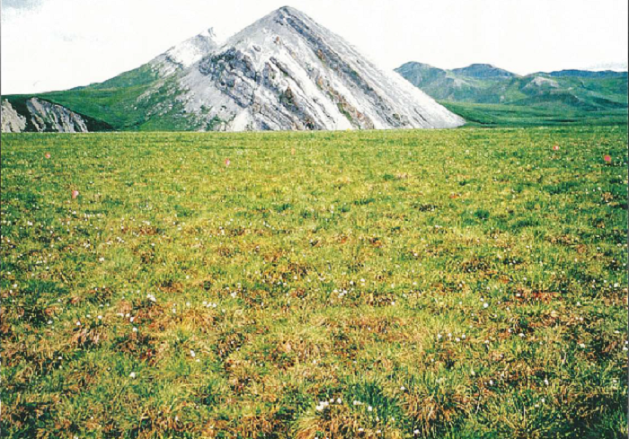
Figure 2. Ivotuk-4 grid. This grid has homogeneous acidic tussock tundra with abundant Sphagnum moss (photo from Edwards et al., 2000).
Biomass
One 20-cm x 50-cm quadrat of biomass was harvested for each grid point/date combination (except for Ivotuk 2 and 4). Vascular biomass was clipped at the top of the moss layer, and the moss was clipped at the bottom of the green layer. Biomass was sorted into the following vegetation types: algae, moss, lichen, horsetail, other forbs, graminoids, deciduous shrubs, and evergreen shrubs. Graminoids were further sorted into live and dead, and shrubs were further sorted into wood, foliar live, foliar dead. Biomass samples were dried and weighed (Edwards et al., 2000).
Methods-ATLAS-2
The grids at Council and Quartz Creek were 100 x 100-m. The author’s plots were numbered following a letter- number, and letter system, where the first letter equals the location of the grid.
- Council : C=Council, BH=Blueberry Hill, CC=Cassiope Cone
- Quartz Creek: QC=Quartz Creek or Lava,
The number equals the plot number, and the letter(s), if present, A, B, C etc., equals the plot microsite.
All data were collected 26 June to 29 July, 2000 unless otherwise noted.
Plot cover
Percent cover values for lifeforms were collected at all relevés. Complete plant species composition data were obtained, using the Braun-Blanquet method. Lichen and moss identifications were verified by scientists from the Komarov Botanical Institute.
Plot environmental data
A total of 52 relevés were collected from the grids and other sites. A variety of environmental site data were collected from each relevé including landforms, surficial geology, surficial geomorpholgy, microsites, site moisture, soil moisture, glacial geology, topographic position, soil unit, exposure to wind, estimated duration, animal and human disturbance, and stability.
Vegetation
Forty-five plots were assigned to five different arctic community types: a) tall forb and shrub vegetation on mesic-moist soil (13 plots); b) dwarf-shrub heath and low shrub vegetation on acidic poor substrate (13 plots); c) bog vegetation, acidic mires, including tussock tundra (eight plots); d) dry and mesic dwarf-shrub heath and graminoid vegetation on non-acidic tundra (nine plots); and e) lichen communities on silicate rocks (two plots). Of the remaining seven plots, six are undefined forest types (C1, C4-A, C-9, C-A, C-C, C-E) and plot C-F is not included due to insufficient community data.
Four grids were established at Quartz Creek and three at Council. The grids were established in zonal vegetation and other vegetation types that locally cover large areas. The data from the grids include vegetation type (or species in forests) and microsite at each of the 121 grid points, and height of the vegetation, thickness of the moss layer, thickness of the soil organic horizons, phytomass and leaf-area index from a subset of grid points.
Thirty-one vegetation plots were sampled from sites at Council, Quartz Creek, and along the roads between these locations. Some of these were in complexes of vegetation that contained up to three plant communities, so a total of 52 stands of vegetation (relevés) were sampled.
In most cases the relevés were approximately 10 x 10-m, though the size was increased in six heterogeneous areas, and conformed to microsite variations. All the grids contained at least one relevé. At each grid, vegetation heterogeneity was sampled at 121 gridpoints, spaced every 10 meters (A1-K11). In the Council forest grid (C1), and the shrub grid (C3) the point was described as either tree canopy, shrub canopy, or clearing; and the tree or shrub species at the point was noted. At the other grids, the vegetation type and the microsite type were noted at each point. The vegetation height was measured at 20 randomly chosen gridpoint. The depth of the live and dead nonvascular layer was measured, and the dominant species noted. The general height of the vascular vegetation was measured and the dominant species noted. The height of the microrelief was measured.
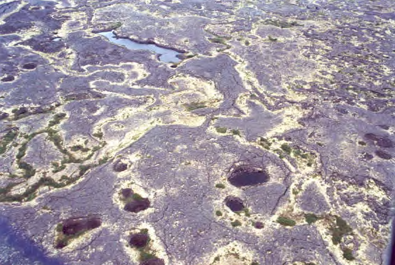
Figure 3. Seward Peninsula Lava site. Patches of vegetation occur on more weathered areas of the lava flow (photo from Raynolds et al., 2002).
Leaf Area Index
Leaf area index (LAI) was measured at each of the four grids at Quartz Creek at every 10 meters along a 100-m transect using a LICOR LAI-2000 Plant Canopy Analyzer. An above-canopy reading (control) was followed by four below-canopy readings, taken above the moss layer along the axes of the grid at 1 m from the point. All measurements were taken facing away from the sun, and a sun screen was used to shade the sensor on sunny days. These measurements were repeated at 33 random points within each grid. A 90 degree field-of-view shield was used to prevent interference from the observers. LAI was calculated for each point, and mean LAI for each grid was calculated. All measurements were made on July 28 and 29, 2000 (Raynolds et al., 2002).
Biomass
Clip harvests were collected for above ground biomass estimates at three Quartz Creek grids. At 10 random locations within in the grid, all above-ground biomass was clipped from a 20 x 50-cm area. In the shrub plot (QC3), the shrubs were sampled in a 1 x 1-m area, while the understory was sampled in a 20 x 50-cm area. The clip harvests were sorted by major plant functional type (moss, lichen, forb, horsetail, deciduous shrub, evergreen shrub, graminoid) in the field. All vascular plants were clipped at the top of the moss surface. Green stem bases below the moss surface were also included in the clip harvest. Mosses were clipped at the base of the green portion. The samples were frozen and returned to the UAF laboratory where they were further sorted into live and dead categories. Both shrub categories were divided into their foliar, reproductive, and stem components. Biomass samples were dried to constant weight at 50 degrees C, and the dry weights were then used to estimate total g/m2 for each grid and functional type with the grid (Raynolds et al., 2002).
Soil Description
Soil samples were collected at each grid. At the Council grids, random points were chosen along six rows. At the Quartz Creek grids, random points were chosen along each of the 11 rows (A-K). The organic horizons (Oi, Oe, and Oa ) were measured and described. Soils for analysis were collected in soil cans from the top of the B horizon. Samples were dried and weighed to calculate soil moisture. Chemical and size composition were analyzed at the Palmer Experimental Laboratory. Measurements were made from 2000-07-11 to 2000-07-29.
Thaw depth: ATLAS-1 and ATLAS-2 sites
Data from Barrow, Atqasuk, Oumalik, Ivotuk, Quartz Creek, and Council were collected in 1999. At Barrow, Atqasuk, and Quartz Creek data from the nearby CALM grids (Brown et al., 2000) were used.
The thaw depth was monitored using a blunt tipped steel probe that was inserted into the soil to the point of contact with hard frozen soil. Measurements were taken at 10 m intervals on the 100 x 100-m grids (121 measurements per grid), and at 0.5 m intervals on the 10-m grids (Walker et al., 2003). Thaw depth data can also be found in related datasets archived at the ORNL DAAC. See the Overview section of this document.
Refer to the companion file atlas-2_raynolds_2002_datareport.pdf for additional information.
This data set was provided by the GINA repository at http://geobotanical.portal.gina.alaska.edu/catalogs/9781-alaska-arctic-vegetation-archive-atlas-1-atqa and http://geobotanical.portal.gina.alaska.edu/catalogs/10671-alaska-arctic-vegetation-archive-atlas-2-veget.
Data Access
These data are available through the Oak Ridge National Laboratory (ORNL) Distributed Active Archive Center (DAAC).
Arctic Vegetation Plots ATLAS Project North Slope and Seward Peninsula, AK, 1998-2000
Contact for Data Center Access Information:
- E-mail: uso@daac.ornl.gov
- Telephone: +1 (865) 241-3952
References
Brown, J., K.M. Hinkel, and F.E. Nelson. 2000. The circumpolar active layer monitoring (CALM) program: research designs and initial results. Polar Geography 24: 165–258. http://dx.doi.org/10.1080/10889370009377698
Edwards, E. J., A. Moody, and D. A. Walker. 2000. A western Alaskan transect to examine interactions of climate, substrate, vegetation, and spectral reflectance: ATLAS grids and transects, 1998-1999. ARCSSATLAS-Northern Ecosystem Analysis and Mapping Laboratory data report.Institute of Arctic Biology, University of Alaska Fairbanks, Fairbanks, Alaska, USA.
Raynolds, M.K., C.R. Martin, D.A. Walker, A. Moody, and C. Thayer-Snyder. 2002.Atlas Vegetation Studies Seward Peninsula, Alaska, 2000. Vegetation, Soil, and Site Information, with Seward Vegetation Map. ARCSS-ATLAS-AGC data report, Alaska Geobotany Center, University of Alaska Fairbanks, Fairbanks, Alaska USA.
Riedel, S.M., H.E. Epstein, D.A. Walker, D.L. Richardson, M.P. Calef, E. Edwards, and A. Moody. 2005. Spatial and temporal heterogeneity of vegetation properties among four tundra plant communities at Ivotuk, Alaska, U.S.A. Arctic, and Alpine Research.37:25-33. https://doi.org/10.1657/1523-0430(2005)037[0025:SATHOV]2.0.CO;2
Walker, D.A., G.J. Jia, H.E. Epstein, M.K. Raynolds, F.S. Chapin III, C. Copass, L.D. Hinzman, J.A. Knudson, H.A. Maier, G.J. Michaelson, F. Nelson, C.L. Ping, V.E. Romanovsky and N. Shiklomanov. 2003. Vegetation-soil-thaw-depth relationships along a low-arctic bioclimate gradient, Alaska: synthesis of information from the ATLAS studies. Permafrost and Periglacial Processes. 14:103-123. https://dx.doi.org/10.1002/ppp.452