Documentation Revision Date: 2025-03-20
Dataset Version: 1
Summary
There are three files in portable document format (.pdf) in this dataset.
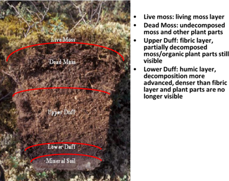
Figure 1. Organic soil profile showing distinction of live moss, dead moss, upper duff and lower duff. The image is from file ABoVE_Soil_Moisture_Sampling_Protocol_R3.pdf.
Citation
Bourgeau-Chavez, L.L., K.R. Bosse, A.F. Poley, and M.J. Battaglia. 2025. ABoVE: Soil Moisture and ALT Field Collection Protocols and Probe Calibration. ORNL DAAC, Oak Ridge, Tennessee, USA. https://doi.org/10.3334/ORNLDAAC/2373
Table of Contents
- Dataset Overview
- Data Characteristics
- Application and Derivation
- Quality Assessment
- Data Acquisition, Materials, and Methods
- Data Access
- References
Dataset Overview
This dataset contains soil moisture sampling protocols and calibration algorithms for Campbell Scientific Hydrosense-I and II units used at burned and unburned sites in the ABoVE project domain. The soil moisture sampling protocol provides guidance for sampling in situ soil moisture to relate to synthetic aperture radar (SAR) data collections. Two additional documents describe algorithms for calibrating handheld Hydrosense units used to measure volumetric water content in soils. One calibration document applies to organic soils in fire-affected sites of the Northwest Territories and Alaska. A second document provides calibrations for samples collected in non-burned tundra, boreal bog, fen, upland deciduous and conifer sites located in Alberta and tundra sites in Alaska.
Project: Arctic-Boreal Vulnerability Experiment (ABoVE)
The Arctic-Boreal Vulnerability Experiment (ABoVE) is a NASA Terrestrial Ecology Program field campaign being conducted in Alaska and western Canada, for 8 to 10 years, starting in 2015. Research for ABoVE links field-based, process-level studies with geospatial data products derived from airborne and satellite sensors, providing a foundation for improving the analysis, and modeling capabilities needed to understand and predict ecosystem responses to, and societal implications of, climate change in the Arctic and Boreal regions.
Related Publication
Bourgeau-Chavez, L.L., G.C. Garwood, K. Riordan, B.W. Koziol, J. and Slawski. 2010. Calibration algorithm development for selected water content reflectometers to burned and non-burned organic soils of Alaska. International Journal of Wildland Fire 19:961-975. http://doi.org/10.1071/WF07175
Related Dataset
Moore, M., K. Schaefer, E.E. Hoy, M. Auclair, K. Bakian-Dogaheh, M.J. Battaglia, K. Bennett, W.R. Bolton, L.L. Bourgeau-Chavez, A.E. Bredder, D. Chen, R.H. Chen, A.C. Chen, J. Chen, D. Chiasson, R. Chitra-tarak, L.K. Clayton, A. Collins, L. Cornette, J. Dann, E. Devoie, M. Dominico, T.A. Douglas, S. Gagnon, S.E. Grelick, P. Griffith, J. He, E. Jafarov, G. Iwahana, L.K. Jenkins, E.S. Kasischke, S. Kim, P.B. Kirchner, B. Lecavalier, J. Ledman, S. Liben, L. Liu, T.V. Loboda, S. Ludwig, M.J. Macander, N. Matsui, R.J. Michaelides, M. Moghaddam, S. Natali, S.K. Panda, A.D. Parsekian, M. Pearce, W. Quinton, A.V. Rocha, H. Rodenhizer, R. Roy-léveillée, N. Saravanan, Z. Sauve, S.R. Schaefer, E.A.G. Schuur, O. Sonnentag, T.D. Sullivan, A. Tabatabaeenejad, L. Thomas, B. Thorne, K. Turner, K. Wang, C.J. Wilson, H.A. Zebker, T. Zhang, Y. Zhao, and S. Zwieback. 2024. ABoVE: Soil Moisture and Active Layer Thickness, Alaska and NWT, Canada, 2005-2022. ORNL DAAC, Oak Ridge, Tennessee, USA. https://doi.org/10.3334/ORNLDAAC/2369
Acknowledgement
This work was supported by the NASA Terrestrial Ecology Program’s Arctic-Boreal Vulnerability Experiment (ABoVE).
Data Characteristics
Spatial Coverage: ABoVE project study sites; Alaska and Canada
The protocols described herein were used to take point measurements of soil characteristics at ABoVE field sites.
Data File Information
There are three files with this dataset in portable document format (.pdf) (Table 1).
Table 1. File descriptions
| Data File | Description |
|---|---|
| ABoVE_Soil_Moisture_Sampling_Protocol_R3.pdf | This file provides guidance on the layout of sampling points at field sites, methods for recording soil characteristics and extracting a soil core sample, and important things to consider when sampling in situ soil characteristics. |
| NASA_ABOVE_Calibration_Summary_2018.pdf | This file describes the algorithms for calibrating the Campbell Scientific handheld Hydrosense-I and II units used to measure in situ volumetric water content in fire-affected organic soils. It contains calibration results for fen, bog, and tundra soils at depths of 6, 12, and 20 cm. |
| Probe_CalibrationSummaryDoc2_UnburnedSites _Hydrosense_I_II.pdf | This file describes the algorithms for calibrating the Campbell Scientific Hydrosense-I and II units in unburned peatland and upland sites in Red Earth Creek, Alberta, and tundra sites in Sagwon, Alaska. This file provides calibrations for five soil groups found in boreal forest and tundra ecosystems. |
Application and Derivation
The information provided would be useful for future field soil sampling efforts and calibration of the Campbell Scientific Hydrosense I and II handheld soil moisture probes.
Quality Assessment
Scatterplots in the two calibration documents display variation in data used to derive calibration curves. Tables list the R2 and standard errors associated with calibration equations.
Data Acquisition, Materials, and Methods
In situ data on soil moisture, soil depth, and active layer thickness (ALT) were collected from ABoVE field sites. Plots were established within the footprints of imagery gathered by SAR (Miller et al., 2023). The resulting data were used to develop models for estimating soil conditions from SAR data (e.g., Chen et al., 2022). This dataset holds three documents that describe methods for field sampling.
ABoVE_Soil_Moisture_Sampling_Protocol_R3.pdf outlines the methods for setting up a field study site and protocols for sampling soil characteristics.
NASA_ABOVE_Calibration_Summary_2018.pdf and Probe_CalibrationSummaryDoc2_UnburnedSites_Hydrosense_I_II.pdf describe methods for calibrating the handheld Campbell Scientific Hydrosense I and Hydrosense II meters used in the field to measure volumetric water content (VWC) in soils (Bourgeau-Chavez et al., 2010). The Hydrosense I and Hydrosense II meters use frequency domain reflectometry (FDR; Ruelle and Laurent, 2008) to measure soil moisture content based on the frequency at which an electronic pulse is reflected back from the end of metal probe rods (Figure 2). Hydrosense meters use probe rods of 12 cm or 20 cm in length. The oscillation velocity of the reflected pulse depends on soil water levels but is also influenced by clay content, organic matter, temperature, and other soil characteristics. Therefore, calibration is needed to obtain the most accurate measurements of VWC when an FDR device is used with varying soil types.
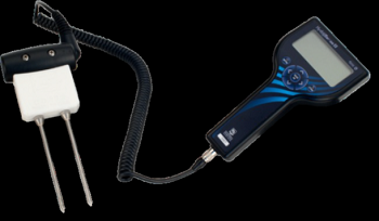
Figure 2. Handheld Hydrosense probe with 12-cm rods. Image from ABoVE_Soil_Moisture_Sampling_Protocol_R3.pdf.
Brief summaries of the content of the files are provided below. Refer to the files for additional information.
ABoVE_Soil_Moisture_Sampling_Protocol_R3.pdf
This document provides guidance for setting up sites and sampling in situ soil moisture to relate to SAR data collections. Topics include:
- The procedure to establish a new 100 m x 100 m field site.
- The procedure for establishing a site relevant for SAR imagery having 5- to 15-m spatial resolution.
- The procedure for Alternate Sites sampled as 30 m x 30 m plots relevant for UAVSAR and Radarsat-2 imagery.
- The procedure for Alternate Sites sampled as transects of homogeneous areas at least 20 m wide.
- Overview of data collected during field sampling (e.g., dominant vegetation, burn status, ALT, soil profile, etc.).
- Example field data sheet.
- Methods for measuring the soil profile (e.g., Figure 1).
NASA_ABOVE_Calibration_Summary_2018.pdf
This document describes the Hydrosense calibration methods and results for organic soils affected by wildfires in Northwest Territories (NWT), Canada, and Alaska, U.S. in 2016.
Probe_CalibrationSummaryDoc2_UnburnedSites_Hydrosense_I_II.pdf
This document describes the Hydrosense calibration results for unburned peatland and upland sites in Red Earth Creek, Alberta, and tundra sites in Sagwon, Alaska. It contains calibration results for five soil groups (Table 2).
Table 2. Description of soils grouped by ecotype for calibration in Probe_CalibrationSummaryDoc2_UnburnedSites_Hydrosense_I_II.pdf.
| Group | Boreal/Tundra Ecotypes | General guidelines | |
|---|---|---|---|
| Boreal | A | Upland Deciduous (UD), Feathermoss dominant Lowland Conifer (CON) and Treed Fen (TF) |
Feathermoss dominant <7 cm Live/dead moss over 6-17+ cm duff or for deciduous sites lower duff and silty clay |
| B | Sphagnum dominant Bog and Open Fen (OF) | Sphagnum dominant >7 cm or live/dead moss over >9 cm duff | |
| Tundra | C | Tundra Tussocks ONLY | Calibration is for probing the tussocks themselves and not the soil |
| D | Tundra Tussock and Tundra Tussock Shrub sites | >8 cm live/dead moss and or upper duff over 12-24 cm lower duff | |
| E | Non-tussock Tundra: Sedge and Shrub Tundra | <2 cm live/dead moss over 7-20 cm lower duff over clay |
Both calibration documents include tables of parameters for calibration equations for different meters, probe lengths, and ecosystem types. A user should select the equation for the correct meter (Hydrosense I or II) and probe length that was used in the field; meters and probe lengths are not interchangeable.
Data Access
These data are available through the Oak Ridge National Laboratory (ORNL) Distributed Active Archive Center (DAAC).
ABoVE: Soil Moisture and ALT Field Collection Protocols and Probe Calibration
Contact for Data Center Access Information:
- E-mail: uso@daac.ornl.gov
- Telephone: +1 (865) 241-3952
References
Bourgeau-Chavez, L.L., G.C. Garwood, K. Riordan, B.W. Koziol, J. and Slawski. 2010. Calibration algorithm development for selected water content reflectometers to burned and non-burned organic soils of Alaska. International Journal of Wildland Fire 19:961-975. http://doi.org/10.1071/WF07175
Chen, R.H., R.J. Michaelides, J. Chen, A.C. Chen, L.K. Clayton, K. Bakian-Dogaheh, L. Huang, E. Jafarov, L. Liu, M. Moghaddam, A.D. Parsekian, T.D. Sullivan, A. Tabatabaeenejad, E. Wig, H.A. Zebker, and Y. Zhao. 2022. ABoVE: Active Layer Thickness from Airborne L- and P- band SAR, Alaska, 2017, Ver. 3. ORNL DAAC, Oak Ridge, Tennessee, USA. https://doi.org/10.3334/ORNLDAAC/2004
Miller, C.E., P. Griffith, E.E. Hoy, N. Pinto, Y. Lou, S. Hensley, B. Chapman, J.L. Baltzer, K. Bakian-Dogaheh, W.R. Bolton, L.L. Bourgeau-Chavez, R.H. Chen, B-H. Choe, L.K. Clayton, T.A. Douglas, N.H.F. French, J.E. Holloway, G. Hong, L. Huang, G. Iwahana, L.K. Jenkins, J.S. Kimball, T.V. Loboda, M.C. Mack, P. Marsh, R.J. Michaelides, M. Moghaddam, A.D. Parsekian, K. Schaefer, P. Siqueira, D. Singh, A. Tabatabaeenejad, M.R. Turetsky, R. Touzi, E. Wig, P. Wilson, C.J. Wilson, S.D. Wullschleger, Y. Yi, H.A. Zebker, Y. Zhang, Y. Zhao, and S.J. Goetz. 2023. Summary of the ABoVE L-band and P-band Airborne SAR Surveys, 2012-2022. ORNL DAAC, Oak Ridge, Tennessee, USA. https://doi.org/10.3334/ORNLDAAC/2150
Ruelle, P. and J.P. Laurent. 2008. CS616 (CS515) water content reflectometer. Pp. 101-111 (Chapter 7) in Field Estimation of Soil Water Content: a practical guide to methods, instrumentation and sensor technology. Training Course Series No. 30; IAEA-TCS-30. International Atomic Energy Agency; Vienna. https://www.iaea.org/publications/7801/field-estimation-of-soil-water-content
Schaefer, K., L.K. Clayton, M.J. Battaglia, L.L. Bourgeau-Chavez, R.H. Chen, A.C. Chen, J. Chen, K. Bakian-Dogaheh, T.A. Douglas, S.E. Grelick, G. Iwahana, E. Jafarov, L. Liu, S. Ludwig, R.J. Michaelides, M. Moghaddam, S. Natali, S.K. Panda, A.D. Parsekian, A.V. Rocha, S.R. Schaefer, T.D. Sullivan, A. Tabatabaeenejad, K. Wang, C.J. Wilson, H.A. Zebker, T. Zhang, and Y. Zhao. 2024. ABoVE: Soil Moisture and Active Layer Thickness, Alaska and NWT, Canada, 2005-2022. ORNL DAAC, Oak Ridge, Tennessee, USA. https://doi.org/10.3334/ORNLDAAC/2369