Documentation Revision Date: 2024-09-09
Dataset Version: 1
Summary
This dataset has two files in cloud optimized GeoTIFF format.
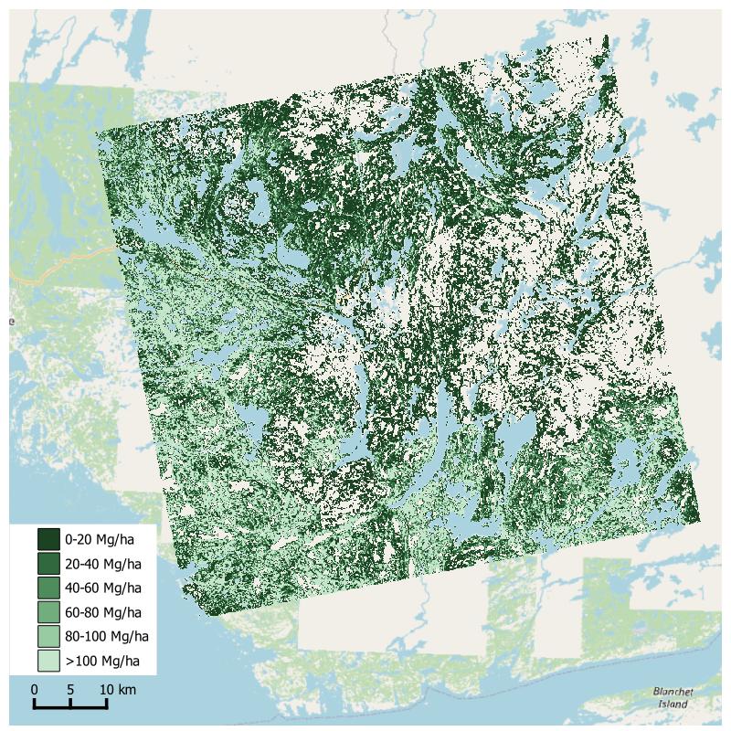
Figure 1. Estimated aboveground biomass for region northeast of Great Slave Lake and east of Yellowknife, Northwest Territories, Canada. Source: 001001_mean_optimal_clr.tif
Citation
Kraatz, S., L.L. Bourgeau-Chavez, M.J. Battaglia, A. Poley, and P. Siqueira. 2024. Aboveground Biomass from SAR, Great Slave Lake Region, NWT, 2019. ORNL DAAC, Oak Ridge, Tennessee, USA. https://doi.org/10.3334/ORNLDAAC/2365
Table of Contents
- Dataset Overview
- Data Characteristics
- Application and Derivation
- Quality Assessment
- Data Acquisition, Materials, and Methods
- Data Access
- References
Dataset Overview
This dataset holds aboveground biomass (ABG) estimates for areas in the Great Slave Lake Region in the Northwest Territories of Canada for 2019. ABG was estimated from L-band synthetic aperture radar (SAR) data obtained from JAXA's Advanced Land Observing Satellite-2 (ALOS-2/PALSAR-2) and supplemented with data from NASA's airborne Uninhabited Aerial Vehicle SAR (UAVSAR) instrument. SAR data were collected from 2017 to 2021. In situ AGB measurements at 14 plots sampled in 2019 were used to calibrate a logarithmic regression to relate the radar datasets to in situ AGB data. Then, AGB was mapped over available ALOS-2 tiles. The estimates are provided in 20-Mg ha-1 bins at 1-ha resolution.
Project: ABoVE
The Arctic-Boreal Vulnerability Experiment (ABoVE) is a NASA Terrestrial Ecology Program field campaign being conducted in Alaska and western Canada, for 8 to 10 years, starting in 2015. Research for ABoVE links field-based, process-level studies with geospatial data products derived from airborne and satellite sensors, providing a foundation for improving the analysis, and modeling capabilities needed to understand and predict ecosystem responses to, and societal implications of, climate change in the Arctic and Boreal regions.
Related Publication:
Kraatz, S., BourgeauâChavez, L., Battaglia, M., Poley, A., & Siqueira, P. (2022). Mapping and scaling of in situ above Ground Biomass to regional extent with SAR in the Great Slave Region. Earth and Space Science, 9(12), e2022EA002431. https://doi.org/10.1029/2022EA002431
Related Datasets:
Bourgeau-Chavez, L.L., M.J. Battaglia, P. Siqueira, C. Weinstein, S. Rose, H. Smith, D. Uhelski, and D.J.L. Vander Bilt. 2022. ABoVE: Post-Fire and Unburned Vegetation Community and Field Data, NWT, Canada, 2019. ORNL DAAC, Oak Ridge, Tennessee, USA. https://doi.org/10.3334/ORNLDAAC/1900
- The dataset contains measurements at 14 field sites sampled in 2019 used in this study.
Acknowledgements:
This work was supported with funding from the NASA Science Team for the NISAR Mission (grants NNX16AK59G, 80NSSC19K1497), the NASA Terrestrial Ecology Arctic-Boreal Vulnerability Experiment (grant 80NSSC19M0107) and US Dept of Agriculture’s Agricultural Research Service (USDA-ARS, grant 58-8042-8-072).
Data Characteristics
Spatial Coverage: Great Slave Lake Region, Northwest Territories, Canada
Spatial Resolution: 100 m
Temporal Coverage: nominal year 2019. Radar data spanned 2017 - 2021. In situ field data from 2019.
Temporal Resolution: annual
Study Areas: Latitude and longitude are given in decimal degrees.
| Site | Westernmost Longitude | Easternmost Longitude | Northernmost Latitude | Southernmost Latitude |
|---|---|---|---|---|
| Northwest Territories, Canada | -118.1706 | -112.2862 | 62.9107 | , 60.6332 |
Data File Information
The dataset holds two files in cloud optimized GeoTIFF (COG) format that hold classes of estimated aboveground biomass.
mosaic_bilinear_optimal_clr.tif is a mosaic of multiple ALOS-2 tiles covering the area west of Great Slave Lake.
001001_mean_optimal_clr.tif covers an ALOS-2 tile of the northeast of Great Slave Lake.
GeoTIFF characteristics:
- Coordinate reference system: UTM zones 11 and 12 using WGS 84 datum (EPSG 32611 and 32612)
- Spatial resolution: 100 m nominal
- Pixel values: categories of aboveground biomass density (Table 1)
- Data type: integer byte
Table 1. Pixel values in GeoTIFFs.
| Pixel value | Aboveground biomass category |
|---|---|
| 0 | No data |
| 1 | 0 to 20 Mg ha-1 |
| 2 | >20 to 40 Mg ha-1 |
| 3 | >40 to 60 Mg ha-1 |
| 4 | >60 to 80 Mg ha-1 |
| 5 | >80 to 100 Mg ha-1 |
| 6 | >100 Mg ha-1 |
Application and Derivation
These data provide estimates of aboveground biomass useful for studies of vegetation structure, carbon storage, and effect of wildfire disturbances.
Quality Assessment
Models for estimating AGB from synthetic aperture radar were calibrated using radar cross section (RCS) values and in situ estimates of AGB for 14 sites. RCS values were aggregated at three spatial scales, and those models were compared to determining the optimal level of areas of aggregation (AOA). For two sites, in situ AGB data were outliers relative to the radar data and difficult to fit. As result, the RMSE for all data was about 60 Mg ha-1. When the two worst performing sites were omitted from model calibration, model fit improved with resulting RMSE values of 32, 15 and 21 Mg ha-1 for the 0.1-, 4-, and 14-ha AOA, respectively.
See Kraatz et al. (2022) for details.
Data Acquisition, Materials, and Methods
This study includes areas located to the west and northeast of Great Slave Lake in Northwest Territories of Canada (Figure 2). This region is home to marshes, swamps, peatlands, and forests. Dominant tree species are black spruce, jack pine, white spruce, and trembling aspen. This region experienced an extreme wildfire season in 2014 that impacted the study area (Whitman et al., 2018). In situ measurements of aboveground biomass (AGB) were derived from data from 14 field sites sampled in 2019 (Bourgeau-Chavez et al., 2022) as part of NASA ABoVE project. There were two 10-m x 10-m sampling plots per site.
Radar data were obtained from the Japan Aerospace Exploration Agency (JAXA) and NASA’s Jet Propulsion Laboratory (JPL/Caltech). This study primarily used L-band synthetic aperture radar (SAR) from JAXA’s ALOS-2 PALSAR-2 (ALOS-2) space-borne platform. These data were augmented with data from NASA’s Uninhabited Aerial Vehicle SAR (UAVSAR) airborne platform. SAR data were processed using ISCE Docker Tools v1.0.0 (Kraatz 2022).
A logarithmic regression model (Mitchard et al., 2009) was developed to relate in-situ AGB measurements to SAR backscatter:
y = a*ln(AGB) + b,
where a and b are constants, y = SAR backscatter in dB, and AGB units = biomass in Mg ha-1. The model calibration approach used SAR data aggregated at three spatial scales: small (~0.1 ha), medium (~3.5 ha), and large (~14 ha) areas of aggregation (AOA). Model fit and accuracy were assessed for each of these scales. After excluding two sites with outlier AGB values, the medium-AOA model provided the best model fit with the lowest RMSE.
The medium AOA model was applied across the ALOS-2 tiles to estimate AGB at 1-ha spatial resolution. For the region west of Great Slave Lake (Figure 2), estimates from multiple tiles were mosaiced together. The AGB estimates were assigned to 20 Mg ha-1 bins; COG pixel values code for these bins (Table 1). When the model returned a negative AGB estimate (usually over water), pixel values were assigned as nodata (0).
See Kraatz et al. (2022) for details of methods.
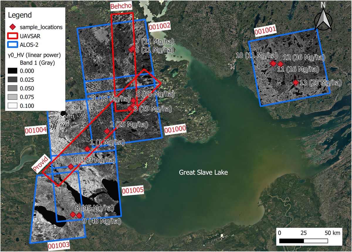
Figure 2. Aboveground biomass (AGB) sampling sites around the Great Slave Lake, Northwest Territories, Canada. AGB values from in situ measurements conducted in 2019 are given in parentheses. Sites are labeled according to site id and in situ AGB estimates. Blue and red outlines indicate the extents of ALOS-2 Palsar-2 (ALOS-2) and NASA’s UAVSAR tiles. Source: Kraatz et al. (2022).
Data Access
These data are available through the Oak Ridge National Laboratory (ORNL) Distributed Active Archive Center (DAAC).
Aboveground Biomass from SAR, Great Slave Lake Region, NWT, 2019
Contact for Data Center Access Information:
- E-mail: uso@daac.ornl.gov
- Telephone: +1 (865) 241-3952
References
Bourgeau-Chavez, L.L., M.J. Battaglia, P. Siqueira, C. Weinstein, S. Rose, H. Smith, D. Uhelski, and D.J.L. Vander Bilt. 2022. ABoVE: Post-Fire and Unburned Vegetation Community and Field Data, NWT, Canada, 2019. ORNL DAAC, Oak Ridge, Tennessee, USA. https://doi.org/10.3334/ORNLDAAC/1900
Kraatz, S. 2022. sgk0/isce_docker_tools: v1.0.0. Zenodo. https://doi.org/10.5281/zenodo.7237027
Kraatz, S., BourgeauâChavez, L., Battaglia, M., Poley, A., & Siqueira, P. (2022). Mapping and scaling of in situ above Ground Biomass to regional extent with SAR in the Great Slave Region. Earth and Space Science, 9(12), e2022EA002431. https://doi.org/10.1029/2022EA002431
Mitchard, E. T. A., S. S. Saatchi, I. H. Woodhouse, G. Nangendo, N. S. Ribeiro, M. Williams, C. M. Ryan, S. L. Lewis, T. R. Feldpausch, and P. Meir. 2009. Using satellite radar backscatter to predict above-ground woody biomass: A consistent relationship across four different African landscapes. Geophysical Research Letters 36:L23401. https://doi.org/10.1029/2009gl040692
Whitman, E., M. Parisien, D. K. Thompson, R. J. Hall, R. S. Skakun, and M. D. Flannigan. 2018. Variability and drivers of burn severity in the northwestern Canadian boreal forest. Ecosphere 9:e02128. https://doi.org/10.1002/ecs2.2128