Documentation Revision Date: 2025-06-10
Dataset Version: 1
Summary
There is one data file in comma separated values (*.csv) format in this dataset.
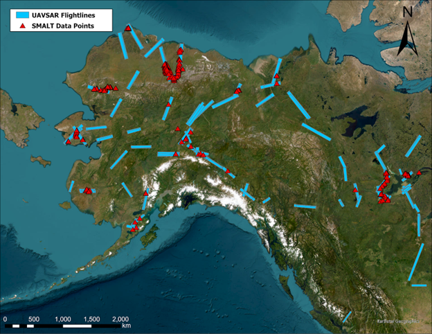
Figure 1. Map indicating the location of the data locations and their relationship to UAVSAR flight data swaths (Miller et al., 2024). Map created in ArcGIS Pro (Redlands, CA).
Citation
Moore, M.A., K. Schaefer, L.K. Clayton, E.E. Hoy, M. Auclair, K. Bakian-Dogaheh, M.J. Battaglia, K. Bennett, W.R. Bolton, L.L. Bourgeau-Chavez, A.E. Bredder, D. Chen, R.H. Chen, A.C. Chen, J. Chen, D. Chiasson, R. Chitra-tarak, A. Collins, L. Cornette, J. Dann, E. Devoie, M. Dominico, T.A. Douglas, S. Gagnon, S.E. Grelick, P. Griffith, J. He, G. Iwahana, E. Jafarov, L.K. Jenkins, E.S. Kasischke, S. Kim, P.B. Kirchner, B. Lecavalier, J. Ledman, S. Liben, L. Liu, T.V. Loboda, S. Ludwig, M.J. Macander, N. Matsui, R.J. Michaelides, M. Moghaddam, S. Natali, S.K. Panda, A.D. Parsekian, M. Pearce, W. Quinton, A.V. Rocha, H. Rodenhizer, P. Roy-Léveillée, N. Saravanan, Z. Sauve, S.R. Schaefer, E.A.G. Schuur, O. Sonnentag, T.D. Sullivan, A. Tabatabaeenejad, L. Thomas, B. Thorne, K. Turner, K. Wang, C.J. Wilson, H.A. Zebker, T. Zhang, Y. Zhao, and S. Zwieback. 2025. ABoVE: Soil Moisture and Active Layer Thickness in Alaska, USA and Canada, 2005-2022. ORNL DAAC, Oak Ridge, Tennessee, USA. https://doi.org/10.3334/ORNLDAAC/2369
Table of Contents
- Dataset Overview
- Data Characteristics
- Application and Derivation
- Quality Assessment
- Data Acquisition, Materials, and Methods
- Data Access
- References
- Dataset Revisions
Dataset Overview
This dataset provides soil thaw depth and moisture measurements and dielectric properties measured by different research teams at sites in Alaska, U.S., and the Northwest Territories, Canada. There are multiple observations per site and 528,703 total observations. The dataset includes 223,230 observations of active layer thickness measured by mechanical probing (9.8%) or ground penetrating radar (GPR) (90.2%). Approximately 179,154 volumetric water content (VWC) measurements were collected using GPR (2.0%), HydroSense I and II probes (8.8%), in situ loggers (89.2%), and DualEM (<1.0%). Metadata includes the location, time, geospatial coordinates, sampling technique, measurement teams, and field team contact information. Measurements were typically collected in August and September near the end of the thaw season and cover the period from 2005 to 2022.
This dataset, referred to as field measurements of Soil Moisture and Active layer Thickness (SMALT) (Schaefer et al., 2021), was developed for work in Clayton et al. (2021) where it is referred to as field measurements of Soil Moisture and Active layer Thickness (SMALT) (Schaefer et al., 2021). It has been expanded in Version 2 to comprise a comprehensive dataset of NASA Arctic-Boreal Vulnerability Experiment (ABoVE) field campaign measurements of soil moisture and active layer thickness, including logger data of relevance to Uninhabited Aerial Vehicle Synthetic Aperture Radar (UAVSAR) acquisitions. This updated dataset includes 175,000 new observations from in situ loggers (83.8%) and manual probing (16.2%). A majority of field probed measurements were collected in coordination with UAVSAR L- and P-band flights for the purpose of assessing SAR inferences of soil moisture and active layer thickness (Miller et al., 2024). This dataset contains measurements collected at study sites in or near Barrow, Seward Peninsula, the North Slope, Fairbanks, Coldfoot, Noatak River, the Yukon-Kuskokwim (YK) Delta in southwestern Alaska, near Delta Junction, Alaska, US, and the Mackenzie River Delta and near Great Slave Lake in the Northwest Territories in Canada. A significant portion of these data observations were coincident in space and time with NASA ABoVE airborne campaign UAVSAR flights.
Project: ABoVE
The Arctic-Boreal Vulnerability Experiment (ABoVE) is a NASA Terrestrial Ecology Program field campaign being conducted in Alaska and western Canada, for 8 to 10 years, starting in 2015. Research for ABoVE links field-based, process-level studies with geospatial data products derived from airborne and satellite sensors, providing a foundation for improving the analysis, and modeling capabilities needed to understand and predict ecosystem responses to, and societal implications of, climate change in the Arctic and Boreal regions.
Related Publication
Clayton, L.K., K. Schaefer, M.J. Battaglia, L. Bourgeau-Chavez, J. Chen, R.H. Chen, A. Chen, K. Bakian-Dogaheh, S. Grelik, E. Jafarov, L. Liu, R.J. Michaelides, M. Moghaddam, A.D. Parsekian, A.V. Rocha, S.R. Schaefer, T. Sullivan, A. Tabatabaeenejad, K. Wang, C.J. Wilson, H.A. Zebker, T. Zhang, and Y. Zhao. 2021. Active layer thickness as a function of soil water content. Environmental Research Letters 16:055028. https://doi.org/10.1088/1748-9326/abfa4c
Related Datasets
Schaefer, K., L.K. Clayton, M.J. Battaglia, L.L. Bourgeau-Chavez, R.H. Chen, A.C. Chen, J. Chen, K. Bakian-Dogaheh, T.A. Douglas, S.E. Grelick, G. Iwahana, E. Jafarov, L. Liu, S. Ludwig, R.J. Michaelides, M. Moghaddam, S. Natali, S.K. Panda, A.D. Parsekian, A.V. Rocha, S.R. Schaefer, T.D. Sullivan, A. Tabatabaeenejad, K. Wang, C.J. Wilson, H.A. Zebker, T. Zhang, and Y. Zhao. 2021. ABoVE: Soil Moisture and Active Layer Thickness in Alaska and NWT, Canada, 2008-2020. ORNL DAAC, Oak Ridge, Tennessee, USA. https://doi.org/10.3334/ORNLDAAC/1903
- The SMALT Version 1 dataset originally developed for work in Clayton et al. (2021).
Bourgeau-Chavez, L.L. 2024. ABoVE: Soil Moisture and ALT Field Collection Protocols and Probe Calibration. ORNL DAAC, Oak Ridge, Tennessee, USA. https://doi.org/10.3334/ORNLDAAC/2373
- This dataset provides updated field collection protocols and calibration information.
Acknowledgments
This work was funded by the NASA Terrestrial Ecology Program (grants NNX10AR63G, NNX06AE65G, NNX13AM25G, NNX17AC59A, NNX17AC57A, NNX15AT83A, 80NSSC19M0107), NASA Earth and Space Science Fellowship (grant 80NSSC18K1410) and the Terrestrial Hydrology Program (grant 80NSSC18K0983).
Data Characteristics
Spatial Coverage: Alaska, U.S., and the Northwest Territories, Canada
ABoVE Reference Locations:
Domain: Core
State/Territory: Alaska. U.S., and Northwest Territories (NWT), Canada
Grid Cells: All sites are located in ABoVE grid tiles Ah000v000, Ah001v000, Ah001v001, Ah002v001, Ah002v002,
and the following 5-m "C" grid tiles: Ch013v021, Ch013v022, Ch014v021, Ch014v022, Ch022v010, Ch024v011, Ch024v013,
Ch036v033, Ch039v032, Ch040v029, Ch040v032, Ch040v035, Ch040v037, Ch040v038, Ch042v032, Ch043v024, Ch043v045,
Ch047v020, Ch048v017, Ch048v018, Ch048v019, Ch048v020, Ch048v021, Ch049v007, Ch049v017, Ch049v018, Ch049v019,
Ch049v020, Ch049v021, Ch050v007, Ch050v020, Ch051v020, Ch052v018, Ch053v017, Ch053v018, Ch075v071, Ch075v072,
Ch076v069, Ch076v070, Ch076v071, Ch076v072, Ch077v068, Ch078v067, Ch078v068, Ch079v065, Ch079v066, Ch079v067,
Ch083v067, Ch084v067, Ch084v068, Ch087v067
Spatial Resolution: Point measurements
Temporal Coverage: 2005-01-10 to 2022-09-28
Temporal Resolution: Minute or one-time sampling
Site Boundaries: Latitude and longitude are given in decimal degrees.
| Site | Westernmost Longitude | Easternmost Longitude | Northernmost Latitude | Southernmost Latitude |
|---|---|---|---|---|
| Alaska and NWT | -165.9737 | -111.3675 | 71.3236 | 58.2077 |
Data File Information
There is one data file in comma-separated values (*.csv) format included in this dataset.
ABoVE_Soil_ThawDepth_Moisture_Validation_V2.csv provides soil active layer thickness (ALT), volumetric water content (VWC), and dielectric properties measured by different research teams at burned and unburned sites in Alaska and the NWT. There are multiple observations per site and 529,423 total observations.
Data File Details
Missing numeric values are provided as -9999; missing text values are provided as NA.
Table 1. Variable names and descriptions in ABoVE_Soil_ThawDepth_Moisture_Validation_V2.csv.
| Variable | Units | Description |
|---|---|---|
| site_name | - | Site where measurements were collected |
| plot | - | Plot at site where measurements were collected |
| point | - | Point number within a survey |
| survey_technique | - | Survey technique used by research team |
| team_name | - | Research team name |
| organization | - | Research team organization |
| observer | - | Name of observer associated with the study plots/measurements |
| observer_email | - | Observer email |
| latitude | degrees north | Latitude (N) of the measurement site in decimal degrees |
| longitude | degrees east | Longitude (E) of the measurement site in decimal degrees |
| PDOP | degrees | Position Dilution of Precision; accuracy of the GPS measurement in decimal degrees |
| date | YYYY-MM-DD | Date of collection |
| time | HH:MM:SS | Time of collection; 24-hour clock |
| ALT_instrument | - | Instrument used to measure active layer thickness: "probe" or "GPR" (ground penetrating radar) |
| ALT | cm | Active layer thickness (ALT); thaw depth at time of measurement |
| ALT_err | cm | ALT measurement error |
| VWC_instrument | - | Instrument used to measure volumetric water content (VWC): Hydrosense I, Hydrosense II, DualEM, or GPR |
| depth_top | cm | Depth to the top of the VWC measurement |
| depth_bottom | cm | Depth to the bottom of the VWC measurement |
| attenuation | 1 | Attenuation factor of HydroSense measurement |
| dielectric_permittivity | Soil dielectric permittivity | |
| period | μs | Period of HydroSense measurement in microseconds |
| VWC | percent | Volumetric water content |
| VWC_err | percent | VWC measurement error |
| V2Update | flag | 0=not changed from Version 1,1=new in Version 2 |
Application and Derivation
These data could be useful to climate modeling studies.
Quality Assessment
Uncertainty was estimated for all parameters when possible. The uncertainty in mechanical ALT measurement is 3 cm. The uncertainty in GPR, ALT, and VWC measurements were based on the standard deviation in measured wave velocity. The uncertainty was estimated in all calculations using Gaussian error propagation. Some teams adjusted soil moisture measurements using petrophysical calibration curves generated using either local soil samples or the general curves provided by Bourgeau-Chavez (2024).
Data Acquisition, Materials, and Methods
Site Description
This dataset consists of hundreds of thousands of measurements of thaw depth and soil moisture collected at study sites in or near Barrow, Seward Peninsula, the North Slope, Fairbanks, Coldfoot, Noatak River, the Yukon-Kuskokwim (YK) Delta in southwestern Alaska, near Delta Junction, Alaska, US, and the Mackenzie River Delta and near Great Slave Lake in the Northwest Territories in Canada. The Utqiagvik (Barrow) sites lie on the Arctic coastal plain, which consists of drained thermokarst lakes and open tundra covered with grass, moss, and lichen. The North Slope sites cover hilly areas of glacial debris covered with tussocks and moss. The Fairbanks sites all lie in the boreal forest zone, typically in open meadows of tussocks and moss surrounded by wooded areas of black spruce and shrubs. The Coldfoot site is just south of the Brooks Range and similar in vegetation and surface characteristics to the Fairbanks site. The Delta Junction sites also occur in the boreal forest zone, but all lie in landscapes dominated by the dynamics of the Tanana River. The YK Delta consists of raised peat plateaus covered by grass, moss, and lichen separated by sunken thermokarst gulleys, wetlands, and lakes. The Seward Peninsula sites lie in narrow valleys covered in sedge grass, moss, and lichen surrounded by mountains. The Mackenzie River Delta is a low lying area of lake-dotted coastal plains. The Great Slave Lake sites are within the northern boreal forest zone. Some sites were affected by prior fires, but burn status and fire history are not included in this dataset. Refer to Clayton et al. (2021) for details.
Data Collection
The dataset includes 223,230 observations of ALT measured by mechanical probing (9.8%) or ground penetrating radar (GPR) (90.2%). The teams typically made their measurements in August and September, near the end of the thaw season. It was assumed that thaw depth measured in August and September represented an acceptable approximation of ALT. Field data were collected by ABoVE field campaign teams according to a standardized protocol (Bourgeau-Chavez, 2024; https://doi.org/10.3334/ORNLDAAC/2373)
Mechanical probing entails pressing a graduated T-shaped rod into the ground until it hits the permafrost table. The mechanical probe measures the thaw depth with an uncertainty of 3 cm (Schaefer et al., 2015; Chen et al., 2016). For GPR measurements, the transmitting antenna emits a pulse at a center frequency of 500 MHz that travels downwards through the active layer and reflects off the permafrost table (Schaefer et al., 2015; Chen et al., 2016; Jafarov et al., 2017). The receiver measures the two-way travel time (TWTT) as the time from the transmitter to the permafrost table and back. The teams pulled the GPR antenna along the ground to acquire multi-kilometer transects with a pulse frequency of ∼3 Hz, which results in a typical average spacing of ∼0.3 m. Because of rough surface topography due mainly to tussocks, not every pulse resulted in a usable reflection; therefore, this dataset includes ∼140,000 GPR records with neither ALT nor VWC. Every few minutes, the teams measured thaw depth with a mechanical probe as calibration points to convert the TWTT into wave velocity. The calibration points give an average wave velocity for a site or region to convert all the TWTT to thaw depths. The standard deviation of wave velocity at each site represents the uncertainty in thaw depth, with a typical thaw depth uncertainty of ∼20% (Chen et al., 2016).
The dataset includes 179,154 VWC measurements collected using GPR (2.0%), HydroSense I and II probes (8.8%), in-situ loggers (89.2%), and DualEM (<1.0%). For GPR measurements of VWC, thaw depth was divided by the TWTT to get a wave speed as a measure of soil dielectric permittivity. All VWC measurements represent an average value over the depth reached by the instrument used (Bourgeau-Chavez et al., 2010). The HydroSense measurements represent the average VWC of the surface soil to a depth of either 6, 12, or 20 cm, depending on the probe length used, referred to as surface VWC. The VWC measurements from GPR and DualEM represent the average water content over the entire active layer, referred to as the bulk VWC.
Additional information is available in Bourgeau-Chavez (2024) and Clayton et al. (2021).
Data Access
These data are available through the Oak Ridge National Laboratory (ORNL) Distributed Active Archive Center (DAAC).
ABoVE: Soil Moisture and Active Layer Thickness in Alaska, USA and Canada, 2005-2022
Contact for Data Center Access Information:
- E-mail: uso@daac.ornl.gov
- Telephone: +1 (865) 241-3952
References
Bourgeau-Chavez, L.L. 2024. ABoVE: Soil Moisture and ALT Field Collection Protocols and Probe Calibration. ORNL DAAC, Oak Ridge, Tennessee, USA. https://doi.org/10.3334/ORNLDAAC/2373
Bourgeau-Chavez, L.L., G.C. Garwood, K. Riordan, B.W. Koziol, and J. Slawski. 2010. Development of calibration algorithms for selected water content reflectometry probes for burned and non-burned organic soils of Alaska. International Journal of Wildland Fire 19:961975. http://doi.org/10.1071/WF07175
Chen, A., A.D. Parsekian, K. Schaefer, E. Jafarov, S. Panda, L. Liu, T. Zhang, and H. Zebker. 2016. Ground-penetrating radar-derived measurements of active-layer thickness on the landscape scale with sparse calibration at Toolik and Happy Valley, Alaska. Geophysics 81:H9–H19. https://doi.org/10.1190/geo2015-0124.1
Clayton, L.K., K. Schaefer, M.J. Battaglia, L. Bourgeau-Chavez, J. Chen, R.H. Chen, A. Chen, K. Bakian-Dogaheh, S. Grelik, E. Jafarov, L. Liu, R.J. Michaelides, M. Moghaddam, A.D. Parsekian, A.V. Rocha, S.R. Schaefer, T. Sullivan, A. Tabatabaeenejad, K. Wang, C.J. Wilson, H.A. Zebker, T. Zhang, and Y. Zhao. 2021. Active layer thickness as a function of soil water content. Environmental Research Letters 16:055028. https://doi.org/10.1088/1748-9326/abfa4c
Jafarov, E.E., A.D. Parsekian, K. Schaefer, L. Liu, A.C. Chen, S.K. Panda, and T. Zhang. 2017. Estimating active layer thickness and volumetric water content from ground penetrating radar measurements in Barrow, Alaska. Geoscience Data Journal 4:72-79. https://doi.org/10.1002/gdj3.49
Miller, C.E., P.C. Griffith, E. Hoy, N.S. Pinto, Y. Lou, S. Hensley, B.D. Chapman, J. Baltzer, K. Bakian-Dogaheh, W.R. Bolton, L. Bourgeau-Chavez, R.H. Chen, B.-H Choe, L.K. Clayton, T.A. Douglas, N. French, J.E. Holloway, G. Hong, L. Huang, G. Iwahana, L. Jenkins, J.S. Kimball, T. Loboda, M. Mack, P. Marsh, R.J. Michaelides, M. Moghaddam, A. Parsekian, K. Schaefer, P.S. Siqueira, D. Singh, A. Tabatabaeenejad, M. Turetsky, R. Touzi, E.Wig, C.J. Wilson, S.D. Wullschleger, Y. Yi, H.A. Zebker, Y. Zhang, Y. Zhao., and S.J. Goetz. 2024. The ABoVE L-band and P-band airborne synthetic aperture radar surveys. Earth System Science Data 16:2605-2624. https://doi.org/10.5194/essd-16-2605-2024
Schaefer, K., L.K. Clayton, M.J. Battaglia, L.L. Bourgeau-Chavez, R.H. Chen, A.C. Chen, J. Chen, K. Bakian-Dogaheh, T.A. Douglas, S.E. Grelick, G. Iwahana, E. Jafarov, L. Liu, S. Ludwig, R.J. Michaelides, M. Moghaddam, S. Natali, S.K. Panda, A.D. Parsekian, A.V. Rocha, S.R. Schaefer, T.D. Sullivan, A. Tabatabaeenejad, K. Wang, C.J. Wilson, H.A. Zebker, T. Zhang, and Y. Zhao. 2021. ABoVE: Soil Moisture and Active Layer Thickness in Alaska and NWT, Canada, 2008-2020. ORNL DAAC, Oak Ridge, Tennessee, USA. https://doi.org/10.3334/ORNLDAAC/1903
Schaefer, K., L. Liu, A. Parsekian, E. Jafarov, A. Chen, T. Zhang, A. Gusmeroli, S. Panda, H. Zebker, and T. Schaefer. 2015. Remotely Sensed Active Layer Thickness (ReSALT) at Barrow, Alaska Using Interferometric Synthetic Aperture Radar. Remote Sensing 7:3735-3759. https://doi.org/10.3390/rs70403735
Dataset Revisions
| Version Number | Publication Date | Description |
|---|---|---|
| 2 | 2025-06-05 | Additional data were added to the dataset. The data were collected according to an updated ABoVE field collections protocol https://doi.org/10.3334/ORNLDAAC/2373 |
| 1 | 2021-10-29 | Version 1 of this dataset https://doi.org/10.3334/ORNLDAAC/1903 |