Documentation Revision Date: 2025-06-10
Dataset Version: 1
Summary
This dataset includes 37 data files in comma-separated values (*.csv) format and one file in Portable Document Format (*.pdf) format.
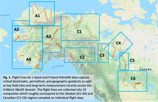
Figure 1. Flight lines for L-band and P-band PolInSAR measurements capture critical bioclimatic, permafrost, and geographic gradients as well as key field sites and long-term measurement records across the ABoVE domain. The flight lines are collected into 10 composites which roughly correspond to the Alaskan (A1-A4) and Canadian (C1-C6) regions sampled on individual flight days. Basemap source: Google Maps.
Citation
Miller, C.E., P. Griffith, E.E. Hoy, N. Pinto, Y. Lou, S. Hensley, B. Chapman, J.L. Baltzer, K. Bakian-Dogaheh, W.R. Bolton, L.L. Bourgeau-Chavez, R.H. Chen, B-H. Choe, L.K. Clayton, T.A. Douglas, N.H.F. French, J.E. Holloway, G. Hong, L. Huang, G. Iwahana, L.K. Jenkins, J.S. Kimball, T.V. Loboda, M.C. Mack, P. Marsh, R.J. Michaelides, M. Moghaddam, A.D. Parsekian, K. Schaefer, P. Siqueira, D. Singh, A. Tabatabaeenejad, M.R. Turetsky, R. Touzi, E. Wig, P. Wilson, C.J. Wilson, S.D. Wullschleger, Y. Yi, H.A. Zebker, Y. Zhang, Y. Zhao, and S.J. Goetz. 2023. Summary of the ABoVE L-band and P-band Airborne SAR Surveys, 2012-2022. ORNL DAAC, Oak Ridge, Tennessee, USA. https://doi.org/10.3334/ORNLDAAC/2150
Table of Contents
- Dataset Overview
- Data Characteristics
- Application and Derivation
- Quality Assessment
- Data Acquisition, Materials, and Methods
- Data Access
- References
Dataset Overview
This dataset contains tables containing Airborne flight metadata from synthetic aperture radar (SAR) surveys from 2012 to 2022 in Alaska and Canada. NASA's Arctic Boreal Vulnerability Experiment (ABoVE) conducted airborne SAR surveys of over 120,000 km2 in Alaska and northwestern Canada during 2017, 2018, 2019, and 2022. Legacy lines acquired between 2012 and 2015 by other projects are included for completeness and to enable longer times series creation. The data files and companion file contain L-band and P-band airborne SAR metadata acquired during the ABoVE airborne campaigns. Included are detailed descriptions of ~80 SAR flight lines and how each fits into the ABoVE experimental design. Extensive maps, tables, and hyperlinks give direct access to every flight plan as well as individual flight lines. This entry is a guide to enable interested readers to fully explore the ABoVE L- and P-band SAR data.
Project: ABoVE
The Arctic-Boreal Vulnerability Experiment (ABoVE) is a NASA Terrestrial Ecology Program field campaign being conducted in Alaska and western Canada, for 8 to 10 years, starting in 2015. Research for ABoVE links field-based, process-level studies with geospatial data products derived from airborne and satellite sensors, providing a foundation for improving the analysis, and modeling capabilities needed to understand and predict ecosystem responses to, and societal implications of, climate change in the Arctic and Boreal regions.
Related Publication:
Miller, C. E., Griffith, P. C., Hoy, E., Pinto, N. S., Lou, Y., Hensley, S., Chapman, B. D., Baltzer, J., Bakian-Dogaheh, K., Bolton, W. R., Bourgeau-Chavez, L., Chen, R. H., Choe, B.-H., Clayton, L. K., Douglas, T. A., French, N., Holloway, J. E., Hong, G., Huang, L., Iwahana, G., Jenkins, L., Kimball, J. S., Loboda, T., Mack, M., Marsh, P., Michaelides, R. J., Moghaddam, M., Parsekian, A., Schaefer, K., Siqueira, P. R., Singh, D., Tabatabaeenejad, A., Turetsky, M., Touzi, R., Wig, E., Wilson, C. J., Wilson, P., Wullschleger, S. D., Yi, Y., Zebker, H. A., Zhang, Y., Zhao, Y., and Goetz, S. J.: The ABoVE L-band and P-band airborne synthetic aperture radar surveys, Earth Syst. Sci. Data, 16, 2605–2624, https://doi.org/10.5194/essd-16-2605-2024, 2024.
Related Datasets:
Related data are available on the ABoVE Project page.
Acknowledgements:
The L- and P-band SAR data acquisitions would not have been possible without the indefatigable support of our NASA pilots and flight crews. We thank John McGrath and the NASA AFRC C-20 (N30502) team as well as Derek Rutovic and the NASA JSC G-III (N995NA) team. We also thank the instrument scientists, operators, and data processing team from the JPL Suborbital Radar Science and Engineering Team (334F) who were essential to the successful execution of these experiments and rapid processing of the resulting data products. The field work supporting the SAR campaigns was made possible by the excellent support from Dan Hodkinson, Sarah Sackett, and the ABoVE Logistics Office. Finally, we thank the data curation team at the Oak Ridge National Laboratory Distributed Active Archive Center for their support and expert advice.
This work was supported by the NASA Terrestrial Ecology Program’s Arctic-Boreal Vulnerability Experiment (ABoVE). A portion of this work was performed at the Jet Propulsion Laboratory, California Institute of Technology, under contract with National Aeronautics and Space Administration (80NM0018D0004).
Data Characteristics
Spatial Coverage: Alaska, USA and Canada
Spatial Resolution: Locations throughout the ABoVE study domain
Temporal Coverage: 2012-01-01 to 2022-12-31
Temporal Resolution: Irregular flights throughout temporal coverage window
Study Areas: Latitude and longitude are given in decimal degrees.
| Site | Westernmost Longitude | Easternmost Longitude | Northernmost Latitude | Southernmost Latitude |
|---|---|---|---|---|
| Alaska and Canada | -169 | -102 | 72 | 50 |
Data File Information
This dataset includes 37 files in comma-separated values (*.csv) format and one file in Portable Document Format (*.pdf).
The file Summary_of_the_ABoVE_L-band_and_P-band_Airborne_SAR_Surveys.pdf contains L-band and P-band airborne SAR metadata acquired during the ABoVE airborne campaigns. Included are detailed descriptions of ~80 SAR flight lines and how each fits into the ABoVE experimental design. Extensive maps, tables, and hyperlinks give direct access to every flight plan as well as individual flight lines.
Each *.csv (e.g. Table_1_ABoVE_L-band_PolInSAR_Campaign_1.csv) coincides with a table in the PDF document. These files contain details regarding airborne SAR flights, including the flight plan number and a URL to flight plan summary at uavsar.jpl.nasa.gov.
Table 1. Data dictionary for CSV data files (Table_*.csv). Each file contains a subset of these fields.
| Variable | Units | Description |
|---|---|---|
| Flight_plan | Airborne flight plan number | |
| Flight_plan_url | URL to flight plan summary at uavsar.jpl.nasa.gov | |
| Sortie_date | YYYY-MM-DD | Flight date |
| Region_sampled | Region sampled | |
| Region_sampled_url | URL to flight plan map at uavsar.jpl.nasa.gov | |
| PoIInSAR_band | SAR band; L or P-band | |
| Campaign | Name of airborne campaign | |
| Line_ID | Flight line ID | |
| Short_name | Flight line name | |
| Flight | Airborne flight plan number. Synonymous to ‘Flight_plan’ | |
| Flight_url | URL to flight plan summary at uavsar.jpl.nasa.gov. Synonymous to ‘Flight_plan_url’. | |
| Band | SAR band; L or P-band | |
| Date | YYYY-MM-DD | Flight date. Synonymous to ‘Sortie_date’. |
| Region | Region sampled. Synonymous to ‘Region_sampled’ | |
| Comments | Contains additional details about the flight line |
Application and Derivation
These files enable interested readers to fully explore the ABoVE L- and P-band synthetic aperture radar (SAR) data. See Miller et al. (2019) for an overview of the ABoVE airborne campaign and discussion of the L-band and P-band SAR within the context of the ABoVE project.
Quality Assessment
None provided.
Data Acquisition, Materials, and Methods
Please refer to the documentation file, Summary_of_the_ABoVE_L-band_and_P-band_Airborne_SAR_Surveys.pdf, for methodology details.
Data Access
These data are available through the Oak Ridge National Laboratory (ORNL) Distributed Active Archive Center (DAAC).
Summary of the ABoVE L-band and P-band Airborne SAR Surveys, 2012-2022
Contact for Data Center Access Information:
- E-mail: uso@daac.ornl.gov
- Telephone: +1 (865) 241-3952
References
Miller, C.E., P.C. Griffith, S.J. Goetz, E.E. Hoy, N. Pinto, I.B. McCubbin, A.K. Thorpe, M. Hofton, D. Hodkinson, C. Hansen, J. Woods, E. Larson, E.S. Kasischke, and H.A. Margolis. 2019. An overview of ABoVE airborne campaign data acquisitions and science opportunities. Environmental Research Letters 14:080201. https://doi.org/10.1088/1748-9326/ab0d44
Miller, C. E., Griffith, P. C., Hoy, E., Pinto, N. S., Lou, Y., Hensley, S., Chapman, B. D., Baltzer, J., Bakian-Dogaheh, K., Bolton, W. R., Bourgeau-Chavez, L., Chen, R. H., Choe, B.-H., Clayton, L. K., Douglas, T. A., French, N., Holloway, J. E., Hong, G., Huang, L., Iwahana, G., Jenkins, L., Kimball, J. S., Loboda, T., Mack, M., Marsh, P., Michaelides, R. J., Moghaddam, M., Parsekian, A., Schaefer, K., Siqueira, P. R., Singh, D., Tabatabaeenejad, A., Turetsky, M., Touzi, R., Wig, E., Wilson, C. J., Wilson, P., Wullschleger, S. D., Yi, Y., Zebker, H. A., Zhang, Y., Zhao, Y., and Goetz, S. J.: The ABoVE L-band and P-band airborne synthetic aperture radar surveys, Earth Syst. Sci. Data, 16, 2605–2624, https://doi.org/10.5194/essd-16-2605-2024, 2024.