Documentation Revision Date: 2018-09-17
Data Set Version: 1
Summary
The 2017 AAC was one of the largest, most complex airborne science experiments conducted by NASA's Earth Science Division. Between April and November 2017, the AAC involved ten aircraft in more than 200 science flights that surveyed over 4 million km2 in Alaska and northwestern Canada. Many flights were coordinated with same-day ground-based measurements to link process-level studies with geospatial data products derived from satellite sensors. The AAC collected data spanning the critical intermediate space and time scales that are essential for a comprehensive understanding of scaling across the ABoVE Study Domain and ultimately extrapolation to the pan-Arctic using satellite data and ecosystem models. The AAC provided unique opportunities to validate satellite and airborne remote sensing data and data products for northern high latitude ecosystems. The science strategy coupled domain-wide sampling with L-band and P-band synthetic aperture radar (SAR), imaging spectroscopy, full waveform LIDAR, atmospheric trace gases (including carbon dioxide and methane), as well as focused studies using Ka-band SAR and solar-induced chlorophyll fluorescence.
Targets of interest included field sites operated by the ABoVE Science Team as well as intensive sites operated by the DOE NGEE-Arctic team on the Seward Peninsula and in Barrow, NSF-LTER sites at Toolik Lake (Arctic/North Slope) and Bonanza Creek (Boreal/Interior Alaska), the Canadian Cold Regions Hydrology sites in the Arctic tundra near Trail Valley Creek NT, the interdisciplinary science stations at Daring Lake NT and Scotty Creek NT, the Government of the Northwest Territories Slave River/Slave Delta watershed time series, the Kluane Lake (YT) Research Station, and numerous forest and fire disturbance plots maintained by the National Park Service, and the US and Canadian Forest Services.
There are four files in this dataset: three compressed shapefiles (.zip) and one comma-separated text file (.csv).
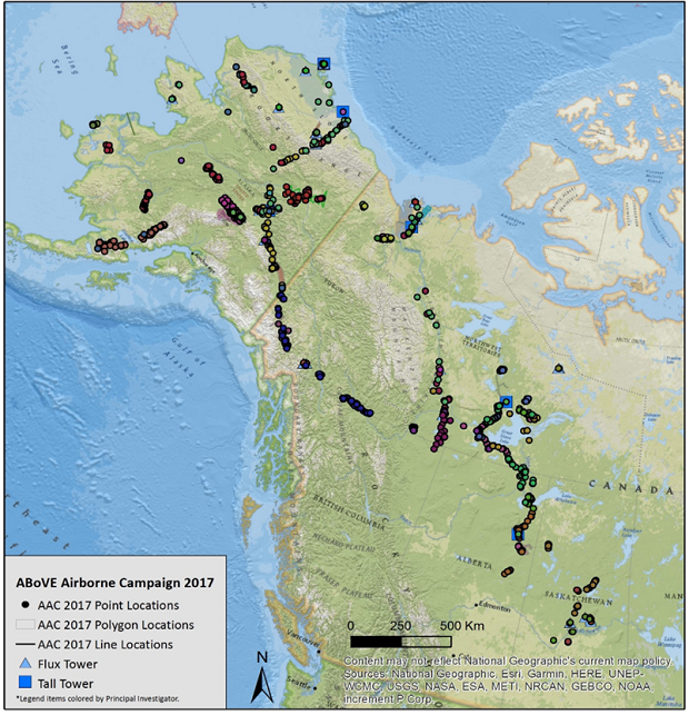
Figure 1. Locations of the field sites (points, lines, and polygons) used in planning the 2017 ABoVE Airborne Campaign.
Citation
Hoy, E.E., P. Griffith, C.E. Miller, and ABoVE Science Team. 2018. ABoVE: Directory of Field Sites Associated with 2017 ABoVE Airborne Campaign. ORNL DAAC, Oak Ridge, Tennessee, USA. https://doi.org/10.3334/ORNLDAAC/1582
Table of Contents
- Data Set Overview
- Data Characteristics
- Application and Derivation
- Quality Assessment
- Data Acquisition, Materials, and Methods
- Data Access
- References
- Data Set Revisions
Data Set Overview
This dataset provides a listing of the ~6,700 field sites used in planning the ABoVE Airborne Campaign (AAC) for 2017. The sites included point, polygon, and line locations that were used in determining the 2017 AAC flight paths. We intend this compilation to assist investigators in understanding the flight line choices and as a method for investigators to identify ground locations used in the airborne campaign. Data users may also search for the underlying data available at each of these locations. Site descriptors include name, coordinates, principal investigators with emails, data types, long-term archive locations, and links to project descriptions.
The 2017 AAC was one of the largest, most complex airborne science experiments conducted by NASA's Earth Science Division. Between April and November 2017, the AAC involved ten aircraft in more than 200 science flights that surveyed over 4 million km2 in Alaska and northwestern Canada. Many flights were coordinated with same-day ground-based measurements to link process-level studies with geospatial data products derived from satellite sensors. The AAC collected data spanning the critical intermediate space and time scales that are essential for a comprehensive understanding of scaling across the ABoVE Study Domain and ultimately extrapolation to the pan-Arctic using satellite data and ecosystem models. The AAC provided unique opportunities to validate satellite and airborne remote sensing data and data products for northern high latitude ecosystems. The science strategy coupled domain-wide sampling with L-band and P-band synthetic aperture radar (SAR), imaging spectroscopy, full waveform LIDAR, atmospheric trace gases (including carbon dioxide and methane), as well as focused studies using Ka-band SAR and solar-induced chlorophyll fluorescence.
Targets of interest included field sites operated by the ABoVE Science Team as well as intensive sites operated by the DOE NGEE-Arctic team on the Seward Peninsula and in Barrow, NSF-LTER sites at Toolik Lake (Arctic/North Slope) and Bonanza Creek (Boreal/Interior Alaska), the Canadian Cold Regions Hydrology sites in the Arctic tundra near Trail Valley Creek NT, the interdisciplinary science stations at Daring Lake NT and Scotty Creek NT, the Government of the Northwest Territories Slave River/Slave Delta watershed time series, the Kluane Lake (YT) Research Station, and numerous forest and fire disturbance plots maintained by the National Park Service, and the US and Canadian Forest Services.
Project: Arctic-Boreal Vulnerability Experiment
The Arctic-Boreal Vulnerability Experiment (ABoVE) is a NASA Terrestrial Ecology Program field campaign based in Alaska and western Canada between 2016 and 2021. Research for ABoVE links field-based, process-level studies with geospatial data products derived from airborne and satellite sensors, providing a foundation for improving the analysis and modeling capabilities needed to understand and predict ecosystem responses and societal implications.
Acknowledgements:
This study was funded by NASA's Arctic-Boreal Vulnerability Experiment.
Data Characteristics
Spatial Coverage: ABoVE core domain in Alaska and Canada
Spatial resolution: NA
Temporal coverage: Nominal date of 2017-04-01
Temporal resolution: NA
Study Areas (All latitude and longitude given in decimal degrees)
| Site | Westernmost Longitude | Easternmost Longitude | Northernmost Latitude | Southernmost Latitude |
|---|---|---|---|---|
| Alaska and Canada | -166.007823 | -103.596211 | 71.328014 | 52.71167 |
Data File Information
There are four files in this dataset. This includes one comma-separated file (.csv) and three compressed files (.zip) which contain shapefiles (.shp).
Table 1. Data file names and descriptions
| File name | Description |
|---|---|
| above_airborne_campaign_point_locations.csv | This file provides descriptors for the ~6,700 submitted field sites with point locations in comma separated format. Content as shown in Table 2. |
| above_airborne_campaign_point_locations.zip | This file provides descriptors for the ~6,700 submitted field sites with point locations as a shapefile. All content as shown in Table 2. |
| above_airborne_campaign_polygon_locations.zip | This file provides descriptors for the 15 submitted field sites with polygon locations as a shapefile. This file contains the information from columns 1, 2, 5-9, 12 and 15 in Table 2. |
| above_airborne_campaign_line_locations.zip | This file provides descriptors for the 7 submitted field sites with line locations as a shapefile. This file contains the information from columns 1, 2, 5-9, 12 and 15 in Table 2. |
| above_airborne_campaign_all_locations.kmz | A companion file provided for viewing in Google Earth-contains all locations. Point, polygon, and line locations can be viewed separately. |
Table 2. Data file content
User Notes:
- Not applicable or missing character values are coded as "N/A". There are no missing numeric values.
- Some information provided in the files is very likely to change over time and may have changed before publication, including investigator emails, archive locations, data links, and project description links. There are no plans to keep this information up to date.
- Some of the categorical fields have not been edited for consistency, including name, region, data type, archive, and tower type. Users trying to search for a particular site or data type may need to use multiple search strategies. Start with latitude and longitude or the *.kmz companion file in Google Earth.
| Column # | Variable | Summary |
|---|---|---|
| 1 | name | Plot, site, or location identifier |
| 2 | region | General location of the plot, site, or location. |
| 3 | point_y | Latitude |
| 4 | point_x | Longitude |
| 5 | data_type | General description of the type of data set available for the plot, site, or location. |
| 6 | PI | Principal Investigator (PI) associated with the plot, site or location. |
| 3 | PI_email | Principal Investigator (PI) email address associated with the PI. |
| 8 | archive | Long-term archive location for the full data set available for the plot, site, or location. |
| 9 | data_link1 | Web address 1 for the long-term archive location of the full data set available for the plot, site, or location. |
| 10 | data_link2 | Web address 2 for the long-term archive location of the full data set available for the plot, site, or location. |
| 11 | tower_type | Tall towers and flux towers used in the planning of the ABoVE Airborne Campaign. This field is used as a quick indication of the tower type for a particular site. |
| 12 | prj_profile1 | Project Profile 1 – A web link provided to the ABoVE project profile where more information about the data can be found. |
| 13 | prj_profile2 | Project Profile 2 – A web link provided to the ABoVE project profile where more information about the data can be found. |
| 4 | prj_profile3 | Project Profile 3 – A web link provided to the ABoVE project profile where more information about the data can be found. |
| 15 | layer_name | Original file name of the file provided by the investigator during the AAC planning process. |
| 16 | PI_v2 | The Principal Investigator’s name displayed without special characters. |
Note: point_y, point_x, and PI_v2 are used only in the csv point location file, the point shapefile, and the point kmz file.
Projection Information of the shapefiles:
PROJCS: Canada_Albers_Equal_Area_Conic
GEOGCS: GCS North American 1983, DATUM North American 1983
SPHEROID: GRS 1980, 6378137.0,298.257222101
PRIMEM: Greenwich,0.0
UNIT: Degree: 0.0174532925199433
PROJECTION: Albers_Conic_Equal_Area
False Easting: 0.0, False Northing: 0.0, longitude of center: -96.0, latitude of center: 40.0
UNIT: Meter- 1.0
Application and Derivation
The AAC collected data spanning the critical intermediate space and time scales that are essential for a comprehensive understanding of scaling across the ABoVE Study Domain and ultimately extrapolation to the pan-Arctic using satellite data and ecosystem models. The information provided in these files provides information to serve as a project reference for information pertaining to the ABoVE Airborne Campaign 2017 flights.
Quality Assessment
It should be noted that certain information provided in the files could change such as investigator emails, etc. The ORNL DAAC will not provide future updates to the files.
Data Acquisition, Materials, and Methods
The AAC was one of the largest, most complex airborne science experiments conducted by NASA’s Earth Science Division. Ten aircraft flew in more than 200 science flights that conducted surveys across over 4 million km2 in Alaska and northwestern Canada between April and November. Many flights were coordinated with same-day ground-based measurements to link process-level studies with geospatial data products derived from satellite sensors. The AAC provided unique opportunities to validate satellite and airborne remote sensing data and data products for northern high latitude ecosystems (NASA ABoVE Airborne Science).
The information assembled for this dataset serves as an information resource regarding research projects, coordinates of study areas, and Principal Investigators for the AAC 2017 flights.
Data Access
These data are available through the Oak Ridge National Laboratory (ORNL) Distributed Active Archive Center (DAAC).
ABoVE: Directory of Field Sites Associated with 2017 ABoVE Airborne Campaign
Contact for Data Center Access Information:
- E-mail: uso@daac.ornl.gov
- Telephone: +1 (865) 241-3952
References
Data Set Revisions