Documentation Revision Date: 2019-04-25
Dataset Version: 1
Summary
The data products were produced using a time-series retrieval algorithm approach applied to the AirMOSS P-band polarimetric synthetic aperture radar (PolSAR) data. The retrieval process is an inversion of a forward radar backscattering model, where a three-layer dielectric structure is used to model the active layer (surface and subsurface layers) and the underlying permafrost. Multiple retrieval runs were performed for each pixel during the inversion process, from which the mean and standard deviation are reported as the retrieved value and associated uncertainty for the desired geophysical parameters. Soil dielectric constants (representing soil with unfrozen water content), soil layer depths, and surface roughness were retrieved.
There are 29 data files with this dataset in NetCDF (.nc4) format. Not all sites were surveyed each year.

Figure 1. Active layer thickness with uncertainty and surface roughness with uncertainty for the Deadhorse flight line over the northern section of Dalton Highway in 2015. Images from Chen et al. (2019).
Citation
Chen, R.H., A. Tabatabaeenejad, and M. Moghaddam. 2019. ABoVE: Active Layer and Soil Moisture Properties from AirMOSS P-band SAR in Alaska. ORNL DAAC, Oak Ridge, Tennessee, USA. https://doi.org/10.3334/ORNLDAAC/1657
Table of Contents
- Dataset Overview
- Data Characteristics
- Application and Derivation
- Quality Assessment
- Data Acquisition, Materials, and Methods
- Data Access
- References
Dataset Overview
This dataset provides estimates of soil geophysical properties derived from Airborne Microwave Observatory of Subcanopy and Subsurface (AirMOSS) P-band polarimetric synthetic aperture radar (PolSAR) data collected in August and October of 2014, 2015, and 2017 over 12 study sites (with some exceptions) across Northern Alaska. Soil properties reported include the active layer thickness (ALT), dielectric constant, soil moisture profile, surface roughness, and their respective uncertainty estimates at 30-m spatial resolution over the 12 flight transects. Most of the study sites are located within the continuous permafrost zone and where the aboveground vegetation consisting mainly of dwarf shrub and tussock/sedge/moss tundra has a minimal impact on P-band radar backscatter.
The data products were produced using a time-series retrieval algorithm approach applied to the AirMOSS P-band polarimetric synthetic aperture radar (PolSAR) data (Chen et al., 2019). The retrieval process is an inversion of a forward radar backscattering model, where a three-layer dielectric structure is used to model the active layer (surface and subsurface layers) and the underlying permafrost. Multiple retrieval runs were performed for each pixel during the inversion process, from which the mean and standard deviation are reported as the retrieved value and associated uncertainty for the desired geophysical parameters. Soil dielectric constants (representing soil with unfrozen water content), soil layer depths, and surface roughness were retrieved.
Project: Arctic-Boreal Vulnerability Experiment
The Arctic-Boreal Vulnerability Experiment (ABoVE) is a NASA Terrestrial Ecology Program field campaign based in Alaska and western Canada between 2016 and 2021. Research for ABoVE links field-based, process-level studies with geospatial data products derived from airborne and satellite sensors, providing a foundation for improving the analysis and modeling capabilities needed to understand and predict ecosystem responses and societal implications.
Related Project: Airborne Microwave Observatory of Subcanopy and Subsurface (AirMOSS)
Related Publication:
Chen, R. H., A. Tabatabaeenejad, and M. Moghaddam. 2019. Retrieval of Permafrost active layer properties using time-series P-band radar observations. IEEE Transactions on Geoscience and Remote Sensing. In press.
Related Dataset:
Moghaddam, M. et al. 2019. L1 S-0 Polarimetric Data from AirMOSS P-band SAR, Alaska, 2014-2015. ORNL DAAC, Oak Ridge, Tennessee, USA.
Acknowledgments
This research received funding from the NASA Arctic Boreal and Vulnerability Experiment (ABoVE), grant number NNX17AC65A, and from NASA's interdisciplinary science program, grant number NNX14AO23G.
Data Characteristics
Spatial Coverage: 12 study sites across Northern Alaska: Ambler, Atqasuk, Barrow, Coldfoot, Council, Deadhorse, Huslia, Ivotuk, Kougarok, Koyuk, Teller, and Toolik.
ABoVE Reference Locations:
Domain: Core ABoVE
State/territory: Alaska
Grid cells:
Ah0v0Bh3Bv2Ch0Cv0, Ah0v0Bh4Bv2Ch0Cv0, Ah0v0Bh5Bv2Ch0Cv0, Ah0v0Bh4Bv1Ch0Cv0, Ah0v0Bh3Bv1Ch0Cv0, Ah0v0Bh4Bv3Ch0Cv0, Ah0v0Bh5Bv3Ch0Cv0, Ah1v0Bh6Bv2Ch0Cv0, Ah1v0Bh7Bv2Ch0Cv0, Ah1v0Bh8Bv2Ch0Cv0, Ah1v0Bh9Bv2Ch0Cv0, Ah1v0Bh7Bv1Ch0Cv0, Ah1v0Bh8Bv1Ch0Cv0, Ah1v0Bh7Bv3Ch0Cv0, Ah1v0Bh8Bv3Ch0Cv0, Ah1v0Bh6Bv4Ch0Cv0, Ah1v0Bh7Bv4Ch0Cv0
Spatial resolution: 30 m
Temporal coverage: 2014-10-09 to 2017-08-17
Study Areas: All latitude and longitude given in decimal degrees.
| Site | Westernmost Longitude | Easternmost Longitude | Northernmost Latitude | Southernmost Latitude |
|---|---|---|---|---|
| Northern Alaska | -167.9442 | -150.2485 | 70.8774 | 64.7127 |
Table 1. Study Site Summary. Coordinates represent the approximate boundaries of all flights over the site. See Figure 2 for a map.
| Study Site (Region) | Site Abbreviation | Sampled in 2014 | Sampled in 2015 | Sampled in 2017 | North Latitude | South Latitude | East Longitude | West Longitude |
|---|---|---|---|---|---|---|---|---|
| Ambler (Brooks Range Foothills, south) | ambler | X | X | X | 66.7 | 66.4 | -161 | -161.6 |
| Atqasuk (North Slope) | atqasu | X | X | X | 70.3 | 70 | -159.8 | -160.4 |
| Barrow (North Slope) | barrow | X | X | X | 70.9 | 70.6 | -158.2 | -158.9 |
| Coldfoot (Brooks Range Foothills, south) | coldfo | - | X | X | 66.9 | 66.7 | -152.8 | -153.4 |
| Council (Seward Peninsula) | council/seward | X | X | - | 65 | 64.8 | -166.2 | -166.7 |
| Deadhorse (North Slope) | dhorse | X | X | X | 69.8 | 69.5 | -151 | -151.6 |
| Huslia (Interior Alaska) | huslia | - | X | X | 65.6 | 65.4 | -156.7 | -157.2 |
| Ivotuk (Brooks Range Foothills, north) | ivotuk | X | X | X | 68.5 | 68.2 | -157.9 | -158.5 |
| Kougarok (Seward Peninsula) | kougar | X | X | X | 65.7 | 65.4 | -163.7 | -164.2 |
| Koyuk (Interior Alaska) | koyukk | X | X | X | 65.1 | 64.8 | -162.4 | -162.9 |
| Teller (Seward Peninsula) | seward | - | - | X | 65 | 64.7 | -167.5 | -167.9 |
| Toolik (North Slope) | toolik | - | - | X | 68.9 | 68.6 | -150.2 | -150.9 |
Data File Information
There are 29 data files with this dataset in NetCDF (.nc4) format; one file per year per site. Note, as indicated in Table 1, not all sites were flown each year.
The data files provide estimates of the soil active layer properties including soil dielectric constant and moisture profiles, active layer thickness (ALT), surface roughness, and respective uncertainties.
File Naming Convention:
PolSAR_active_layer_prop_site_YYMMDD_YYMMDD_VV.nc4
where:
site: Six letter abbreviation of the 12 sites where data were acquired. See Table 1 above.
YYMMDD_YYMMDD: Date (UTC) at the start of a data take, with YY being the last two digits of the year, MM the month of the year (01-12), and DD the day of the month (01-31). There were two PolSAR data takes over the same site used in each file, thus the two dates, August and October, in each file name.
VV: product version number.
Example file name: PolSAR_active_layer_prop_ambler_140816_141009_01.nc4
Spatial Reference Properties:
Coordinate System: Canada_Albers_Equal_Area_Conic
EPSG: 102001
Data Dictionary
Table 2. Variables in the data files. Fill value is -9999.
| Variable | Units | Description |
|---|---|---|
| X | m | X coordinate of projection |
| Y | m | Y coordinate of projection |
| alt | m | Active layer thickness (ALT) |
| epsilon1_aug | Surface soil dielectric constant at August snapshot | |
| epsilon1_oct | Surface soil dielectric constant at October snapshot | |
| epsilon2 | Subsurface soil dielectric constant | |
| mv1_aug | vol/vol | Surface soil moisture at August snapshot |
| mv1_oct | vol/vol | Surface soil moisture at October snapshot |
| mv2 | vol/vol | Subsurface soil moisture |
| z1_aug | m | Surface layer depth at August snapshot |
| z1_oct | m | Surface layer depth at October snapshot |
| h | m | Surface roughness |
| lat | degrees | Latitude-degrees north |
| lon | degrees | Longitude-degrees east |
| alt_uncertainty | m | Uncertainty of ALT estimates |
| epsilon1_aug_uncertainty | Uncertainty of epsilon1_aug estimates | |
| epsilon1_oct_uncertainty | Uncertainty of epsilon1_oct estimates | |
| epsilon2_uncertainty | Uncertainty of epsilon2 estimates | |
| mv1_aug_uncertainty | vol/vol | Uncertainty of mv1_aug estimates |
| mv1_oct_uncertainty | vol/vol | Uncertainty of mv1_oct estimates |
| mv2_uncertainty | vol/vol | Uncertainty of mv2 estimates |
| z1_aug_uncertainty | m | Uncertainty of z1_aug estimates |
| z1_oct_uncertainty | m | Uncertainty of z1_oct estimates |
| h_uncertainty | m | Uncertainty of h estimates |
Application and Derivation
Soil moisture profiles and ALT are key variables in understanding the permafrost active layer dynamics that respond to the summer climate and land surface conditions. The provided active layer product estimates capture the effects of soil, topography, and vegetation heterogeneity within each radar transect at the regional scale.
Quality Assessment
Multiple retrieval runs were performed for each pixel during the inversion process, from which the mean and standard deviation are reported as the retrieved value and associated uncertainty for the desired geophysical parameters.
The retrieved ALT was validated against manual probing measurements taken at the Circumpolar Active Layer Monitoring (CALM) sites within the radar swaths. Results from the Chen et al. (2019) study show that the retrieved ALT values are generally underestimated for the sites where the in-situ ALT is larger than the P-band sensing depth, with a retrieval bias ranging from -0.05 m to -0.24 m as validated against the in-situ ALT measurements collected at CALM sites. For the sites where the in-situ ALT is smaller than 0.55 m, the retrieval errors are generally less than 0.1 m (Chen et al., 2019).
Data Acquisition, Materials, and Methods
The study areas are focused on the flight lines across Northern Alaska (Fig. 2). Most of the sites are located within the continuous permafrost zone and the aboveground vegetation consisting mainly of dwarf shrub and tussock/sedge/moss tundra has minimal impact on P-band radar backscatter and can be ignored, as indicated by the simulations using the scattering model.
To determine the pixels on which the retrieval algorithm will be performed, the land cover information from the National Land Cover Database (NLCD) for the state of Alaska from the year 2011 is used. The pixels classified as open water or developed areas, or forest pixels were excluded.
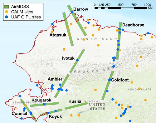
Figure 2. AirMOSS radar swaths and permafrost observation sites over Northern Alaska. Note that the 2017 flights over Toolik Lake (North Slope) and Teller (Seward Peninsula) are not displayed. CALM sites: Circumpolar Active Layer Monitoring program site manual probing measurements were used to validate the retrieved ALT data. UAF GIPL sites: Geophysical Institute Permafrost Laboratory (GIPL), University of Alaska Fairbanks (UAF) site in-situ soil moisture and temperature profiles were used to delineate the three-layer dielectric structure model representing the active layer soils and underlying permafrost. From Chen et al. (2019).
Mid-late August and early October flights were selected for the time-series to capture the maximum thaw and partially frozen seasons, when the boundary location between thawed active layer and permafrost is still observable and can be assumed constant over the time window. The dielectric constant of the lower part of the active layer is also assumed to be constant because the unfrozen water content depends only on soil porosity within the saturated zone.
Retrieval of Active Layer Properties
The retrieval of active layer properties was performed using a two-element time-series of measurements, one taken in mid-late August and one taken in early October.
The retrieval process is an inversion of a forward radar backscattering model, where a three-layer dielectric structure was assumed based on the observations made from the in-situ data and is used to model the active layer (surface and subsurface layers) and the underlying permafrost. Soil dielectric constants (representing soil with unfrozen water content), soil layer depths, and surface roughness are retrieved. The values of volumetric soil moisture are translated from the soil dielectric constants using the calibration equation by Engstrom et al. (2005).
Multiple retrieval runs were performed for each pixel during the inversion process, from which the mean and standard deviation are reported as the retrieved value and associated uncertainty for the desired geophysical parameters.
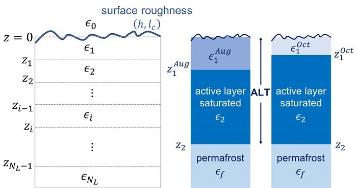
Figure 3. Diagram of a three-layer dielectric structure used to model the active layer (surface and subsurface layers). Image is from Chen et al. (2019).
For additional details, refer to Chen et al. (2019).
Data Access
These data are available through the Oak Ridge National Laboratory (ORNL) Distributed Active Archive Center (DAAC).
ABoVE: Active Layer and Soil Moisture Properties from AirMOSS P-band SAR in Alaska
Contact for Data Center Access Information:
- E-mail: uso@daac.ornl.gov
- Telephone: +1 (865) 241-3952
References
Chen, R.H., A. Tabatabaeenejad, and M. Moghaddam. 2019. Retrieval of permafrost active layer properties using time-series P-band radar observations. IEEE Transactions on Geoscience and Remote Sensing.
Engstrom, R., A. Hope, H. Kwon, D. Stow, and D. Zamolodchikov. 2005. Spatial distribution of near surface soil moisture and its relationship to microtopography in the Alaskan Arctic coastal plain. Hydrology Research, vol. 36, no. 3, pp. 219-234. https://doi.org/10.2166/nh.2005.0016