Documentation Revision Date: 2021-12-21
Dataset Version: 1
Summary
There are 68,615 data files in HDF-EOS (*.hdf) format included in this dataset.
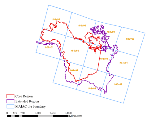
Figure 1. MAIAC tiles (blue squares with yellow labels) and ABoVE core (red) and extended (purple) domain boundaries covering Alaska and western Canada. Source: adapted from Yu et al. 2021
Citation
Yu, R., G. Hmimina, K.F. Huemmrich, D.P. Billesbach, A. Lyapustin, Y. Wang, Z. Jingchao, R. Wang, and J.A. Gamon. 2021. ABoVE: Angular-corrected MODIS MAIAC Reflectance across Alaska and Canada, 2000-2017. ORNL DAAC, Oak Ridge, Tennessee, USA. https://doi.org/10.3334/ORNLDAAC/1858
Table of Contents
- Dataset Overview
- Data Characteristics
- Application and Derivation
- Quality Assessment
- Data Acquisition, Materials, and Methods
- Data Access
- References
Dataset Overview
This dataset provides angular corrections of MODIS Multi-Angle Implementation of Atmospheric Correction algorithm (MAIAC) surface reflectances across the ABoVE domain in Alaska and western Canada from 2000 to 2017. Using random forests (RF), a machine-learning approach, the original MAIAC reflectance data were corrected to consistent view and illumination angles (0-degree view zenith angle and 45-degree sun zenith angle) to reduce artifacts and variability due to angular effects. The original MAIAC data's sub-daily temporal resolution and 1 km spatial resolution with seven land bands (bands 1–7) and five ocean bands (bands 8–12) were preserved. The resulting surface reflectance data are suitable for long-term studies on patterns, processes, and dynamics of surface phenomena. The data cover 11 different Terra and Aqua satellite MODIS MAIAC tiles.
Project: Arctic-Boreal Vulnerability Experiment
The Arctic-Boreal Vulnerability Experiment (ABoVE) is a NASA Terrestrial Ecology Program field campaign being conducted in Alaska and western Canada, for 8 to 10 years, starting in 2015. Research for ABoVE links field-based, process-level studies with geospatial data products derived from airborne and satellite sensors, providing a foundation for improving the analysis, and modeling capabilities needed to understand and predict ecosystem responses to, and societal implications of, climate change in the Arctic and Boreal regions.
Related Publication
Yu, R., G. Hmimina, A. Lyapustin, Y. Wang, K. F. Huemmrich, D. Billesbach, J. Zhang, Z. Xu, and J. A. Gamon. 2021. Reducing angular effects in high-latitude MODIS MAIAC reflectance using random forests. This unpublished manuscript is available from rong.j.yu@gmail.com.
Related Datasets
Yu, R., G. Hmimina, K.F. Huemmrich, D.P. Billesbach, A. Lyapustin, Y. Wang, and J.A. Gamon. 2019. ABoVE: Corrected MODIS MAIAC Reflectance at Tower Sites, Alaska and Canada, 2000-2016. ORNL DAAC, Oak Ridge, Tennessee, USA. https://doi.org/10.3334/ORNLDAAC/1700
- This site-level product was compared to the current dataset's tile-level products.
Acknowledgments
This work was supported by NASA's ABoVE Program (grant NNX15AT78A).
Data Characteristics
Spatial Coverage: Alaska and western Canada
ABoVE Reference Locations
Domain: Core and Extended regions
State/Territory: Alaska, Canada
Grid cells: Ah000v000, Ah000v001, Ah001v000, Ah001v001, Ah001v002, Ah002v000, Ah002v001, Ah002v002, Ah003v000, Ah003v001, Ah003v002
User Note: The northwest tile (Ah00v00) extends from Alaska westward across the antemeridian (i.e., longitude 180/-180) to longitude 172.169.
Spatial Resolution: 1000 m
Temporal Coverage: 2000-02-24 to 2017-12-31
Temporal Resolution: Daily
Study Area: Latitude and longitude are given in decimal degrees.
| Site | Westernmost Longitude | Easternmost Longitude | Northernmost Latitude | Southernmost Latitude |
|---|---|---|---|---|
| Alaska and western Canada | 172.169 | -43.2944 | 80.8064 | 44.1164 |
Data File Information
There are 68,615 data files in HDF-EOS (*.hdf) format included in this dataset that include surface reflectance measurements and associated geospatial information.
The files are named GRFMAIACBRF.hHHvVV.YYYYDDD.hdf or MAIACLatLon.hHHvVV.hdf, where
HH and VV indicate the tile number, and
YYYYDDD is the year and day of the measurement.
Table 1. File names and descriptions.
| File Name | Number of Files | Description |
|---|---|---|
| GRFMAIACBRF.hHHvVV.YYYYDDD.hdf | 68,604 | Provide angular-corrected surface reflectance in 12 bands and fields for quality assurance (QA) status; both MODIS “land” bands (1–8) and “ocean” bands (9–12) are included |
| MAIACLatLon.hHHvVV.hdf | 11 | Provide the latitude and longitude for each 1200 x 1200 grid cell in the associated surface reflectance files |
Data File Details
Data are provided in a 1200 x 1200 grid, and each grid cell is 1 km x 1 km in size. The Coordinate Reference System is "GTCP_Albers" (+proj=aea +lat_1=49 +lat_2=77 +lat_0=49 +lon_0=-115 +datum=WGS84 +units=m +no_defs).
Table 2. Variable names and descriptions for the surface reflectance files.
| Variable | Bands | Data Type | Scale | Description |
|---|---|---|---|---|
| Surface reflectance * | 1–12 | INT16 | 0.0001 | Global random forest (GRF) corrected surface reflectance; the interval for valid values 0.0–1.0 |
| QA Status | 13 | UINT16 | 1.0 | Status flags encoded in bits (see Table 2) |
| NDSI and NDWI flag | 14 | UINT8 | 1.0 | Flags related to conditions of snow on surface and leaf water content (see Table 3) |
* Occasionally, angular corrections give extreme outliers. It is recommended that the interval [0.0,1.0] be applied as a filter on corrected reflectance values.
Table 3. Definition of quality assurance status codes stored in Band 13 as a 16-bit unsigned integer.
| Bits | Definition |
|---|---|
| 0–2 | Cloud Mask 000 = Undefined; 001 = Clear; 010 = Possibly Cloudy (detected by AOT filter); 011 = Cloudy (detected by cloud mask algorithm); 101 = Cloud Shadow; 110 = Hot spot of fire; 111 = Water Sediments |
| 3–4 | Land Water Snow/Ice Mask 00 = Land; 01 = Water; 10 = Snow; 11 = Ice |
| 5–7 | Adjacency Mask 000 = Normal condition; 001 = Adjacent to cloud; 010 = Surrounded by more than 8 cloudy pixels; 011 = Single cloudy pixel; 100 = Adjacent to snow; 101 = Snow was previously detected on this pixel |
| 8 | Aerosol Optical Thickness (AOT) Level 0 = AOT is low (<=0.6); 1 = AOT is high (> 0.6) or undefined |
| 9 | Algorithm Initialize Status 0 = Initialized; 1 = Not initialized |
| 10 | BRF Retrieved Over Snow (use AOT=0.05) 0 = no; 1 = yes |
| 11 | Altitude >3.5km (BRF is retrieved with AOT=0.01) 0 = no; 1 = yes |
Table 4. Flags pertaining to normalized difference snow index [NDSI=(band4-band6)/(band4+band6)] and normalized difference water index [vegetation water, NDWI=(band2-band5)/ band2+band5)]. The flag values identify the pixels with a reasonable range of values of ground snow index (NDSI) and/or plant water content index (NDWI). Flags are encoded as 8-bit unsigned integer values in Band 14.
| Values | Definition |
|---|---|
| 0 | No data |
| 1 | ( -1≤NDSI≤1 ) AND (-1≤NDWI≤1 ) |
| 2 | ( -1≤NDSI≤1 ) OR (-1≤NDWI≤1 ) |
| 3 | NDSI >-0.0452 (indicating potential snow) |
| 4 | no value of NDSI |
| 5 | no value of NDWI |
| 6 | no value of both NDSI and NDWI |
Application and Derivation
This dataset provides angular-corrected sub-daily surface reflectances in boreal and Arctic regions over the ABoVE domain. These corrected data reduce artifacts due to angular effects from instrument viewing angle and sunlight zenith angle. Corrected reflectances can provide more accurate measurements useful for a better understanding of long-term processes and dynamics of surface phenomena in high latitudes. They can help interpret or facilitate ground observations and can serve as an independent data source for detecting the vegetation responses to climatic conditions in this fast-changing region (Yu et al., 2021).
Quality Assessment
In the surface reflectance files, two quality assessment variables are provided in bands 13 and 14. Quality assurance flags were inherited from the original MAIAC dataset (Band 13; Table 2). A second flag was produced during the correction of the global random forest (GRF) model that describes the ground snow and plant leaf water content conditions (Band 14; Table 3). Occasionally, angular corrections to random forests (RF) give extreme outliers. It is recommended that the interval [0.0,1.0] be applied as a filter on corrected reflectance values.
Data Acquisition, Materials, and Methods
This angular correction dataset was based on the MODIS MAIAC land surface bidirectional reflectance factor (BRF) product (Lyapustin et al., 2018), which was obtained directly from the MAIAC team and used the same algorithm as the currently-available MCD19a1v006 product (Lyapustin and Wang, 2018). The MODIS MAIAC BRF product used the Albers projection (GCTP_Albers), which has the advantage in reducing distortion in high latitudes, while MCD19a1v006 used the sinusoidal projection.
The MODIS MAIAC BRF product improves the accuracy of cloud detection, aerosol retrievals, and atmosphere correction by integrating space and time in the image processing and provides additional MODIS ocean bands (8–12) (Lyapustin et al., 2018). By correcting for atmospheric effects, the BRF products provide enhanced estimates of ground-level reflectance. The BRDF (Bidirectional Reflectance Distribution Function) parameters in the original MAIAC data sometimes are missing or have a low quality during winter and seasonal transitions at high latitudes.
This dataset with newly derived angular correction factors seeks to improve estimates of surface reflectance. It was produced using a random forests (RF) approach to reduce solar-view geometry effects on satellite measurements. RF is a machine-learning technique used for classification and regression, and it was applied in this study to estimate angular correction factors. The RF analysis was conducted locally (on individual pixels) on a sample of 2683 randomly selected pixels. Then, a global random forest (GRF) model was derived from local pixel-level results and applied to all pixels across the 11 MODIS tiles. Using the derived correction factors, the MAIAC BRF reflectances were normalized to a 0 degree (nadir) instrument viewing angle with a 45-degree sun zenith angle.
Data Access
These data are available through the Oak Ridge National Laboratory (ORNL) Distributed Active Archive Center (DAAC).
ABoVE: Angular-corrected MODIS MAIAC Reflectance across Alaska and Canada, 2000-2017
Contact for Data Center Access Information:
- E-mail: uso@daac.ornl.gov
- Telephone: +1 (865) 241-3952
References
Lyapustin, A., and Y. Wang. 2018. MCD19A1 MODIS/Terra+Aqua Land Surface BRF Daily L2G Global 500m and 1km SIN Grid V006. NASA EOSDIS Land Processes DAAC. https://doi.org/10.5067/MODIS/MCD19A1.006
Lyapustin, A., Y. Wang, S. Korkin, and D. Huang. 2018. MODIS Collection 6 MAIAC algorithm. Atmospheric Measurement Techniques 11:5741–5765. https://doi.org/10.5194/amt-11-5741-2018
Yu, R., G. Hmimina, A. Lyapustin, Y. Wang, K. F. Huemmrich, D. Billesbach, J. Zhang, Z. Xu, and J. A. Gamon. 2021. Reducing angular effects in high-latitude MODIS MAIAC reflectance using random forests. This unpublished manuscript is available from rong.j.yu@gmail.com.