Documentation Revision Date: 2021-07-21
Dataset Version: 1
Summary
This dataset contains 90 data files in GeoTIFF (*.tif) format. Three files provide lichen coverage and volume across the full Fortymile study area and 87 provide site-level lichen cover or presence-absence estimates.
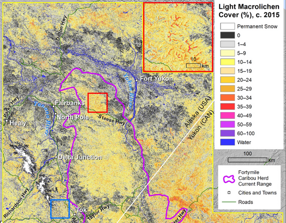
Figure 1. Fractional cover of light macrolichens estimated for 2015 across the northern extent of the 583,200 km2 Fortymile study area in eastern Alaska and Yukon. Source: Adapted from Macander et al., 2020
Citation
Macander, M., E.C. Palm, G.V. Frost, and P.R. Nelson. 2021. ABoVE: Lichen Forage Cover over Fortymile Caribou Range, Alaska and Yukon, 2000-2015. ORNL DAAC, Oak Ridge, Tennessee, USA. https://doi.org/10.3334/ORNLDAAC/1867
Table of Contents
- Dataset Overview
- Data Characteristics
- Application and Derivation
- Quality Assessment
- Data Acquisition, Materials, and Methods
- Data Access
- References
Dataset Overview
This dataset provides modeled estimates of lichen ground cover at 30 m resolution across the Fortymile study area in interior eastern Alaska, U.S., and the Yukon Territory, Canada, for the nominal year 2015. The mapped lichens are important winter forage for the nine resident caribou (Rangifer tarandus) herds in the region. A random forest modeling approach with vegetation inputs and environmental and spectral predictors was used to estimate lichen cover for 2015. Input data for the model were aggregated from historical in-situ vegetation plots, visual aerial surveys, and recent unmanned aerial system (UAS) imagery to align with 30 m resolution Landsat pixels over the 583,200 km2 study area. The model was also used to estimate lichen cover for the year 2000 by applying the trained model to historical Landsat imagery. An estimate of lichen volume in 2015, based on a published algorithm, is also provided. In addition, site-level presence-absence maps at <1 m resolution and site-level lichen cover maps at both 2 m and 30 resolution are provided. Site-level data were derived from high-resolution RGB imagery collected in summer 2017 from UASs at 22 forested and alpine sites across interior Alaska and western Yukon. Due to the use of two unique UAS imagers at 7 sites, there are 29 data collections across the 22 sites. Each UAS data collection is associated with three data files. These landscape-scale maps could be useful for understanding trends in lichen abundance and distribution, as well as for caribou research, management, and conservation.
Project: Arctic-Boreal Vulnerability Experiment
The Arctic-Boreal Vulnerability Experiment (ABoVE) is a NASA Terrestrial Ecology Program field campaign being conducted in Alaska and western Canada, for 8 to 10 years, starting in 2015. Research for ABoVE links field-based, process-level studies with geospatial data products derived from airborne and satellite sensors, providing a foundation for improving the analysis, and modeling capabilities needed to understand and predict ecosystem responses to, and societal implications of, climate change in the Arctic and Boreal regions.
Related Publication
Macander, M.J., E.C. Palm, G.V. Frost, J.D. Herriges, P.R. Nelson, C. Roland, K.L.M. Russell, M.J. Suitor, T.W. Bentzen, K. Joly, S.J. Goetz, and M. Hebblewhite. 2020. Lichen cover mapping for caribou ranges in interior Alaska and Yukon. Environmental Research Letters 15:055001. https:doi.org/10.1088/1748-9326/ab6d38
Acknowledgments
Funding was received from the Bureau of Land Management, Alaska Department of Fish and Game, National Park Service, Environment Yukon, and NASA's ABoVE (grants NNX15AW71A, NNX17AE44G, NNX15AU03A). Additional support was received from NASA’s Earth and Space Science Fellowship, Wildlife Conservation Society Canada’s W. Garfield Weston Fellowship, University of Montana’s W.A. Franke Graduate Fellowship, and Montana Institute on Ecosystems’ Graduate Research Award. The authors thank the dozens of botanists who collected ground and aerial vegetation data that were used to train and develop the lichen cover model.
Data Characteristics
Spatial Coverage: Alaska, U.S., and Yukon Territory, Canada
ABoVE Reference Locations
Domain: Core
State/Territory: Alaska and Yukon
Grid cells: Bh006v004, Bh007v004, Bh006v005, Bh007v005, Bh008v005, Bh006v006, Bh007v006, Bh008v006, Bh006v007, Bh007v007, Bh008v007, Bh009v007, Bh006v008, Bh007v008, Bh008v008, Bh009v008, Bh007v009, Bh008v009
Spatial Resolution: 30 m for study-area coverage; variable for site-level products (Table 1)
Temporal Coverage: Nominal years 2000 and 2015 for study area estimates; August 2017 for site data
Temporal Resolution: One-time annually for study area estimates; Single points for site data
Study Area: Latitude and longitude are given in decimal degrees.
Northernmost Latitude Southernmost Latitude Easternmost Longitude Westernmost Longitude
| Sites | Westernmost Longitude | Easternmost Longitude | Northernmost Latitude | Southernmost Latitude |
|---|---|---|---|---|
| 70.09064 | 58.61239 | -128.25554 | -153.85832 |
Data File Information
There are 90 data files in GeoTIFF (*.tif) format included in this dataset. The file naming convention for site-level files is Site_Date_FA_Platform_Date-Type_Resolution.tif (e.g., EASU27_20170607_70m_P3A_lichen_cover_02m.tif), where
- Site = Site code (Table 2)
- Date = UAS imaging date in YYYYMMDD
- FA = Flight altitude of UAS in meters ("3m", "46m", or "70m")
- Platform= Imager used (Phantom 3 Advanced ("P3A") or Phantom 4 Pro ("P4P"))
- Data-Type = "presence" or "lichen_cover"
- R = spatial resolution
Table 1. File names and descriptions.
| File Names | Resolution | Units | Description |
|---|---|---|---|
| Entire Study Area | |||
| 2000_macrolichen_cover_Fortymile_study_area.tif | 30 m | percent | 1 file; percent cover of lichen over the full range for the year 2000. |
| 2015_macrolichen_cover_Fortymile_study_area.tif | 30 m | percent | 1 file; percent cover of lichen over the full range for the year 2015. |
| 2015_lichen_volume_Fortymile_study_area.tif | 30 m | dm3 m-2 | 1 file; estimated lichen volume per pixel over the full range. Water coded as "200". |
| Site-level Files | |||
| Site_Date_FA_Platform_presence.tif | <1 m | 29 files; plot level presence (1) or absence (0) of lichen. | |
| Site_Date_FA_Platform_lichen_cover_R.tif | 2 m | percent | 29 files; plot level percent cover of lichen at 2 m resolution |
| Site_Date_FA_Platform_lichen_cover_R.tif | 30 m | percent | 29 files; plot level percent cover of lichen at 30 m resolution |
Data File Details
For each file,
- There is one band
- NoData values are coded as "255"
- The projection is Standard ABoVE, "Canada_Albers_Equal_Area_Conic," EPSG:102001.
Table 2. Site codes used in site-level file names. The 22 site codes are abbreviations derived from the names of local geographic features. User Note: A key to full site names is not available. The names are not required to use or understand the data. Latitude and longitude are given in decimal degrees.
| Site Code | Sample Date | Latitude | Longitude |
|---|---|---|---|
| BADO01 | 2017-08-01 | 63.84842778 | -137.5080917 |
| BLRI01 | 2017-07-30 | 64.59859722 | -138.3196111 |
| BLRI02 | 2017-07-30 | 64.60512778 | -138.3301889 |
| EASU27 | 2017-06-07 | 65.51098333 | -145.375425 |
| EASU32 | 2017-06-07 | 65.48817778 | -145.4120667 |
| EASU99 | 2017-06-07 | 65.49551389 | -145.3820194 |
| FACR11 | 2017-06-06 | 65.06966944 | -147.2734778 |
| FACR17 | 2017-06-04 | 65.08308056 | -147.3244083 |
| MD37 | 2017-06-01 | 64.95796667 | -148.3500722 |
| MD46 | 2017-05-31 | 64.96740556 | -148.3713278 |
| NOKL01 | 2017-07-31 | 64.47211111 | -138.1918778 |
| NOKL02 | 2017-07-31 | 64.43580556 | -138.2341417 |
| OMD41_17_1 | 2017-06-01 | 64.96266667 | -148.2225917 |
| TOWH01 | 2017-07-21 | 64.07572778 | -140.9604028 |
| TOWH02 | 2017-07-22 | 64.07057778 | -140.9552139 |
| TWSU20 | 2017-06-07 | 65.40775278 | -145.9511306 |
| TWSU21 | 2017-06-07 | 65.40140278 | -145.9762917 |
| TWSU22 | 2017-06-06 | 65.39768889 | -145.9674361 |
| WEHE01 | 2017-07-29 | 64.56963333 | -138.1439889 |
| WEHE02 | 2017-07-29 | 64.57357778 | -138.1450028 |
| WIPA01 | 2017-07-28 | 65.08397222 | -138.2776333 |
| WIPA02 | 2017-07-28 | 65.08588889 | -138.2686528 |
Application and Derivation
Terrestrial lichen cover is an important factor influencing herbivory and community interactions in northern boreal forests across seasons. Specifically, these lichen cover maps can be used to evaluate the influence of estimated lichen cover on caribou resource selection in the Fortymile herd (Macander et al., 2020). The landscape-scale maps could be useful for understanding trends in lichen abundance and distribution, as well as for caribou research, management, and conservation.
The use of high-resolution UAS imagery helps bridge the gap between fine-scale in-situ sampling and satellite imagery, demonstrating a relatively inexpensive and efficient way to collect data on vegetation cover with relevance to wildlife management. Imagery from UASs provided data to calibrate and validate regional lichen cover models over large spatial extents and provided a baseline for tracking lichen cover overtime at field sites.
Mapping of lichen cover distribution across several caribou ranges in central Alaska and Yukon provides a useful baseline for future efforts estimating lichen cover change over time. Change analyses would be potentially valuable for exploring longer-term population dynamics of caribou relative to their resource selection and nominal range distributions, as well as for assessing the effectiveness of caribou management actions and the potential impacts of climate change.
Quality Assessment
Multiple approaches were used to characterize the performance and uncertainty of the model results and are described in detail in Macander et al., 2020.
Overall, the lichen cover model was validated using reserved training data and existing external datasets. It was found that reserved data from aerial survey polygons (R2=0.77) and UAV imagery (R2=0.71) provided the best fit.
The model performance was evaluated separately for each of the reserved validation datasets. The R2 was highest for Yukon aerial survey polygons and lowest for the YUCH vegetation monitoring plots. The best-fit line for the UAV plots was nearly 1:1, indicating consistent model performance results across the range of lichen cover values. Results from cross-validation with training data were very similar to the reserved data for the UAV sites, better than the reserved sites for Yukon aerial survey polygons, and worse than the reserved sites for the YUCH plots.
Data Acquisition, Materials, and Methods
Study Area
Investigators modeled current (circa 2015) fractional cover of light macrolichens across 583,200 km2 of east-central Alaska, central and southern Yukon, and far northwestern British Columbia. The selected area encompasses the ranges of the Fortymile (100,000 km2), White Mountains (6,500 km2), Aishihik (10,000 km2), Clear Creek (3,000 km2), Chisana (8,000 km2), Hart River (13,000 km2), Klaza (11,000 km2), Kluane (8,000 km2), Pelly (9,000 km2) and Laberge (5,000 km2) caribou ranges. The study area consists of rolling hills, subalpine and alpine areas, and large forested river valleys stretching from Alaska's White Mountains in the northwest to near Whitehorse, Yukon in the southeast. The fire history of the area is well documented.
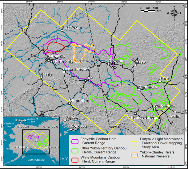
Figure 2. Map of eastern Alaska and Yukon showing Fortymile Study Area footprint and included caribou herd range boundaries. Source: Macander et al., 2020
Modeling
Existing in-situ plot data from 29 sites in Yukon-Charley Rivers National Preserve (YUCH) was collected from 2006–2015 by the US National Park Service. Visual aerial estimates of lichen cover were collected by Environment Yukon between 2010 and 2016. Additional terrestrial lichen-cover data and high-resolution RGB imagery were collected in summer 2017 from UASs at 22 forested and alpine sites across interior Alaska and western Yukon. (Data for site-level lichen presence and cover are provided for 29 UAS flights over these 22 sites in this dataset). These data were used for model training and validation. Supervised spectral classification was conducted of the ground layer using a maximum-likelihood algorithm. The classified imagery was aggregated to 30-m resolution pixels that align with Landsat pixels and calculated the proportion of each pixel that was composed of the three classes. In-depth descriptions of modeling methodology can be found in Macander et al. (2020).
Data Access
These data are available through the Oak Ridge National Laboratory (ORNL) Distributed Active Archive Center (DAAC).
ABoVE: Lichen Forage Cover over Fortymile Caribou Range, Alaska and Yukon, 2000-2015
Contact for Data Center Access Information:
- E-mail: uso@daac.ornl.gov
- Telephone: +1 (865) 241-3952
References
Macander, M.J., E.C. Palm, G.V. Frost, J.D. Herriges, P.R. Nelson, C. Roland, K.L.M. Russell, M.J. Suitor, T.W. Bentzen, K. Joly, S.J. Goetz, and M. Hebblewhite. 2020. Lichen cover mapping for caribou ranges in interior Alaska and Yukon. Environmental Research Letters 15:055001. https:doi.org/10.1088/1748-9326/ab6d38