Documentation Revision Date: 2018-07-18
Data Set Version: 1
Summary
In each fire year, 1985-2015, every burn scar was assigned a burn ID (BID) and each 30-m pixel in a burn scar was assigned that respective BID value. The BID links to a separate data file with the specific burn scar area and lists the original Landsat image pair used to calculate the dNBR for that BID. Similarly, in each fire year, every 30-m pixel in a burn scar was assigned a Landsat image pair ID (PID), indicating the original Landsat image pair that was used to calculate the dNBR in that pixel for that fire year. The PID links to a separate data file with the original Landsat image pair information.
There are 4,625 data files with this dataset. This includes 4,623 dNBR, BID, and PID data files in GeoTIFF (.tif) format and two files in comma separated (.csv) format with the BID and PID Landsat scene data utilized. The dNBR, BID, and PID data are provided in the ABoVE 30-m reference grid system and extend across 128 ABoVE grid tiles. For each dNBR data file, there is a BID data file and a PID data file for burn scars in each year (1985-2015) in the ABoVE domain. The two .csv files are BID and PID data lookup tables.

Figure 1.This figure shows the differenced Normalized Burned Ratio (dNBR) for a burn scar in 2015. The data were gridded to the 30-m ABoVE reference grid system (Loboda et al., 2017). These data are located in grid tile Bh05Bv03.
Citation
Loboda, T.V., D. Chen, J.V. Hall, and J. He. 2018. ABoVE: Landsat-derived Burn Scar dNBR across Alaska and Canada, 1985-2015. ORNL DAAC, Oak Ridge, Tennessee, USA. https://doi.org/10.3334/ORNLDAAC/1564
Table of Contents
- Data Set Overview
- Data Characteristics
- Application and Derivation
- Quality Assessment
- Data Acquisition, Materials, and Methods
- Data Access
- References
Data Set Overview
This dataset contains differenced Normalized Burned Ratio (dNBR) at 30-m resolution calculated for burn scars from fires that occurred within the Arctic Boreal and Vulnerability Experiment (ABoVE) Project domain in Alaska and Canada during 1985-2015. The fire perimeters were obtained from the Alaskan Interagency Coordination Center (AICC) and the Natural Resources Canada (NRC) fire occurrence datasets. Only burns with an area larger than 200-ha were included. The dNBR for each burn scar at 30-m pixel resolution was derived from pre- and post-burn Landsat 5, 7, and 8 scenes within a 5-km buffered area surrounding each burn scar using Landsat LEDAPS surface reflection image pairs.
In each fire year, 1985-2015, every burn scar was assigned a burn ID (BID) and each 30-m pixel in a burn scar was assigned that respective BID value. The BID links to a separate data file with the specific burn scar area and lists the original Landsat image pair used to calculate the dNBR for that BID. Similarly, in each fire year, every 30-m pixel in a burn scar was assigned a Landsat image pair ID (PID), indicating the original Landsat image pair that was used to calculate the dNBR in that pixel for that fire year. The PID links to a separate data file with the original Landsat image pair information.
Project: Arctic-Boreal Vulnerability Experiment
The Arctic-Boreal Vulnerability Experiment (ABoVE) is a NASA Terrestrial Ecology Program field campaign based in Alaska and western Canada between 2016 and 2021. Research for ABoVE links field-based, process-level studies with geospatial data products derived from airborne and satellite sensors, providing a foundation for improving the analysis and modeling capabilities needed to understand and predict ecosystem responses and societal implications.
Acknowledgments
This research received funding from the NASA Terrestrial Ecology Program, grant number NNX13AK44G.
Data Characteristics
Spatial Coverage: ABoVE core domain in Alaska and Canada
ABoVE Reference Locations:
Domain: Core ABoVE
State/territory: Alaska and the Northwest Territories, CA
ABoVE grid cells (128):
| Bh01v03 | Bh05v04 | Bh08v07 | Bh10v13 | Bh12v14 |
| Bh01v04 | Bh05v05 | Bh08v08 | Bh10v14 | Bh12v15 |
| Bh01v05 | Bh05v06 | Bh08v09 | Bh10v15 | Bh12v16 |
| Bh01v06 | Bh06v01 | Bh08v10 | Bh10v16 | Bh13v08 |
| Bh01v07 | Bh06v02 | Bh08v11 | Bh11v05 | Bh13v09 |
| Bh02v02 | Bh06v03 | Bh08v13 | Bh11v06 | Bh13v10 |
| Bh02v03 | Bh06v04 | Bh09v04 | Bh11v07 | Bh13v11 |
| Bh02v04 | Bh06v05 | Bh09v05 | Bh11v08 | Bh13v12 |
| Bh02v05 | Bh06v06 | Bh09v06 | Bh11v09 | Bh13v13 |
| Bh02v06 | Bh06v07 | Bh09v07 | Bh11v10 | Bh13v14 |
| Bh03v03 | Bh06v08 | Bh09v08 | Bh11v11 | Bh13v15 |
| Bh03v04 | Bh07v02 | Bh09v09 | Bh11v12 | Bh14v08 |
| Bh03v05 | Bh07v03 | Bh09v10 | Bh11v13 | Bh14v09 |
| Bh03v06 | Bh07v04 | Bh09v11 | Bh11v14 | Bh14v10 |
| Bh03v07 | Bh07v05 | Bh09v12 | Bh11v15 | Bh14v11 |
| Bh04v01 | Bh07v06 | Bh09v13 | Bh11v16 | Bh14v12 |
| Bh04v02 | Bh07v07 | Bh09v14 | Bh12v05 | Bh14v13 |
| Bh04v03 | Bh07v08 | Bh10v05 | Bh12v06 | Bh14v14 |
| Bh04v04 | Bh07v09 | Bh10v06 | Bh12v07 | Bh14v15 |
| Bh04v05 | Bh07v10 | Bh10v07 | Bh12v08 | Bh15v11 |
| Bh04v06 | Bh08v02 | Bh10v08 | Bh12v09 | Bh15v12 |
| Bh04v07 | Bh08v03 | Bh10v09 | Bh12v10 | Bh15v13 |
| Bh05v01 | Bh08v04 | Bh10v10 | Bh12v11 | Bh15v14 |
| Bh05v02 | Bh08v05 | Bh10v11 | Bh12v12 | Bh15v15 |
| Bh05v03 | Bh08v06 | Bh10v12 | Bh12v13 | Bh16v11 |
| Bh16v12 | ||||
| Bh16v13 | ||||
| Bh16v14 |
Spatial Resolution: 30-m
Temporal Coverage: 1985-01-01 to 2015-12-31
Temporal Resolution: annual
Study Areas (All latitude and longitude given in decimal degrees)
| Site | Westernmost Longitude | Easternmost Longitude | Northernmost Latitude | Southernmost Latitude |
|---|---|---|---|---|
| Alaska and Canada | -168.4236111 | - 101.7455556 | 71.35583333 | 50.25417 |
Data File Information
There are a total of 4,625 data files with this dataset. This includes 4,623 dNBR, BID, and PID data files in GeoTIFF (.tif) format and two files in comma-separated format (.csv) with the original Landsat image pair information used to calculate the dNBR at each pixel in each fire year and in an ABoVE grid tile.
- dNBR values were calculated for each burn scar in each fire year
- Landsat image pair ID (PID) files indicate the original Landsat image pair that was used to calculate the dNBR at each pixel in each fire year
- BID files contain the burn IDs (BID) for each fire scar in each fire year. Each BID is a unique 4-digit number assigned to an individual burn scar in the form of XYYY. Where X is 1 or 2, representing burn scars from AICC or NRC, respectively, and YYY is a three-digit ID unique identifier for a given burn scar within a fire year
File names
The files are named according to the following naming convention: ABoVE.XXX.YYYY.BhZvZ.003.proddatetime.tif
where:
ABoVE – refers to the campaign
XXX – refers to the file product type: dNBR, PID, or BID
YYYY – refers to the year of burn: 1985 - 2015
BhZvZ – refers to the grid B tile ID, where “Z” is a number (see Fig. 2, the ABOVE grid, and Loboda et al. 2017)
003 – refers to the version of the product
proddatetime – refers to the production date and time (YYYYDDDHHMMSS)
Example file names:
ABoVE.dNBR.2015.Bh16v14.003.2018020230204.tif
ABoVE.PID.2015.Bh16v14.003.2018020230204.tif
ABoVE.BID.2015.Bh16v14.003.2018020230204.tif
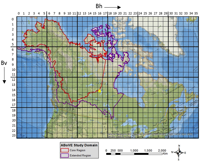
Figure 2. The ABoVE 30-m reference grid. The tile Bh16v14, in the file name examples above, is indicated with the yellow circle in the map (Loboda et al., 2017).
GeoTiff files
Table 1. Properties of the GeoTIFF files
| File type | Data Type | Valid Range (min to max) | Fill value |
|---|---|---|---|
| dNBR | 16-bit signed integer | -2999 to 2993 | -3000 |
| BID | 16-bit signed integer | 1000 to 3000 | 0 |
| PID | 16-bit signed integer | 0 to 242 | 0 |
BID and PID lookup-tables in .csv format
Two .csv files are provided with this dataset, containing BID and PID reference lookup-tables.
Burn ID (BID)
Every burn scar was assigned a burn ID (BID) and each 30-m pixel in a burn scar was assigned that respective BID value.
This file (*.csv) provides the areas of the fire scars, pre-burn and post burn path/row, year, and date of Landsat imagery used in the study. YYYY = year from 1985-2015.
Example file name: dNBR_reference_table_YYYY_BID.csv
Table 2. BID file information
| Column Heading | Units/format | Description |
|---|---|---|
| fire_year | YYYY | Year of fire from AICC and NRC sources |
| BID | XYYY | BID is a unique 4-digit number assigned to an individual burn scar in the form of XYYY. Where X is 1 or 2, representing burn scars from AICC or NRC sources, respectively. YYY is a three-digit ID unique identifier for a given burn scar within a fire year. |
| region | Alaska or Canada | |
| area_ha | ha | Burn scar area |
| satellite_pre-burn_pair1 | Landsat 5, Landsat 7, or Landsat 8 | |
| path_row_pre-burn_pair1 | PPPRRR | Path/Row of Landsat pre-burn image used to calculate the dNBR. Note leading zero. |
| image_year_pre-burn_pair1 | YYYY | Year pre-burn image acquired |
| image_julian_date_pre-burn_pair1 | DDD | Julian date pre-burn image acquired |
| image_cal_date_pre-burn_pair1 | DD/MM/YYYY | Calendar date pre-burn image acquired |
| satellite_post-burn_pair1 | Landsat 5, Landsat 7, or Landsat 8 | |
| path_row_post-burn_pair1 | PPPRRR | Path/Row of Landsat post-burn image used to calculate the dNBR |
| image_year_post-burn_pair1 | YYYY | Year post-burn image acquired |
| image_julian_date_post-burn_pair1 | DDD | Julian date post-burn image acquired |
| image_cal_date_post-burn_pair1 | DD/MM/YYYY | Calendar date post-burn image acquired |
| satellite_pre-burn_pair2 | Landsat 5, Landsat 7, or Landsat 8 | |
| path_row_pre-burn_pair2 | PPPRRR | Path/Row of Landsat pre-burn image used to calculate the dNBR. Note leading zero. |
| image_year_pre-burn_pair2 | YYYY | Year pre-burn image acquired |
| image_julian_date_pre-burn_pair2 | DDD | Julian date pre-burn image acquired |
| image_cal_date_pre-burn_pair2 | DD/MM/YYYY | Calendar date pre-burn image acquired |
| satellite_post-burn_pair2 | Landsat 5, Landsat 7, or Landsat 8 | |
| path_row_post-burn_pair2 | PPPRRR | Path/Row of Landsat post-burn image used to calculate the dNBR. Note leading zero. |
| image_year_post-burn_pair2 | YYYY | Year post-burn image acquired |
| image_julian_date_post-burn_pair2 | DDD | Julian date post-burn image acquired |
| image_cal_date_post-burn_pair2 | DD/MM/YYYY | Calendar date post-burn image acquired |
| Notes |
Landsat image pair ID (PID)
In each fire year, every 30-m pixel in a burn scar was assigned a Landsat image pair ID (PID), indicating the original Landsat image pair that was used to calculate the dNBR in that pixel for that fire year. Landsat images from 1984 were used also to derive the 1985 GeoTIFFs and are included in the file; there are no data files for 1984.
This file (*.csv) provides a cross reference from the assigned Landsat image pair ID (PID) to the respective pre-burn and post burn path, row, year, and date of Landsat imagery used in the study. YYYY=year from 1985-2015.
Example file name: dNBR_reference_table_YYYY_PID.csv DD/MM/YYYY
Table 3. PID file information
| Column Heading | Units/format | Description |
|---|---|---|
| image_year_pre-burn | YYYY | Year pre-burn image acquired |
| PID | In each fire year, every 30-m pixel in a burn scar was assigned a Landsat image pair ID (PID), indicating the original Landsat image pair that was used to calculate the dNBR in that pixel for that fire year. | |
| landsat_pre-burn | Landsat 5, Landsat 7, or Landsat 8 | |
| path_row_pre-burn | PPPRRR | Path/Row of Landsat pre-burn image used to calculate the dNBR. Note leading zero. |
| image_julian_date_pre-burn | DDD | Julian date pre-burn image acquired |
| image_cal_date_pre-burn | DD/MM/YYYY | Calendar date pre-burn image acquired |
| landsat_post-burn | Landsat 5, Landsat 7, or Landsat 8 | |
| path_row_post-burn | PPPRRR | Path/Row of Landsat post-burn image used to calculate the dNBR. Note leading zero. |
| image_year_post-burn | YYYY | Year post-burn image acquired |
| image_julian_date_post-burn | DDD | Julian date post-burn image acquired |
| image_cal_date_post-burn | DD/MM/YYYY | Calendar date post-burn image acquired |
Companion files
There are two companion files with this dataset described below.
Table 4. Companion files
| File name | Description |
|---|---|
| ABoVE_Fire_Severity_dNBR.pdf | A pdf of this guide document |
| ABoVE_Burn_Severity_Product_Users_Guide.pdf | A user's guide in pdf format of the ABoVE Burn Severity Product (as sets of three-band GEOTIFF images) |
Application and Derivation
These data are designed to quantify fire-induced changes in tundra with a specific aim to assess the region’s vulnerability to on-going and future environmental change and the changes to carbon cycling in this ecosystem.
Quality Assessment
Caveats and Known Problems
For a small number of fires, the dNBR was unable to be calculated for a portion or the entirety of the fire perimeters due to a lack of valid data inputs.
Data Acquisition, Materials, and Methods
Overview
The differenced Normalized Burned Ratio (dNBR) was calculated for each burn scar from fires that occurred within the Arctic Boreal Vulnerability Experiment (ABoVE) Project domain in Alaska and Canada during 1985-2015. The fire perimeters were obtained from the Alaskan Interagency Coordination Center (AICC; https://fire.ak.blm.gov/) and the Natural Resources Canada (NRC; https://www.nrcan.gc.ca/) datasets. Only burns within the core ABoVE domain and whose areas are larger than 200-ha were included.
Annual dNBR data were derived from pre- and post-burn Landsat 5, 7, and 8 scenes over the burn scars. Pre- and post-fire products used in this study were from Landsat 5 Thematic Mapper (TM), Landsat 7 Enhanced Thematic Mapper Plus (ETM+), and Landsat 8 Operational Land Imager (OLI)/Thermal Infrared Sensor (TIRS).
The annual dNBR data were gridded to the ABoVE 30-m grid system, resulting in 128 grid tiles with burn scars and derived dNBR for the study period. Data files include the specific ABoVE grid designation and the year.
Pre- and Post-burn Image Selection
The pre- and post-burn images were selected based on the following criteria:
- Images must contain a minimal amount of clouds and cloud shadows within the burn scars.
- The following combinations of the pre- and post-image pairs are allowed: OLI-OLI, TM-TM, ETM+-ETM+, TM-ETM+, ETM+-TM. The combination of OLI and non-OLI images was excluded because of the differences in band ranges between the OLI and prior sensors.
- The preferred acquisition date for the pre- (post-) burn images was chosen based on the following strategy: Mid-May to late-June of the year before (after) fire > early-July to mid-September (before snow onset) of the year before (after) fire > snow-free image from the year of fire before (after) fire occurs.
The Monitoring Trends in Burn Severity (MTBS; https://www.mtbs.gov/) image pairs over Alaska were used as a basis for the chosen Landsat pairs over the Alaskan burn scars; however, any MTBS image pairs that did not meet our criteria were dropped and new image pairs were chosen (refer also to the companion file ABoVE_Burn_Severity_Product_Users_Guide.pdf).
dNBR Calculations
The Normalized Burn Ratio differencing (dNBR) was calculated within a 5-km buffered area surrounding each burn scar using Landsat LEDAPS (Masek et al., 2006) surface reflection image pairs:
dNBR = NBRpre-burn – NBRpost-burn
where,
NBR = (near-infrared (NIR) - shortwave-infrared (SWIR)2.1) / (NIR + SWIR2.1)
The dNBR values were set to -2500 for those pixels that were affected by invalid land observations (i.e. cloud, cloud shadow, ice/snow and water) according to the QA bands associated with LEDAPS surface reflectance data. In cases where scars were in close proximity and there could have been image overlapping, the dNBR of the overlapping regions were set to the highest value at each pixel.
Data Access
These data are available through the Oak Ridge National Laboratory (ORNL) Distributed Active Archive Center (DAAC).
ABoVE: Landsat-derived Burn Scar dNBR across Alaska and Canada, 1985-2015
Contact for Data Center Access Information:
- E-mail: uso@daac.ornl.gov
- Telephone: +1 (865) 241-3952
References
Loboda, T.V., E.E. Hoy, and M.L. Carroll. 2017. ABoVE: Study Domain and Standard Reference Grids, Version 2. ORNL DAAC, Oak Ridge, Tennessee, USA. https://doi.org/10.3334/ORNLDAAC/1527
Masek, J.G., Vermote, E.F., Saleous, N.E., Wolfe, R., Hall, F.G., Huemmrich, K.F., Feng, G., Kutler, J., & Teng-Kui, L. (2006). A Landsat surface reflectance dataset for North America, 1990-2000. Geoscience and Remote Sensing Letters, IEEE, 3, 68-72. https://doi.org/10.1109/LGRS.2005.857030