The 1994 field season is just complete and investigators will be carrying out data processing and analysis tasks throughout 1994 and 1995. Significant formal publication of scientific results is expected in late 1995 or early 1996. However, some of the initial results which were presented during the science team meetings are sufficiently startling to warrant immediate advertisement, in spite of their preliminary nature. View preliminary results for:
View a Summary of BOREAS Results.
 Two points are worth noting: first, the SSA is generally associated with lower Bowen ratio values (i.e. higher latent heat fluxes) over the period and; second, the values are consistently higher than the science team members expected prior to the field season. Most of the time, the area-averaged daytime sensible heat flux is greater than the latent heat flux (Bowen ratio greater than one). These data were acquired under a wide range of radiation conditions, from smoky and cloudy through to clear-sky; if anything, Bowen ratios were consistently higher under clear-sky conditions. These high Bowen ratios suggest significant stomatal control by the vegetation. Other data collected by the TF and TE teams support this and indicate that under warm, clear-sky conditions, the coniferous trees' stomata almost completely close down in response to the associated high atmospheric vapor pressure deficit, presumably a self-protective mechanism to prevent desiccation of the foliage.The continuous program of radiosonde launches in BOREAS complemented the airborne and tower-mounted flux measurements. The effects of the large sensible heat fluxes released into the lower atmosphere over the region manifested themselves in greatly increased turbulence over the forest relative to the adjoining agricultural areas and impressively deep boundary layer development during the spring and early summer. Atmospheric boundary layer heights of 3000m or more were observed frequently during the field phase.Figure 11 shows fluxes of CO2 measured by the Twin Otter at a mean altitude of 35m over the transect between the Southern Study Area (SSA) and the Northern Study Area (NSA). Each value is the mean over a distance of approximately 40 km. The simple ratio vegetation index (SR), which is the ratio of near infrared over visible (red) radiation as measured with a Skye sensor, is also shown. This sensor provides a measure of the green vegetation directly below the aircraft, while the flux represents the assimilation of CO2 by the vegetation upwind of the aircraft (see Schuepp et al. 1992). Since most of this flight was flown directly into the wind, the flux system and the spectrometer effectively sensed the same surface. The flight, which lasted from 1811-2225 GMT, (covering the local midday and early afternoon) was done during clear conditions on June 6, 1994. However, because of the time of day, the solar radiation over the last 300 km decreased from 780 Wm2 to 560 Wm2. Even with this change in radiation, a reasonably high correlation r = 0.81 is observed between CO2 flux and SR; the correlation should increase further when the effects of radiation, vapor pressure deficit and footprint are accounted for. This result shows promise for estimating CO2 exchange rates from satellite-derived spectral data. Figure 11 and accompanying information were provided by Desjardins (pers. comm.) of AFM-4.The AFM-1 team operated its Long-EZ flux aircraft in IFC-93 as well as during the 1994 IFC's. In IFC-93, flux measurements were made with the aircraft mainly along a transect within the Southern Study Area (SSA) and in "asterisk" patterns centered on the Old Jack Pine flux tower. Variables measured from both the aircraft and tower include turbulent fluxes of momentum, sensible and latent heat, and CO2. Figure 12 presents preliminary calculations of the fluxes along the transect along with values of the normalized difference vegetation index (NDVI) measured by the aircraft at the same time. These values are composites of three flights, all around midday on August 26, 28, and 30, 1993. Each flux value plotted in Figure 12 was calculated over a 20 second window, which corresponds to a 1 km flight path.While these data are preliminary, and were composited from only 3 flights, some surface features are apparent. The areas of sparse or no vegetation are associated with low values of both NDVI and latent heat flux. High values of both quantities are linked to the denser forest stands. The remainder of the transect is mixed with scales too small to resolve with the current data. It is expected that when more data are processed, resolution of the more heterogeneous areas will improve. Figure 12 and accompanying information were provided by Crawford (pers. comm.) of AFM-1.Figure 13 was produced from analyses of the short wave radiation measurements made by the mesoscale network of automatic meteorological stations (AMS) operated by AFM-7. Each AMS is equipped with upward and downward looking radiometers which allows for the direct calculation of albedos for the different vegetation covers found in the BOREAS region. The grassland areas around Meadow Lake and Saskatoon show albedos of between 0.19 and 0.26, depending on solar angle, while the coniferous covers (Jack Pine and Spruce) show almost constant albedos of between 0.07 and 0.11. The fully foliated aspen cover with a total (canopy plus understory) leaf area index of between 4 and 5 has intermediate values. The variation in albedo during the day (and with solar angle) is a function of the heterogeneity of the surface cover and hence the amount of shadowing in the canopy: the spire-shaped crowns of the black spruce canopies generate a large proportion of shadowed area while the relatively diffuse deciduous and grass canopies behave more like classical turbid media with regard to radiative transfer.Figure 14 illustrates the influence of smoke on the Photosynthetically Active Radiation (PAR) flux as observed by an AMS station in the NSA. In the absence of clouds, a moderately thick smoke layer greatly reduced the amount of PAR reaching the surface on the 30 July. Figure 13 and 14 and accompanying information were provided by Betts (pers. comm.) of AFM-8.A goal of the AFM group is to apply results from large-scale field experiments like BOREAS to improve the performance of atmospheric general circulation models (GCMs). Data from a previous land surface experiment, the First ISLSCP Field Experiment (FIFE), were used by Betts et al. (1993) to improve the land surface and boundary layer components in the European Center for Medium Range Weather Forecasting (ECMWF) model. This work led to a remarkable increase in precipitation forecast skill for the anomously wet summer of 1993 in the U.S. Midwest (Betts et al., 1994; Viterbo et al., 1994). A similar methodology is now being used to test and improve the land-surface parameterizations in the National Meteorological Center (NMC) mesoscale model (Mitchell et al., 1994).ECMWF and NMC provided operational forecasts to BOREAS, and ECMWF will produce two special research data sets. One is an hourly time-series of model output at full vertical resolution (31 levels) for 7 "grid-point" sites (representative of 50 x 50 km) which form a SW-NE cross-section across the BOREAS region; these are intended for direct comparison with time-series data collected at instrumented sites. The second data set will be a 4 x 4 array of cells of hourly model output (each cell averaged over 4 x 4 grid points), again at full vertical spatial resolution (31 levels) with full model diagnostics, to define the large-scale spatial structure across the BOREAS region. These model products will be compared with BOREAS data to test and improve the global model, and at the same time the biases between model and observations will be used to correct the global model output, so that the corrected model fields can be used to drive ecosystem models over the whole BOREAS region.
View a description of the AFM teams and their proposals.
At the time of writing, the surface, airborne and satellite data from winter (FFC-W) and thaw campaigns (FFC-T) of 1994 are being analyzed in order to develop improved algorithms for estimating snow cover, depth and temperature from satellite optical and microwave data. The work will concentrate on the problems of satellite remote sensing of snow water equivalent, which can be very difficult where there is significant forest canopy.During the growing season IFCs, the HYD-1 team made soil moisture measurements and conducted a range of soil hydraulic experiments at all the non-saturated TF sites in the study areas. Figure 19 provided by Cuenca (pers. comm.) of HYD-1 shows a succession of soil moisture profiles made at the Old Jack Pine site in the SSA: note how the very coarse soils typical of the upland areas of this region, in texture somewhere between sand and gravel, retain very little water for access by the trees.During the growing season of 1994, a truck-mounted C-band weather radar was located near Paddockwood just to the south of the prairie-forest boundary along the southern edge of the SSA. Figure 20 provided by Krauss and Lettenmaier (pers. comm.) of HYD-9 shows the accumulated precipitation during the week prior to IFC-2 (July 13-19) as estimated by the radar. This was a period of intense storm activity in the SSA. Peak accumulations occurred near the center of the modeling subarea (small rectangle in Figure 20) with totals in excess of 125 mm estimated for the area just east of the OBS tower. Accumulations decreased to the southeast, with a strong gradient along the line from the OJP to the YJP and fen towers. The area surrounding the OA site, in Prince Albert National Park in the southwestern corner of the SSA, had much smaller precipitation accumulations, around 25 mm for the week. These data will be compared directly with the airborne and surface heat flux measurements.
View a description of the HYD teams and their proposals.
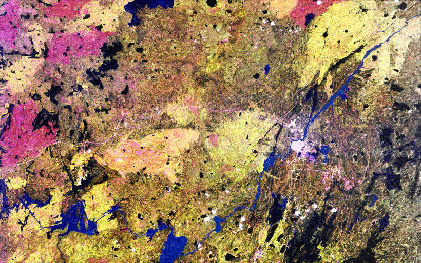
FPAR was estimated from in-situ optical and direct measurements for the many vegetation covers represented at the auxiliary sites. These and other measurements will be used to develop relationships between leaf area index, FPAR and satellite data to estimate regional scale net primary productivity from orbit. Other investigator teams will concentrate on measurements of canopy architecture, moisture content and electrical properties (i.e., dieletric constant) of vegetation and soils to acquire data for optical and microwave scattering models of forest canopies.The NASA Jet Propulsion Laboratory (JPL) airborne Synthetic Aperture Radar (SAR) was flown on-board the NASA DC-8 over both the northern and southern study areas. Early results indicate that species and above-ground biomass may be identified from images such as the one shown in Figure 21 provided by Saatchi (pers. comm.) of RSS-16. The image was produced by combining radar data for three wavelengths (68 cm displayed as red, 24 cm displayed as green, and 6 cm displayed as blue). The SAR image covers the young jack pine site and a portion of the fen site in the SSA. Mature jack pine forest can be easily identified as the bright red and orange areas, younger jack pine stands appear as yellow or green. Clearings and fens are depicted as blue. Other results indicate that longer wavelength radar can be used to identify different age stands. These and other data will be analyzed further using microwave backscatter models such as the one described by Lang et al. (1994) to partition the biomass into bole, branch and foliage components and to examine ground surface effects.Analysis of optical satellite data have revealed the important role of fire in the carbon dynamics of the region. Figure 22 is a Landsat image of the NSA; the large fire scars from a succession of fires in the area are clearly visible. Fire is probably the dominant mechanism for releasing the surface carbon stocks back to the atmosphere in this biome; analyses of these and similar data should permit a precise quantification of the fire frequency.
During BOREAS, the Space Shuttle overflew the Southern Study Area and took SAR (Synthetic Apature Radar) images of the entire area twice, once in April 1994 and once in October 1994. The Shuttle SAR images are available from JPL.
View a description of the RSS teams and their proposals.
Measurements made at each of the forested tower flux sites included C distribution in the soil, lichens or mosses, understory shrubs and overstory trees; leaf photosynthesis by the moss or lichens, understory shrubs and overstory trees; leaf, branch, stem and root net primary production and respiration; and soil surface CO2 flux.Preliminary data provided by Gower (pers. comm.) of TE-6 indicate that the carbon content in wood and foliage tissue and soil surface CO2 fluxes differ among similar-aged forests types at each study site and between study sites for a similar vegetation type (Figure 17) and that maintenance respiration rates for boreal tree species are positively correlated to tissue nitrogen concentration. Collectively, the C flux measurements will be used to determine if the terrestrial ecosystems are a net C sink or source. In addition they will be compared to net ecosystem CO2 flux as determined by eddy correlation for the same forest ecosystems to test different scaling approaches. Stable isotope analyses are also being conducted to determine the extent of recycling of CO2 within terrestrial ecosystems and their interaction with the atmosphere, as well as reconstruct past temporal patterns of leaf gas exchange.
View a description of the TE teams and their proposals.
Figures1 15 and 16 show time-series of midday evaporative fractions (latent heat flux divided by the sum of the latent and sensible heat fluxes) and CO2 fluxes, respectively, as reported by some of the TF sites during the intensive field campaigns. Again, we see some surprisingly low evaporative fractions (corresponding to high Bowen ratios) over most of the sites most of the time. These are associated with much lower CO2 fluxes than are commonly observed by temperate forests, see for example Verma et al. 1986. The exception to this generalization is the Old Aspen site in the SSA which after a rapid leaf-out in IFC-1 maintained the highest evaporation and carbon drawdown rates of all the sites. By contrast, the SSA Old Jack Pine site (TF-5: Baldocchi) and the SSA Old Black Spruce site (TF-9: Jarvis) reported mean growing season evapotranspiration rates of around 1.3 to 2.0 mm/day, respectively. These two sites more or less bracket the range of wet (black spruce) and dry (jack pine) conditions over most of the BOREAS sites and present us with a new and unexpected picture of the partitioning of energy at the surface in this region. These findings are consistent with those of the AFM group summarized in the previous section.
View a description of the TF teams and their proposals.
BOREAS investigators have been directly quantifying the fluxes of radiatively important trace gases (e.g. CO2 and CH4) and those gases which could affect the oxidant balance of the troposphere (e.g. NMHC, CO). The principal emphasis will be on carbon dynamics, particularly the role of environmental controls on carbon storage and fluxes. This work was coordinated with studies of moisture and energy fluxes and with studies of the rates of carbon turnover and accumulation in soils using radiocarbon (14C). Measurements of 14C in accumulating soil organic matter, together with measures of bulk density and carbon content, will provide longer term rates of carbon burial into boreal soils. For decadal and shorter timescales, the amount of carbon labeled with excess 14C produced during atmospheric weapons testing in the late 1950's and early 1960's will enable us to compare more recent carbon accumulation with longer term averages. Both of these estimates may be used as context in which to interpret the net ecosystem fluxes measured during the main BOREAS field season. This work is being carried out in close cooperation with field groups who are determining the primary controls on trace gas emissions. We hypothesize that the same factors (e.g., soil drainage, flooding by beaver activity, time since fire disturbance, etc.) will determine both trace gas biogeochemistry and net carbon burial.Moisture (time-domain reflectometry, TDR) temperature (thermistor) and gas probe arrays were established at a number of upland sites in both the NSA and SSA in 1993. An example of the sort of gas distribution data that will be obtained from these arrays is illustrated in Figure 18 provided by Striegl (pers. comm.) of TF-4. These are CO2 concentration versus depth data obtained from the Jack Pine sites in the SSA. Note that the concentration gradients in all these soils shows them to be a source of CO2 to the atmosphere; also note the differences between the young (YJP) and the old (OJP) jack pine sites.
View a description of the TGB teams and their proposals.
