Get Data
Summary:
This data set contains 5-minute land use maps for agricultural activity in Amazonia. The data set was produced by the statistical fusion of agricultural census data from Brazil, Columbia, Bolivia, and Peru with the land cover data product from the Global Land Cover Facility. These land use maps indicate the estimated total amount of cropland and pasture (natural and planted) for the Amazon and Tocantins River basins in 1995 and 1980 and are suitable for use in models or other similar purposes. Data are provided in the netCDF format and the ARC/INFO GRID ASCII format.
The 1995 data were generated from a fusion of agricultural census data and a satellite classification, and are described in Cardille, Foley, and Costa (2002). The fusion technique merges agricultural census data from Brazil , Columbia, Peru, and Bolivia (Figure 1) with land cover data from the University of Maryland Global Land Cover Facility 1-km classification (Figure 2). This technique was used to derive an estimate of the mid-1990s total agriculture surface for the region, which was then apportioned according to agriculture census data into cultivated area, natural pasture, and planted pasture.
The 1980 maps, including only the Brazilian portion of the Amazon/Tocantins river drainage basins (Figure 3), were created by scaling the mid-1990s snapshots backward in time using the relative increase or decrease in agriculture, as derived from mid-1980s census data and United Nations Food and Agriculture Organization (FAO) data (Cardille and Foley, 2003).
Figure 1. Major administrative boundaries in the Amazon and Tocantins river drainage basins for 1995 agricultural land cover data. Area includes portions of Brazil, Columbia, Peru, and Bolivia (Cardille, Foley, and Costa, 2002).
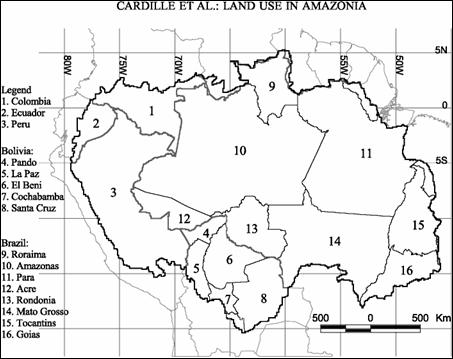
Figure 2. Global Land Cover Facility land cover classifications for the Amazon and Tocantins basins (Cardille, Foley, and Costa, 2002).
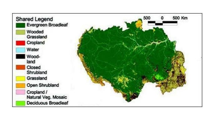
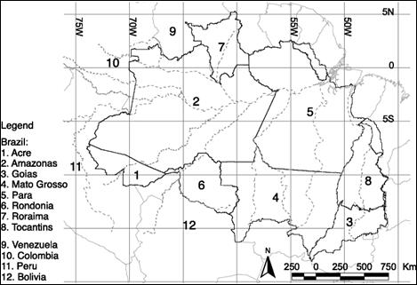
Figure 3. Major administrative boundaries in the Amazon and Tocantins river drainage basins for 1980 agricultural land cover data. Only selected areas within the political borders of Brazil were used for the 1980 study (Cardille and Foley, 2003).
Data Citation:
Cite this data set as follows:
Cardille, J.A., J.A. Foley, and M.H. Costa. 2008. LBA-ECO LC-04 Satellite/Census-Based 5-Minute Land Use Data, Amazonia: 1980 and 1995. Data set. Available on-line [http://daac.ornl.gov] from Oak Ridge National Laboratory Distributed Active Archive Center, Oak Ridge, Tennessee, U.S.A.doi: 10.3334/ORNLDAAC/906.
Implementation of the LBA Data and Publication Policy by Data Users:
The LBA Data and Publication Policy [http://daac.ornl.gov/LBA/lba_data_policy.html] is in effect for a period of five (5) years from the date of archiving and should be followed by data users who have obtained LBA data sets from the ORNL DAAC. Users who download LBA data in the five years after data have been archived must contact the investigators who collected the data, per provisions 6 and 7 in the Policy.
This data set was archived in January of 2009. Users who download the data between January 2009 and December 2014 must comply with the LBA Data and Publication Policy.
Data users should use the Investigator contact information in this document to communicate with the data provider. Alternatively, the LBA Web Site [http://lba.inpa.gov.br/lba/] in Brazil will have current contact information.
Data users should use the Data Set Citation and other applicable references provided in this document to acknowledge use of the data.
Table of Contents:
- 1 Data Set Overview
- 2 Data Characteristics
- 3 Applications and Derivation
- 4 Quality Assessment
- 5 Acquisition Materials and Methods
- 6 Data Access
- 7 References
1. Data Set Overview:
Project: LBA (Large-Scale Biosphere-Atmosphere Experiment in the Amazon)
Activity: LBA-ECO
LBA Science Component: Land Use and Land Cover
Team ID: LC-04 (Foley / Costa)
The investigators were Botta, Aurelie; Cardille, Jeffrey Alan; Costa, Marcos Heil; Foley, Jonathan A. and Lenters, John D. You may contact Foley, Jon (jfoley@wisc.edu)
LBA Data Set Inventory ID: LC04_Land_Use_5min
The goal of our NASA funded LBA work is to investigate how the terrestrial ecosystem and water resources of the Amazon basin are impacted by changing environmental conditions and human activity. To achieve this goal, we have been developing new comprehensive regional models and data sets to describe the behavior of terrestrial ecosystems and hydrological resources of the Amazon River Basin. This high-resolution land use / land cover data set is a product of those efforts.
The data were generated from a fusion of agricultural census data and a satellite classification, and are described in Cardille, J.A., J.A. Foley, and M.H. Costa (2002). The fusion technique merges agricultural census data from countries of the basin (including Brazil) with land cover data from the University of Maryland Global Land Cover Facility 1-km classification. This technique was used to derive an estimate of the mid-1990s total agriculture surface for the region, which was then apportioned according to agriculture census data into cultivated area, natural pasture, and planted pasture.
The 1980 maps were created by scaling the mid-1990s snapshots backward in time using the relative increase or decrease in agriculture, as derived from mid-1980s census data and United Nations Food and Agriculture Organization (FAO) data (Cardille and Foley, 2003).
For additional information see the related poster included as a companion file.
Title: "A New Five-Minute Land Use Data Set for Amazonia Produced from Satellite-Based and Agricultural Census-Based Data "
2. Data Characteristics:
Sixteen files are included. These include 4 data files for each time period that are provided in 2 formats: netCDF (.nc) files and ARC/INFO GRID ASCII formatted text files (*.txt).
Total Agriculture:
Totag80s.nc, Totag80s.txt, Totag90s.nc, and Totag90s.txt
Cultivated:
Cul80s.nc, Cul80s.txt, Cul90s.nc, and Cul90s.txt
Natural Pasture:
Pasnat80s.nc, Pasnat80s.txt, Pasnat90s.nc, and Pasnat90s.txt
Planted Pasture:
Paspla80s.nc, Paspla80s.txt, Paspla90s.nc, and Paspla90s.txt
These files are gridded at 5-minute latitude by longitude (0.8333333 decimal degrees or ~9km at the equator) resolution for the entire Amazon/Tocantins river drainage basins (21S - 6N; 45W - 80W). The grid contains 420 cloumns (longitude dimension) and 324 rows ( latitude dimension) and is not projected. The files contain the estimated proportions of: total agriculture (totag), cultivated area (cul), natural pasture (pasnat), and planted pasture (paspla) in each grid cell in either the mid-1980s or mid-1990s. The 1980 data covers only the Brazilian portion of the Amazon/Tocantins river drainage basins while the 1995 data also includes areas in Columbia, Peru, and Bolivia. Proportions are expressed as parts per 10,000 so that, for example, a value of 8945 means that 89.45% of the given pixel is estimated by this procedure to be used for agricultural activity.
Site boundaries: (All latitude and longitude given in degrees and fractions)
| Site (Region) | Westernmost Longitude | Easternmost Longitude | Northernmost Latitude | Southernmost Latitude | Geodetic Datum |
|---|---|---|---|---|---|
| Amazon Basin (Amazon Basin) | -80 | -45 | 6 | -21 | World Geodetic System, 1984 (WGS-84) |
Time period:
- The data set covers the period 1980/01/01 to 1995/12/31.
- Temporal Resolution: Annual
Platform/Sensor/Parameters measured include:
- COMPUTER MODEL / AVHRR (ADVANCED VERY HIGH RESOLUTION RADIOMETER) / LAND COVER
- VEGETATION SURVEY / HUMAN OBSERVER / LAND COVER
3. Data Application and Derivation:
These land use maps indicate the total amount of cropland and pasture for the Amazon and Tocantins River basins in the mid-1990s and is suitable for use in models or other similar purposes. See the related publications for additional applications.
4. Quality Assessment:
These data files are generated by a fusion of two data sources which may contain errors in position and value. In particular, census variables may be susceptible to under- and over-estimation for political, logistical, and economic reasons. While we do not treat these errors of estimation directly, it appears that the fusion technique smoothes extreme/unlikely values in the census data.
5. Data Acquisition Materials and Methods:
These data were generated from a fusion of agricultural census data and a satellite classification, and are described fully in the related paper (Cardille, Foley, and Costa, 2002).
The fusion technique merges agricultural census data from countries of the basin (including Brazil) with land cover data from the University of Maryland Global Land Cover Facility 1-km classification. This technique was used to derive an estimate of the mid-1990s total agriculture surface for the region, which was then apportioned according to agriculture census data into cultivated area, natural pasture, and planted pasture.
The 1980 maps were created by scaling the mid-1990s snapshots backward in time using the relative increase or decrease in agriculture, as derived from mid-1980s census data and United Nations Food and Agriculture Organization (FAO) data (Cardille and Foley, 2003). The 1980 data covers only the Brazilian portion of the Amazon/Tocantins river drainage basins.
Sensors used include:
- AVHRR (ADVANCED VERY HIGH RESOLUTION RADIOMETER)
- HUMAN OBSERVER
6. Data Access:
This data is available through the Oak Ridge National Laboratory (ORNL) Distributed Active Archive Center (DAAC).
Data Archive Center:
Contact for Data Center Access Information:
E-mail: uso@daac.ornl.gov
Telephone: +1 (865) 241-3952
7. References:
Cardille, J.A., J.A. Foley, and M.H. Costa. 2002. Characterizing patterns of agricultural land use in Amazonia by merging satellite classifications and census data. Global Biogeochemical Cycles 16(3):Article-1045.
Cardille J.A. and J.A. Foley. 2003. Agricultural land-use change in Brazilian Amazonia between 1980 and 1995: Evidence from integrated satellite and census data. Remote Sensing of Environment 87(4):551-562.doi:10.1016/j.rse.2002.09.001