Get Data
Revision Date: August 12, 2014
Summary:
This data set provides coordinates for points at the mouth of tributaries of the Acre River in the Tri-national River Basin in South America. Three Global Positioning System (GPS) readings were made at the outlet of each tributary and the average of the three readings is reported.
The Tri-national River Basin is located in the tri-national frontier region of Madre de Dios, Peru, Acre, Brazil, and Pando, Bolivia (known as the MAP region). The MAP region is approximately 300,000 km2. The Acre River flows through Brazil, Bolivia, and Peru. Data on the basin drainage network from the Digital Elevation Model (DEM) Shuttle Radar Topography Mission (SRTM) was obtained as a source of information for the border areas. The GPS readings were part of an assessment of the reliability of the DEM/SRTM drainage network data (Maldonadoae and Brown, 2003).
There is one data file in comma-delimited (.csv) format and one compamion file (.pdf) with this data set.
DATA QUALITY STATEMENT: This data set provides GPS coordinates only and is not associated with any additional measurements. There is no associated research documentation.
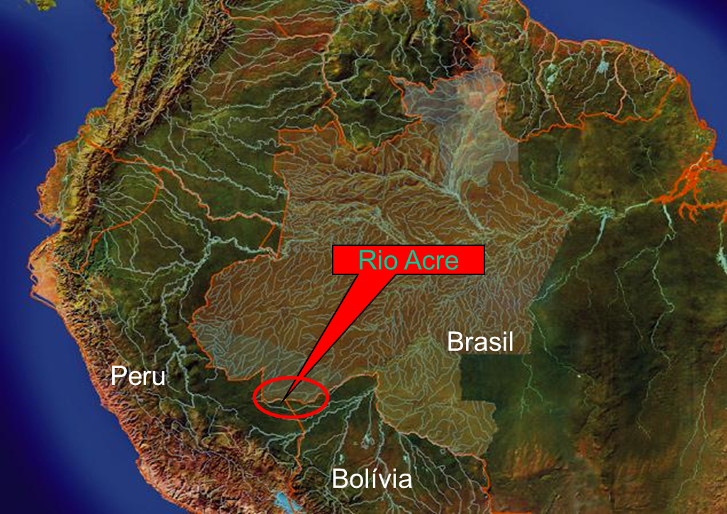
Figure 1. The location of the Tri-national River Basin (Maldonado and Brown, 2003).
Data Citation:
Cite this data set as follows:
Maldonado, M., and I.F. Brown. 2014. LBA-ECO LC-02 Tributary Coordinates, Acre River, Tri-national River Basin: 2003-2004. Data set. Available on-line [http://daac.ornl.gov] from Oak Ridge National Laboratory Distributed Active Archive Center, Oak Ridge, Tennessee, USA. http://dx.doi.org/10.3334/ORNLDAAC/1243
Implementation of the LBA Data and Publication Policy by Data Users:
The LBA Data and Publication Policy [http://daac.ornl.gov/LBA/lba_data_policy.html] is in effect for a period of five (5) years from the date of archiving and should be followed by data users who have obtained LBA data sets from the ORNL DAAC. Users who download LBA data in the five years after data have been archived must contact the investigators who collected the data, per provisions 6 and 7 in the Policy.
This data set was archived in August 2014. Users who download the data between August 2014 and September 2019 must comply with the LBA Data and Publication Policy.
Data users should use the Investigator contact information in this document to communicate with the data provider.
Data users should use the Data Set Citation and other applicable references provided in this document to acknowledge use of the data.
Table of Contents:
- 1 Data Set Overview
- 2 Data Characteristics
- 3 Applications and Derivation
- 4 Quality Assessment
- 5 Acquisition Materials and Methods
- 6 Data Access
- 7 References
1. Data Set Overview:
Project: LBA (Large-Scale Biosphere-Atmosphere Experiment in the Amazon)
Activity: LBA-ECO
LBA Science Component: Land Use and Land Cover
Team ID: LC-02 (Brown / Silveira / Esteves)
The investigators were Maldonado, Monica Julissa de Los Rios; Brown, Irving Foster; Melo, Antonio Willian Flores de; and Serrano, Rodrigo Otavio Perea. You may contact Maldonado, Monica Julissa de Los Rios (monica_julissa@yahoo.com.br).
LBA Data Set Inventory ID: LC02_Stream_Acre
This data set provides coordinates for points at the mouth of tributaries of the Acre River in the Tri-national River Basin in South America. Three Global Positioning System (GPS) readings were made at the outlet of each tributary and the average of the three readings is reported.
The Tri-national River Basin is located in the tri-national frontier region of Madre de Dios, Peru, Acre, Brazil, and Pando, Bolivia (known as the MAP region). The MAP region is approximately 300,000 km2. The Acre River flows through Brazil, Bolivia, and Peru. Data on the basin drainage network from the Digital Elevation Model (DEM) Shuttle Radar Topography Mission (SRTM) was obtained as a source of information for the border areas. The GPS readings were part of an assessment of the reliability of the DEM/SRTM drainage network data (Maldonadoae and Brown, 2003).
2. Data Characteristics:
There is one comma-delimited data file with this data set:
LC02_Tributaries_Acre.csv. This file provides the average of three GPS readings as X and Y coordinates for 60 areas along the Acre River. Country names are included.
The X and Y Coordinates are in the WGS_1984_UTM_Zone_19S system.
Note: The UTM zone information was not provided with the data set, however, the UTM Zone 19S covers the MAP region (Perz et al., 2013). The datum (WGS 1984) was provided.
Example data records:
| Number, X, Y, Name, Country 1, 353043, 8776202, Rio Blanco, Peru 2, 359427, 8777190, Pitiaco, Brazil 3, 359826, 8777442, Curiaco, Brazil ... 58, 523094, 8782449, Virtude, Bolivia 59, 521815, 8784861, Recanto, Brazil 60, 527440, 8781918, Bahia, Brazil |
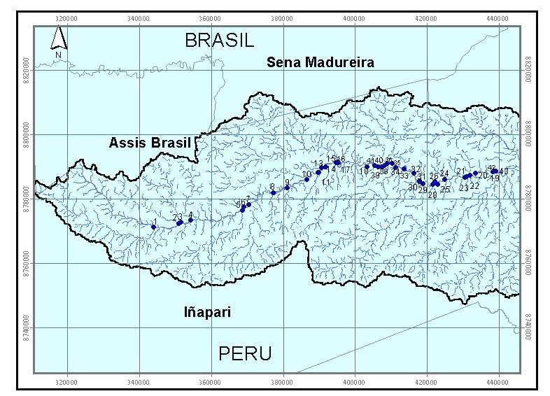 |
The points where the GPS readings were taken along the Acre
River, from west to east: 1- Rio Blanco 2- Pitiaco 3- Curiaco 4- Ascaiaqui 5- Plata 6- Josefina 7- Sofia 8- Santa Helena 9- Igarapé 10- Matança 11- Josefina 12- Igarapé 1 13- Igarapé 2 14- Igarapé 3 15- Igarapé 4 16- Dos Patos 17- Patori 18- Igarapé 5 19- Yaverija 20- Lima 21- Nequinho 22- São Francisco 23- Nova Esperança 24- Chapiana 25- Igarapé 6 26- Dois Irmãos I 27- Dois Irmãos II 28- Aliança 29- Bélgica 30- Murici I 31- São Paulo 32- Murici II 33- Caxetim 34- Rio Branco 35- Igarapé 7 36- São Lorenço 37- Igarapé 8 38- Igarapé 9 39- Igarapé 10 40- Igarapé 11 41- Anaya 42- Edilson 43- Cascata |
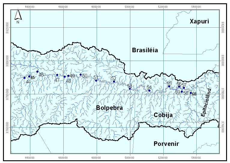 |
44 São Miguel 45 Cotovelo 46 São Pedro 47 Paxiuba 48 Noaya 49 Bufeo 50 Porto Carlos 51 Piaui 52 Banana 53 Buenos Ayres 54 Baixa Verde 55 Igarapé 12 56 Igarapé 13 57 Nazaré 58 Virtude 59 Recanto 60 Bahia |
Figure 1. Maps depicting the points where the GPS readings were taken. From west to east, the top map provides the points for areas 1-43 and the lower map provides the points for areas 44-60. The X and Y coordinates for the GPS readings are provided in the data file with this data set.
Companion file: LBA_poster_Maldonado_Brown.pdf: This is a poster presentation of a reliability assessment of hydrographic data for the tri-national basin. The GPS readings were part of the assessment. The information is in Portuguese.
Site boundaries: (All latitude and longitude given in decimal degrees)
NOTE: The data center has provided the coordinates below. The tributary GPS points are located within the MAP area provided, but the coordinates do not belong to any of the 60 GPS points.
| Site (Region) | Westernmost Longitude | Easternmost Longitude | Northernmost Latitude | Southernmost Latitude | Geodetic Datum |
|---|---|---|---|---|---|
| Coordinates encompass the tri-national region: Madre de Dios, Peru, Acre, Brazil, and Pando, Bolivia (MAP region) | -70.5900 | -68.7408 | -9.0658 | -11.99 | World Geodetic System, 1984 (WGS-84) |
Time period:
- The data set covers the period 2003/02/01 to 2004/07/30
- Temporal Resolution: Three GPS readings were made between 2003/02/01 and 2004/07/30
Platform/Sensor/Parameters measured include:
- GPS (GLOBAL POSITIONING SYSTEM SATELLITES) / SATELLITES / RIVERS/STREAMS
3. Data Application and Derivation:
These data were used to analyze the reliability of the hydrographic data of Digital Elevation Model (DEM/SRTM), 2000 (Maldonadoae and Brown, 2003).
4. Quality Assessment:
DATA QUALITY STATEMENT: This data set provides GPS coordinates only and is not associated with any additional measurements. There is no associated research documentation.
5. Data Acquisition Materials and Methods:
Site description:
The Tri-national River Basin is located in the tri-national frontier region of Madre de Dios, Peru, Acre, Brazil, and Pando, Bolivia (known as the MAP region) and is one of the few tri-national basins in Brazil. The eastern part of the tri-national basin has the Santa Quiteria extractive settlement, the central part has small ranches. The southeastern area is an Indian reserve in Bolivia and the southwestern area has logging in Peru. The basin is a water source for over 250 thousand people that live in the basin (Maldonado, 2007). The Acre River flows through Brazil, Bolivia, and Peru and is about 400 miles long.
Field methods:
Three GPS readings were made at the outlet of each tributary of the Acre River, and the average coordinate is reported in this data set. The GPS readings were part of an assessment of the reliability of the DEM/SRTM drainage network data (Maldonadoae and Brown, 2003). The projection used for the coordinates was UTM WGS 84, UTM 19S.
6. Data Access:
These data are available through the Oak Ridge National Laboratory (ORNL) Distributed Active Archive Center (DAAC).
Data Archive Center:
Contact for Data Center Access Information:
E-mail: uso@daac.ornl.gov
Telephone: +1 (865) 241-3952
7. References:
MAP Initiative, Infrastructure and Energy: CHALLENGES FOR GREEN GOVERNANCE IN SOUTHWESTERN AMAZONIA. 2007. Monica Julissa De Los Rios Maldonado1 Luce Program for Green Governance Institute of International Studies, UC Berkeley, USA.
Maldonado, M.J. and I.F. Brown. Avaliação da confiabilidade de dados hidrográficos para a bacia trinacional da Bolívia, Brasil e Peru do Alto Rio Acre, Amazônia Sul-Ocidental. Poster. The III Brazilian Congress of Ecology in 2003.
Perz, S., Y. Qui, Y. Xia, J. Southworth, J. Sun, M. Marsik, K. Rocha, V. Passos, D. Rojas, G. Alarcon, and G. Barnes. Trans-boundary infrastructure and land cover change: Highway paving and community-level deforestation in a tri-national frontier in the Amazon, Land Use Policy 34 (2013) 27-41.