Get Data
Summary:
This data set provides soil physical and chemical properties, and grass nutrient measurements of samples collected from 17 pasture sites located within the state of Rondonia in the southwestern Brazilian Amazon. Soil data includes bulk density, class, texture, and measurements of carbon (C), phosphorus (P), calcium (Ca), magnesium (mg), and potassium (K) concentrations. Foliar data includes nitrogen (N), P, Ca, Mg, and K concentrations.
The 17 pasture sites were cattle ranches selected within the region between Porto Velho and Presidente Medici of Rondonia. Four of the ranches with Ultisols support dairy cattle, and the rest have beef cattle pastures dispersed across three soil orders: Oxisols, Ultisols, and Alfisols. Nearby primary forest sites were also sampled to provide data on the original soil properties for each soil order. Soil samples were collected in May 2003, July through August 2003, and May 2004, which covered the late rainy season (May) and the dry season (July through August).
Grass species sampled included Brachiaria brizantha, Brachiaria decumbens, B. brizantha, and Pennestum clandestinum, and represented three phenologically distinct grass materials: wet-season live grass, collected in May 2004, dry-season live grass and dry-season senesced grass, both collected between the end of July and the beginning of August 2003.
There are 4 comma-delimited data files with this data set.
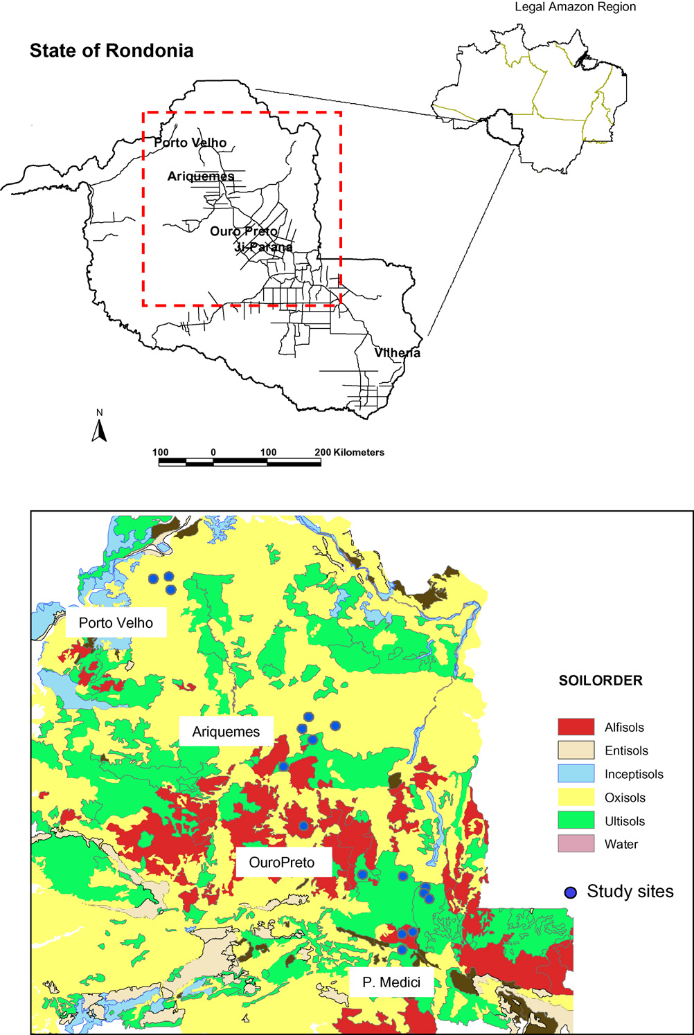
Figure 1. Map of 17 sampling sites and associated soil orders. Note that exact coordinates are not provided for the sampling locations per investigator agreements with the Rondonian landowners.
Data Citation:
Cite this data set as follows:
Numata, I.,O.A. Chadwick, D.A. Roberts, J.Schimel, F. Sampaio, F.C. Leonidas, and J.V. Soares. 2012. LBA-ECO ND-01 Forest and Pasture Soil and Grass Analyses, Rondonia, Brazil: 2003-2004. Data set. Available on-line [http://daac.ornl.gov] from Oak Ridge National Laboratory Distributed Active Archive Center, Oak Ridge, Tennessee, U.S.A. http://dx.doi.org/10.3334/ORNLDAAC/1135
Implementation of the LBA Data and Publication Policy by Data Users:
The LBA Data and Publication Policy [http://daac.ornl.gov/LBA/lba_data_policy.html] is in effect for a period of five (5) years from the date of archiving and should be followed by data users who have obtained LBA data sets from the ORNL DAAC. Users who download LBA data in the five years after data have been archived must contact the investigators who collected the data, per provisions 6 and 7 in the Policy.
This data set was archived in October of 2012. Users who download the data between October 2012 and September 2017 must comply with the LBA Data and Publication Policy.
Data users should use the Investigator contact information in this document to communicate with the data provider. Alternatively, the LBA website [http://lba.inpa.gov.br/lba/] in Brazil will have current contact information.
Data users should use the Data Set Citation and other applicable references provided in this document to acknowledge use of the data.
Table of Contents:
- 1 Data Set Overview
- 2 Data Characteristics
- 3 Applications and Derivation
- 4 Quality Assessment
- 5 Acquisition Materials and Methods
- 6 Data Access
- 7 References
1. Data Set Overview:
Project: LBA (Large-Scale Biosphere-Atmosphere Experiment in the Amazon)
Activity: LBA-ECO
LBA Science Component: Nutrient Dynamics
Team ID: ND-01 (Roberts / Barreto / Soares)
The investigators were Barreto, Paulo Goncalves; Roberts, Dar A.; Soares, Joao Vianei; Biggs, Trent W; Brandao Jr., Amintas de Oliveira; Chadwick, Oliver A.; Holmes, Karen W.; Monteiro, Andre L.; Numata, Izaya; Nunes, Samia Serra; Powell, Rebecca Lynn; Renno, Camilo and Souza Jr., Carlos Moreira de. You may contact Numata, Izaya (izaya.numata@sdstate.edu).
LBA Data Set Inventory ID: ND01_Pasture_Nutrients
This data set provides soil physical and chemical properties, and grass nutrient measurements of samples collected from 17 pasture sites located within the state of Rondonia in the southwestern Brazilian Amazon. Soil data includes bulk density, class, texture, and measurements of carbon, phosphorus, calcium, magnesium, and potassium concentrations. Foliar data includes nitrogen, phosphorus, calcium, magnesium, and potassium concentrations.
The 17 pasture sites were cattle ranches selected within the region between Porto Velho and Presidente Medici of Rondonia. Four of the ranches with Ultisols support dairy cattle and the rest have beef cattle pastures dispersed across three soil orders: Oxisols, Ultisols, and Alfisols. Soil samples were collected in May 2003, and July through August 2003, and May 2004, which covered the late rainy season (May) and the dry season (July through August).
Grass species sampled included Brachiaria brizantha, Brachiaria decumbens, B. brizantha and Pennestum clandestinum, and represented three phenologically distinct grass materials: wet-season live grass, collected in May 2004, dry-season live grass and dry-season senesced grass, both collected between the end of July and the beginning of August 2003.
2. Data Characteristics:
Data are available in four ASCII comma separated files:
File #1: Pasture_bulk_density.csv
File #2: Pasture_soil_texture.csv
File #3: Pasture_soil_nutrients.csv
File #4: Pasture_foliar_nutrients.csv
File #1: Pasture_bulk_density.csv
| Column | Heading | Units/format | Description |
|---|---|---|---|
| 1 | Site_ID | Site identification: Sites 1-17 | |
| 2 | Soil_class | Soil classification: alf =alfisol, ox =xisol, ult =ultisol | |
| 3 | Age_class | Approximate pasture age in years: Forest indicates the control site which was located in undisturbed forest. Pasture age was determined by Landsat time series and represents the age in 2003-2004 | |
| 4 | Pasture_type | Pasture classification for beef cattle or dairy (milk) cattle | |
| 5 | Bulk_density | g/cm3 | Soil bulk density for the 0-30 cm soil layer reported in grams per cubic centimeter (g/cm3) |
Example data records:
|
Site_ID,Soil_class,Age_class,Pasture_type,Bulk_density Site3,alf,Forest,Beef,1.09 Site3,alf,Forest,Beef,1.18 ... Site15,ult,greater than 15,Beef,1.59 Site17,ult,greater than 15,Beef,1.52 ... Site14,ox,greater than 15,Beef,1.26 Site14,ox,greater than 15,Beef,1.29 |
File 2: Pasture_soil_texture.csv
| Column | Heading | Units/format | Description |
|---|---|---|---|
| 1 | Site_ID | Site identification: Sites 1-17 | |
| 2 | Soil_class | Soil classification: alf =alfisol, ox =oxisol, ult=ultisol | |
| 3 | Age_class | year | Approximate pasture age in years: Forest indicates the control site which was located in undisturbed forest. Pasture age was determined by Landsat time series and represents the age in 2003-2004 |
| 4 | Pasture_type | Pasture classification for beef cattle or dairy (milk) cattle | |
| 5 | Sand | g/kg | Concentration of soil particles in sand texture class reported in grams of sand particles per kilogram of soil (g/kg) |
| 6 | Silt | g/kg | Concentration of soil particles in silt texture class reported in grams of silt particles per kilogram of soil (g/kg) |
| 7 | Clay | g/kg | Concentration of soil particles in clay texture class reported in grams of clay particles per kilogram of soil (g/kg) |
Example data records:
|
Site_ID,Soil_class,Age_class,Pasture_type,Sand,Silt,Clay Site1,ox,Forest,Beef,332,148,520 Site1,ox,Forest,Beef,328,152,520 ... Site7,ult,greater than 15,Beef,750,110,140 Site7,ult,greater than 15,Beef,672,133,195 ... Site17,ult,greater than 15,Beef,684,116,200 Site17,ult,greater than 15,Beef,547,78,375 |
File 3: Pasture_soil_nutrients.csv
| Column | Heading | Units/format | Description |
|---|---|---|---|
| 1 | Site_ID | Site identification: Sites 1-17 | |
| 2 | Soil_class | Soil classification: alf =alfisol, ox =oxisol, ult =ultisol | |
| 3 | Pasture_type | Pasture classification for beef cattle or dairy (milk) cattle | |
| 4 | Age_class | year | Approximate pasture age in years: forest indicates the control site which was located in undisturbed forest |
| 5 | pH | Soil pH | |
| 6 | P | ppm | Available soil phosphorus concentration reported in parts per million (ppm) |
| 7 | Ca | cmol/kg | Exchangeable soil calcium concentration reported in centimoles of calcium per kilogram of soil (cmol/kg) |
| 8 | Mg | cmol/kg | Exchangeable soil magnesium concentration reported in centimoles of magnesium per kilogram of soil (cmol/kg) |
| 9 | K | cmol/kg | Exchangeable soil potassium concentration reported in centimoles of potassium per kilogram of soil (cmol/kg) |
| 10 | S | cmol/kg | Sum of soil calcium, magnesium, and potassium concentrations reported in centimoles of nutrient per kilogram of soil (cmol/kg) |
| 11 | Base_sat | % | Base saturation reported in percent calculated as S (column 10) times 100 divided by cation exchange capacity |
| 12 | C | g/kg | Soil carbon concentration reported in grams of carbon per kg of soil (g/kg) |
| missing data are indicated by -9999 | |||
Example data records:
|
Site_ID,Soil_class,Pasture_type,Age_class,pH,P,Ca ,Mg,K ,S,Base_sat,C Site2,alf,Beef,6 to 10,6.1,0.72,3.03,0.24,21.51,4.62,72.41,8.3 Site2,alf,Beef,6 to 10,5.6,2.31,3.59,0.4,24.7,6.85,59.3,18.2 ... Site7,ult,Beef,greater than 15,5,1.49,0.57,0.28,30.56,3.62,25.49,12.2 Site7,ult,Beef,greater than 15,5,2.62,1.24,0.14,26.9,3.72,44.44,9.7 ... Site4,ox,Beef,Forest,3.8,0.82,0.08,0.08,0.06,5.4,4.11,6.786543 Site4,ox,Beef,Forest,3.7,0.82,0.16,0.08,0.07,4.75,3.11,10.846868 |
File 4: Pasture_foliar_nutrients.csv
| Column | Heading | Units/format | Description |
|---|---|---|---|
| 1 | Site_ID | Site identification: Sites 1-17 | |
| 2 | Year | YYYY | Year in which samples were collected |
| 3 | Month | MM | Month in which samples were collected with January =1 and December =12 |
| 4 | Soil_class | Soil classification: alf =alfisol, ox =oxisol, ult =ultisol | |
| 5 | Age_class | year | Approximate pasture age in years. Pasture age was determined by Landsat time series and represents the age in 2003-2004 |
| 6 | Pasture_type | Pasture classification for beef cattle or dairy cattle | |
| 7 | Season | Wet or dry season. Wet season samples were collected in May 2004. Dry season samples were collected in July-August 2003 | |
| 8 | Status | Foliage status either live (green) or senesced, | |
| 9 | N | g/kg | Foliar nitrogen content reported in grams of nitrogen per kilogram of foliar tissue (g/kg) |
| 10 | P | g/kg | Foliar phosphorus content reported in grams of phosphorus per kilogram of foliar tissue (g/kg) |
| 11 | K | g/kg | Foliar potassium content reported in grams of potassium per kilogram of foliar tissue (g/kg) |
| 12 | Ca | g/kg | Foliar calcium content reported in grams of calcium per kilogram of foliar tissue (g/kg) |
| 13 | Mg | g/kg | Foliar magnesium content reported in grams of magnesium per kilogram of foliar tissue (g/kg) |
Example data records:
|
Site_ID,Year,Month,Soil_class,Age_class,Pasture_type,Season,Status,Near,Month ,P,K,Ca,Mg Site2,2004,5,alf,6 to 10,Beef,wet,live,10.28,1.74,21.6,4.25,2.17 Site2,2004,5,alf,6 to 10,Beef,wet,live,9.83,2.24,22.8,2.17,2.29 ... Site11,2003,7,ult,greater than 15,Dairy,dry,senesced,6.99,1,6,5.55,2.79 Site11,2003,7,ult,greater than 15,Dairy,dry,senesced,7.17,1.22,6.9,2.57,2.3 ... Site5,2003,7,ox,greater than 15,Beef,dry,live,6.96,0.78,19.8,1.5,1.56 Site5,2003,7,ox,greater than 15,Beef,dry,live,7.71,1,19.2,0,2.13 |
Site boundaries: (All latitude and longitude given in decimal degrees)
| Site (Region) | Westernmost Longitude | Easternmost Longitude | Northernmost Latitude | Southernmost Latitude | Geodetic Datum |
|---|---|---|---|---|---|
| Rondonia | -65 | -60 | -8 | -15 | World Geodetic System, 1984 (WGS-84) |
Time period:
- The data set covers the period 2003/05/01 to 2004/05/31.
- Temporal Resolution: May 2003 (wet season), July-August 2003 (dry season) and May 2004 (wet season)
Platform/Sensor/Parameters measured include:
- LABORATORY / ANALYSIS / SOIL CHEMISTRY
- LABORATORY / ANALYSIS / SOIL BULK DENSITY
- LABORATORY / ANALYSIS / SOIL TEXTURE
- LABORATORY / ANALYSIS / NUTRIENTS
3. Data Application and Derivation:
The data set provides soil chemical and physical properties and grass foliar nutrient of several pastures established across different soil types and different land use in Rondonia, Brazil. The data can be useful for modeling soil-plant nutrient dynamics after forest conversion in the tropics as well as developing adequate management practices for Amazonian pastures according to soil properties, as well as the lengths of land use.
4. Quality Assessment:
The data analyses were conducted according to the methods well established by EMBRAPA (see the next section). No problems regarding the data quality were reported.
5. Data Acquisition Materials and Methods:
Study site:
The samples were collected from 17 study sites located in the state of Rondonia in the southwestern Brazilian Amazon. The 17 sites were cattle ranches selected within the region between Porto Velho and Presidente Medici of Rondonia. Four of the ranches with Ultisols support dairy cattle and the rest have beef cattle pastures dispersed across three soil orders: Oxisols, Ultisols, and Alfisols. Most of the beef cattle pastures were converted directly from primary forest, while some dairy pastures had diverse land-use history such as coffee, rice and corn, before the pastures were established. Pasture size can vary from less than 20 ha to more than 5,000 ha. Note that exact coordinates are not provided for the sampling locations per investigator agreements with the Rondonian landowners.
The vegetation is upland terra firme forest that receives annual precipitation of around 2,250 mm with a well-defined dry season during July and August. The average temperature is 24 degrees C, while relative humidity varies between 80% and 85% (RADAMBRASIL, 1978). Soil orders are related to geology and topography of this region. Dystrophic Oxisols and Ultisols are found mostly over the Precambrian granitoid and meta-supracrustal rocks with predominantly flat topography in the north of the state, while Alfisols are distributed mainly in central Rondonia to the south, where they are on intrusive basic and ultrabasic rocks with gently rolling topography (EMBRAPA, 1983; CPRM,1997; Holmes et al., 2004).
The predominant grass species for beef pasture across the study sites is Brachiaria brizantha, while dairy pastures are composed of a mixture of different grass species, predominantly Brachiaria decumbens, B. brizantha and Pennestum clandestinum. The pastures had never been fertilized, and we avoided the small areas that had been treated with CaCO3 to neutralize acidity. Most of the properties were burned soon after deforestation, but have not been burned since then.
Nearby primary forest sites were sampled to provide data on the original soil properties for each soil order.
Soil Sampling
Field surveys were conducted in May, and July through August 2003, and May 2004, which covered the late rainy season (May) and the dry season (July through August).
Soil samples were collected from 0 to 30 cm depth in topographically homogeneous locations within each study site and for each pasture type. We composited three samples at each sample location to have a soil sample for analysis. In total, 220 composited soil samples were collected.
Soil analyses
Soil samples were dried at 110 degrees C for 24 hours, and passed through a 2 mm sieve. Soil chemical analyses included soil pH, available P, and exchangeable K, Ca, Mg, aluminum (Al), and calculated base saturation, according to the techniques described in EMBRAPA (1997). Most of the soil chemistry analyses were run by EMBRAPA Rio de Janeiro with some samples run by EMBRAPA Rondonia.
The Melich extractor was used to extract available P and exchangeable K. This extraction procedure utilizes 0.025N of H2SO4, and 0.05N of HCl to remove labile forms of these nutrients. Phosphorus was determined using spectrophotometry by the method molybdate blue, while exchangeable K was determined by flame photometry.
Exchangeable Ca and Mg were extracted with 1N KCl, and quantified by titration with EDTA.
Exchangeable Al was extracted with 1N KCl and quantified by titration with 0.025N NaOH.
Soil pH was measured using a standard calomel electrode pH meter.
Soil texture (clay, silt, and sand)
Soil texture was determined using sedimentation as described in Bouyoucos (1951) at the Universidade Luterano de Brasil Ji-Parana.
Soil bulk density
For soil bulk density determination, two samples were collected at 0 to 15 and 16 to 30 cm depths by using a ring with a known volume (68 cm3), and the soil samples removed were dried and weighed. Reported bulk density is the average of these two measures over 0 to 30 cm. Soil bulk density analyses were all conducted at the Universidade Luterano de Brasil Ji-Parana.
Pasture grass sampling
Pasture ages ranged from 1 year to more than 30 years and were grouped into three classes (6 to 10 years, 11 to 15 years, and more than 15 years) based on a land-use history map derived from Landsat time series data (Roberts et al., 2002). For each age class in a study site, samples were taken along a 100 m transect and were obtained from 11 pastures: 2 beef on Alfisols, 3 beef on Oxisols and 3 beef and 3 dairy on Ultisols. Aboveground grass biomass was clipped in 50 cm by 50 cm plots at a 20 m interval along transects, and there were six biomass samples for each transect. Each biomass sample was separated into live and senesced materials dried at 60 degrees C for 36 hours and weighed.
Samples represented three phenologically distinct grass materials: wet-season live grass, collected in May 2004, dry-season live grass and dry-season senesced grass, both collected between the end of July and the beginning of August 2003.
Foliar chemical analyses
Dried live and senesced materials were analyzed. Total N was extracted using a modified Kjeldhal method.
Foliar total P was measured by colorimetric determination after hot-acid digestion.
Base cations (Ca, Mg, and K) were determined using an atomic absorption spectrophotometer. All foliar analyses were run at EMBRAPA Rondonia.
6. Data Access:
This data is available through the Oak Ridge National Laboratory (ORNL) Distributed Active Archive Center (DAAC).
Data Archive Center:
Contact for Data Center Access Information:
E-mail: uso@daac.ornl.gov
Telephone: +1 (865) 241-3952
References
Bouyoucos, G.J.A., 1951. Recalibration of the hydrometer method for making analysis of soils. Agron. J. 43, 434-437.
CPRM, 1997. Mapa Geologico do Estado de Rondonia. Porto Velho, RO.
EMBRAPA. 1983. Mapa de levantamento de reconhecimento de meia intensidade dos solos do estado de Rondonia, 1:500.000. Comissao Estadual de Planejamento Agrola, Porto Velho.
Holmes, K.W., Roberts, D.A., Sweeney, S., Numata, I., Matricardi, E., Biggs, T.W., Batista, G.T., Chadwick, O.A., 2004. Soil databases and the problem of establishing regional biogeochemical trends. Global Change Biol. 10, 796-814.
IBGE, 2002. Censo agropecuario de 1995-996, Instituto Brasileiro de Geografia e Estatistica. IDARON, 2004. Relatiorio: Informe semetral de campo referente a 16a etapa de vacianacao contra febre aftosa em Rondonia. IDARON, Porto Velho.
Pedlowski, M.A., Dale, D.H., Matricardi, E.A.T., Filho, E.P.S., 1997. Patterns and impacts of deforestation in Rondonia, Brazil. Landsc. Urban Plann. 38, 149-157.
RADAMBRASIL, editor 1978. Folha SC 20 Porto Velho: geologia, geomorfologia, pedologia, vegetacao e uso potencial da terra.
Roberts, D.A., Numata, I., Holmes, K., Batista, G., Krug, T., Monteiro, A., Powell, B., Chadwick, O.A., 2002. Large area mapping of land-cover change in Rondonia using multitemporal spectral mixture analysis and decision tree classifiers. J.Geophys.Res.—Atmos. 107 (D20), 1–18LBA.
Related Publications
- Numata,I. O.A. Chadwick, D.A. Roberts, J.P. Schimel, F.F. Sampaio, F.C. Leonidas, J.V. Soares. 2007. Temporal nutrient variation in soil and vegetation of post-forest pastures as a function of soil order, pasture age, and management, Rondonia, Brazil Agriculture, Ecosystems and Environment 118: 159-172.