Get Data
Summary
Satellite fire detection was determined from two sensors,—the Advanced Very High Resolution Radiometer (AVHRR) on NOAA-12 and the Moderate Resolution Imaging Spectroradiometer (MODIS) on both the Terra and Aqua platforms, for 2001- 2003 to characterize fire activity in Brazil, giving special emphasis to the Amazon region.
- Active fire data for AVHRR/NOAA-12 was produced using a fixed threshold fire detection technique based on the algorithm developed by the Centro de Previsao do Tempo e Estudos Climaticos (CPTEC/INPE) (Setzer and Pereira, 1991; Setzer et al., 1994; Setzer and Malingreau, 1996).
- Active fire data for MODIS/Terra and MODIS/Aqua was produced using a contextual fire detection technique based on NASA-University of Maryland algorithm (Justice et al., 2003; Giglio et al.2003).
Resulting fire counts were compared for major biomes of Brazil (Figure 1), the nine states of the Legal Amazon (e.g., Tocantins, Figure 2), and two important road corridors in the Amazon region (Figure 3). In evaluating the daily fire counts, there is a dependence on variations in satellite viewing geometry, overpass time, atmospheric conditions, and fire characteristics (Schroeder et al., 2005).
The data provided are the coordinates of daily active vegetation fires in Brazil for 2001 through 2003 at 1 km resolution for both AVHRR and MODIS sensors. Data are provided in both Arcview (shape file format) and ASCII comma separated (csv) file formats. Vector files for the major biomes of Brazil, the nine states of the Legal Amazon, and three important road corridors in the Amazon region are also included.
The major biomes of Brazil identified in this data set are cross-referenced to classifications and descriptions from other sources in the companion file, Brazilian Biome Classifications and Descriptions.
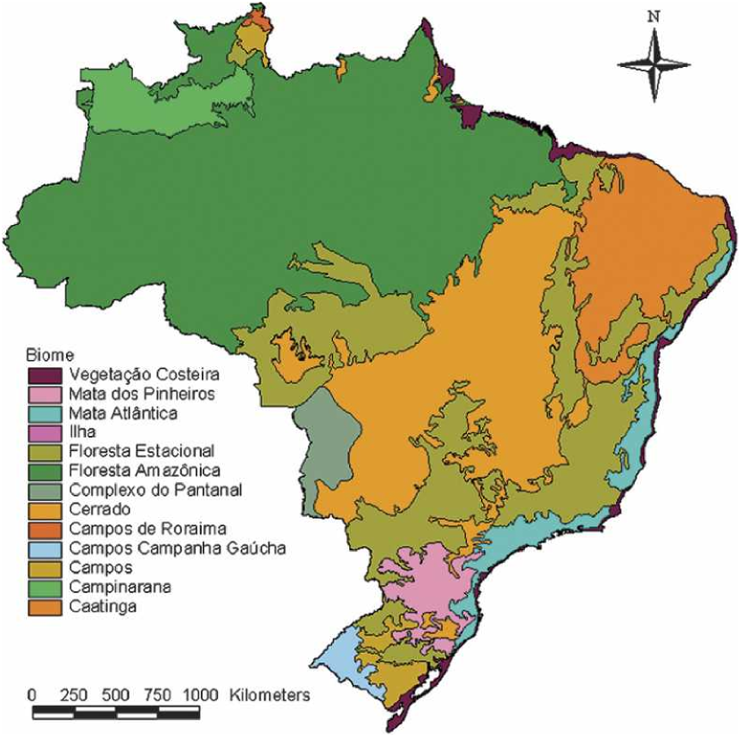
Figure 1. General biome classification map for Brazil.
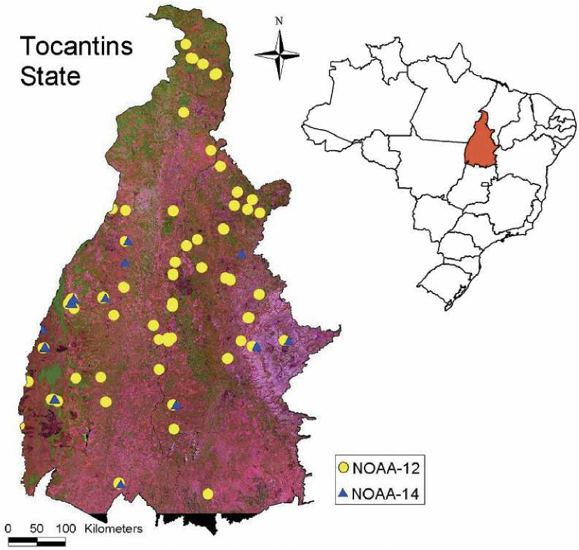
Figure 2. Hot spots detected over the state of Tocantins in Brazil on 31 Jul 2001 for N O A A - 1 2 (equator-crossing time: 2026 UTC; scan angle: 7°; hot spots: 111) and N O A A - 1 4 (equator-crossing time: 2059 UTC; scan angle: 42°; hot spots: 25), superimposed on a red–green–blue (RGB) Landsat-6 image (bands: R = 5, G = 4, B = 3).
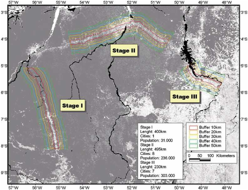
Figure 3. Case scenarios in eastern Amazon region (Pará) with typical deforestation conditions; background image corresponds to the Vegetation Continuous Field where darker areas represent higher vegetation cover; black areas correspond to water bodies.
Data Citation:
Cite this data set as follows:
Schroeder, W., J.T. Morisette, I. Csiszar, L. Giglio, D. Morton and C.O. Justice. 2007. LBA-ECO LC-23 Characterization of Vegetation Fire Dynamics for Brazil: 2001-2003. Data set. Available on-line [http://daac.ornl.gov] from Oak Ridge National Laboratory Distributed Active Archive Center, Oak Ridge, Tennessee, U.S.A., doi:10.3334/ORNLDAAC/843.
Implementation of the LBA Data and Publication Policy by Data Users:
The LBA Data and Publication Policy [http://daac.ornl.gov/LBA/lba_data_policy.html] is in effect for a period of five (5) years from the date of archiving and should be followed by data users who have obtained LBA data sets from the ORNL DAAC. Users who download LBA data in the five years after data have been archived must contact the investigators who collected the data, per provisions 6 and 7 in the Policy.
This data set was archived in August of 2007. Users who download the data between August 2007 and July 2012 must comply with the LBA Data and Publication Policy.
Data users should use the Investigator contact information in this document to communicate with the data provider. Alternatively, the LBA Web Site [http://lba.inpa.gov.br/lba/] in Brazil will have current contact information.
Data users should use the Data Set Citation and other applicable references provided in this document to acknowledge use of the data.
Table of Contents:
- 1 Data Set Overview
- 2 Data Characteristics
- 3 Applications and Derivation
- 4 Quality Assessment
- 5 Acquisition Materials and Methods
- 6 Data Access
- 7 References
1. Data Set Overview:
Project: LBA (Large-Scale Biosphere-Atmosphere Experiment in the Amazon)
Activity: LBA-ECO
LBA Science Component: Land Use and Land Cover
Team ID: LC-23 (Morisette / Schroeder / Pereira)
The investigators were Morisette, Jeffrey Thomas; Pereira, Joao Antonio Raposo; Schroeder, Wilfrid; Csiszar, Ivan Andras; Giglio, Louis and Morton, Douglas Christopher . You may contact Schroeder, Wilfrid (schroeder@hermes.geog.umd.edu).
LBA Data Set Inventory ID: LC23_Vegetation_Fire_Dynamics
Fire influences global change and tropical ecosystems through its connection to land cover dynamics, atmospheric composition, and the global carbon cycle. As such the climate change community, the Brazilian government, and the Large Scale Biosphere-Atmosphere study in Amazonia (LBA) are interested in the use of satellites to monitor and quantify fire occurrence throughout Brazil. As multiple satellite and algorithms are being utilized, it is important to quantify the accuracy of the derived products.
Related Data Sets:
LBA-ECO LC-23 Vegetation Fire Data, Roraima, Brazil: 2003.
LBA-ECO LC-23 Aster and Modis Fire Data Comparison for Brazil: 2003-2004.
2. Data Characteristics:
The daily active fire data provide coordinates of vegetation fires in Brazil at 1km resolution for both AVHRR and MODIS sensors.
All files are in shape file format and can be used in GIS software such as Arcview. The various sub-files of the shape files have been zipped so that each zip file contains data for one shape file. The shape files are in geographic projection and in WGS-84 datum.
Fire counts were assessed for major biomes of Brazil, the nine states of the Legal Amazon, and two important road corridors in the Amazon region. Vector files for these features are also included and described below.
The data provided are the coordinates of daily active vegetation fires in Brazil for 2001 through 2003 at 1km resolution for both AVHRR and MODIS sensors. Data are provided in both Arcview (shape file format) and ASCII comma separated file formats. Vector files for the major biomes of Brazil, the nine states of the Legal Amazon, and two important road corridors in the Amazon region are also included.
Active fire data available in Arcview shape file format.
File naming conventions are: satelliteplatform_year.*
Where:
satelliteplatform = aqua, noaa12, or terra
year = 2001, 2002, or 2003
and file extensions are: .dbf, .sbn, .sbx, .shp, .shx, .prj
(Arcview shape file format)
For example:
terra_2001.zip contains the following files :
terra_2001.dbf
terra_2001.sbn
terra_2001.sbx
terra_2001.shp
terra_2001.shx
terra_2001.prj
Active fire data available in comma separated ASCII format.
File naming conventions are: satelliteplatform_year.*
Where:
satelliteplatform = aqua, noaa12, or terra
year = 2001, 2002, or 2003
and file extensions are: .txt (Comma separated ASCII files)
aqua_2003.txt has the following column headings:
Latitude = latitude in decimal degrees
(+ north / - south)
Longitude = longitude in decimal degrees (+ east / - west)
Brightness = brightness temperature in Kelvin
Scan = east-west pixel size in kilometers
Track = north-south pixel size in kilometers
Acqdate = acquisition date in yyyy-mm-dd
Time = acquisition time in hhmm UTC
Satellite = satellite name A = Aqua
Confidence = detection confidence value (0.0-100.0%)
Example Data Records (aqua_2003.txt):
| Latitude,Longitude,Brightness,Scan,Track,Acqdate,Time,Satellite,Confidence
-29.4850,-49.8470,313.5000,1.7000,3.2000,2003-11-20,1630,A,0.0000 -29.4730,-49.8510,311.8000,1.7000,3.2000,2003-11-20,1630,A,0.0000 -27.2340,-48.8160,313.3000,1.6000,2.5000,2003-11-20,1630,A,64.0000 ... |
terra_yyyy.txt has the following column headings:
Latitude = latitude in decimal degrees (+ north / - south)
Longitude = longitude in decimal degrees (+ east / - west)
Brightness = brightness temperature in Kelvin
Scan = east-west pixel size in kilometers
Track = north-south pixel size in kilometers
Acqdate = acquisition date in yyyy-mm-dd
Time = acquisition time in hhmm UTC
Satellite = satellite name T = Terra
Confidence = detection confidence value (0.0-100.0%)
Example Data Record (terra_2001.txt):
| Latitude,Longitude,Brightness,Scan,Track,Acqdate,Time,Satellite,Confidence
-3.1270,-41.1000,330.4000,0.0000,0.0000,2001-09-24,1320,T,0.0000 -3.7960,-38.4800,319.8000,0.0000,0.0000,2001-09-24,1320,T,0.0000 -3.8400,-41.5190,351.4000,0.0000,0.0000,2001-09-24,1320,T,0.0000 -3.8410,-41.5100,347.0000,0.0000,0.0000,2001-09-24,1320,T,0.0000 ... |
noaa12_yyyy.txt has the following column headings:
Lat = latitude in decimal degrees (+ north / - south)
Long = longitude in decimal degrees (+ east / - west)
Date = acquisition date yyyymmdd
Time = acquisition time hhmmss UTC
Satellite = satellite name
Municipality = municipality name
State = state name (AC = Acre, AM = Amazonas, AP = Amapá, MA = Maranhao, MT = Mato Grosso, PA = Para, RO = Rondonia, RR = Roraima, TO = Tocantins)
Country = country name
Precipitation = 15 day accumulated precipitation in mm
Days_without_rain = days without rain
Fire_risk = Fire risk
Persistence = number of persistent detections
Example Data Record (noaa12_2003.txt):
| Lat,Long,Date,Time,Satellite,Municipality,State,Country,Precipitation,Days_without_rain,Fire_risk,Persistence 2.49500,-61.46000,20030101,191808,NOAA-12,MucajaÃ,RR,Brasil,25.66,7,0.462,0 0.85167,-59.50000,20030101,191808,NOAA-12,Caroebe,RR,Brasil,31.23,7,0.131,0 0.85333,-59.48667,20030101,191808,NOAA-12,Caroebe,RR,Brasil,31.23,7,0.131,0 -2.19000,-44.64167,20030101,191808,NOAA-12,Guimarães,MA,Brasil,20.67,5,0.801,0 ... |
Vector files describing physical features of study area.
Vector files defining the boundaries of the nine Brazilian Amazon states:
Produced by the Instituto Brasileiro de Geografia e Estatistica (IBGE).
Files are Arcview shape file format:
amazon_states.zip contains the following files -
amazon_states.dbf
amazon_states.shp
amazon_states.shx
amazon_states.prj
Vector files defining the boundaries of the major Brazilian ecosystems:
Produced by the Instituto Brasileiro de Meio Ambiente (IBAMA).
Files are Arcview shape file format:
ecosystem.zip contains the following files -
ecosystem.dbf
ecosystem.sbn
ecosystem.sbx
ecosystem.shp
ecosystem.shxecosystem.prj
Vector files defining buffer zones of 10km-50km along three road corridors in the Brazilian Amazon region showing different stages of development:
Filenames use the following conventions: bufferXXkm_stageY.dbf
where:
XX = the buffer distance in kilometers (10, 20, 30, 40, or 50)
Y = the Stage of development (I, II, III)
Stage I coincides with the main axis of highway BR-163.
Stages II and III coincide with the main axis of highway BR-230.Files are Arcview shape file format:
buffer10km_stageI.zip contains the following files –
buffer10km_stageI.dbf
buffer10km_stageI.sbn
buffer10km_stageI.shx
buffer10km_stageI.dbp
buffer10km_stageI.shx
buffer10km_stageI.prj
Site boundaries: (All latitude and longitude given in degrees and fractions)
| Site (Region) | Westernmost Longitude | Easternmost Longitude | Northernmost Latitude | Southernmost Latitude | Geodetic Datum |
|---|---|---|---|---|---|
| Brazil | -74 | -34.8 | 5.3 | -33.75 | World Geodetic System, 1984 (WGS-84) |
Time period:
- The data set covers the period 2001/01/01 to 2003/12/31.
- Temporal Resolution:Daily
Platform/Sensor/Parameters measured include:
- TERRA (MORNING EQUATORIAL CROSSING TIME SATELLITE) / MODIS (MODERATE-RESOLUTION IMAGING SPECTRORADIOMETER) / FIRE OCCURRENCE
- AQUA (AFTERNOON EQUATORIAL CROSSING TIME SATELLITE) / MODIS (MODERATE-RESOLUTION IMAGING SPECTRORADIOMETER) / FIRE CHARACTERISTICS
- NOAA-12 (NATIONAL OCEANIC & ATMOSPHERIC ADMINISTRATION-12) / AVHRR (ADVANCED VERY HIGH RESOLUTION RADIOMETER) / REFLECTANCE
3. Data Application and Derivation:
Active fire data for AVHRR/NOAA-12 was produced using a fixed threshold fire detection technique based on the algorithm developed by the Centro de Previsao do Tempo e Estudos Climaticos (CPTEC/INPE)(Setzer and Pereira, 1991; Setzer et al., 1994; Setzer and Malingreau, 1996). Active fire data for MODIS/Terra and MODIS/Aqua was produced using a contextual fire detection technique based on NASA-University of Maryland algorithm (Justice et al., 2003; Giglio et al.2003).
4. Quality Assessment:
MODIS active fire data quality assessment information is available in the related paper:
Schroeder, W., J.T. Morisette, I. Csiszar, L. Giglio, D. Morton, and C.O. Justice. 2005. Characterizing Vegetation Fire Dynamics in Brazil through Multisatellite Data: Common Trends and Practical Issues. Earth Interactions 9(13):1-26.
5. Data Acquisition Materials and Methods:
Raw satellite imagery used to run detection algorithms by CPTEC/INPE and NASA/UMD. AVHRR/NOAA-12 images were received and archived by the Instituto Nacional de Pesquisas Espaciais (INPE) in Brazil; MODIS images were received and archived by NASA.
Sensors used include:
- MODIS (MODERATE-RESOLUTION IMAGING SPECTRORADIOMETER)
- AVHRR (ADVANCED VERY HIGH RESOLUTION RADIOMETER)
6. Data Access:
This data is available through the Oak Ridge National Laboratory (ORNL) Distributed Active Archive Center (DAAC) or the EOS Data Gateway.
Data Archive Center:
Contact for Data Center Access Information:
E-mail: uso@daac.ornl.gov
Telephone: +1 (865) 241-3952
7. References:
Giglio, L., Descloitres, J., Justice, C. O., and Kaufman, Y., 2003, An enhanced contextual fire detection algorithm for MODIS. Remote Sensing of Environment, 47, 1311-1318.
Justice, C. O, Giglio, L., Korontzi, S., Owens, J., Morisette, J. T., Roy, D., Descloitres, J., Alleaume, S., Petitcolin, F., and Kaufman, Y., 2002, The MODIS fire products. Remote Sensing of Environment, 83, 244-262.
Morisette, Jeffrey T., Louis Giglio, Ivan Csiszar, Alberto Setzer, Wilfrid Schroeder, Douglas Morton and Christopher O. Justice. 2005: Validation of MODIS Active Fire Detection Products Derived from Two Algorithms. Earth Interactions: Vol. 9, No. 9, pp. 1–25.
Schroeder, W., J.T. Morisette, I. Csiszar, L. Giglio, D. Morton, and C.O. Justice. 2005. Characterizing Vegetation Fire Dynamics in Brazil through Multisatellite Data: Common Trends and Practical Issues. Earth Interactions 9(13):1-26.
Setzer, A. W., and Pereira, M. C., 1991, Operational detection of fires in Brazil with NOAA/AVHRR. 24th International Symposium on Remote Sensing of the Environment,Rio de Janeiro, Brazil (Ann Arbor, E.R.I.M.), 469-482.
Setzer, A.W., Pereira Jr, A.C. and Pereira, M.C., 1994, Satellite studies of biomass burning in Amazonia: some practical aspects. Remote Sensing Reviews, 10, 91-103.
Setzer, A. W., and Malingreau, J. P., 1996, AVHRR Monitoring of Vegetation Fires in the Tropics: Toward the Development of a Global Product. In Biomass Burning and Global Change, Vol. 1: Remote Sensing, Modeling and Inventory Development, and Biomass Burning in Africa, edited by J. S. Levine (MIT Press: Cambridge MA), pp. 25-39.