Summary:
This data set provides the results of two modeled scenarios for future patterns of deforestation across the Amazon Basin from 2002 to 2050. This larger defined Amazon Basin (PanAmazon area) includes the Amazon River watershed, the Legal Amazon in Brazil, and the Guiana region.
The model SimAmazonia was used to simulate monthly deforestation in the Amazon Basin from 2002 to 2050 for two scenarios: (1) a "Business-as-Usual" scenario, which considered the deforestation trends across the basin and projected the rates by using historical images and their variations from 1997 to 2002 and then added to that the effect of paving a set of major roads, and (2) a "Governance" scenario, that also considered the current deforestation trends, but assumed a 50% limit imposed for deforested land within each basin's subregion, and that existing and proposed Protected Areas (PAs), play a decisive role in limiting deforestation as well (Soares et al., 2006).
The provided data products include one GeoTiff (*.tif) for each year (2002 to 2050) for both model scenarios for a total of 98 files. The files have been compressed in two *.zip files, one for each model scenario. There is also one comma-delimited file that contains the model input data derived from satellite deforestation maps.
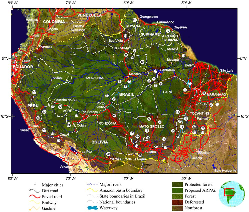
Figure 1. Amazon Basin, its major cities, paved and major dirt roads, and existing and proposed protected areas. The larger Amazon Basin includes the Amazon River watershed, the Legal Amazon in Brazil, and the Guiana region (From Soares et al. 2006, Supplementary material).
Data Citation:
Cite this data set as follows:
Soares-Filho B.S., D.C. Nepstad, L.M. Curran, E. Voll, G.C. Cerqueira, R.A. Garcia, C.A. Ramos, A. McDonald, P. Lefebvre, and P. Schlesinger. 2013.LBA-ECO LC-14 Modeled Deforestation Scenarios, Amazon Basin: 2002-2050. Data set. Available on-line (http:daac.ornl.gov) from Oak Ridge National Laboratory Distributed Active Archive Center, Oak Ridge, Tennessee, U.S.A. http://dx.doi.org/10.3334/ORNLDAAC/1153
Implementation of the LBA Data and Publication Policy by Data Users:
The LBA Data and Publication Policy [http://daac.ornl.gov/LBA/lba_data_policy.html] is in effect for a period of five (5) years from the date of archiving and should be followed by data users who have obtained LBA data sets from the ORNL DAAC. Users who download LBA data in the five years after data have been archived must contact the investigators who collected the data, per provisions 6 and 7 in the Policy.
This data set was archived in April 2013. Users who download the data between April 2013 and March 2018 must comply with the LBA Data and Publication Policy.
Data users should use the investigator contact information in this document to communicate with the data provider.
Data users should use the Data Set Citation and other applicable references provided in this document to acknowledge use of the data.
Table of Contents:
- 1 Data Set Overview
- 2 Data Characteristics
- 3 Applications and Derivation
- 4 Quality Assessment
- 5 Acquisition Materials and Methods
- 6 Data Access
- 7 References
1. Data Set Overview:
Project: LBA (Large-Scale Biosphere-Atmosphere Experiment in the Amazon)
Activity: Amazon Scenarios Program
LBA Science Component: Land Use and Land Cover
Team ID: LC-14 (Nepstad / Moutinho)
The investigators were Nepstad, Daniel Curtis; Moutinho, Paulo Roberto de Souza; Andrade, Sergio Viana de; Arce, Javier Alberto; Asner, Gregory Paul; Belk, Elizabeth Leslie; Brando, Paulo Monteiro; Breyer, Lace Medeiros; Cardinot, Gina Knust; Carvalho Jr., Oswaldo de; Costa, Luciana Miranda; Silva, Wanderley Rocha da; Dias-Filho, Moacyr Bernardino; Figueiredo, Ricardo de Oliveira; Guerrero, Jose Benito; Holbrook, Noel Michele; Kingerlee, Wendy; Klink, Carlos Augusto; Lameira, Wanja Janayna Miranda; Lefebvre, Paul A.; Maklouf, Eduardo Jorge; Markewitz, Daniel; Miranda, Heloisa S.; Monaco, Luciana Magalhaes; Morton, Douglas C.; Oliveira, Rafael Silva; Peters, Charles Merideth; Pinto, Flavia dos Santos; Ray, David G.; Santos, Alexandre Barbosa; Schlesinger, Peter; Schwalbe, Karen R.; Silva, Dulce Alves da; Solorzano, Luis Anibal Cardenas; Sternberg, Leonel and Steward, Corrina Dawn . You may contact Nepstad, Daniel Curtis (dnepstad@whrc.org); Paul Lefebvre (paul@whrc.org) and Schlesinger, Peter (pschles@whrc.org).
LBA Data Set Inventory ID: LC14_Amazon_Scenarios
This data set provides the results of two modeled scenarios for future patterns of deforestation across the Amazon Basin from 2002 to 2050. This larger defined Amazon Basin (PanAmazon area) includes the Amazon River watershed, the Legal Amazon in Brazil, and the Guiana region.
The model SimAmazonia was used to simulate monthly deforestation in the Amazon Basin from 2002 to 2050 for two scenarios: (1) a "Business-as-Usual" scenario, which considered the deforestation trends across the basin and projected the rates by using historical images and their variations from 1997 to 2002 and then added to that the effect of paving a set of major roads, and (2) a "Governance" scenario, that also considered the current deforestation trends, but assumed a 50% limit imposed for deforested land within each basin's subregion, and that existing and proposed Protected Areas (PAs), play a decisive role in limiting deforestation as well (Soares et al., 2006).
2. Data Characteristics:
This data set includes the following files:
Ninety-eight data files in GeoTiff format compressed in two *.zip files. One *.zip file includes GeoTiffs resulting from the “Business-as-Usual” model scenario. The second *.zip file includes GeoTiffs resulting from the “Governance” model scenario.
One comma-delimited file Amazon_Scenarios_Input_Data.csv, which provides model input data derived from satellite deforestation maps.
Image File Characteristics
- Spatial resolution: 1-km2
- Geographic Coordinate System: GCS_WGS_1984
- Datum: World Geodetic System, 1984 (WGS-84)
The images include the following values:
| Value | Description |
|---|---|
| 1 | deforested |
| 2 | forest |
| 3 | non-forest |
| 0 | No data |
File-naming convention: the files are named according to the simulation scenario_yyyy.tif,
where simulation scenario is Business_as_Usual or Governance, and yyyy is the year (2002 to 2050):
Example file names:
Business_as_Usual_2002.tif
Governance_2050.tif
Comma-delimited, model input data file derived from satellite deforestation maps:
Amazon_Scenarios_Input_Data.csv
| Column | Heading | Units/format | Description |
|---|---|---|---|
| 1 | Country | Country | |
| 2 | Subregion | Subregion (1 - 47) | |
| 3 | Total_area | km2 | Total area in square kilometers (km2) |
| 4 | Forest_2001 | km2 | Forested area in square kilometers (km2) in 2001 |
| 5 | Deforested_2001 | km2 | Deforested area in square kilometers (km2) in 2001 |
| 6 | Nonforest_2001 | km2 | Nonforested area in square kilometers (km2) in 2001 |
| 7 | Gross_def_2001 | km2 | Gross deforestation in square kilometers (km2) in 2001 |
| 8 | Net_def_2001 | percent | Net deforestation in 2001 provided as percent |
| 9 | Annual_derivative | percent | Annual derivative: an average calculated from the difference
between 1997-2000, 2000-2001, and 2001-2002 annual deforestation rates provided as percent |
| 10 | Protected_forest | km2 | Area in protected forest in square kilometers (km2) |
| 11 | Protected_and_ARPAS | km2 | Area in protected forest + ARPAS in square kilometers (km2) |
| Areas in km2, annual derivative is an average calculated from the difference between 1997-2000, 2000-2001, and 2001-2002 annual deforestation rates. | |||
Example data records:
|
Country,Subregion,Total_area,Forest_2001,Deforested_2001,Nonforest_2001, Gross_def_2001,Net_def_2001,Annual_derivative,Protected_forest,Protected_and_ARPAS Brazil,1,43775,30768,10780,2227, 515,1.67%,5.44%,1166,22326 Brazil,2,207144,189637,8788,8719, 274,0.14%,15.71%,107922,167687 Brazil,3,56179,2756,21117,32306, 383,13.89%,2.21%,304,335 ... Venezuela,34,184265,160130,12776,11359, 553,0.35%,2.24%,57165,57165 Ecuador,35,116947,94745,8540,13663, 388,0.41%,2.96%,22513,22513 Guyana,36,215409,182233,7390,25786, 210,0.12%,2.24%,6035,6235 ... Bolivia,44,235287,127955,30187,77144, 1077,0.84%,2.31%,14781,14781 Colombia,45,240938,231848,511,8579, 292,0.13%,0.40%,95478,95478 Colombia,46,204147,158658,28791,16698, 650,0.41%,2.96%,44205,44205 |
Site boundaries: (All latitude and longitude given in decimal degrees)
| Site (Region) | Westernmost Longitude | Easternmost Longitude | Northernmost Latitude | Southernmost Latitude | Geodetic Datum |
|---|---|---|---|---|---|
| Amazon Basin | -81.86 | -34.29 | 12.98 | -55.77 | World Geodetic System, 1984 (WGS-84) |
Time period:
- The data set covers the period 2002/01/01 to 2050/12/31
- Temporal Resolution: Not applicable
Platform/Sensor/Parameters measured include:
- COMPUTER MODEL / MODEL ANALYSIS / LAND COVER
- COMPUTER MODEL / MODEL ANALYSIS / DEFORESTATION
3. Data Application and Derivation:
Typical Application of Data:
The simulated patterns of deforestation can be employed in regional-
national- and sub-national-level forest and land use change assessments
to evaluate future environmental impacts, such as habitat
fragmentation, biodiversity loss, and hydrologic cycle alteration, to
produce base lines of carbon emission, and used as inputs for global
climate models.
4. Quality Assessment:
Not available.
5. Data Acquisition Materials and Methods:
Model Description
The model SimAmazonia was used to simulate two deforestation scenarios across the Amazon Basin for the years 2002 to 2050:
1. The "Business-as-Usual" scenario considered the deforestation trends across the basin and projected the rates by using historical figures and their variations from 1997 to 2002, then added to them the effect of paving a set of major roads. In this scenario, the paving follows a predefined schedule and its effect on deforestation is empirically estimated using data from the Amazon Deforestation Monitoring Project, Projeto de Monitoramento do Desflorestamento na Amazônia Legal (PRODES), analyzed at the municipality level.
2. The "Governance" scenario also considered the current deforestation trends, but assumed an asymptotic logistic curve. In this scenario, a 50% limit is imposed for deforested land within each basin's subregion, and existing and proposed PAs play a decisive role in restricting deforestation as well.
The SimAmazonia architecture consists of coupled models structured in two spatial levels: (1) 47 socioeconomic subregions that were defined according to the potential for deforestation based on socioeconomic and demographic growth and (2) raster cells.
Each subregion had customized parameters with individualized forecasts of deforestation rates estimated from historical trends (from 1997 to 2002) derived from satellite-based deforestation maps, the planned road paving schedule and existing and proposed PAs. (For a detailed discussion of the stratification process, refer to Soares et al., 2006.)
Cartographic algebra and cellular automata techniques were used to develop the spatially explicit simulation that comprised a map of 3,144 by 4,238 cells at a 1 km2 resolution. The model employs cartographic data on infrastructure, administrative units, and biophysical settings, and was spatially calibrated for 12 case-study regions in the Brazilian Amazon (Soares et al., 2006).
Model Inputs
Several data sources were used in the simulations. The data file Amazon_Scenarios_Input_Data.csv provides model input data derived from satellite deforestation maps and is included with this data set.
Additional data sources not provided with this data set but described in the supplementary section of Soares et al., (2006) include the following:
- A land cover map for the entire basin, used as the initial landscape in the simulation, was a composite of the 2001 PRODES, 2000 SPOT Vegetation Map of South America, classified 2001 MODIS vegetation continuous field, and 1993 Bolivia deforestation map. This map is not included with this data set.
- A non-forest mask obtained from vegetation maps (laid over the land cover map composite). This mask is not included with this data set.
- Several sources of cartographic data.
- PRODES data from three time periods (1997-2000, 2000-2001, 2001-2002), employed to derive the 2001- 2002 deforestation rates and their average annual derivatives within the 1997-2002 period.
The data were assembled by The Woods Hole Research Center in collaboration with the following institutions: Instituto de Pesquisa Ambiental da Amazonia (Amazonian Institute for Environmental Research, IPAM), Conservation International, and Instituto Nacional de Pesquisas Espaciais (National Institute of Space Research, INPE), using their own data, and contributions by many other organizations.
Model Outputs
The data products with this data set include one GeoTiff (*.tif) for each year (2002 to 2050) for both model scenarios for a total of 98 files.
6. Data Access:
This data is available through the Oak Ridge National Laboratory (ORNL) Distributed Active Archive Center (DAAC).
Data Archive Center:
Contact for Data Center Access Information:
E-mail: uso@daac.ornl.gov
Telephone: +1 (865) 241-3952
7. References:
Soares, B.S., Nepstad, D.C., Curran, L.M., Cerqueira, G.C., Garcia, R.A., Ramos, C.A., Voll, E., McDonald, A., Lefebvre, P. & Schlesinger, P. 2006. Modelling conservation in the Amazon basin. Nature 440, 520-523.
Related Publications:
- Nepstad, D.C., G. Carvalho, A.C. Barros, A. Alencar, J.P. Capobianco, J. Bishop, P. Moutinho, P. Lefebvre, U.L. Silva, and E. Prins. 2001. Road paving, fire regime feedbacks, and the future of Amazon forests. Forest Ecology and Management 154(3):395-407.