Documentation Revision Date: 2017-08-17
Data Set Version: 1
Summary
The integrated database of diverse environmental resource information from extant sources was developed by the Environmental Sciences Division at Oak Ridge National Laboratory (Olson et al. 1980). Some data sets described in Olson et al. 1980 are no longer available. County data sets have Federal Information Processing Standards (FIPS) numeric state and county codes that allow merging of the separate files. Some files, such as species dictionaries or point data, do not have FIPS identifiers. Data are stored in metric-SI units. For more detailed descriptions of the Geoecology database contents, users may refer to the Geoecology Technical Memorandum, provided here as Geoecology_TM.pdf. It serves as both documentation and a user's guide to the Geoecology database, giving general information on the data set contents, sources of data, and specific variable descriptions.
The Geoecology database is comprised of 61 individual data files in tab-delimited text file format (*.txt), 46 of which are also provided as shapefiles (*.shp compressed in *.zip format). Shapefile data are also provided as companion files in KMZ format for visualization in Google Earth.

Figure 1. Data set C14: Monthly average precipitation by state climatic division 1941-1970
Citation
Olson, R.J., C.J. Emerson, and M.K. Nungesser. 2017. Geoecology: County-Level Environmental Data for the United States, 1941-1981. ORNL DAAC, Oak Ridge, Tennessee, USA. https://doi.org/10.3334/ORNLDAAC/656
Table of Contents
- Data Set Overview
- Data Characteristics
- Application and Derivation
- Quality Assessment
- Data Acquisition, Materials, and Methods
- Data Access
- References
- Data Set Revisions
Data Set Overview
The Geoecology database is a compilation of environmental data for conterminous US for the period 1941 to 1981. The Geoecology database contains selected data on terrain and soils, water resources, forestry, vegetation, agriculture, land use, wildlife, air quality, climate, natural areas, and endangered species. Data on selected human population characteristics are also included to complement the environmental files. Data represent the conterminous United States at the county level. These historical data are provided as a source of 1970s baseline environmental conditions for the United States.
Revision Note: This data set has been updated to also provide shapefiles and corresponding *.kmz files created from the original (*.txt) county-level data tables. Note that no changes have been made to the data values.
The integrated database of diverse environmental resource information from extant sources was developed by the Environmental Sciences Division at Oak Ridge National Laboratory (Olson et al. 1980). Some data sets described in Olson et al. 1980 are no longer available. County data sets have Federal Information Processing Standards (FIPS) numeric state and county codes that allow merging of the separate files. Some files, such as species dictionaries or point data, do not have FIPS identifiers. Data are stored in metric-SI units. For more detailed descriptions of the Geoecology database contents, users may refer to the Geoecology Technical Memorandum, provided here as Geoecology_TM.pdf. It serves as both documentation and a user's guide to the Geoecology database, giving general information on the data set contents, sources of data, and specific variable descriptions.
Data Characteristics
Spatial Coverage: United States
Spatial Resolution: County-level; state-level
Temporal Coverage: 1941-1981
Temporal Resolution: Single observation; monthly; annual
Study Area: (all latitudes and longitudes given in decimal degrees)
| Site | Westernmost Longitude | Easternmost Longitude | Northernmost Latitude | Southernmost Latitude |
|---|---|---|---|---|
| United States | -124.762578 | -66.949894 | 49.384366 | 24.498135 |
Data File Information
There are 107 data files and 52 companion files included in this data set.
Of the 107 data files:
- 61 are tables in tab-delimited text (*.txt) file format (original files)
- 46 are shapefiles (*.shp files compressed into *.zip archives) created from the original data files
Of the 52 companion files:
- 46 are compressed Keyhole Markup Language (*.kmz) format files made from the corresponding shapefiles, for viewing in Google Earth.
- Five are additional tables containing coded variable definitions and other ancillary information in text file format (original files).
- Specifically, G01.txt, provides a list of data set titles and characteristics in tabular format, and
- G02.txt, provides a list of data table variables and definitions.
- The Geoecology Technical Memorandum, Geoecology_TM.pdf, provides general information about each of the data tables.
Please note that if a data table described in Olson et al. 1980 is listed in the documentation below, the data set is no longer available. Data sets with no Geoecology_TM.pdf page number in the tables below are not referenced in the technical memorandum and users should refer to companion files G01.txt and G02.txt for additional information.
Data processing notes regarding converting the *.txt data tables to shapefiles:
State and county-level data sets with multiple records per unique FIPS state and county code were merged to a single row in the corresponding shapefiles. For example:
D06.txt
| FIPS_ST | FIPS_CO | VEG_CODE |
|---|---|---|
| 06 | 001 | 029 |
| 06 | 001 | 040 |
| 06 | 001 | 042 |
D06.shp
| FIPS_ST | FIPS_CO | VEG_CODE1 | VEG_CODE2 | VEG_CODE3 |
|---|---|---|---|---|
| 06 | 001 | 029 | 040 | 042 |
Spatial Reference Information
GCS_WGS_1984
WKID: 4326 Authority: EPSG
Angular Unit: Degree (0.0174532925199433)
Prime Meridian: Greenwich (0.0)
Datum: D_WGS_1984
Spheroid: WGS_1984
Semimajor Axis: 6378137.0
Semiminor Axis: 6356752.314245179
Inverse Flattening: 298.257223563
Data Tables
Files are categorized and named by sector as identified in companion files Geoecology_TM.pdf and G01.txt
- Sixteen of the original tables were not converted to shapefiles because they do not have a spatial component. These tables can be identified as those without a Geographic Unit in the sector tables below.
- Five files (D11.txt, G01.txt, G02.txt, T07.txt, and T15.txt) are now distributed as companion files because they are description tables.
Agriculture
Agricultural data sets included in the Geoecology database are listed in the table below. These data sets provide both crop and livestock data for counties based on state and federal inventories.
| File | Contents | Year | Geographic Unit | Geoecology_TM.pdf page(s) |
|---|---|---|---|---|
| A01 | Crop areas and yields, agriculture land use | 1978 | County | 16 |
| A04 | Crop planted/harvested areas and yields | 1975 | County | 20 |
| A05 | Index of Crop Reporting Districts | 1975 | County | 21 |
Data set A04.txt and the corresponding shapefile (A04.shp) provide statistics for U.S. counties for major crops in 1975 obtained from the Economics, Statistics, and Cooperative Services (ESCS), USDA. Variables, variable descriptions, and units for A04.txt are detailed in Table 1. Crop details for each county were merged to a single row for inclusion in A04.shp: ..., CORN_YEAR, CORN_PLN, CORN_HRV, CORN_PRD, CORN_YLD, PEANUTS_YEAR, etc.
Table 1. Variables, variable descriptions, and units for A04.txt
| Variable | Description | Units |
|---|---|---|
| FIPS_ST | FIPS state code | |
| FIPS_CO | FIPS county code | |
| CROP | Crop name | |
| YEAR | Year of ESCS estimate | |
| CROP_PLN | Planted area | ha |
| CROP_HRV | Harvested area | ha |
| CROP_PRD | Production | kg |
| CROP_YLD | Yield | kg/ha |
Base Data
| File | Contents | Year | Geographic Unit | Geoecology_TM.pdf page(s) |
|---|---|---|---|---|
| B01 | County codes, names, and centroids | 1970 | County | 23 |
| B02 | State names and indices (EPA, BBS, NOAA) | 1970 | State | 24 |
| B06 | Air (ACQR) and Water (WRC-SA) Indices | 1975 | County | 25 |
| B08 * | General regional indices | 1970-1975 | County | 27,28 |
* Note: B08 data is described under "003" in the Climate section of the Geoecology technical memorandum.
Climate
Climatic data sets included in the Geoecology database for county-subcounty units and State Climatic Divisions (SCDs) are listed in the table below. The SCD shapefile template to which the tabular data files were merged was obtained from NOAA's National Climatic Data Center website.
| File | Contents | Year | Geographic Unit | Geoecology_TM.pdf page(s) |
|---|---|---|---|---|
| C07 | Monthly average temperatures by county | 1941-1970 | County | 29 |
| C08 | Monthly average precipitation by county | 1941-1970 | County | 30 |
| C09 | Monthly potential evaporation by county | 1941-1970 | County | 31 |
| C10 | Monthly moisture index by county | 1941-1970 | County | 32, 33 |
| C11 | Monthly average temperatures by division | 1941-1970 | SCD | 34 |
| C12 | Monthly maximum temperatures by division | 1941-1970 | SCD | 35 |
| C13 | Monthly minimum temperatures by division | 1941-1970 | SCD | 36 |
| C14 | Monthly average precipitation by division | 1941-1970 | SCD | 37 |
| C15 | Monthly maximum precipitation by division | 1941-1970 | SCD | |
| C16 | Monthly minimum precipitation by division | 1941-1970 | SCD | 38 |
| C17 | Climatic division index | 1970 | County | 39 |
| C18 | Growing season length, first/last frost | 1978 | County | 40 |
| C19 | State climatic division names/weights | 1975 | SCD | 41 |
| C20 | Rainfall pH and H-ion loadings | 1974 | County | 42 |
| C21 | Inversion day probabilities | County |
Vegetation
The vegetation data sets provide national and county-level statistics of natural vegetation coverage for ecoregions (Bailey 1976, Bailey 1978). County-level data sets with multiple records per unique FIPS state and county code (D06, D08, D10, D13) were merged to a single row in the corresponding shapefiles.
| File | Contents | Year | Geographic Unit | Geoecology_TM.pdf page(s) |
|---|---|---|---|---|
| D03 | Potential and land use-adjusted vegetation national statistics | 1966-1967 | 44, 45 | |
| D04 | Potential and land use-adjusted vegetation by county | 1966-1967 | County | 46, 47 |
| D05 | Vegetation/land use change probabilities | 1978 | 48 | |
| D06 | Vegetation replacement by urban areas by county | 1978 | County | 49 |
| D07 | Summary statistics (D08) for potential and land use-adjusted ecoregions | 1976 | 50 | |
| D08 | Potential and land use-adjusted areas for ecoregions by county | 1976 | County | 51 |
| D09 | Potential and land use adjusted vegetation statistics for ecoregions | 1978 | 52 | |
| D10 | Potential and land use-adjusted vegetation statistics for ecoregions by county | 1978 | County | 53 |
| D13 | Vegetation sensitivity to sulfur dioxide (SO2) | 1979 | County | 54 |
The vegetation data includes one companion file (D11.txt) providing ecoregion code definitions.
Energy
The energy data set (E04) lists power generating facilities by county.
| File | Contents | Year | Geographic Unit | Geoecology_TM.pdf page(s) |
|---|---|---|---|---|
| E04 | Generating utility reference file | 1981 |
Forestry
The forestry data set (F08) provides forest area, volume, and growth statistics for hardwood and softwood forests at the county-level from data sets F01-07 (not included; see Geoecology technical memorandum).
| File | Contents | Year | Geographic Unit | Geoecology_TM.pdf page(s) |
|---|---|---|---|---|
| F08 | Forest area, volume, and growth | 1965-1980 | County |
Data set F08.txt and the corresponding shapefile (F08.shp) are not described in the Geoecology technical memorandum or companion files G01.txt and G02.txt. Variables, variable descriptions, and units are listed in Table 2.
Table 2. Variables, variable descriptions, and units for F08.txt and F08.shp
| Variable | Description | Units |
|---|---|---|
| YEAR | CFI observation year | |
| FIPS_ST | FIPS state code | |
| FIPS_CO | FIPS county code | |
| FS_HWD_G | Hardwood growing stock volume | m3/ha |
| FS_HWD_V | Hardwood volume in commercial forest | m3/ha |
| FS_LND_A | Land area | ha |
| FS_SWD_G | Softwood growing stock volume | m3/ha |
| FS_SWD_V | Softwood volume in commercial forest | m3/ha |
| FS_TOT_A | Total forested area | ha |
| FS_TOT_G | Total growing stock volume | m3/ha |
| FS_TOT_V | Total volume in commercial forest | m3/ha |
Air Quality
The air quality data set (K04) provides county-level air quality compliance with standards set forth by the Clean Air Act and other legislation.
| File | Contents | Year | Geographic Unit | Geoecology_TM.pdf page(s) |
|---|---|---|---|---|
| K04 | Air quality non-attainment areas (EPA) | 1979 | County | 66 |
Land
Land data sets provide county-level land use statistics from the 1967 Conservation Needs Inventory (USDA 1971).
| File | Contents | Year | Geographic Unit | Geoecology_TM.pdf page(s) |
|---|---|---|---|---|
| L01 | Land use statistics (CNI detailed) | 1967 | County | 68,69 |
| L02 | Land capability classes (CNI) | 1967 | County | 70,71 |
| L05 | Land surface mining | 1975 | County | 72 |
| L06 | Land resource region index | 1967 | County | 73 |
| L07 | Land use (CNI aggregated) | 1967 | County | 74 |
| L08 | Land areas (rural, urban, roads, water, fed) | 1979 | County | 75,76 |
Minerals
Minerals data sets provide county-level summaries of coal production and reserves.
| File | Contents | Year | Geographic Unit | Geoecology_TM.pdf page(s) |
|---|---|---|---|---|
| M03 | Coal reserves characteristics | 1977 | County | |
| M04 | Coal production with projections | 1975 | County |
Natural Areas
Natural areas data sets list areas administered and protected to maintain natural ecological conditions including parks, wilderness areas, national forests and rangeland, wildlife refuges, ecological preserves, etc.
| File | Contents | Year | Geographic Unit | Geoecology_TM.pdf page(s) |
|---|---|---|---|---|
| N01 | Rare II tracts | 1978 | Points | 78 |
| N02 | National Park Service areas | 1979 | County | 79 |
| N03 | Wilderness areas | 1978 | County | 80 |
| N04 | Rare II tracts by county | 1978 | ||
| N05 | Rare II tracts by ecoregion and vegetation | 1978 | ||
| N06 | Rare II tracts ORNL ranks | 1979 | ||
| N07 | Rare II tracts USFS data | 1978 | ||
| N17 | National forest areas | 1980 | County | |
| N18 | National wildlife refuges | 1980 | County |
Population
Population data sets provide county-level population and housing statistics.
| File | Contents | Year | Geographic Unit | Geoecology_TM.pdf page(s) |
|---|---|---|---|---|
| P01 | Population by sex and 5-year age class | 1970 | County | 81, 82 |
| P03 | Population and housing | 1980 | County |
Terrain
Terrain data sets provide soil characteristics such as moisture and organic matter content, temperature, and texture at the county level.
| File | Contents | Year | Geographic Unit | Geoecology_TM.pdf page(s) |
|---|---|---|---|---|
| T03 | Soils at map unit level | 1967 | County | 84 |
| T08 | Great soil groups characteristics | 1967 | 92 | |
| T09 | Great soil groups within map units | 1967 | 93 | |
| T13 | Soils at soil order level | 1967 | County | 97 |
| T14 | Physical regions | 1970 | County |
Terrain data includes two companion files (T07.txt and T15.txt) providing soil map code and physical region code dictionaries.
Wildlife
Wildlife data sets list endangered species by county (W10) and for the U.S. (W09).
| File | Contents | Year | Geographic Unit | Geoecology_TM.pdf page(s) |
|---|---|---|---|---|
| W09 | Endangered species codes dictionary | 1977 | 102 | |
| W10 | Endangered species (BNL file) | 1977 | County | 103 |
Companion File Information
Companion files are provided in tab-delimited text (*.txt) file format and contain coded variable definitions and other ancillary information. The information from these files have been merged with the data files where possible; e.g. ecoregion code definitions were added to data files D08, D09, and D10 based on the information in companion file D11.
| File | Contents |
|---|---|
| Geoecology_TM.pdf | Geoecology Technical Memorandum - primary source of information regarding the Geoecology data set |
| D11.txt | Ecoregion codes dictionary (Geoecology_TM.pdf p.54) |
| G01.txt | Data set titles and characteristics |
| G02.txt | Data set variables and labels |
| T07.txt | Soil order, suborder, map unit dictionary (Geoecology_TM.pdf p.91) |
| T15.txt | Physical regions dictionary |
| <DATA_FILE>.kmz | One KMZ per data file in shapefile format for viewing in Google Earth |
Application and Derivation
The Geoecology database data have been used for environmental assessment and planning for energy development requiring rapid access to data at appropriate spatial and temporal scales (Kitchings et al. 1976; Klopatek et al. 1979a, 1979b; Olson et al. 1982, 1983). These historical data are provided as a source of 1970s baseline environmental conditions for the United States.
Quality Assessment
Potential sources of error and other precautionary considerations are included in the comments section for each data set in the Geoecology technical memorandum.
Data Acquisition, Materials, and Methods
Agriculture
The agriculture data sets included in the Geoecology database are from state and federal inventories based on annual surveys conducted for each county. Data set A01 contains major crop areas, yields for selected crops, and major farmland-use statistics obtained from the 1969 Census of Agriculture (Breen 1972). Data set A04 contains statistics for land planted and harvested with associated crop yields and production from the Economics, Statistics, and Cooperative Service, USDA, for the years 1972-1977 (Barr 1979). Data set A05 contains Crop Reporting District codes for US counties (Barr 1979). Crop Reporting Districts are groupings of contiguous counties within states based on homogeneous agricultural practices.
Base Data
Data sets B01, B02, B06, and B08 provide the size and location of US counties and various index files for use with data from other Geoecology database categories. Data set B01 defines the 3701 county units used as the primary geographic units in the Geoecology database. Data set B02 provides various state codes and state-level regional indices from several agencies for regional aggregation of data sets from other Geoecology database categories. Data sets B06 and B08 contain indices for grouping counties by Air Quality Control Regions (Merrill 1977) and Water Resource Council sub-areas (Wilson 1978).
Note: B08 data is described under "003" in the Climate section of the Geoecology technical memorandum.
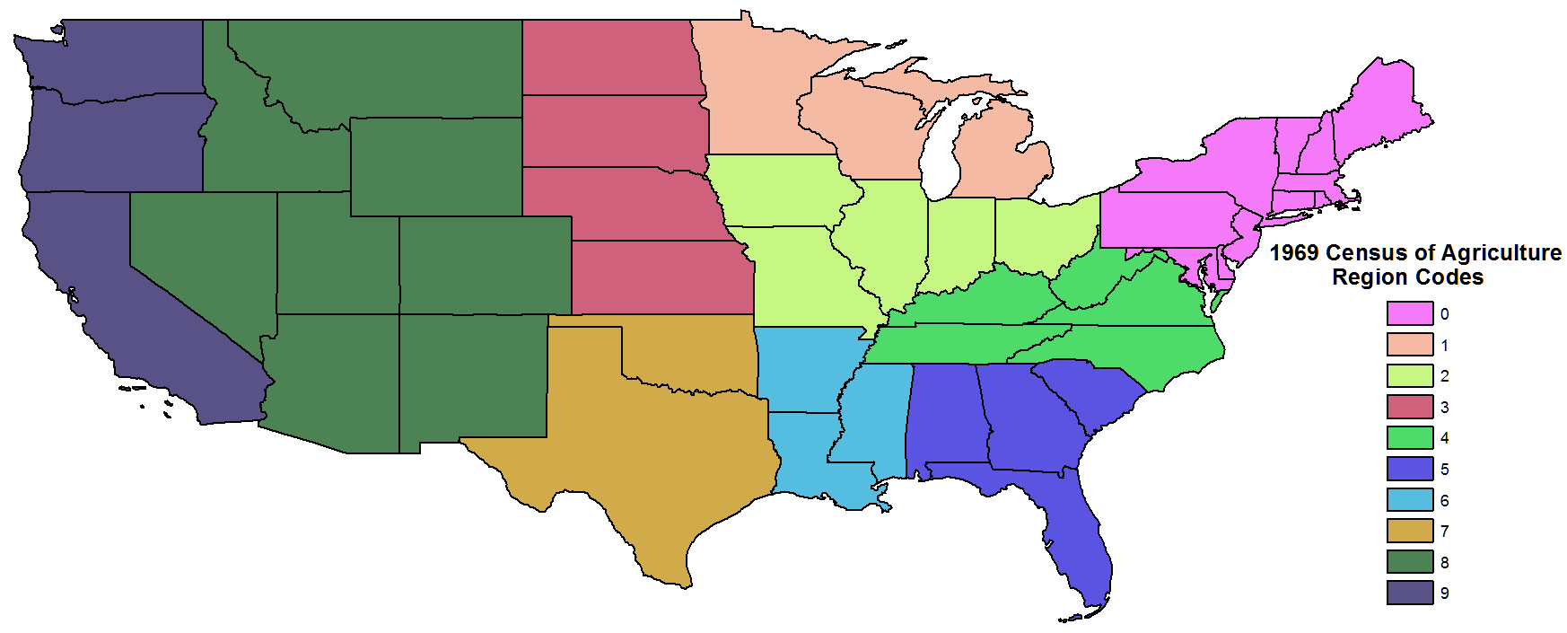
Figure 2. Data set B02: 1969 Census of Agriculture Region Codes (C_AG_RGN)
Climate
Climate data sets in the Geoecology database were calculated from weather station data for the 30-year period 1941-1970. The data include monthly temperature ranges and total rainfall as well as potential evapotranspiration, moisture index, growing season and frost data, rainfall pH, and several other indices at both the county level and within State Climatic Divisions (SCDs).
State Climatic Divisions (SCDs) are areas within states with similar climate. There are 353 SCDs in the United States defined by the National Weather Service. Most follow county boundaries, but some SCDs subdivide counties in mountainous areas. SCD names are listed in C19 and counties within each SCD are listed in C17.
Data sets C07-C10 were derived from the 1941-1970 monthly climatic norms for weather stations. Using the SYMAP program, station values were interpolated to determine county values for temperature and rainfall for counties without weather stations. No correction was made for elevation so caution is recommended when using data in mountainous areas. The resolution is adequate for regional studies. The county values were then used with the Thornthwaite (1948) equations to estimate potential evapotranspiration and moisture indices. C11-16 contain monthly average temperature and rainfall norms for SCDs. The average, minimum, and maximum values were calculated for the period 1941-1970 from a file obtained from the National Climatic Center.
Vegetation
Vegetation data sets in the Geoecology database are based on two interrelated maps of ecoregions and potential natural vegetation. Ecoregions represent a hierarchical landscape classification scheme based on climate, soils, and vegetation. There are 54 ecoregions at the section level in the conterminous United States. The vegetation aspect of the classification scheme is based on potential natural vegetation (Küchler 1964, USDI 1970). Data sets D03 and D04 provide national and county-level summary statistics for potential and land use-adjusted natural vegetation. Data set D05 provides probabilities of conversion from natural vegetation to cropland, pastureland, or inundation for each Küchler vegetation type (Klopatek 1979b). Data set D06 defines vegetation types within western counties that have been urbanized. The data were obtained by overlaying a map of urban areas with Küchler's vegetation map. Data sets D07 and D08 provide national and county-level summary statistics for potential and land use-adjusted ecoregion areas. Data sets D09 and D10 provide national and county-level natural vegetation statistics for each ecoregion. Data set D13 provides sensitivities of potential natural vegetation (Küchler 1964) to sulfur dioxide (SO2), rated by Argonne National Laboratory (Ballou et al. 1979). Individual species' sensitivities were rated sensitive, intermediate, or resistent based on tolerances to SO2 reported in literature. Vegetation communities were classified according to the most sensitive dominant species in the association.
Companion table D11 provides ecoregion codes and names at the province and section levels based on Bailey's 1976 ecoregion map. This table has been combined with other relevant vegetation data sets in the Geoecology database (D08, D09, D10).
Energy
The energy data set (E04) lists power generating facilities by county.
Forestry
The forestry data set (F08) was produced from data collected by the U.S. Forest Service's Continuous Forest Inventory (CFI) program. The CFI program conducts timber surveys on permanently established plots at ten-year intervals.
Air Quality
Air quality statistics were compiled by Lawrence Berkeley Laboratory as part of the Population At Risk to Air Pollution (PARAP) project (Merrill 1980). County-level statistics included in data set K04 were estimated from EPA monitoring data collected to determine compliance with the Clean Air Act and other legislation. County estimates were calculated for the population centroid of the counties located within 60 km of a monitoring station. Air emissions from projected industrial activity were calculated by the Strategic Environmental Assessment System (SEAS) model.
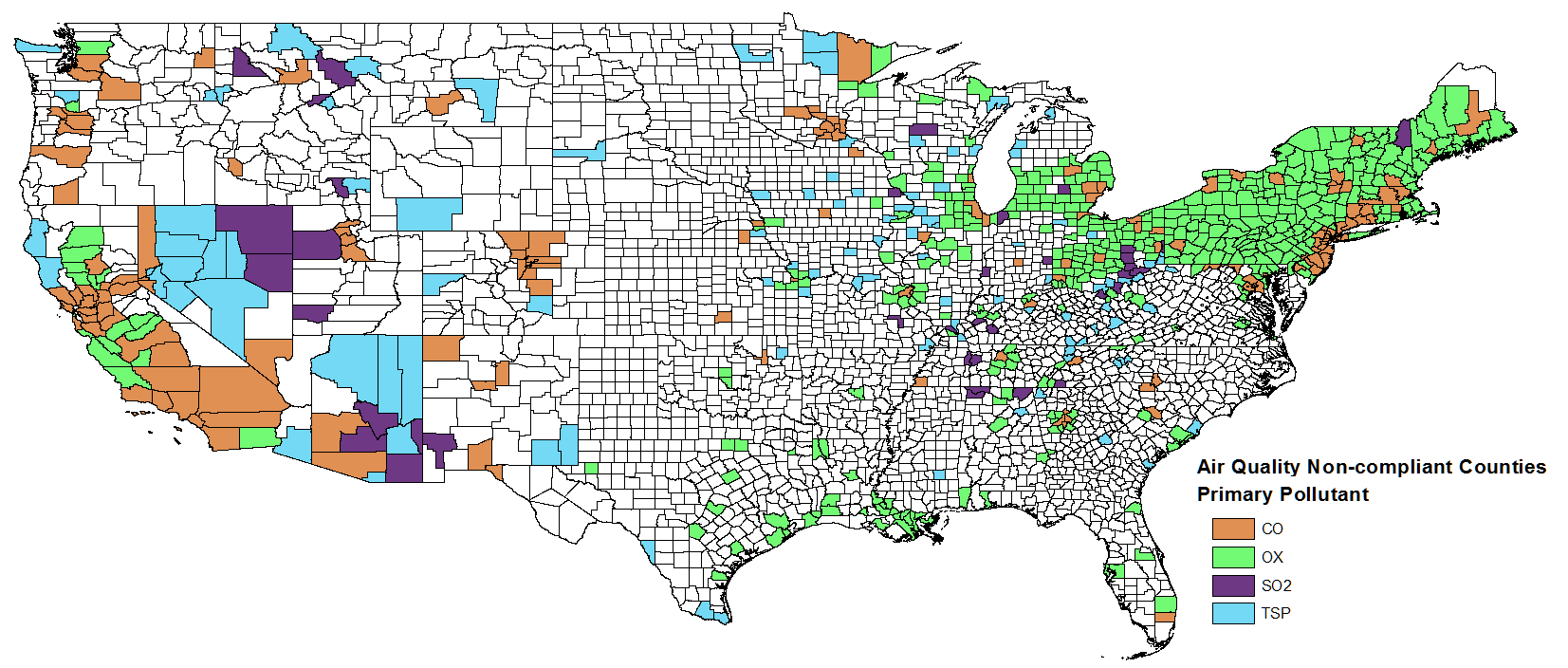
Figure 3. Data set K04: EPA Air Quality Non-Compliance 1979
Land
County-level statistics for land use, land capability, and land use restrictions from the 1967 Conservation Needs Inventory (USDA 1971) are included with the Geoecology database. The CNI is both out-of-date and subject to relatively high statistical sampling errors for individual counties. The inventory is also restricted to non-federal land. Data sets L01, L02, L03, and L07 are based on the CNI. Land Resource Regions (L06) are defined in terms of the agricultural practices and capabilities of the region.
Natural Areas
Natural Areas data sets include parks, wilderness areas, national forests and rangelands, wildlife refuges, ecological preserves, and others. Data sets N01, N04, N05, N06, and N07 pertain to the Roadless Area Review and Evaluation II (RARE II) program in 1978 to inventory existing roadless areas within the National Forests and to determine their management strategies. Data sets N04-07 may be merged with N01 to give complete name and location data.
Population
Data set P01 provides county-level summary population counts for 5-year age groups by sex. Data set P03 provides county-level population and household counts for 1970 and 1980.
Terrain
County-level maps of land form and soils from the National Atlas (USDI 1970) are included in the Terrain data sets of the Geoecology database. Data set T03 provides soil codes for U.S. counties. Data set T07 provides soils map unit codes, soils order codes, and soils suborder codes and their definitions. Data sets T08 and T09 provide summaries of soil classification data within Soil Map Units from USDI 1970. T09 may be used to merge the Great Soil Group Characteristics data set (T08) with the soils distribution data set (T03). Data set T13 contains soil map unit data (T03) aggregated to the soil order level for U.S. counties. Data set T14 provides physiographic region codes within U.S. counties and their definitions are provided in companio file T15. Definitions from companion file T15 are merged with the T14 data set in shapefile format.
Wildlife
Endangered species (animals and plants) codes for U.S. counties obtained from Brookhaven National Laboratory (Nagy and Calef, 1979) are provided in data set W10. Code definitions for all U.S. endangered species are provided in data set W09. Definitions from data set W09 are merged with data set W10 in shapefile format. These data reflect federally designated endangered and threatened species at the time of the data compilation in 1978 and are likely out-of-date.
Data Access
These data are available through the Oak Ridge National Laboratory (ORNL) Distributed Active Archive Center (DAAC).
Geoecology: County-Level Environmental Data for the United States, 1941-1981
Contact for Data Center Access Information:
- E-mail: uso@daac.ornl.gov
- Telephone: +1 (865) 241-3952
References
Bailey, R. G. 1976. Ecoregions of the United States. U. S. Department of Agriculture, Forest Service, Washington, DC. (map) . Bailey, R. G. 1978. Descriptions of Ecoregions of the United States. U. S. Forest Service, Ogden, UT. 77 pp.
Barr, J. T. May, 1979. 1972-1977 County Crop Estimates magnetic tape. U. S. Department of Agriculture, Economics, Statistics, and Cooperatives Service, Washington, DC.
Ballou, S. W. 1979. Unpublished manuscript. Argonne National Laboratory, Argonne, IL.
Breen, J. T. 1972. 1969 Census of Agriculture magnetic tape file. U. S. Department of Commerce, Bureau of the Census, Agriculture Division, Washington, DC.
Kitchings, T., S. Anderson, and R. J. Olson. 1976. Biogeographic Information System for Animal Species in the Southeastern United States. ASB Bulletin 23(3):149-154.
Klopatek, J. M., J. T. Kitchings, R. J. Olson, K. D. Kumar, and L. K. Mann. 1979a. A hierarchical system for evaluating regional ecological resources. Biological Conservation 20(4):271-290.
Klopatek, J. M., R. J. Olson, C. J. Emerson, and J. L. Jones. 1979b. Land-use conflicts with natural vegetation in the United States. Environmental Conservation 6:191-199.
Küchler, A. W. 1964. Potential natural vegetation of the conterminous United States (map and manual). Special Pub. 36. American Geographical Society.
Merrill, D. 1977. EPA County Index Computer File. Lawrence Berkeley Laboratory, Berkeley, CA.
Calef, C., and J. Nagy. 1979. Assessment of endangered species - energy development conflicts: Method s development. Unpublished Project Report. Brookhaven National Laboratory, Upton, NY. 37 pp.
Olson, R. J., C. J. Emerson, and M. K. Nungesser. 1980. GEOECOLOGY: A County-Level Environmental Data Base for the Conterminous United States. ORNL/TM-7351. Oak Ridge National Laboratory, Oak Ridge, Tennessee.
Olson, R. J., K. D. Kumar, and R. L. Burgess. 1982. Analyses of Ecoregions Utilizing the Geoecology Data Base. pp. 149-156. In: In-Place Resource Inventories: Principles and Practices, Society of American Foresters.
Olson, R. J., J. M. Klopatek, and C. J. Emerson. 1983. Regional environmental analysis and assessment utilizing the Geoecology Data Base. pp. 102-118. In: E. Teicholz and B. J. L. Berry (eds.), Computer Graphics and Environmental Planning, Prentice-Hall, Inc., Englewood Cliffs, New Jersey.
Thornthwaite, C. W. 1948. An approach toward a national classification of climate. Geogr. Rev. 38:55-94.
U. S. Department of Agriculture (USDA). 1971. Basic statistics - National inventory of soil and water conservation needs, 1967. Statistical Bulletin No. 461. U. S. Department of Agriculture, Washington, DC. 211 pp.
U. S. Department of Interior (USDI). 1970. The national atlas of the United States of America. U. S. Department of Interior, Geological Survey, Washington, DC.
Wilson, D. L. 1978. AQCR and WRC-SA Computer File. Computer Sciences Division, UCCND, Oak Ridge, TN.
Data Set Revisions
Revision Summary:
- This data set has been revised to include county-level data tables from the Geoecology database in shapefile format. No changes have been made to the data values.
- Five files (D11.txt, G01.txt, G02.txt, T07.txt, T15.txt) from the original Geoecology database (cited below) are now distributed as companion files.
- Coded variables were decoded in adjacent columns within the data files where possible. E.g. Ecoregion code definitions within vegetation data tables D08, D09, and D10 were given in adjacent columns using the information in companion file D11.
Revision History:
Original Citation
Olson, R. J., C. J. Emerson, and M. K. Nungesser. 2003. GEOECOLOGY: County-Level Environmental Data for the United States, 1964-1979. Data set. Available on-line [http://www.daac.ornl.gov] from Oak Ridge National Laboratory Distributed Active Archive Center, Oak Ridge, Tennessee, U.S.A. doi:10.3334/ORNLDAAC/656.