Documentation Revision Date: 2017-01-11
Data Set Version: V1
Summary
There is one data file in GeoTIFF (.tif) format with this data set.

Figure 1. Stand age distribution map for the Siberian Larch forests in 2012. Insets show views of three subsets of the stand age map (from Chen et al., 2016).
Citation
Chen, D., T.V. Loboda, A. Krylov, and V. Potapov. 2017. Distribution of Estimated Stand Age Across Siberian Larch Forests, 1989-2012. ORNL DAAC, Oak Ridge, Tennessee, USA. http://dx.doi.org/10.3334/ORNLDAAC/1364
Table of Contents
- Data Set Overview
- Data Characteristics
- Application and Derivation
- Quality Assessment
- Data Acquisition, Materials, and Methods
- Data Access
- References
Data Set Overview
This data set provides mapped estimates of stand age distribution of young (< 25 years old) larch forests across Siberia from 1989-2012 at 30-m resolution. The age estimates were derived from Landsat-based composites and tree cover for years 2000 and 2012 developed by the Global Forest Change (GFC) project (Hansen et al., 2013), and the stand-replacing fire mapping (SRFM) data set (Krylov et al., 2014). This approach is based on the assumption that the relationship between the spectral signature of a burned or unburned forest stand acquired by Landsat ETM + and TM sensors and stand age before and after the year 2000 is similar thus allowing for training of an algorithm on the data from the post-2000 era and applying the algorithm to infer stand age for the pre-2000 era. The output map combines the modeled forest disturbances before 2000 and direct observations of forest loss after 2000 to deliver a 24-year stand age distribution map.
A two-pronged approach was developed to produce this record of fire-induced forest dynamics across the Siberian larch forests using the SRFM data and the post-2000 Landsat observations. First, the SRFM was adopted to produce a post-2000 forest stand age map. Second: (1) post-2000 Landsat images were used to define spectral signatures of recovering forests in year 2012 following known (in space and time) stand-replacing fire events from the post-2000 forest stand age map; (2) a random forest-based algorithm was developed that reliably separated recovering forests of different ages; and (3) the algorithm was applied to identify and map areas with similar spectra in the year 2000 which would have resulted from disturbance events that occurred 12 years prior to year 2000. The outcome of the second effort was the pre-2000 map of forest stand age. The pre-2000 map was then merged with the post-2000 map to produce a single continuous map of stand age distribution focused on young (< 25 years old) Siberian larch forests from 1989-2012.
Related Publication:
Chen, D., T.V. Loboda , A. Krylov , and P.V. Potapov. 2016. Mapping stand age dynamics of the Siberian larch forests from recent Landsat observations. Remote Sensing of Environment, Vol 187: 320-331. http://dx.doi.org/10.1016/j.rse.2016.10.033
Related Data Sets:
Loboda, T.V., and D. Chen. 2016. Distribution of Young Forests and Estimated Stand Age across Russia, 2012. ORNL DAAC, Oak Ridge, Tennessee, USA. http://dx.doi.org/10.3334/ORNLDAAC/1330
Chen, D., T.V. Loboda, S. Channan, and A. Hoffman-Hall. 2015. Russian Boreal Forest Disturbance Maps Derived from Landsat Imagery, 1984-2000. ORNL DAAC, Oak Ridge, Tennessee, USA. http://dx.doi.org/10.3334/ORNLDAAC/1294
Data Characteristics
Spatial Coverage: Siberia, Russia
Spatial Resolution: 30 m
Temporal Coverage: 19890101 to 20121231
Temporal Resolution: Annual
Study Area: (all latitudes and longitudes given in decimal degrees)
| Site | Westernmost Longitude | Easternmost Longitude | Northernmost Latitude | Southernmost Latitude |
|---|---|---|---|---|
| Siberia, Russia | 90 | 143 | 67 | 49 |
Data file information
There is one data file with this data set in GeoTIFF format.
Table 1: Data file name and description
| Data File | Description |
|---|---|
| Siberian_larch_forests_stand_age.tif | A 24 year map of stand age spatial distribution of Siberian larch forests focused on the years 1989-2012. |
Table 2: Attributes of the GeoTIFF file
| File Name | Map units | Fill Value | Data Type | Number of Bands | Range of Values |
|---|---|---|---|---|---|
| Siberian_larch_forests_stand_age.tif | degrees | 255 | Byte | 1 | 0 - 100 |
Table 3: Attribute class definitions. Note that class values 0-23 are the larch stand ages in years relative to 2012, while class value 100 denotes all larch forests with stand ages >23 years.
| Stand Age Class Value | Stand Age in years | Year of Burn |
| 0 | 0 | 2012 |
| 1 | 1 | 2011 |
| 2 | 2 | 2010 |
| 3 | 3 | 2009 |
| 4 | 4 | 2008 |
| 5 | 5 | 2007 |
| 6 | 6 | 2006 |
| 7 | 7 | 2005 |
| 8 | 8 | 2004 |
| 9 | 9 | 2003 |
| 10 | 10 | 2002 |
| 11 | 11 | 2001 |
| 12 | 12 | 2000 |
| 13 | 13 | 1999 |
| 14 | 14 | 1998 |
| 15 | 15 | 1997 |
| 16 | 16 | 1996 |
| 17 | 17 | 1995 |
| 18 | 18 | 1994 |
| 19 | 19 | 1993 |
| 20 | 20 | 1992 |
| 21 | 21 | 1991 |
| 22 | 22 | 1990 |
| 23 | 23 | 1989 |
| 100 | >23 (Unburned Forests) | N/A |
| 255 | Unclassified (Non-larch and non-forested areas) | N/A |
Application and Derivation
The stand age dynamics revealed by this data set are important for quantifying the feedback of forest cover to the climate system through carbon cycling and surface albedo which are strongly related to stand age.
Quality Assessment
Due to a lack of reference data, the produced stand age map was assessed in a relatively unconventional fashion, by incorporating two sets of data, each focusing on a different aspect of the performance of the produced data. In the first assessment, the ability of the produced data set to differentiate the burned forests from the unburned ones was assessed against the Landsat images captured for circa 1989, 2000 and 2012. At the 95% confidence level, both the pre- and post-2000 components of the stand age map have high overall accuracy (i.e. 0.97±0.02 for the former and 0.98±0.01 for the latter). The pre-2000 component has relatively lower accuracy, in terms of both the producer's (0.56±0.17 versus 0.80±0.16) and user's (0.81±0.06 versus 0.92±0.04) accuracy, in mapping the burned forests than the post-2000 component, which was expected. In the second assessment, the pre-2000 component of the produced map was evaluated against the Advanced Very High Resolution Radiometer (AVHRR)-based fire mapping (ABFM) product for its accuracy to estimate the ages of the burned forests. The assessment showed that there is generally a good consistency between the produced map and the reference data, as indicated in a series of histograms. See Chen et al. (2016) for more information.
Data Acquisition, Materials, and Methods
Site description
The Siberian larch forests are a major and unique component of the circumpolar boreal biome covering more than 15 million km2 of land. The study was focused on the contiguous area of larch dominance in Siberia, Russia. The dominant larch species in the region are Larix gmelinii in the west and Larix cajanderi in the east. Wildfires are the dominant disturbance agent in Siberian forests and exert a strong control on stand age distribution (Chen et al., 2016).
The stand age spatial distribution of burned/unburned forests were mapped across the entire Siberian larch forest region from 1989-2012 at 30-m resolution. For the burned forests, stand ages were either estimated based on a random forest classifier (for those burned during 1989-2000) or identified through continuous tracking (for those burned during 2001-2012). The final product is a single continuous map of stand age distribution focused on young (< 25 years old) Siberian larch forests.The methods are generally described below and in detail in Chen et al. (2016).
Data inputs
Landsat-based composites and tree cover for circa year 2000 and 2012 developed by the Global Forest Change (GFC) project were used as data inputs. Generated based on images captured during the growing season (i.e. June–August), the cloud-free composites included four spectral bands of the Landsat ETM + (Band 3 - red, 4 - near infrared (NIR), 5 - short-wave infrared (SWIR1.6) and 7 - SWIR2.2), all of which were converted from original digital values to normalized top-of-atmosphere (TOA) reflectance.
The stand-replacing fire mapping (SRFM) data set produced by Krylov et al. (2014) was also used to identify the areas of stand-replacing fires which occurred in the Russian boreal forests annually between 2001 and 2012 (year 2001 and 2012 were absent from the initial publication of the SRFM product and were later included into the data set) at 30-m resolution. It is a regionally enhanced product which was derived based on a data fusion of the GFC tree cover and forest loss products (Hansen et al., 2013), 1-km MODIS active fire data (Giglio et al., 2003) and 500-m MODIS-based Regional Burned Area Mapping Product for Russia (Loboda et al., 2007 and Loboda et al., 2011). The fusion of the Landsat-scale detail with the MODIS temporal scope allowed the SRFM product to identify the timing of fire events with great accuracy.
Table 4. Data inputs
|
Data set name |
Used in |
Original spatial coverage |
Spatial resolution |
Temporal span |
|---|---|---|---|---|
|
GFC Landsat-based TOA reflectance composites |
Map production |
Global |
30 m |
circa 2000 and 2012 |
|
GFC Landsat-based tree cover |
Map production |
Global |
30 m |
circa 2000 and 2012 |
|
Stand-replacing fire mapping (SRFM) |
Map production |
Russia |
30 m |
2001–2012 |
|
Landsat images |
Accuracy assessment |
Siberian larch forests |
30 m |
circa 1989, 2000 and 2012 |
|
Advanced Very High Resolution Radiometer (AVHRR)-based fire mapping (ABFM) |
Accuracy assessment |
Russia |
1 km |
1995–2002 |
Mapping of stand age distribution
A two-pronged approach to producing a 24-year record of fire-induced forest dynamics across the Siberian larch forests using only post-2000 Landsat observations was developed. The general workflow of the map development is presented in Fig. 2. This approach combines two different methods to produce a single map.
- Within the first method, SRFM (Krylov et al., 2014), was adapted to produce a post-2000 forest stand age map.
- Within the second method - the novel method introduced in this study - post-2000 imagery were used to:
- Define spectral signatures of recovering forests in year 2012 following known (in space and time) stand-replacing fire events from the post-2000 forest stand age map described above
- Build a random forest-based algorithm that can reliably separate recovering forests of different ages
- Apply the developed algorithm to identify and map areas with similar spectra in the year 2000 which would have resulted from disturbance events that occurred prior to year 2000
The outcome of the second method is the pre-2000 map of forest stand age. The pre-2000 map was then merged with the post-2000 map to produce a single continuous map of stand age distribution focused on young (< 25 years old) Siberian larch forests.
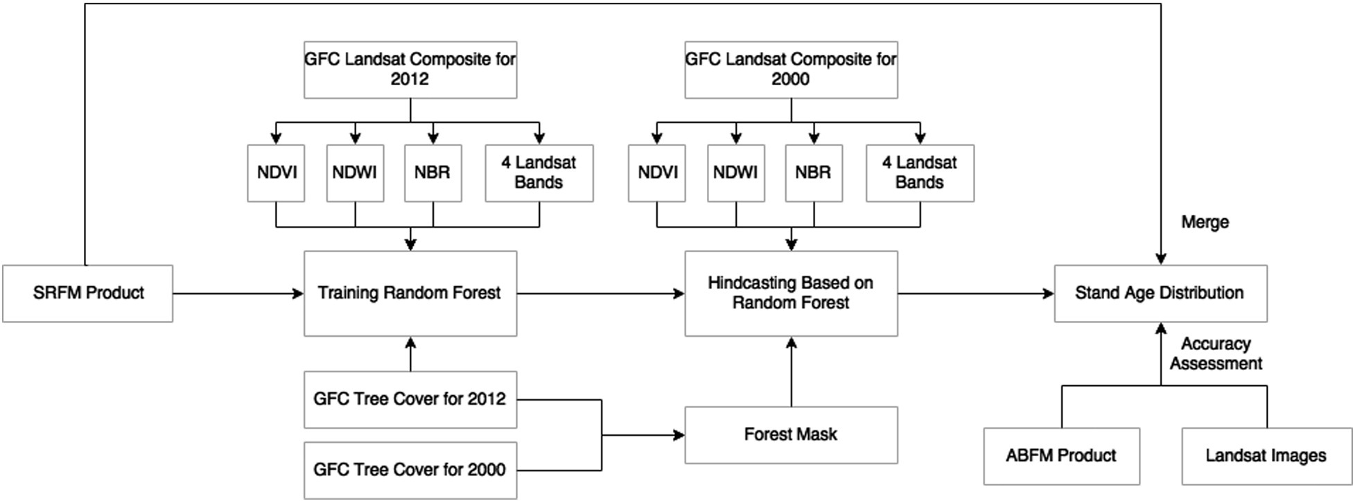
Figure 2. General workflow for the map development (from Chen et al., 2016).
Data Access
These data are available through the Oak Ridge National Laboratory (ORNL) Distributed Active Archive Center (DAAC).
Distribution of Estimated Stand Age Across Siberian Larch Forests, 1989-2012
Contact for Data Center Access Information:
- E-mail: uso@daac.ornl.gov
- Telephone: +1 (865) 241-3952
References
Chen, D., T.V. Loboda , A. Krylov , and P.V. Potapov. 2016. Mapping stand age dynamics of the Siberian larch forests from recent Landsat observations. Remote Sensing of Environment, Vol 187: 320-331. http://dx.doi.org/10.1016/j.rse.2016.10.033
Giglio, L. J. Descloitres, C.O. Justice, and Y.J. Kaufman. An enhanced contextual fire detection algorithm for MODIS. Remote Sens. Environ., 87 (2003), pp. 273–282. http://dx.doi.org/10.1016/S0034-4257(03)00184-6
Hansen, M.C., P.V. Potapov, R. Moore, M. Hancher, S.A. Turubanova, A. Tyukavina, D. Thau, S.V. Stehman, S.J. Goetz, T.R. Loveland, A. Kommareddy, A. Egorov, L. Chini, C.O. Justice, J.R.G. Townshend. High-resolution global maps of 21st-century forest cover change Science, 342 (2013), pp. 850–853 http://dx.doi.org/10.1126/science.1244693
Krylov, A. J.L. McCarty, P. Potapov, T. Loboda, A. Tyukavina, S. Turubanova, M.C. Hansen Remote sensing estimates of stand-replacement fires in Russia, 2002–2011Environ. Res. Lett., 9 (2014), Article 105007 http://dx.doi.org/10.1088/1748-9326/9/10/105007
Loboda, T.V., E.E. Hoy, L. Giglio, and E.S. Kasischke. Mapping burned area in Alaska using MODIS data: a data limitations-driven modification to the regional burned area algorithm. Int. J. Wildland Fire, 20 (2011), pp. 487–496. http://dx.doi.org/10.1071/WF10017
Loboda, T.V., K.J. O'Neal, and I. Csiszar. Regionally adaptable dNBR-based algorithm for burned area mapping from MODIS data Remote Sens. Environ., 109 (2007), pp. 429–442. http://dx.doi.org/10.1016/j.rse.2007.01.017