Documentation Revision Date: 2024-05-15
Dataset Version: 1
Summary
This data set contains 42 files: 28 data files in LiDAR (*.laz) file format, 12 DTMs in GeoTIFF (*.tif) format, along with one shapefile (*.shp) and one file in compressed Keyhole Markup Language (KMZ) providing the LiDAR file footprints.
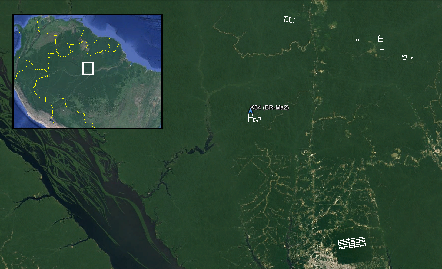
Figure 1. Footprints for surveyed areas in Amazonas, Brazil are included in amazonas_lidar_footprints.kmz. The K34 eddy flux tower (AmeriFlux BR-Ma2) is within the surveyed area at the Cuieiras Biological Reserve.
Citation
Lefsky, M.A., S.R. Saleska, and Y.E. Shimabukuro. 2017. LiDAR and DTM Data from Forested Land Near Manaus, Amazonas, Brazil, 2008. ORNL DAAC, Oak Ridge, Tennessee, USA. https://doi.org/10.3334/ORNLDAAC/1515
Table of Contents
- Dataset Overview
- Data Characteristics
- Application and Derivation
- Quality Assessment
- Data Acquisition, Materials, and Methods
- Data Access
- References
- Dataset Revisions
Dataset Overview
This data set provides LiDAR point clouds and digital terrain models (DTM) from surveys over the K34 tower site in the Cuieiras Biological Reserve, over forest inventory plots in the Adolpho Ducke Forest Reserve, and over sites of the Biological Dynamics of Forest Fragments Project (BDFFP) in Rio Preto da Eva municipality near Manaus, Amazonas, Brazil during June 2008. The surveys encompass the K34 eddy flux tower managed through the Large-scale Biosphere-Atmosphere Experiment in Amazonia, forest inventory plots managed by the Programa de Pesquisa em Biodiversidade (PPBio), and sites managed by the BDFFP. The LiDAR data was collected to measure forest canopy structure across Amazonian landscapes to monitor the effects of selective logging on forest biomass and carbon balance, and forest recovery over time.
Related Data Sets:
Miller, J.B., L.V. Gatti, M.T.S. D'Amelio, A. Crotwell, E. Dlugokencky, P.S. Bakwin, P.E. Artaxo, and P. Tans. 2013. LBA-ECO TG-06 Vertical Profiles of Atmospheric Trace Gases over the Amazon Basin. ORNL DAAC, Oak Ridge, Tennessee, USA. https://doi.org/10.3334/ORNLDAAC/1175
dos-Santos, M.N., and M.M. Keller. 2016. CMS: LiDAR Data for Forested Areas in Paragominas, Para, Brazil, 2012-2014. ORNL DAAC, Oak Ridge, Tennessee, USA. https://doi.org/10.3334/ORNLDAAC/1302
Martin, S.T., P.E. Artaxo, Q. Chen, A.B. Guenther, S.S. Gunthe, J.L. Jimenez, A. Manzi, K.L. Prenni, U. Poschl, J. Schneider, and E. Swietlicki. 2016. AMAZE-08 Aerosol Characterization and Meteorological Data, Central Amazon Basin: 2008. ORNL DAAC, Oak Ridge, Tennessee, USA. https://doi.org/10.3334/ORNLDAAC/1308
Lefsky, M.A., S.R. Saleska, and Y.E. Shimabukuro. 2017. LiDAR and DTM Data from Tapajos National Forest in Para, Brazil 2008. ORNL DAAC, Oak Ridge, Tennessee, USA. https://doi.org/10.3334/ORNLDAAC/1514
Acknowledgements:
The survey campaigns were funded through grants from NASA (#NNX09AI33G; M. Lefsky et al.) and the NSF (#0721140; S. Saleska, G.G. Parker, Y. Shimabukuro et al.). Additional funding was provided by the Smithsonian Tropical Research Institute for the surveys of Rio Preto da Eva.
Data Characteristics
Spatial Coverage: LiDAR surveys over forest reserves and municipalities north of Manaus in Amazonas, Brazil
Spatial Resolution: LiDAR: ~10 points per m2 ; DTMs: 1 m
Temporal Coverage: 2008-06-07 to 2008-06-24
Temporal Resolution: One-time flights
Study Area: (all latitude and longitudes given in decimal degrees)
| Site | Westernmost Longitude | Easternmost Longitude | Northernmost Latitude | Southermost Latitude |
|---|---|---|---|---|
| Forest reserves and municipalities north of Manaus in Amazonas, Brazil | -60.215 | -59.764 | -2.32 | -2.98 |
Data File Information
This data set contains 42 files: 28 data files in LiDAR (*.laz) file format, 12 DTMs in GeoTIFF (*.tif) format, along with one shapefile in a zip archive (*.zip) and one file in compressed Keyhole Markup Language (.kmz) providing the LiDAR file footprints.
There are 28 LiDAR point cloud (*.laz) files and 12 digital terrain models (DTM; *.tif) included in this data set.
The survey footprints are provided as a shapefile (4 files in amazonas_lidar_footprints.zip) with the footprint of each LAZ file as a feature record identified by the "FILE" attribute. The spatial reference properties for the data files are listed below and additional metadata for each of the survey areas is provided in Table 1.
The shapefile is also provided as a companion file in KMZ (*.kmz) format for viewing in Google Earth.
Data files are named according to the survey area.
| Filename | Survey Area |
|---|---|
| CUI_* | Cuieiras Forest Reserve, Amazonas, Brazil |
| DUC_* | Adolphos Ducke Forest Reserve, Amazonas, Brazil |
| PRE_* | Rio Preto da Eva Municipality, Amazonas, Brazil |
Spatial Reference Properties
WGS_1984_UTM_Zone_20S, EPSG 32720
Projection: Transverse_Mercator
false_easting: 500000.0
false_northing: 10000000.0
central_meridian: -63.0
scale_factor: 0.9996
latitude_of_origin: 0.0
Linear Unit: Meter (1.0)
Geographic Coordinate System: GCS_WGS_1984
Angular Unit: Degree (0.0174532925199433)
Prime Meridian: Greenwich (0.0)
Datum: D_WGS_1984
Spheroid: WGS_1984
Semimajor Axis: 6378137.0
Semiminor Axis: 6356752.314245179
Inverse Flattening: 298.257223563
Table 1. Metadata for LiDAR survey areas
| Survey Area | Date(s) | Number of tiles | Total area (ha) | Avg. point density (ppm2) | Avg. first return density (ppm2) | Avg. flight altitude (m) |
|---|---|---|---|---|---|---|
| CUI_A01 | 2008-06-09, 2008-06-22 | 4 | 545.77 | 12.21 | 9.51 | 833 |
| DUC_A01 | 2008-06-08, 2008-06-09, 2008-06-22, 2008-06-24 | 14 | 1199.95 | 55.46 | 42.76 | 816 |
| PRE_A01 | 2008-06-22 | 2 | 409 | 12.09 | 9.3 | 723 |
| PRE_A02 | 2008-06-10 | 1 | 41.9 | 11.02 | 8.5 | 777 |
| PRE_A04 | 2008-06-07 | 2 | 242.32 | 13.10 | 10.21 | 880 |
| PRE_A05 | 20080-6-07 | 1 | 138.41 | 12.03 | 9.06 | 879 |
| PRE_A06 | 2008-06-10 | 1 | 124.02 | 12.99 | 10.08 | 812 |
| PRE_A07 | 2008-06-10 | 3 | 8.85 | 15.08 | 11.76 | 881 |
Application and Derivation
The LiDAR data was collected to measure forest canopy structure across Amazonian landscapes to monitor the effects of selective logging on forest biomass and carbon balance and forest recovery over time (Stark et al., 2012).
Quality Assessment
Checks for horizontal and vertical accuracy, and other standard quality control measures were performed by dataset vendors. Refer to http://mapas.cnpm.embrapa.br/paisagenssustentaveis/ for vendor information.
Data Acquisition, Materials, and Methods
Sites
The Cuieiras Biological Reserve and Adolpho Ducke Forest Reserve are located near Manaus in Amazonas, Brazil and are part of the Long Term Ecological Research Network. The survey areas within Adolpho Ducke Forest Reserve encompass long-term monitoring plots managed by the Brazilian PPBio Project (de Castilho et al., 2006) and sits at the intersection of two major drainage areas, the Amazon River and the Rio Negro. The survey areas within Cuieiras Biological Reserve encompass the K34 eddy flux tower and forest inventory plots managed through the LBA project (Araújo, 2002). The K34 tower is deployed in a medium elevation plateau with primary forest cover about 60 km north of Manaus. The K34 tower has been in continuous operation since 1999. Please visit the Ameriflux website for additional information and access to the eddy flux tower data (http://ameriflux.lbl.gov/).
Rio Preto da Eva is a municipality located east of Manaus in Amazonas, Brazil encompassing most of the study area for the Biological Dynamics of Forest Fragments project. The project was established in 1985 to monitor the dynamics of forested land in different states of fragmentation and recovery from logging (Bierregaard, et al., 1992).
The surveyed areas average 2145 mm of precipitation annually with temperatures ranging from 24 to 33 °C and averaging 27.4 °C. The Brazilian state of Amazonas is covered almost entirely by Amazon rainforest and is the most species-rich tract of tropical rainforest in the world.
Data Acquisition
LiDAR surveys were flown over the survey sites in June 2008 with a Leica ALS-50 instrument LiDAR (Heerbrugg, Switzerland), funded by grants from NASA (#NNX09AI33G to M. Lefsky et al.) and NSF (#0721140 to S. Saleska, G.G. Parker, Y. Shimabukuro et al.). The data were collected and processed to point cloud and DTM files by commercial vendors under these grants, and incorporated into the broader integrated effort of the Sustainable Landscapes project. Sustainable Landscapes is supported by the United States Agency for International Development (USAID) and US Department of State. LiDAR surveys performed through the Sustainable Landscapes project were commissioned by the United States Forest Service in collaboration with the Brazilian Enterprise for Agricultural Research (EMBRAPA).
Data Access
These data are available through the Oak Ridge National Laboratory (ORNL) Distributed Active Archive Center (DAAC).
LiDAR and DTM Data from Forested Land Near Manaus, Amazonas, Brazil, 2008
Contact for Data Center Access Information:
- E-mail: uso@daac.ornl.gov
- Telephone: +1 (865) 241-3952
References
Araújo, A.C., 2002. Comparative measurements of carbon dioxide fluxes from two nearby towers in a central Amazonian rainforest: The Manaus LBA site. J. Geophys. Res. 107. https://doi.org/10.1029/2001JD000676
Bierregaard, R.O., T.E. Lovejoy, V. Kapos, and R.W. Hutchings. 1992. The Biological Dynamics of Tropical Rainforest Fragments. BioScience 42, 859–866. https://doi.org/10.2307/1312085
de Castilho, C.V., W.E. Magnusson, R.N.O. de Araújo, R.C.C. Luizão, F.J. Luizão, A.P. Lima, and N. Higuchi. 2006. Variation in aboveground tree live biomass in a central Amazonian Forest: Effects of soil and topography. For. Ecol. Manag. 234, 85–96. https://doi.org/10.1016/j.foreco.2006.06.024
Hunter, M.O., M. Keller, D. Morton, B. Cook, M. Lefsky, and M. Ducey et al. (2015) Structural Dynamics of Tropical Moist Forest Gaps. PLoS ONE 10(7): e0132144. https://doi.org/10.1371/journal.pone.0132144
Stark, S.C., V. Leitold, J. L. Wu, M.O. Hunter, C.V. de Castilho, F.R.C. Costa, S.M. McMahon, G.G. Parker, M.T. Shimabukuro, M.A. Lefsky, M. Keller, L.F. Alves, J. Schietti, Y.E. Shimabukuro, D.O. Brandão, T.K. Woodcock, N. Higuchi, P.B. de Camargo, R.C. de Oliveira, and S.R. Saleska. 2012. Amazon forest carbon dynamics predicted by profiles of canopy leaf area and light environment. Ecology Letters 15: 1406-1414. https://doi.org/10.1111/j.1461-0248.2012.01864.x
Stark, S.C., B.J. Enquist, S.R. Saleska, V. Leitold, J. Schlietti, M. Longo, L.F. Alves, P.B. Camargo, and R.C. Oliveira. 2015. Linking canopy leaf area and light environments with tree size distributions to explain Amazon forest demography. Ecology Letters. https://doi.org/10.1111/ele.12440
Dataset Revisions
|
Version |
Release Date | Revision Notes |
|---|---|---|
| 2024-XX-XX | DUC_*.laz files renamed to conform to file naming convention. The LiDAR footprint files (*.zip, *.kmz) were regenerated to fix unclosed polygons. The KMZ file was moved from companion files to data files. | |
| 1.0 | 2017-08-15 | Original release |