Get Data
Revision Date: May 22, 2014
Summary:
This data set provides an integrated collection of (1) ground-based meteorological, radiometric, and vegetation measurements, (2) flux-based estimates of gross primary production (GPP), and (3) numerous vegetation indices derived from satellite imagery for three eddy covariance flux tower locations near Lincoln, Nebraska, USA. Land use surrounding the towers is cropland with corn and soybeans. Data are reported for selected days during the growing seasons of 2001 through 2008 only when ground-based crop canopy reflectance was measured. Algorithms developed to relate ground-based and satellite spectral information to GPP of the cropland adjacent to the towers are provided.
- AmeriFlux tower-based Level 2 measurements included photosynthetically active radiation (PAR), heat flux, and GPP estimates; see Section 2 for specific towers.
- Ground-based measurements on the corn and soybean vegetation surrounding the towers included total chlorophyll content (Chl) and leaf area index (LAI).
- Ground-based crop canopy reflectance was measured at 5.4 m above the corn and soybean canopy using hyperspectral radiometers (range 400 to 1100 nm) during the growing season from May to October in eight different years (2001-2008). This resulted in 173 measurement campaigns (18 in 2001, 31 in 2002, 34 in 2003, 31 in 2004, 21 in 2005, 15 in 2006, 14 in 2007, and 9 in 2008).
- Spectral bands from Landsat TM and ETM+, MERIS , and MODIS instruments were used to calculate vegetation indices. Vegetation indices related to chlorophyll can be used as a proxy for GPP because of the observed close relationship between GPP and Chl content in crops. Algorithms developed to relate spectral information to the GPP of the cropland adjacent to the towers are provided as companion files.
The study was undertaken as part of the North American Carbon Program (NACP) Mid-Continent Intensive (MCI) campaign.
There is one comma-delimited data file (.csv) with this data set. The equations used for calculated variables and the algorithms developed to relate spectral information to GPP are included as companion files.
Data and Documentation Access:
Get Data: http://daac.ornl.gov/cgi-bin/dsviewer.pl?ds_id=1217
Description and Links to Additional Supplemental Information:
- Table_of_Algorithms.pdf: The algorithms produced (based on these data) relating GPP and reflectance
- Equations_for_calculated_variables.pdf: The equations used for calculated variables (biophysical characteristics and vegetation indices)
Data Citation:
Cite this data set as follows:
Gitelson, A.A. 2014. NACP MCI: Cropland Productivity and Biophysical Properties, Nebraska, USA, 2001-2008. Data set. Available on-line [http://daac.ornl.gov] from ORNL DAAC, Oak Ridge, Tennessee, USA. http://dx.doi.org/10.3334/ORNLDAAC/1217
Table of Contents:
- 1 Data Set Overview
- 2 Data Characteristics
- 3 Applications and Derivation
- 4 Quality Assessment
- 5 Acquisition Materials and Methods
- 6 Data Access
- 7 References
1. Data Set Overview:
Project: North American Carbon Program
The North American Carbon Program (NACP) (Denning et al., 2005; Wofsy and Harris, 2002) is a multidisciplinary research program to obtain scientific understanding of North America's carbon sources and sinks and of changes in carbon stocks needed to meet societal concerns and to provide tools for decision makers. Successful execution of the NACP has required an unprecedented level of coordination among observational, experimental, and modeling efforts regarding terrestrial, oceanic, atmospheric, and human components. The project has relied upon a rich and diverse array of existing observational networks, monitoring sites, and experimental field studies in North America and its adjacent oceans. It is supported by a number of different federal agencies through a variety of intramural and extramural funding mechanisms and award instruments.
This data set was collected as part of the North American Carbon Program (NACP) Mid-Continent Intensive (MCI) campaign.
This data set provides an integrated collection of (1) ground-based meteorological, radiometric, and vegetation measurements, (2) flux-based estimates of gross primary production (GPP), and (3) numerous vegetation indices derived from satellite imagery for three AmeriFlux tower locations near Lincoln, Nebraska, USA. Land use surrounding the towers is cropland with corn and soybeans. Algorithms developed to relate spectral information to the GPP of the cropland adjacent to the towers are provided as companion files.
2. Data Characteristics:
2.1. Spatial Coverage
Site: AmeriFlux towers, Lincoln, Nebraska, USA
Site boundaries: (All latitude and longitude given in degrees and fractions)
| Site (Name) | Site Code | Westernmost Longitude | Easternmost Longitude | Northernmost Latitude | Southernmost Latitude |
|---|---|---|---|---|---|
| Mead - irrigated continuous maize site | US-Ne1 | -96.4766 | -96.4766 | 41.1651 | 41.1651 |
| Mead - irrigated maize-soybean rotation site | US-Ne2 | -96.4701 | -96.4701 | 41.1649 | 41.1649 |
| Mead - rainfed maize-soybean rotation site | US-Ne3 | -96.4397 | -96.4397 | 41.1797 | 41.1797 |
2.2. Temporal Coverage
The data set covers the period 2001/06/12 to 2008/08/15.
2.3. Data File information
The GPP and reflectance data are presented in one csv file: NACP_Crop_GPP_Reflectance_2001_2008.csv.
The algorithms produced based on these data relating GPP and reflectance are provided in the file Table_of_Algorithms.pdf and equations used for calculated variables (biophysical characteristics and vegetation indices) are provided in the file Equations_for_calculated_variables.pdf.
| Column | Column heading | Units/Format | Description |
|---|---|---|---|
| 1 | Year | YYYY | Year in which measurements were made |
| 2 | Date | YYYYMMDD | Date on which measurements were made |
| 3 | Field | Field identification: Sites 1, 2, or 3 | |
| 4 | Field Type | Field type: either Dryland or Irrigated | |
| 5 | Crop | Crop growing at the time of measurement: Bt Corn; Corn or Soybean | |
| 6 | DOY | Day of the year on which measurements were made, with Jan 1= 1 and Dec 31= 365. Data are reported for selected days during the growing season -- ranging from 139 to 282. These are the days ground-based crop reflectance was measured. | |
| 7 | GPP_Day | umol per m2 per s | Daytime GPP derived by averaging hourly GPP values when incoming photosynthetically active radiation [PARin] exceeded 1 umol m-2 s-1 |
| 8 | PARin_Day | umol per m2 per s | Daytime incoming photosynthetically active radiation (PAR) (wavelength from 400 to 700 nm) derived by averaging hourly PARin measurements when PARin exceeded 1 umol m-2 s-1 |
| 9 | fAPAR_Day | unitless | Absorbed fraction of PAR derived by averaging hourly fAPAR when PARin exceeded 1 umol m-2 s-1 |
| 10 | LE_Day | W per m2 | Daytime Latent heat flux derived by averaging hourly measurements when PARin exceeded 1 umol m-2 s-1 |
| 11 | GPP_MDay | umol per m2 per s | Midday GPP derived by averaging hourly GPP values for the period between 10:30 and 15:30 local time (CDT) |
| 12 | PARin_MDay | umol per m2 per s | Midday PARin derived by averaging hourly measurements for the period between 10:30 and 15:30 local time (CDT) |
| 13 | fAPAR_MDay | unitless | Absorbed fraction of PAR derived by averaging hourly fAPAR for the period between 10:30 and 15:30 local time (CDT) |
| 14 | LE_MDay | W per m2 | Midday Latent heat flux derived by averaging hourly measurements for the period between 10:30 and 15:30 local time (CDT) |
| 15 | canopy_Chl | g per m2 | Canopy chlorophyll content calculated as leaf chlorophyll content times LAI |
| 16 | LAI | m2 per m2 | LAI determined destructively |
| 17 | LAIgreen | m2 per m2 | LAI for green leaf material, the photosynthetically functional component of LAI |
| 18 | VF | % | Vegetation fraction (percent vegetation ground cover) |
| 19 | TM_NDVI | unitless | Normalized difference vegetation index calculated from Landsat TM and ETM+ |
| 20 | TM_EVI2 | unitless | Enhanced vegetation index calculated from Landsat TM and ETM+ |
| 21 | TM_WDRVI_05 | unitless | Wide dynamic range vegetation index with alpha equal to 0.05 from Landsat TM and ETM+ |
| 22 | TM_WDRVI_1 | unitless | Wide dynamic range vegetation index with alpha equal to 0.1 from Landsat TM and ETM+ |
| 23 | TM_Green NDVI | unitless | Green vegetation index calculated from Landsat TM and ETM+ |
| 24 | TM_VARI | unitless | Visible atmospherically resistant indices calculated from Landsat TM and ETM+ |
| 25 | TM_CIgreen | unitless | Chlorophyll index green from Landsat TM and ETM+ |
| 26 | MODIS _CIgreen | unitless | Chlorophyll index green calculated from MODIS |
| 27 | MERIS _CIre | unitless | Chlorophyll index red edge calculated from MERIS |
| 28 | R_TM_blue | % | Reflectance for the blue portion of the spectrum (wavelengths of 450 to 520 nm) calculated from simulated TM reported in percent |
| 29 | R_TM_green | % | Reflectance for the green portion of the spectrum (wavelengths of 520 to 600 nm) calculated from simulated TM reported in percent |
| 30 | R_TM_red | % | Reflectance for the red portion of the spectrum (wavelengths of 630 to 690 nm) calculated from simulated TM reported in percent |
| 31 | R_TM_IR | % | Reflectance for the near infrared (NIR) portion of the spectrum (wavelengths of 760 to 900 nm) calculated from simulated TM reported in percent |
| 32 | R_MODIS _green | % | Reflectance for the green portion of the spectrum (wavelengths of 545 to 565 nm) calculated from MODIS reported in percent |
| 33 | R_MERIS _RE | % | Reflectance for the red edge (RE) portion of the spectrum (wavelengths of 703 to 712 nm) calculated from MERIS reported in percent |
| 34 through 84 | R_XXX | % | For the remaining columns the values are ground-based measurements of crop canopy reflectance centered on the specific wavelengths in nanometers named in the column heading and reported in percent. Percent reflectance equation provided in Section 5 |
| Missing data represented by -9999 | |||
Sample data
|
Year,Date,Field,Field Type,Crop,DOY,GPP_Day,PARin_Day,fAPAR_Day,LE_Day, GPP_MDay,PARin_MDay,fAPAR_MDay,LE_MDay,canopy_Chl,LAI,LAIgreen,VF,TM_NDVI,TM_EVI2, TM_WDRVI_05,TM_WDRVI_1,TM_GreenNDVI,TM_VARI,TM_CIgreen,MODIS _CIgreen, MERIS _CIre, R_TM_blue,R_TM_green,R_TM_red,R_TM_IR,R_MODIS _green,R_MERIS _RE,R_400,R_410,R_420,R_430, R_440,R_450,R_460,R_470,R_480,R_490,R_500,R_510,R_520,R_530,R_540,R_550,R_560,R_570,R_580, R_590,R_600,R_610,R_620,R_630,R_640,R_650,R_660,R_670,R_680,R_690,R_700,R_710,R_720,R_730, R_740,R_750,R_760,R_770,R_780,R_790,R_800,R_810,R_820,R_830,R_840,R_850,R_860,R_870,R_880, R_890,R_900 2001,20010612,1,Irrigated,Corn,163,0.545,693.748,0.12,-108.48,0.823,1314.533,0.094,-172.517,-9999,0.355, 0.346,5.963,0.207,0.108,-0.859,-0.736,0.334,-0.136,1.002,1.07,0.337,7.057,9.302,12.241,18.625,8.996, 13.93, 4.963,5.199,5.426,5.706,5.956,6.243,6.482,6.683,6.918,7.126,7.385,7.645,7.977,8.313,8.653,9.003, 9.332,9.647,9.947,10.312,10.53,10.748,11.033,11.322,11.614,11.932,12.192,12.566,12.851,13.21,13.684, 14.177,14.767,15.22,15.616,16.105,16.463,16.915,17.306,17.711,17.961,18.56,18.573,19.044,19.334,19.393, 19.574,20.157,19.74,19.856,18.793 2001,20010621,1,Irrigated,Corn,172,0.701,829.099,0.369,-149.851,1.044,1407.15,0.29,-238.067,-9999,1.294, 1.291,57.786,0.787,0.582,-0.409,-0.088,0.707,0.181,4.815,3.986,3.195,3.81,6.891,4.781,40.068,8.036,9.552, 2.197,2.412,2.654,2.862,2.958,3.097,3.178,3.241,3.349,3.593,3.935,4.47,5.615,6.962,7.819,8.244,8.045,7.259, 6.463,5.894,5.717,5.476,5.159,5.069,4.968,4.728,4.549,4.441,4.554,5.159,7.509,11.596,17.394,25.301,32.966, 37.794,38.273,40.949,41.193,41.38,41.351,41.039,39.311,39.934,40.97,41.18,41.08,40.483,39.997,38.642, 35.236 |
Companion Files:
- Equations used for calculated variables (biophysical characteristics and vegetation indices) are provided in the companion file Equations_for_calculated_variables.pdf.
- The algorithms produced based on these data relating GPP and reflectance are provided in the companion file Table_of_Algorithms.pdf.
3. Data Application and Derivation:
These data allowed for the development of algorithms which accurately estimate GPP from satellite-based reflectance data and chlorophyll related indices for irrigated and rainfed fields of the dominant crops in the state of Nebraska. The algorithms are provided in the companion file Table_of_Algorithms.pdf along with literature citations for more information.
4. Quality Assessment:
Accuracy of the individual algorithms for each vegetation index was assessed and reported with the algorithms in terms of root mean square error (RMSE) in the companion file Table_of_Algorithms.pdf.
5. Data Acquisition Materials and Methods:
Study site
Data were collected from three flux tower study sites located at the University of Nebraska Lincoln Agricultural Research and Development Center near Mead, NE, USA. Sites US-Ne1 and US-Ne2 are 65-hectare fields equipped with center pivot irrigation systems. US-Ne3 is of approximately the same size, but relies entirely on rainfall. Site US-Ne1 has continuous cultivation of maize, while sites US-Ne2 and US-Ne3 have maize-soybean rotations. Site US-Ne1 has been under no-till management until the harvest of 2005. Following the harvest in 2005, the conservation-plow tillage operation was initiated and followed from 2006 through 2008. Sites US-Ne2 and US-Ne3 have been under no-till management from 2001 until 2008. Soils of the study area are deep silty clay loam (Suyker et al., 2005).
The Level 2 micrometeorological eddy covariance data used in this study were collected each year from 2001 through 2008. The complete Level 2 data records for these three sites are available from AmeriFlux (http://ameriflux.ornl.gov/). To have sufficient upwind fetch (in all directions), eddy covariance sensors were mounted 3 m above the ground while the canopy was shorter than 1 m, and later moved to a height of 6.2 m until harvest (details are given in Verma et al., 2005). The study sites represented approximately 90 to 95% of the flux footprint during daytime and 70- 90% during nighttime (e.g., Schuepp et al., 1990).
Calculation of NEE and GPP (See companion file: Equations_for_calculated_variables.pdf)
Daytime net ecosystem exchange (NEE) values were computed by integrating the hourly CO2 fluxes collected by the eddy covariance tower during a day when PARin exceeded 1 mmol/g/m2/d. Daytime estimates of ecosystem respiration (Re) were obtained from the night CO2 exchange and temperature relationship (e.g., Falge et al., 2002). The daytime GPP was then obtained by subtracting daytime respiration from NEE. This approach has been widely used in the context of tower flux measurements and is considered to provide reasonable estimates at the landscape level. Daily GPP was expressed as the integral of the organic matter in grams of carbon produced by all the individual plants through photosynthesis per meter square during a day (gC/m2/d).
PAR measurements (See companion file: Equations_for_calculated_variables.pdf)
Incoming photosynthetically active radiation (PARin) was measured with point quantum sensors (LI-190, LI-COR Inc., Lincoln, NE) aimed upward, and placed 6 m above the surface. PAR reflected by the canopy and soil (PARout) was measured with Li-Cor point quantum sensors aimed downward, and placed at 6 m above the ground. PAR transmitted through the canopy (PARtransm) was measured with Li-Cor line quantum sensors placed at about 2 cm above the ground, pointing upward; PAR reflected by the soil (PARsoil) was measured with Li-Cor line quantum sensors placed about 12 cm above the ground, pointing downward. Absorbed PAR (APAR) was calculated as:
APAR = PARin − PARout − PARtransm + PARsoil
All the daytime radiation values were computed by integrating the hourly measurements during a day, and fAPAR was then calculated as APAR/PARin.
Esitmation of Chl
Total chlorophyll content (Chl) was estimated as Chl= Chlleaf x LAI, where Chlleaf is the chlorophyll content of the collar or ear leaves in maize (Ciganda et al., 2009; Gitelson et al., 2005). Leaf chlorophyll content was retrieved from leaf reflectance measured by an Ocean Optics radiometer using a red edge chlorophyll index (details are in Gitelson et al., 2003a, 2006a; Ciganda et al., 2009).
LAI determination
Leaf area index (LAI) was determined destructively. Within each study site, six small intensive measurement zones (IMZ) were established to represent all major occurrences of soil and crop production. On each sampling date, plants from a 1m length of either of two rows were collected and the total number of plants recorded. Collection rows were alternated on successive dates to minimize edge effects on subsequent plant growth. Plants were kept on ice and transported to the laboratory. In the lab, plants were separated into green leaves, dead leaves, and litter components. Sample leaves were run through an area meter (Model LI-3100, Li-Cor, Inc., Lincoln NE) and the leaf area per plant was determined. For each IMZ, the leaf area per plant was multiplied by the plant population to obtain a total LAI. Total LAI for the six IMZs were then averaged to obtain a site-level value (details in Gitelson et al., 2003b).
Reflectance measurements (See companion file Equations_for_calculated_variables.pdf)
Reflectance measurements were made using hyperspectral radiometers mounted on “Goliath", an all-terrain sensor platform (Rundquist et al., 2004). A dual-fiber optic system, with two intercalibrated Ocean Optics USB2000 radiometers, was used to collect radiometric data in the range 400 to 1100 nm with a spectral resolution of about 1.5 nm. Radiometer 1, equipped with a 25 degree field-of-view optical fiber was pointed downward to measure the upwelling radiance of the crop (Lλmaize). The position of the radiometer above the top of canopy was 5.4 m and kept constant throughout the growing season, yielding a sampling area with a diameter of around 2.4 m. Radiometer 2, equipped with an optical fiber and a cosine diffuser (yielding a hemispherical field of view), was pointed upward to simultaneously measure incident downwelling irradiance (Eλinc) . In order to match the transfer functions of both radiometers, inter-calibration was accomplished by measuring the upwelling radiance (Lλcal) of a white Spectralon (Labshere, Inc., North Sutton, NH) reflectance standard simultaneously with incident downwelling irradiance (Eλcal). Percent reflectance, ρλ, was computed as
![]()
where ρλcal is the reflectance of the Spectralon panel linearly interpolated to match the band centers of each radiometer. Note that ‘maize’ represents measurements over both corn and soybean crops.
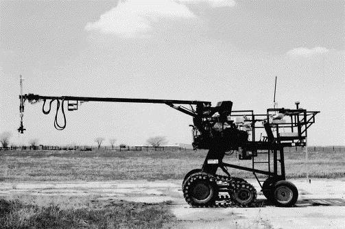
Figure 1. Reflectance measurements were made using hyperspectral radiometers mounted on “Goliath", an all-terrain sensor platform (Rundquist et al., 2004).
Radiometric data were collected close to solar noon (between 11:00 and 13:00 local time), when changes in solar zenith angle were minimal. For each measurement site, six randomly selected plots were established per field, each with six randomly selected sampling points. Thus, a total of 36 points within these areas were sampled per site at each data acquisition, and their median was used as the site reflectance. Measurements took about 5 min per plot and about 30 min per field. The two radiometers were inter-calibrated immediately before and immediately after measurement in each field. Reflectance measurements were carried out during the growing season from May to October over the eight-year period. This resulted in 173 measurement campaigns (18 in 2001, 31 in 2002, 34 in 2003, 31 in 2004, 21 in 2005, 15 in 2006, 14 in 2007, and 9 in 2008).
Resampled Reflectance Spectra
The collected reflectance spectra were resampled to the following spectral bands of Landsat: red (630 to 690 nm), green (520 to 600 nm), NIR (760 to 900 nm), and red edge band (703 to 713 nm) of MERIS (MEdium Resolution Imaging Spectrometer) using the spectral response functions of ETM Landsat and MERIS to calculate the above mentioned vegetation indices.
6. Data Access:
This data is available through the Oak Ridge National Laboratory (ORNL) Distributed Active Archive Center (DAAC).
Data Archive Center:
Contact for Data Center Access Information:
E-mail: uso@daac.ornl.gov
Telephone: +1 (865) 241-3952
7. References:
Ciganda, V., A.A. Gitelson, and J. Schepers. 2009. Non-destructive determination ofmaize leaf and canopy chlorophyll content. J. Plant Physiol. 166, 157-167.
Denning, A.S., et al. 2005. Science implementation strategy for the North American Carbon Program: A Report of the NACP Implementation Strategy Group of the U.S. Carbon Cycle Interagency Working Group. U.S. Carbon Cycle Science Program, Washington, DC. 68 pp.
Falge, E., et al., 2002. Seasonality of ecosystem respiration and gross primary production as derived from FLUXNET measurements. Agric. Forest Meteorol. 113, 53-74.
Gitelson, A.A., S.B. Verma, A. Vina, D.C. Rundquist, G. Keydan, B. Leavitt, T.J. Arkebauer, G.G. Burba, and A.E. Suyker. 2003a. Novel technique for remote estimation of CO2 flux in maize. Geophys. Res. Lett. 30 (9), 1486,doi: 10.1029/2002GL016543.
Gitelson, A.A., U. Gritz, and M.N. Merzlyak. 003b. Relationships between leaf chlorophyll content and spectral reflectance and algorithms for non-destructive chlorophyll assessment in higher plant leaves. J. Plant Physiol. 160 (3), 271-282. doi:10.1078/0176-1617-00887
Gitelson, A.A., A. Vina, S.B. Verma, D.C. Rundquist, T.J. Arkebauer, G. Keydan, B. Leavitt, V. Ciganda, G.G. Burba, and A.E. Suyker. 2006a. Relationship between gross primary production and chlorophyll content in crops: implications for the synoptic monitoring of vegetation productivity. J. Geophys. Res. 111, D08S11, doi:10.1029/2005JD006017.
Gitelson , A.A., Y. Peng, J.G. Masek, D.C. Rundquist, S. Verma, A. Suyker, J.M. Baker, J.L. Hatfield and T. Meyers. 2012. Remote estimation of crop gross primary production with Landsat data, Remote Sensing of Environment, 121: 404–414. doi: 10.1016/j.rse.2012.02.017
Peng, Yi, A. Anatoly, A. Gitelson, and Toshihiro Sakamoto. Remote estimation of gross primary productivity in crops using MODIS 250-m data, Remote Sensing of Environment, Volume 128, 21 January 2013, Pages 186-196, ISSN 0034-4257, http://dx.doi.org/10.1016/j.rse.2012.10.005.
Rundquist, D.C., R. Perk, B. Leavit., G.P Keydan, and A.A Gitelson. 2004. Collecting spectral data over cropland vegetation using machine-positioning versus handpositioning of the sensor. Comput. Electron. Agric. 43, 173-178.
Schuepp, P.H., M.Y Leclerc, J.I. Macpherson, and R.L, Desjardins. 1990. Footprint prediction of scalar fluxes from analytical solutions of the diffusion equation. Boundary Layer Meteorol. 50, 355-373.
Suyker, A.E., S.B. Verma, G.G. Burba, and T.J. Arkebauer. 2005. Gross primary production and ecosystem respiration of irrigated maize and irrigated soybean during a growing season. Agric. Forest Meteorol. 131, 180-190.
Verma, S.B., A. Dobermann, K.G. Cassman, D.T. Walters, J.M. Knops, T.J. Arkebauer, A.E. Suyker, G.G. Burba, B. Amos, B., H. Yang, D. Ginting, K.G. Hubbard, A.A.Gitelson, and E.A. Walter-Shea. 2005. Annual carbon dioxide exchange in irrigated and rainfed maize-based agroecosystems. Agric. Forest Meteorol. 131, 77-96
Wofsy, S.C., and R.C. Harriss. 2002. The North American Carbon Program (NACP). Report of the NACP Committee of the U.S. Interagency Carbon Cycle Science Program. U.S. Global Change Research Program, Washington, DC. 56 pp.