Get Data
Summary
Surface parameter digital maps of vegetation, soil, and topography were obtained for Rondonia, Brazil, covering the 5x5 degree region bounded by 13-8 degrees S and 65-60 degrees W. Numerical maps of the natural landscape structure were prepared by digitizing existing 1: 1,000,000 maps. Satellite data give information about the most recent modifications of the surface due to human activities. This mapping work was the first step of a mesoscale meteorological modeling program (Calvet et al., 1997) in forested and deforested Southwestern Amazonia (Rondonia, Brazil). This work was performed in the framework of a research program (CABARE) supported by the European Union, CEC Environment Program.
Data are provided in ArcGIS ArcInfo grid ASCII format for the following surface parameters:
Elevation of terrain of the Rondonia region (altitude.txt)
LANDSAT-derived vegetation classification of the Rondonia region in 1993-1994 (classify.txt)
Soil classification of the Rondonia region (soil.txt)
Sand and Clay of the Rondonia region (sand.txt and clay.txt)
Vegetation classification of the Rondonia region from RADAMBRASIL (Macedo et al., 1979) (vegetation.txt)
Pre-LBA Data Set Collection Initiative
The Pre-LBA data set collection was dedicated to providing information to the LBA research community about existing data that have been collected in Amazonia during the 20 years prior to 1998. The main goal of this activity was to compile and document existing data sets in a consistent manner and make them available prior to the beginning of the LBA experiment (1998).
The data sets compiled include satellite imagery, micrometeorological observations, near surface and upper-air atmospheric conditions, surface biophysical and hydrological measurements obtained from the 1970s to the 1990s in a number of field experiments. Data were collected for several intensive field campaigns, during the rainy and dry seasons, and other periods that vary from short intensive field campaigns to several years worth of observations, measured sometimes with a time resolution of 5 minutes and 1 hour.
Citation:
Cite this data set as follows:
Santos Alvala, R.C., G. Jaubert, C.A. Nobre, I.R. Wright, J. Noilhan, J.C. Calvet. 2009. Pre-LBA CABARE Mapped Land Surface and Vegetation Characteristics, Rondonia, Brazil. Data set. Available on-line [http: //daac.ornl.gov] from Oak Ridge National Laboratory Distributed Active Archive Center, Oak Ridge, Tennessee, U.S.A. http://dx.doi.org/10.3334/ORNLDAAC/918
The original CD-ROM citation is as follows:
Marengo, J.A., and R.L. Victoria. 1998. Pre-LBA Data Sets Initiative, 3 vols. [Pre-Large-Scale Biosphere-Atmosphere Experiment in Amazonia Data Sets Initiative, 3 vols.]. CD-ROM. Centro de Previsao de Tempo e Estudios Climaticos, Instituto Nacional de Pesquisas Espaciais (CPTEC/INPE) [Center for Weather Forecasting and Climate Study, National Institute for Space Research], Sao Paulo, Brazil.
Pre-LBA Data Set Collection Metadata
Campaign: RONDONIA MAPS - CABARE
Keywords
Deforestation
Soil
Vegetation
Altitude
Landsat-TM
Clay
Sand
Silt
RADAMBRASIL
Rondonia
Investigator
Last_name: dos Santos Alvala
First_name: Regina
Middle_name: Celia
Email: regina@met.inpe.br
Phone: 55 12 345 6644
FAX: 55 12 345 6666
Address: Divisao de Ciencias Meteorologicas
Instituto Nacional de Pesquisas Espaciais
Av. dos Astronautas, 1758
City: Sao Jose dos Campos 12201-970
State_or_Province: Sao Paulo
Country: Brazil
Last_name: Jaubert
First_name: Genevieve
Address: CNRM
Meteo-France
42, Avenue G. Coriolis
City: Toulouse 31057
State_or_Province: Cedex
Country: France
Last_name: Nobre
First_name: Carlos
Middle_name: A.
Email: nobre@cptec.inpe.br
Phone: +55 12 561 2822
FAX: +55 12 561 2835
Address: CPTEC-INPE
Rodovia Presidente Dutra, Km 40
Caixa Postal 01
City: Cachoeira Paulista - 12630-000
State_or_Province: SP
Country: Brazil
Last_name: Wright
First_name: Ivan
Middle_name: R.
Address:
Institute of Hydrology
Crowmarsh Gifford
City: Wallingford OX108BB
Country: UK
Last_name: Noilhan
First_name: Joel
Address: CNRM
Meteo-France
42, Aveneu G. Coriolis
City: Toulouse 31057
State_or_Province: Cedex
Country: France
Last_name: Calvet
First_name: Jean
Middle_name: Christophe
Email: calvet@meteo.fr
Phone: 33-61079341
FAX: 33-61079626
Address: CNRM
Meteo-France
42 Avenue G Coriolis
City: Toulouse 31057
State_or_Province: Cedex
Country: FranceTechnical_Contact
Last_name: dos Santos Alvala
First_name: Regina
Middle_name: Celia
Email: regina@met.inpe.br
Phone: 55 12 345 6644
FAX: 55 12 345 6666
Address: Divisao de Ciencias Meteorologicas
Instituto Nacional de Pesquisas Espaciais
Av. dos Astronautas, 1758
City: Sao Jose dos Campos 12201-970
State_or_Province: Sao Paulo
Country: Brazil
Coverage
Southernmost_latitude: 13S
Northernmost_latitude: 8S
Westernmost_longitude: 65W
Easternmost_longitude: 60W
Minimum_altitude: 50m
Maximum_altitude: 1100m
Location: SOUTH AMERICA
Data_ResolutionTemporal_Resolution: annual
Dataset_Progress: Complete
Author
Last_name: dos Santos Alvala
First_name: Regina
Middle_name: Celia
Email: regina@met.inpe.br
Phone: 55 12 345 6644
FAX: 55 12 345 6666
Data_CenterData_Center_Name: Meteo-France, INPE
Dataset_ID: Rondonia - Maps
Data_Center_Contact
Last_name: Calvet
First_name: Jean
Middle_name: Christophe
Email: calvet@meteo.fr
Phone: 33-61079341
FAX: 33-61079626
Address: CNRM
Meteo-France
42 Avenue G Coriolis
City: Toulouse 31057
State_or_Province: Cedex
Country: France
Data Description
All data files are provided in ArcGIS ArcInfo grid ASCII file format. The figures displayed are provided as companion files in gif format. These data are unprojected.
| Surface Parameters | Data Files | Companion Files |
|---|---|---|
| Elevation of terrain of the Rondonia region | altitude.txt | altitude.gif |
| LANDSAT-derived vegetation classification of the Rondonia region in 1993-1994 | classify.txt | classify.gif |
| Soil classification of the Rondonia region | soil.txt | soil.gif |
| Sand, and Clay of the Rondonia region | clay.txt, sand.txt | clay.gif, sand.gif |
| Vegetation classification of the Rondonia region from RADAMBRASIL (1979) | vegetation.txt | vegetation.gif |
There are two companion files, altveg_land.gif and silt.gif, within this data set for which no data files are available. These data files were either corrupt or unavailable in the source Pre-LBA CD- ROMS.
Site boundaries: (All latitude and longitude given in degrees and fractions)
| Site (Region) | Westernmost Longitude | Easternmost Longitude | Northernmost Latitude | Southernmost Latitude | Geodetic Datum |
|---|---|---|---|---|---|
| Rondonia, Brazil | -65 | -60 | -8 | -13 | WGS-84 |
| Layer Name | #cols | #rows | min value | max value | cell size |
|---|---|---|---|---|---|
| altitude | 600 | 600 | 45 | 1110 | .0083333 |
| classify | 5000 | 5000 | 0 | 7 | .001 |
| soil | 600 | 600 | 0 | 133 | .0083333 |
| sand | 600 | 600 | -999 | 96 | .0083333 |
| clay | 600 | 600 | -999 | 68 | .0083333 |
| vegetation | 600 | 600 | 0 | 100 | .0083333 |
|
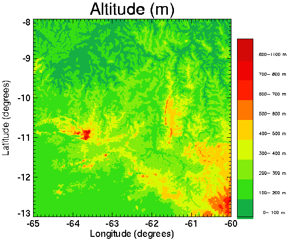
Topography of the Rondonia region (Brazil)
RADAMBRASIL MAPS used: Porto-Velho, Guapore. Paper maps at the millionth scale. Digitized at Meteo-France/CNRM Sept. 1995 Altitude file format (ALTITUDE.txt): The file has a header section which describes the location and size of the data, followed by the data itself. Partial listing of altitude.txt: ncols 600 nrows 600 xllcorner -65 yllcorner -13 cellsize 0.0083333 NODATA_value -9999 100 100 100 100 100 100 100 100 .... First line (Northern line) 600 data |
|
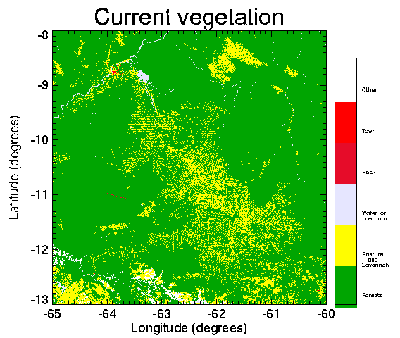
LANDSAT-derived vegetation classification of the Rondonia region (Brazil) in 1993-1994
17 LANDSAT images have been used. Origin of the LANDSAT data: INPE, Sao Jose dos Campos, Brazil. # 6 categories Classification from LANDSAT imagery computed at Meteo-France/CNRM 0: Water 1: Forests (primary or regrowth) 2: Pasture or Savannah 5: Rock 6: Town 7: Other (bogs...) Partial listing of classify.txt: ncols 5000 nrows 5000 xllcorner -65 yllcorner -13 cellsize .001 NODATA_value -9999 1 1 1 1 1 1 1 1 1 1 .......... First line (Northern line) of data |
|
Soil classification of the Rondonia region (Brazil)
RADAMBRASIL MAPS used: Porto-Velho, Guapore. # 133 categories Soil classification maps Porto_velho and Guapore digitized at CNRM/Meteo-France Sept 95 0.00 0.00 0.00 0.00 0: no data 1: LAa1 2: LAa2 3: LAa3 4: LVa1 5: LVa2 6: LVa3 7: LVa4 8: LVa5 9: LVa6 10: LVa7 11: LVa8 12: LVa9 13: LVa10 14: LVa11 15: LVa12 16: TRd1 17: TRd2 18: PE1 19: PE2 20: PE3 21: PE4 22: PVd1 23: PVd2 24: PVd3 25: PVd4 26: PVd5 27: PVd6 28: PVd7 29: PVa1 30: PVa2 31: PVa3 32: PVa4 33: PVa5 34: PVa6 35: PVa7 36: PVa8 37: PVa9 38: PVa10 39: PVa11 40: PVa12 41: PVa13 42: PVa14 43: PVa15 44: PVa16 45: HLa 46: HLra1 47: HLra2 48: HLra3 49: HLra4 50: HP1 51: HP2 52: HP3 53: Cte1 54: Cte2 55: Cte3 56: Cte4 57: Cte5 58: Cta 59: HGPa1 60: HGPa2 61: AQa1 62: AQa2 63: AQa3 64: HAQa1 65: HAQa2 66: Ad 67: Re 68: Rd1 69: Rd2 70: Rd3 71: AR1 72: AR2 73: LAa1 74: LAa2 75: LAa3 76: LAa4 77: LAa5 78: LVa 79: LEd1 80: LEd2 81: BV1 82: BV2 83: TRe 84: PE1 85: PE2 86: PE3 87: PE4 88: PE5 89: PE6 90: PE7 91: PVd1 92: PVd2 93: PVd3 94: PVd4 95: PVd5 96: PVd6 97: PVd7 98: PVd8 99: PVd9 100: HLa1 101: HLa2 102: HLa3 103: HLa4 104: HLa5 105: HLa6 106: Ctd1 107: Ctd2 108: HGPd 109: HGPa1 110: HGPa2 111: HGPa3 112: HGPa4 113: AQd1 114: AQd2 115: AQd3 116: AQd4 117: AQd5 118: AQd6 119: AQd7 120: AQd8 121: AQa1 122: AQa2 123: AQa3 124: Ad 125: Re 126: Rd1 127: Rd2 128: Rd3 129: Rd4 130: Rd5 131: Ra 132: AR 133: aqua Partial file listing of soil.txt: ncols 600 nrows 600 xllcorner -65 yllcorner -13 cellsize 0.0083333 NODATA_value -9999 38 38 38 38 38 38 38 38 .... First line (Northern line) of data |

|
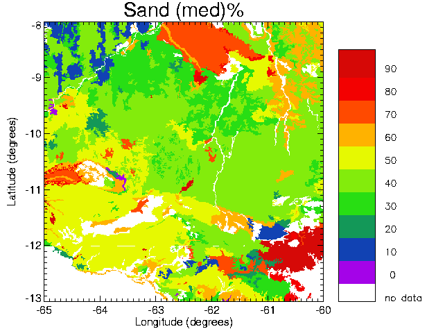
Sand percentage of the Rondonia region (Brazil)
|
|
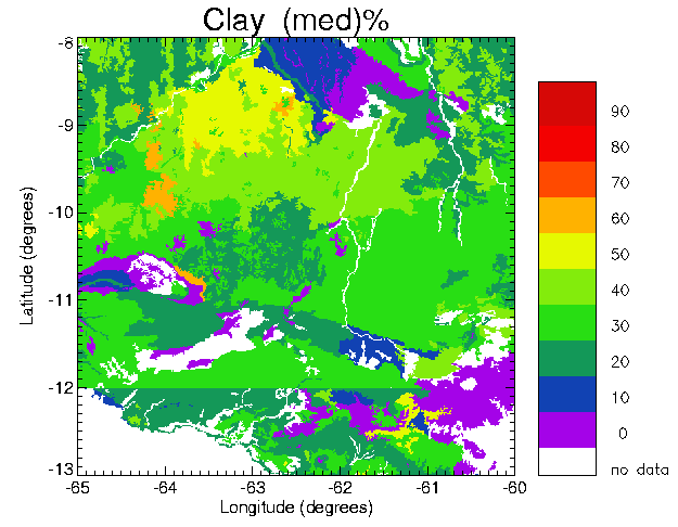
Clay percentage of the Rondonia region (Brazil)
ncols 600 nrows 600 xllcorner -65 yllcorner -13 cellsize 0.0083333 NODATA_value -9999 40 40 40 40 40 40 40 40 40 40 .......... First line (Northern line) of data |
|
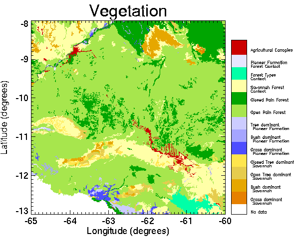
Vegetation classification of the Rondonia region (Brazil) from RADAMBRASIL (1979)
RADAMBRASIL MAPS used: Porto-Velho , Guapore. # 100 categories Vegetation maps Porto_velho and Guapore digitized at CNRM/Meteo_France sept 95 0.00 0.00 0.00 0.00 1: Sad Savana,Arborea densa,Porto velho,Relevo Residual do Sul da Amazonia 2: Sad Savana,Arborea densa,Porto velho,Superficie Pediplanada 3: Sd Savana,Arborea densa,Guapore 4: Saa Savana,Arborea aberta,Porto velho,Relevo Residual do Sul da Amazonia 5: Saa Savana,Arborea aberta,Porto velho,Superficie Pediplanada 6: Sas Savana,Arborea aberta sem floresta de galeria,Guapore 7: Saf Savana,Arborea aberta com floresta de galeria,Guapore 8: Sp Savana,Parque,Porto velho,Relevo Residual do Sul da Amazonia 9: Sp Savana,Parque,Porto velho,Superficie Pediplanada 10: Sps Savana,Parque sem floresta de galeria,Guapore 11: Spf Savana,Parque com floresta de galeria,Guapore 12: Sg Savana,Gramineo-lenhosa,Porto velho,Relevo Residual do Sul da Amazonia 13: Sg Savana,Gramineo-lenhosa,Porto velho,Superficie Pediplanada 14: Sgs Savana,Gramineo-lenhosa sem floresta de galeria,Guapore 15: Sgf Savana,Gramineo-lenhosa com floresta de galeria,Guapore 20: Pap Formacoes Pioneiras,Arborea,areas periodicamente inundadas,Porto velho,Areas de Acumulacao inundaveis 21: Pfb Formacoes Pioneiras,Influencia Fluvial buritizal,Guapore 22: Pau Formacoes Pioneiras,Arbustiva,depressoes periodicamente inundadas,Porto velho,Areas de Acumulacao inundaveis 23: Pau Formacoes Pioneiras,Arbustiva,depressoes periodicamente inundadas,Porto velho,Depressoes nos interfluvios Tabulares do Terciario 24: Pfs Formacoes Pioneiras,Influencia Fluvial arbustiva,sem palmeiras,Guapore 25: Pag Formacoes Pioneiras,Graminosa,areas periodicamente inundadas,Porto velho,Areas de Acumulacao inundaveis 26: Pag Formacoes Pioneiras,Graminosa,areas periodicamente inundadas,Porto velho,Depressoes nos interfluvios Tabulares do Terciario 27: Pfh Formacoes Pioneiras,Influencia Fluvial graminoide,Guapore 30: Fdp Floresta Tropical Densa,Aluvial,planicie periodicamente inundada,Porto velho,Sub-regiao Aluvial da Amazonia 31: Fdc Floresta Tropical Densa,Aluvial,terracos,Porto velho,Sub-regiao Aluvial da Amazonia 32: Fdb Floresta Tropical Densa,Terras baixas,plato,Porto velho,Sub-regiao dos Baixos Platos da Amazonia 33: Fda Floresta Tropical Densa,Terras baixas,relevo dissecado,Porto velho,Sub-regiao dos Baixos Platos da Amazonia 34: Fdo Floresta Tropical Densa,Terras baixas,relevo ondulado,Porto velho,Sub-regiao dos Baixos Platos da Amazonia 35: Fdn Floresta Tropical Densa,Submontana,relevo dissecado,Porto velho,Altos Xingu/Tapajos/Madeira 36: Fds Floresta Tropical Densa,Submontana,relevo ondulado,Porto velho,Altos Xingu/Tapajos/Madeira 37: Fdt Floresta Tropical Densa,Submontana,baixas cadeias de montanhas,Porto velho,Sul da Amazonia 38: Fdr Floresta Tropical Densa,Submontana plato,Porto velho,Cobertura de Plataforma Pre-Cambriana 39: Fdu Floresta Tropical Densa,Submontana relevo dissecado,Porto velho,Cobertura de Plataforma Pre-Cambriana 40: Fdi Floresta Tropical Densa,Submontana relevo ondulado,Porto velho,Cobertura de Plataforma Pre-Cambriana 41: Dae Floresta Ombrofila Densa Tropical,Aluvial,dossel emergente,Guapore 42: Dse Floresta Ombrofila Densa Tropical,Submontana,dossel emergente,Guapore 43: Fap Floresta Tropical Aberta,Aluvial,planicie periodicamente inundada,Porto velho,Sub-regiao Aluvial da Amazonia 44: Fac Floresta Tropical Aberta,Aluvial,terracos,Porto velho,Sub-regiao Aluvial da Amazonia 45: Fal Floresta Tropical Aberta,Aluvial,superficie aplainada,Porto velho,Superficie Aplainada de Acumulacao 46: Fab Floresta Tropical Aberta,Terras baixas,plato,Porto velho,Sub-regiao dos Baixos Platos da Amazonia 47: Faa Floresta Tropical Aberta,Terras baixas,relevo dissecado,Porto velho,Sub-regiao dos Baixos Platos da Amazonia 48: Fao Floresta Tropical Aberta,Terras baixas,relevo ondulado,Porto velho,Sub-regiao dos Baixos Platos da Amazonia 49: Fan Floresta Tropical Aberta,Submontana,relevo dissecado,Porto velho,Altos Xingu/Tapajos/Madeira 50: Fas Floresta Tropical Aberta,Submontana,relevo ondulado,Porto velho,Altos Xingu/Tapajos/Madeira 51: Far Floresta Tropical Aberta,Submontana plato,Porto velho,Cobertura de Plataforma Pre-Cambriana 52: Fau Floresta Tropical Aberta,Submontana relevo dissecado,Porto velho,Cobertura de Plataforma Pre-Cambriana 53: Fai Floresta Tropical Aberta,Submontana relevo ondulado,Porto velho,Cobertura de Plataforma Pre-Cambriana 54: Abc Floresta Ombrofila Aberta Tropical,Terras Baixas com cipos,Guapore 55: Abp Floresta Ombrofila Aberta Tropical,Terras Baixas com palmeiras,Guapore 56: Asc Floresta Ombrofila Aberta Tropical,Submontana com cipos,Guapore 57: Asp Floresta Ombrofila Aberta Tropical,Submontana com palmeiras,Guapore 58: Fae Floresta estacional Semidecidual Tropical,Aluvial dossel emergente,Guapore 59: Fbe Floresta estacional Semidecidual Tropical,Terras Baixas dossel emergente,Guapore 60: Fse Floresta estacional Semidecidual Tropical, Submontana dossel emergente,Guapore 61: Sad Conatato Savana/Floresta,Savana Arbores densa,Porto velho 62: Sd2 Contato Savana/Floresta Estacional,Savana, Arborea densa,Guapore 63: Saa Contato Savana/Floresta,Savana Arbores aberta,Porto velho 64: Sas2 Contato Savana/Floresta Estacional,Savana, Arborea Aberta sem floresta de galeria,Guapore 65: Saf2 Contato Savana/Floresta Estacional,Savana, Arborea Aberta com floresta de galeria,Guapore 66: Sp Contato Savana/Floresta,Savana Parque,Porto velho 67: STe3 Contato Savana/Savana Estepica,Ecotono,Guapore 68: FSm Contato Savana/Floresta,Ecotono,Porto velho 69: SNe2 Contato Savana/Floresta Estacional,Ecotono,Guapore 70: Fbe2 Contato Savana/Floresta Estacional,Floresta Semidecidual,Guapore,Terras Baixas dossel emergente 71: Fse2 Contato Savana/Floresta Estacional,Floresta Semidecidual,Guapore,Submontana dossel emergente 72: SOe1 Contato Savana/Floresta Ombrofila, Ecotono,Guapore 73: Abc1 Contato Savana/Floresta Ombrofila, Floresta aberta,Guapore,Terras Baixas com cipos 74: Asc1 Contato Savana/Floresta Ombrofila, Floresta aberta,Guapore,Submontana com cipos 75: Fac Contato Savana/Floresta,Floresta Tropical Aberta,Aluvial,terracos,Porto velho,Sub-regiao Aluvial da Amazonia 76: Fab Contato Savana/Floresta,Floresta Tropical Aberta,Terras baixas,plato,Porto velho,Sub-regiao dos Baixos Platos da Amazonia 77: Fao Contato Savana/Floresta,Floresta Tropical Aberta,Terras baixas,relevo ondulado,Porto velho,Sub-regiao dos Baixos latos da Amazonia 78: Fan Contato Savana/Floresta,Floresta Tropical Aberta,Submontana,relevo dissecado,Porto velho, Altos Xingu/Tapajos/Madeira 79: Fas Contato Savana/Floresta,Floresta Tropical Aberta,Submontana,relevo ondulado,Porto velho,Altos Xingu/Tapajos/Madeira 80: Far Contato Savana/Floresta,Floresta Tropical Aberta,Submontana plato,Porto velho,Cobertura de Plataforma Pre-Cambriana 81: Fau Contato Savana/Floresta,Floresta Tropical Aberta,Submontana relevo dissecado,Porto velho,Cobertura de Plataforma Pre-Cambriana 82: Fai Contato Savana/Floresta,Floresta Tropical Aberta,Submontana relevo ondulado,Porto velho,Cobertura de Plataforma Pre-Cambriana 83: Fdr Contato Savana/Floresta,Floresta densa,Submontana plato,Porto velho 84: Fdu Contato Savana/Floresta,Floresta densa,Submontana relevo dissecado,Porto velho 85: Fdi Contato Savana/Floresta,Floresta densa,Submontana relevo ondulado,Porto velho 86: Cbe4 Contato Savana Estepica/Floresta Estacional,Floresta Decidual,Guapore,Terras Baixas dossel emergente 87: Fbe5 Contato Floresta Ombrofila/Floresta Estacional,Floresta Semidecidual,Guapore,Terras Baixas dossel emergente 88: Fse5 Contato Floresta Ombrofila/Floresta Estacional,Floresta Semidecidual,Guapore,Submontana dossel emergente 89: ONe5 Contato Floresta Ombrofila/Floresta Estacional,Ecotono,Guapore 90: Pap Contato Formacoes Edaficas/Floresta,Arborea,Porto velho,areas periodicamente inundadas 91: Fdp Contato Formacoes Edaficas/Floresta,Floresta Tropical Densa,Porto velho,Aluvial planicie,Sub-regiao Aluvial da Amazonia 92: Fdc Contato Formacoes Edaficas/Floresta,Floresta Tropical Densa,Porto velho,Aluvial terracos,Sub-regiao Aluvial da Amazonia 93: Fap Contato Formacoes Edaficas/Floresta,Floresta Tropical Aberta,Porto velho,Aluvial planicie,Sub-regiao Aluvial da Amazonia 94: Fac Contato Formacoes Edaficas/Floresta,Floresta Tropical Aberta,Porto velho,Aluvial terracos 95: Fag Contato Formacoes Edaficas/Floresta,Floresta Tropical Aberta,Porto velho,Aluvial planicie 96: Fao Contato Formacoes Edaficas/Floresta,Floresta Tropical Aberta,Porto velho,Terras baixas,relevo ondulado 99: Water 100: Ap Agropecuaria Partial listing of vegetation.txt: ncols 600 nrows 600 xllcorner -65 yllcorner -13 cellsize 0.0083333 46 46 46 0 0 0 0 0 .... First line (Northern line) of data |
References
Santos Alvala, R.C., J.C. Calvet, G. Jaubert, J. Noilhan, I.R. Wright, 1996: Mapping surface parameters for mesoscale modeling in forested and deforested South-Western Amazonia. Note de Centre, No. 40, Janvier 1996, Centre National de Recherches Meteorologiques - CNRM, METEO FRANCE, TOULOUSE CEDEX, France.
Calvet, J.C., Regina C. Santos Alvala, Genevieve Jaubert, Christine Delire,
Carlos A. Nobre, Ivan Wright and Joel Noilhan, 1996:
Mapping surface parameters
for mesoscale modeling in forested and deforested South-Western Amazonia.
Bulletin of the American Meteorological Society, Vol. 78, No. 3, March 1997.
Macedo, E. L. da R. et al. Levantamento exploratorio de solos. In: BRASIL, Departamento Nacional de Producao Mineral, Projeto RADAMBRASIL. Folha SD.20 - Guapore; geologia, geomorfologia, solos, vegetacao, uso potencial da terra. Rio de Janeiro, 1979. p.165-260.
Data Access:
This data is available through the Oak Ridge National Laboratory (ORNL) Distributed Active Archive Center (DAAC) [http: //daac.ornl.gov].
Data Archive Center:
Contact for Data Center Access Information:
E-mail:
uso@daac.ornl.gov
Telephone:
+1 (865) 241-3952