Documentation Revision Date: 2021-09-07
Dataset Version: 1
Summary
Example clients are provided on the MODIS Web Service page. Please refer to: https://modis.ornl.gov/data/modis_webservice.html.
Related MODIS Tools:
How to Cite MODIS Web Service Data:
Please refer to Section 5 of this document and to the MODIS Citation Guidelines page for more information on how to cite data obtained through the MODIS Web Service.
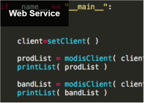
Figure 1. Users may access data through the MODIS Web Service for any land location on earth.
Citation
ORNL DAAC. 2018. MODIS Collection 6 Land Product Subsets Web Service. ORNL DAAC, Oak Ridge, Tennessee, USA. https://doi.org/10.3334/ORNLDAAC/1557
Table of Contents
- Dataset Overview
- Data Characteristics
- Application and Derivation
- Quality Assessment
- Data Acquisition, Materials, and Methods
- Data Access
- References
- Dataset Revisions
Dataset Overview
The MODIS Web Service provides data access capabilities for Moderate Resolution Imaging Spectroradiometer (MODIS) Collection 6 land products. The web service provides data access functions for users to execute on their local computing resources. Available functions are listed in Table 1 below. The MODIS Web Service is built upon the ORNL DAAC's MODIS Global Subsetting and Visualization Tool that provides customized subsets and visualization of MODIS land products for any land location on earth.
With the web service users can retrieve land product subsets through command line operations; download subsets directly into applications such as Python, R, Perl, Matlab, and others and integrate the subsets into client side workflows; download subsets and write custom code to use the subsets in a visualization; and download subsets and write custom code for data reformatting.
Data Characteristics
The data products available through the MODIS Web Service are generated by the MODIS instruments flown on NASA's Terra and Aqua satellites. Terra products are available from February 2000 to present and Aqua products are available from June 2002 to present. They are available for daily, 4-day, 8-day, 16-day, and annual composite periods at 250-m, 500-m, or 1-km resolution, depending on the product.
Please refer to the MODIS Documentation page for a list of available Collection 6 land products.
Application and Derivation
The MODIS web service streamlines the use of MODIS data for characterization of field sites, validation of models and other remote sensing products, and other research activities.
Quality Assessment
The results of routine quality assessments are maintained at the MODIS Land Quality Assessment (MODLAND) site by the MODIS Land Science Team and provided through product metadata and per-pixel information for each MODIS granule.
Data Acquisition, Materials, and Methods
Data Processing
MODIS tiles are provided to the ORNL DAAC by the Land Processes DAAC (LP DAAC). The ORNL DAAC creates subsets and packages the data for research applications.
Citing Data Obtained via the MODIS Web Service
Citation Format:
ORNL DAAC. 2017. MODIS Collection 6 Land Products Web Service. ORNL DAAC, Oak Ridge, Tennessee, USA. Accessed Month dd, yyyy. Subset obtained for [Product name] product at [Lat],[Lon], time period: [Start date] to [End date], and subset size: [Width] x [Height] km. https://dx.doi.org/10.3334/ORNLDAAC/1557
Citation Example for a Single MODIS Product:
ORNL DAAC. 2017. MODIS Collection 6 Land Product Subsets Web Service. ORNL DAAC, Oak Ridge, Tennessee, USA. Accessed July 24, 2017. Subset obtained for MOD13Q1 product at 35.9587N, 84.2874W, time period: 2000-02-18 to 2000-04-06, and subset size: 0.25 x 0.25 km. https://dx.doi.org/10.3334/ORNLDAAC/1557
Generic Citation Example for the MODIS Web Service: (When data for many products and sites are used, please cite the MODIS Web Service tool itself)
ORNL DAAC. 2017. MODIS Collection 6 Land Product Subsets Web Service. ORNL DAAC, Oak Ridge, Tennessee, USA. Accessed July 24, 2017. Products obtained using the MODIS Web Service tool. https://dx.doi.org/10.3334/ORNLDAAC/1557
Refer to the ORNL DAAC Data Citation Guidelines for additional information.
Tool Description
The MODIS Web Service provides data access capabilities for Moderate Resolution Imaging Spectroradiometer (MODIS) Collection 6 land products. The web service provides data access functions for users to execute on their local computing resources. Available functions are listed in Table 1.
With the web service users can retrieve land product subsets through command line operations; download and integrate subsets directly into client side workflows; download and visualize subsets with customized code; and download subsets and write custom code for data reformatting.
Table 1. Available MODIS Web Service functions
| Function (Example Request) | Input | Output |
|---|---|---|
| getproducts() | NONE | This returns the list of products available. Product shortname is used. Example: MOD11A2, MOD13Q1, MOD09A1.. |
| getbands("MOD13Q1") | Product | This returns the list of bands available for a product. Example: 250m_16_days_NDVI,250m_16_days_EVI,.. |
| getdates(40, -110, "MOD13Q1") | Latitude, Longitude, Product | This returns the list of composite dates available for the product, Latitude, Longitude combination. Example: A2000065, A2000081, A2000097, A2000113.... |
| getsubset(40, -110, "MOD13Q1", "250m_16_days_NDVI", "A2000065", "A20000081", 10, 10) | Latitude,Longitude, Product, Band, MODIS Subset Start Date, MODIS Subset End Date, Km Above Below, Km Left Right | This returns the subset in ASCII format for the location, product, band and date combination with detailed projection and band information. Example: MOD13Q1.A2000065.h09v04.006.2008238050507.250m_16_days_NDVI, MOD13Q1, A2000065, Lat40.0Lon-110.0Samp21Line21, 2008238050507, 1177, 1164, 1116, 1198, 1256, 1226, 1177, 1154, 1267, 1348, 1277, 1345, 1411, 1341, 1278, 1217, 1232, 1244, 1262, ... |
| getsubsetorder(40.1, -110.2, "MOD13Q1", "santhanavans@ornl.gov", "data", "A2000065", "A20000081", 10, 10) Note: This function is in beta | Latitude, Longitude, Product, Email ID, Order ID, MODIS Subset Start Date, MODIS Subset End Date, Km Above Below, Km Left Right | This returns a Unique ID for the subset order. Example: 24May2010_15:54:58_416294117L40.1L-110.2S81L81_MOD13Q1_data |
Data Delivery:
The MODIS Web Service is used to retrieve subset data in real-time for any location and time period. It is built upon the same backend processes used to deliver orders requested through the MODIS Global Subsetting and Visualization Tool. MODIS Web Service clients and libraries are available in multiple programming languages, allowing integration of subsets into user workflows.
MODIS Web Service Setup:
To aid users with setting up the web service, example clients are provided at the MODIS Web Service page: https://modis.ornl.gov/data/modis_webservice.html.
Data Access
These data are available through the Oak Ridge National Laboratory (ORNL) Distributed Active Archive Center (DAAC).
MODIS Collection 6 Land Product Subsets Web Service
Contact for Data Center Access Information:
- E-mail: uso@daac.ornl.gov
- Telephone: +1 (865) 241-3952
References
S.K. Santhana Vannan, R.B. Cook, J.Y. Pan, B.E. Wilson. A SOAP Web Service for accessing MODIS land product subsets (2011). Earth Science Informatics. DOI:10.1007/s12145-011-0079-2
S.K. Santhana Vannan, R.B. Cook, S.K. Holladay, L.M. Olsen, U. Dadi, B.E. Wilson. A Web-Based Subsetting Service for Regional Scale MODIS Land Products (2010). IEEE JSTARS, 2(4): 319–328
Dataset Revisions
The Simple Object Access Protocol (SOAP) service has been discontinued and replaced with Representational State Transfer (REST) services. Please refer to https://doi.org/10.3334/ORNLDAAC/1600 , MODIS and VIIRS Land Products Subsets RESTful Web Service.