Documentation Revision Date: 2021-09-20
Dataset Version: 1
Summary
UAVSAR is a polarimetric L-band synthetic aperture radar (SAR) flown on the NASA Gulfstream-3 aircraft. Channel maps were generated from the InSAR interferograms for nearest-neighbor (NN), NN+1, and NN+2 pairs for data acquired on 2016-10-16 (low tide) and 2016-10-17 (high tide).
There are two files in geoTIFF (*.tif) format.
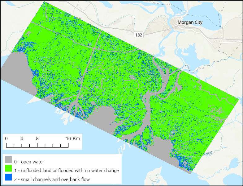
Figure 1. Water channels (blue) in the Atchafalaya Basin of the Mississippi River Delta of coastal Louisiana, U.S., during low tide on October 16, 2016. Source: PreDeltaX_channels_161016_lowtide_01.tif
Citation
Jones, C., T. Oliver, and Y. Lou. 2021. Pre-Delta-X: UAVSAR Georeferenced Channel Maps, Atchafalaya Basin, LA, USA, 2016. ORNL DAAC, Oak Ridge, Tennessee, USA. https://doi.org/10.3334/ORNLDAAC/1954
Table of Contents
- Dataset Overview
- Data Characteristics
- Application and Derivation
- Quality Assessment
- Data Acquisition, Materials, and Methods
- Data Access
- References
Dataset Overview
This dataset provides spatial data on water channels in the estuary of the Atchafalaya Basin of the Mississippi River Delta of coastal Louisiana. These Level-3 (L3) channel maps were developed from interferograms derived from Uninhabited Aerial Vehicle Synthetic Aperture Radar (UAVSAR) data collected on 2016-10-16 and 2016-10-17 during low and high tides. The channel maps define open water paths in hydrodynamic models and are used to evaluate model performance.
UAVSAR is a polarimetric L-band synthetic aperture radar (SAR) flown on the NASA Gulfstream-3 aircraft. Channel maps were generated from the InSAR interferograms for nearest-neighbor (NN), NN+1, and NN+2 pairs for data acquired on 2016-10-16 (low tide) and 2016-10-17 (high tide).
Project: Delta-X
The Delta-X mission is a 5-year NASA Earth Venture Suborbital-3 mission to study the Mississippi River Delta in the United States, which is growing and sinking in different areas. River deltas and their wetlands are drowning as a result of sea level rise and reduced sediment inputs. The Delta-X mission will determine which parts will survive and continue to grow, and which parts will be lost. Delta-X begins with airborne and in situ data acquisition and carries through data analysis, model integration, and validation to predict the extent and spatial patterns of future deltaic land loss or gain.
Related Publication
Jensen, D., K.C. Cavanaugh, M. Simard, G.S. Okin, E. Castañeda-Moya, A. McCall, and R.R. Twilley. 2019. Integrating imaging spectrometer and synthetic aperture radar data for estimating wetland vegetation aboveground biomass in coastal Louisiana. Remote Sensing 11(21):2533. https://doi.org/10.3390/rs11212533
Related Datasets
Jones, C., M. Simard, Y. Lou, and T. Oliver. 2021. Pre-Delta-X: L1 UAVSAR Single Look Complex and Interferograms, MRD, LA, USA, 2016. ORNL DAAC, Oak Ridge, Tennessee, USA. https://doi.org/10.3334/ORNLDAAC/1816
- The single look complex (SLC) stack product is a standard UAVSAR product delivered by the UAVSAR processing team. The L1 interferograms were generated from the SLC stacks.
Jones, C., M. Simard, and Y. Lou. 2021. Pre-Delta-X: UAVSAR-derived Water Level Change Maps, Atchafalaya Basin, LA, USA, 2016. ORNL DAAC, Oak Ridge, Tennessee, USA. https://doi.org/10.3334/ORNLDAAC/1823
- This, and the current dataset, are Pre-Delta-X UAVSAR derived datasets characterizing water levels in the Atchafalaya Basin.
Acknowledgments
This work was supported by Jet Propulsion Laboratory Research and Technology Development (JPL-R&TD) FY17–19 (grants 01STCR / R.17.231.069).
Data Characteristics
Spatial Coverage: Atchafalaya Basin, Mississippi River Delta (MRD), southern coast of Louisiana, USA
Spatial Resolution: 0.000055 degrees (approximately 5.5 m)
Temporal Coverage: 2016-10-16 to 2016-10-17
Temporal Resolution: Two daily estimates
Site Boundaries: Latitude and longitude are given in decimal degrees.
| Site | Westernmost Longitude | Easternmost Longitude | Northernmost Latitude | Southernmost Latitude |
|---|---|---|---|---|
| Atchafalaya Basin | -91.6221 | -91.0576 | 29.7584 | 29.3561 |
Data File Information
There are two data files in geoTiFF (*.tif) format, which include the location of water channels, land, and open water during low and high tides.
Table 1. File names and descriptions.
| File Name | Description |
|---|---|
| PreDeltaX_channels_161016_lowtide_01.tif | Channels and flooded lands during low tide. Raw data acquired 2016-10-16 14:08:00 to 2016-10-16 16:37:00 UTC. |
| PreDeltaX_channels_161017_hightide_01.tif | Channels and flooded lands during high tide. Raw data acquired 2016-10-17 19:37:00 to 2016-10-17 21:51:00 UTC. |
Data File Details
- The datatype is Int16
- Spatial reference system: WGS 84 (EPSG:4326)
- The pixel size is 5.556 x 10⁻⁵ decimal degrees (~5.5 m)
- There are 7239 rows and 10161 columns
Table 2. Categorical values describing the locations provided in the data files.
| Value | Description |
|---|---|
| 0 | Open water |
| 1 | Unflooded land or flooded land without measurable water level change |
| 2 | Small channels and overbank flow that occurred during the imaging time period |
| -99 | No data, where no imagery was acquired |
Application and Derivation
Water surface elevation, land, and vegetation features were measured using UAVSAR, a synthetic aperture radar instrument. The UAVSAR data were used to measure hydrological parameters, and the L3 water channel maps served to define the open water paths in hydrodynamic models and to evaluate model performance.
Quality Assessment
Data quality of the channel map product was assessed through comparison with maps derived from optical imagery and with visual comparisons to Google Earth. In all products, pixels that lack data or for which the data fail quality tests will use the no data value.
Data Acquisition, Materials, and Methods
UAVSAR is a polarimetric L-band synthetic aperture radar operating with 80 MHz bandwidth from 1217.5–1297.5 GHz designed for interferometry (InSAR) (Hensley et al., 2009). UAVSAR’s swath width is 22 km, which illuminates an area from ~22°–67° incidence angle, with 3 m (cross-track average) by 1 m (along-track) single look ground resolution. The instrument is flown on a Gulfstream-III (C20) aircraft, with the radar electronics and antenna housed in a pod mounted below the fuselage (Fig. 2).
During the Pre-Delta-X campaign, the UAVSAR instrument was operated in its standard acquisition configuration, flown at an altitude of 12.5 km in quad-polarization mode, transmitting horizontally and vertically polarized radiation on alternate pulses and receiving both co-polarized (HH or VV) and cross-polarized (HV or VH) returns for each pulse.
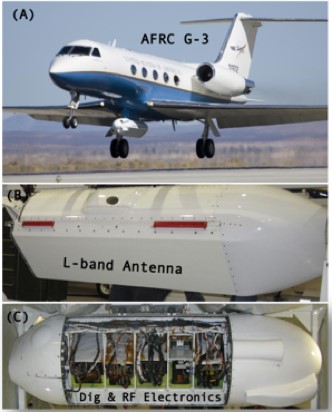
Figure 2. UAVSAR is flown on a Gulfstream-III aircraft, mounted in a pod hung below the fuselage.
The UAVSAR was flow over the gulfco_12011 flight line on 2016-10-16 14:08 UTC at low tide and on 2016-10-17 19:37 UTC at high tide (Fig. 3). Each time, the flight covered the study area six times at approximately 30-minute intervals and collected images on each pass. These images, the Level-1 UAVSAR SLC HH_polarization coregisted stack product for flightline 12011 (SLC product name gulfco_12011_01; Jones et al., 2021) were used to generate wrapped InSAR interferograms and interferometric coherence products for nearest-neighbor (NN), NN+1, and NN+2 pairs for low-tide and high-tide periods. These products were further interpreted to generate the channel maps.
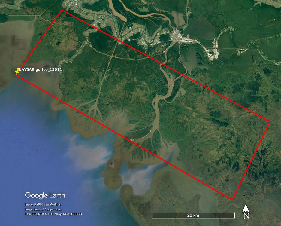
Figure 3. The spatial coverage of UAVSAR flight line gulfco_12011 flown on October 16-17 2016, over the Mississippi River Delta in coastal Louisiana, USA.
Data Access
These data are available through the Oak Ridge National Laboratory (ORNL) Distributed Active Archive Center (DAAC).
Pre-Delta-X: UAVSAR Georeferenced Channel Maps, Atchafalaya Basin, LA, USA, 2016
Contact for Data Center Access Information:
- E-mail: uso@daac.ornl.gov
- Telephone: +1 (865) 241-3952
References
Hensley, S., H. Zebker, C. Jones, T. Michel, R. Muellerschoen, and B. Chapman. 2009. First deformation results using the NASA/JPL UAVSAR instrument. 2009 2nd Asian-Pacific Conference on Synthetic Aperture Radar. https://doi.org/10.1109/APSAR.2009.5374246
Jones, C., M. Simard, Y. Lou, and T. Oliver. 2021. Pre-Delta-X: L1 UAVSAR Single Look Complex and Interferograms, MRD, LA, USA, 2016. ORNL DAAC, Oak Ridge, Tennessee, USA. https://doi.org/10.3334/ORNLDAAC/1816