Documentation Revision Date: 2022-09-23
Dataset Version: 2
Summary
This dataset includes 771 files in comma-separated values (*.csv) format and 2 files in compressed Keyhole Markup Language (*.kmz) format.
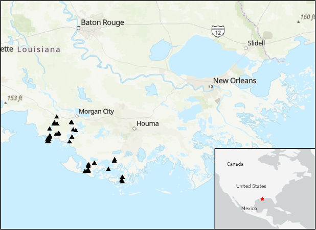
Figure 1. Locations of river discharge measurements (black triangles) in the Atchafalaya and Terrebonne Basins within the Mississippi River Delta (MRD) floodplain in coastal Louisiana, U.S. Measurements were taken by Delta-X project in March and April 2021. Source: DeltaX_RiverDischarge_Spring2021.csv
Citation
Christensen, A.L., J.M. Mallard, J. Nghiem, M. Simard, T.M. Pavelsky, and M.P. Lamb. 2022. Delta-X: Acoustic Doppler Current Profiler Channel Surveys, MRD, Louisiana, 2021, V2. ORNL DAAC, Oak Ridge, Tennessee, USA. https://doi.org/10.3334/ORNLDAAC/2081
Table of Contents
- Dataset Overview
- Data Characteristics
- Application and Derivation
- Quality Assessment
- Data Acquisition, Materials, and Methods
- Data Access
- References
- Dataset Revisions
Dataset Overview
This dataset provides river discharge measurements collected at selected locations in the Atchafalaya and Terrebonne Basins within the Mississippi River Delta (MRD) floodplain in coastal Louisiana, USA. The measurements were made during the Delta-X 2021 field efforts from 2021-03-25 to 2021-04-11 (spring) and 2021-08-16 to 2021-09-25 (fall). Channel surveys were conducted with a Teledyne RiverPro acoustic doppler current profiler (ADCP) or a Sontek M9 RiverSurveyor ADCP on selected wide channels (>100 m wide) and a few selected narrow channels (approximately 10 m wide) near the Delta-X intensive study sites. River discharge was measured on cross-channel transects. Reported data include bathymetry, discharge (m3 s-1), and flow velocity.
Project: Delta-X
The Delta-X mission is a 5-year NASA Earth Venture Suborbital-3 mission to study the Mississippi River Delta in the United States, which is growing and sinking in different areas. River deltas and their wetlands are drowning as a result of sea level rise and reduced sediment inputs. The Delta-X mission will determine which parts will survive and continue to grow, and which parts will be lost. Delta-X begins with airborne and in-situ data acquisition and carries through data analysis, model integration, and validation to predict the extent and spatial patterns of future deltaic land loss or gain.
Related Datasets
Christensen, A.I., T.M. Pavelsky, D.J. Jensen, and K. Liu. 2020. Pre-Delta-X: River Discharge Channel Surveys across Atchafalaya Basin, LA, USA, 2016. ORNL DAAC, Oak Ridge, Tennessee, USA. https://doi.org/10.3334/ORNLDAAC/1806
- The preliminary dataset that lead to the formation of the current dataset.
Denbina, M.W., M. Simard, T.M. Pavelsky, A.I. Christensen, K. Liu, and C. Lyon. 2020. Pre-Delta-X: Channel Bathymetry of the Atchafalaya Basin, LA, USA, 2016. ORNL DAAC, Oak Ridge, Tennessee, USA. https://doi.org/10.3334/ORNLDAAC/1807
Denbina, M.W., M. Simard, E. Rodriguez, X. Wu, and C. Michailovsky. 2021. Pre-Delta-X: L3 AirSWOT-derived Water Level Profiles, Wax Lake Outlet, LA, USA, 2015. ORNL DAAC, Oak Ridge, Tennessee, USA. https://doi.org/10.3334/ORNLDAAC/1819
Acknowledgement
This work was supported by NASA Earth Venture Suborbital-3 Program (grant NNH17ZDA001N-EVS3: Delta-X) and Research and Technology Development at NASA's Jet Propulsion Laboratory (Strategic R&TD FY17–19).
Data Characteristics
Spatial Coverage: Atchafalaya and Terrebonne Basins, Mississippi River Delta (MRD) floodplain, southern coast of Louisiana, USA
Spatial Resolution: Point samples
Temporal Coverage: 2021-03-25 to 2021-04-11 (spring) and 2021-08-16 to 2021-09-25 (fall)
Temporal Resolution: One-time estimates
Site Boundaries: Latitude and longitude are given in decimal degrees.
| Site | Westernmost Longitude | Easternmost Longitude | Northernmost Latitude | Southernmost Latitude |
|---|---|---|---|---|
| Atchafalaya and Terrebonne Basins | -91.4522 | -90.6740 | 29.7040 | 29.1575 |
Data File Information
This dataset includes 771 files in comma-separated values (CSV, *.csv) format and 2 file in compressed Keyhole Markup Language (KMZ, *.kmz) format.
The two KMZ files illustrate the sampling locations for all ADCP transects (points mark an edge of each transect): DeltaX_RiverDischarge_sites_Fall2021.kmz and DeltaX_RiverDischarge_sites_Spring2021.kmz.
Two CSV files hold summary information compiled for all transects: DeltaX_RiverDischarge_Fall2021.csv and DeltaX_RiverDischarge_Spring2021.csv
Most CSV files hold instrument data and use the naming convention:
ADCP_YYYYMMDD-hhmmss_AAA_BBB_CCC_RepD_EEEE.csv, where
- YYYYMMDD = date as year, month (MM), and day (DD),
- hhmmss = time of arrival to site in hour (hh), minute (mm), and second (ss) in UTC,
- AAA = location name,
- BBB = site name,
- CCC = transect number, and
- D = replicate number, and
- EEEE = "Bathy" or "Velocity", indicated bathymetry or flow velocity data, respectively.
User Note: These instrument files should be considered raw data. Some files are missing longitude-latitude coordinates; however, transect coordinates are available from summary files in the planned_latitude and planned_longitude fields.
Table 1. File names and descriptions.
| File Name | Description |
|---|---|
| Data Files | |
| ADCP_YYYYMMDD_hhmmss_AAA_BBB_CCC_RepD_Bathy.csv | Bathymetry data from individual transects. These files should be considered raw data. Some files are missing longitude-latitude coordinates; however, transect coordinates are available from DeltaX_RiverDischarge_Spring2021.csv or DeltaX_RiverDischarge_Fall2021.csv in the planned_latitude and planned_longitude fields. |
| ADCP_YYYYMMDD_hhmmss_AAA_BBB_CCC_RepD_Velocity.csv |
Flow velocity data from individual transects, including flow velocity and flow direction at various depths. These files should be considered raw data. Each row represents one velocity component of one vertical section of a particular point along the ADCP transect. Therefore, to reconstruct the vertical profile at one point along the ADCP transect, users must combine all rows with the same ensemble number. |
| DeltaX_RiverDischarge_Spring2021.csv, DeltaX_RiverDischarge_Fall2021.csv |
Summary information for each channel transect including longitude-latitude coordinates and discharge for each transect. |
| DeltaX_RiverDischarge_sites_Spring2021.kmz, DeltaX_RiverDischarge_sites_Fall2021.kmz |
Provides transect locations viewable in Google Earth. |
| DeltaX_ADCP_Measurements.pdf | A PDF version of this user guide. |
Data File Details
The files contain location coordinates in longitude, latitude (EPSG: 4326).
Missing text data are indicated by NaN, and missing numeric data are indicated by the value -9999.
Table 2. Variables in the summary files DeltaX_RiverDischarge_Spring2021.csv and DeltaX_RiverDischarge_Fall2021.csv.
| Variable | Units | Description | Collected During Pre-Delta-X Campaign? |
|---|---|---|---|
| profiler_id | text | Instrument used: "Sontek RiverSurveyor M9" or "Teledyne RiverPro" | Yes |
| team | text | Name of team that collected data | No |
| basin | text | Name of estuary basin: “Atchafalaya” or “Terrebonne” | Yes |
| campaign | text | Campaign name: "Spring 2016" or "Fall 2016" | Yes |
| filename | text | Name of raw data file for bathymetry or velocity readings. | Yes |
| transect | 1 | Order number of transect at a site | Yes |
| location | text | General location of transect (e.g. ATCH, ICWW, FLB) | No |
| site_name | text | Name of site | No |
| replicate | 1 | The replicate number for given transect | No |
| planned_latitude | degree_north | Planned location of transect | Yes |
| planned_longitude | degree_east | Planned location of transect | Yes |
| start_date | YYYY-MM-DD | Start date of the transect in year (YYYY), month (MM), and day (DD) | Yes |
| start_time | hh:mm:ss | Start time of the transect in hour (hh), minute (mm), second (ss) UTC | Yes |
| start_ensemble | 1 | The first ensemble included in the transect | No |
| start_latitude | degree_north | Location of transect start. ‘-9999’ values indicate no valid GPS data available | Yes |
| start_longitude | degree_east | Location of transect start. ‘-9999’ values indicate no valid GPS data available | Yes |
| end_date | YYYYMMDD | End date of the transect in year (YYYY), month (MM), day (DD) | No |
| end_time | hh:mm:ss | End time of the transect in UTC | No |
| end_ensemble | 1 | The last ensemble included in the transect | No |
| end_latitude | degree_north | Location of transect end. ‘-9999’ values indicate no valid GPS data available | No |
| end_longitude | degree_east | Location of transect end. ‘-9999’ values indicate no valid GPS data available | No |
| width | m | Width of the channel | Yes |
| area | m2 | Area of the channel | Yes |
| boat_speed | m s-1 | Average boat speed during the transect | Yes |
| mean_speed | m s-1 | Average water speed during the transect | Yes |
| discharge_side | m3 s-1 | Sum of discharge on the left and right edges of the transect | Yes |
| discharge_top | m3 s-1 | Discharge in the top portion of the transect | Yes |
| discharge_middle | m3 s-1 | Discharge in the middle portion of the transect | Yes |
| discharge_bottom | m3 s-1 | Discharge in the bottom portion of the transect | Yes |
| discharge_total | m3 s-1 | Total discharge | Yes |
| flow_direction | degree | Azimuth direction of water flow. Degrees from north, clockwise. | No |
| notes | text | Notes regarding data collection | No |
| mount_type | text | Method for mounting instrument to boat: boat bow, boat port, hydroboard, and ADCP float |
Table 3. Variables in files named ADCP_YYYYMMDD_hhmmss_AAA_BBB_CCC_RepD_Bathy.csv.
| Variable | Units | Description |
|---|---|---|
| ensemble | 1 | Ensemble number |
| date | YYYY-MM-DD | Date of the transect in year (YYYY), month (MM), and day (DD) |
| time | hh:mm:ss | Time of the ensemble in hour (hh), minute (mm), second (ss) UTC |
| distance_traveled | m | Distance traveled since the beginning of the transect |
| river_depth | m | Measured river depth |
| latitude | degree_north | Location of transect start. ‘-9999’ values indicate no valid GPS data available |
| longitude | degree_east | Location of transect start. '-9999’ values indicate no valid GPS data available |
| bin_width | m | The horizontal length of the bin represented by the ensemble number. Values of -9999 indicate that bin_width was not calculated due to GPS problems. |
Table 4. Variables in files named ADCP_YYYYMMDD_hhmmss_AAA_BBB_CCC_RepD_Velocity.csv.
| Variable | Units | Description |
|---|---|---|
| ensemble | 1 | Ensemble number |
| upper_depth | m | Upper depth of measurement cell |
| lower_depth | m | Lower depth of cell |
| velocity_component | text | The velocity component: "easting", "northing", "vertical" |
| flow_velocity | m s-1 | The flow velocity of that cell in the given direction |
Application and Derivation
Understanding and mitigating the impact of the relative sea-level rise on coastal deltas is an urgent concern. If ignored, sea-level rise will very soon have devastating consequences on the livelihood of the half-billion people that live in these low-lying coastal regions. Estuarine wetlands provide protection from storms and confer some resilience in the face of environmental change. Therefore, understanding the processes that control the location, extent, and topography of these ecosystems is essential.
This dataset is used to calibrate and validate Delta-X’s hydrodynamic models. Acoustic doppler current profiler (ADCP) data provide near-instantaneous estimates of river discharge across the sampled channels at particular times. These locations and time-specific measurements are compared to hydrodynamic models to calibrate and validate their parameters. The hydrology models quantify the mesoscale (i.e., 1 ha) patterns of soil accretion that control land loss and gain (Simard et al., 2017), and they predict the resilience of deltaic floodplains under projected sea-level rise.
Quality Assessment
Two or more replicate transects were taken and compared at each site. Transects were inspected for data loss due to instrument communication issues, and transects with lost data were removed. The goal was for measured discharge of replicates to differ by no more than 5%. This standard was met in most cases, except where flow rate was very small. Replicate transects are included in this dataset to allow the user to compare transects.
Users are encouraged to consult tide charts for the transect times as differences between replicates are often related to tides.
Data Acquisition, Materials, and Methods
Acoustic doppler current profiler (ADCP) measurements of discharge rates were collected in estuarine channels of the Atchafalaya River and Terrebonne Basin in coastal Louisiana (Fig. 1) in 2021-03-26 to 2021-04-11 (spring) and 2021-08-17 to 2021-09-24 (fall). Before the field work, 53 sites were chosen as part of a sampling design to incorporate major river channels in both basins and smaller channels surrounding Delta-X intensive study sites. Cross-sectional surveys of all wide channels (>100 m wide) and selected narrow channels (approximately 10 m wide) were conducted under AirSWOT flight paths. AirSWOT is an airborne instrument used to measure water levels during tidal cycles for Delta-X (Denbina et al., 2019; Denbina et al., 2021). River discharge was measured on cross-channel transects. Transects were spaced at six times the river width, making sure to target each total pressure transducer location (Simard et al., 2020). Transect site selection followed the guidelines in Mueller et al. (2013).
Measurements were made using a Teledyne RiverPro ADCP instrument or a Sontek M9 RiverSurveyor ADCP instrument. For each transect, the ADCP was mounted to the boat, a hydroboard floating beside the boat, or a custom-built float (“ADCP float”). Flow measurements were collected while crossing each channel perpendicular to flow (Figure 2). Transects were collected by multiple teams: the Coastal Studies Institute (CSI) at Louisiana State University (Figure 2A) with Teledyne RiverPro ADCP mounted to the front of the boat, the California Institute of Technology (Caltech) with the Teledyne RiverPro ADCP mounted to the port side of the boat (Figure 2B), the University of North Carolina (UNC) with the Teledyne RiverPro ADCP mounted to the port side of the boat, and the Jet Propulsion Laboratory with the Sontek M9 ADCP mounted to a hydroboard floating beside the boat. The Caltech team used the ADCP float to measure transects in channels too small (< 10 m) to maneuver the boat. In this method, the transect was measured by pulling the ADCP on a float across the channel with ropes (Figure 2E).
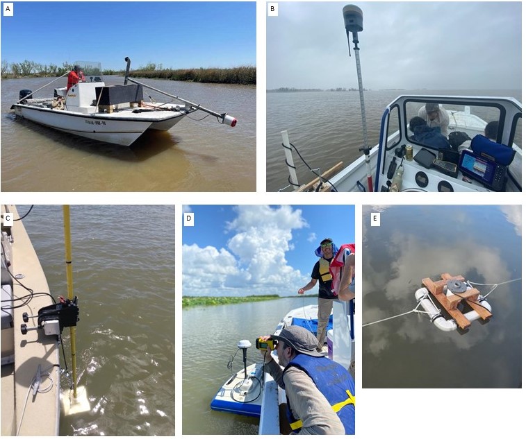
Figure 2. Researchers taking ADCP measurements along channel transects. (A) Louisiana State University Coastal Studies Institute using a front boat mount, (B) California Institute of Technology using a side boat mount, (C) the University of North Carolina using a side boat mount, (D) the Jet Propulsion Laboratory using a hydroboard mount, and (E) California Institute of Technology using a float mount.
Teams collected two or more replicates of each transect to ensure data quality, unless there was only time for collecting one transect, and returned to sites multiple times to collect data during different stages of the tidal cycle. All replicates are provided to allow users to perform additional quality assessment. The naming convention of transect files allows users to identify date, time, site, and replicate of each transect.
The CSI team collected one continuous back and forth transect, which was split and processed separately using WinRiver II software (Teledyne RD Instruments, 2018). Methods for transect data collection are described in chapter 10 of the WinRiver II User Guide (Teledyne RD Instrument, 2018). At the beginning of each day in the field, the tasks outlined in Chapter 3 of the WinRiver II User Guide (Teledyne, 2020) were completed using the WinRiver II software that controls ADCP data collection including compass calibration, system tests, and site setting adjustments. Similar tasks were completed according to Section 6 of the RiverSurveyor Live Manual (SonTek, 2018) using the RiverSurveyor Live software.
ADCP flow velocity measurements depend on salinity because salinity affects the speed of sound in water. All transects in the Atchafalaya Basin were assigned a salinity of 0 parts per thousand (ppt) because all Atchafalaya transects were collected in freshwater. For the Terrebonne Basin transects, the field teams measured salinity in situ with YSI conductivity meter or equivalent for some transects and used the salinity measurements to correct ADCP flow velocity measurements. For transects without in situ salinity measurements, salinity was estimated from the data at the nearest Louisiana Coastwide Reference Monitoring System (CRMS) site. The choice of salinity estimation method is expected to have little influence on ADCP measurements because ADCP discharges varied little (within 5%) in the plausible ranges of salinity.
During Spring 2021, the CSI team experienced communication issues between the ADCP and the external GPS unit (Vector VS1000), which produced significant errors in the timestamp of GPS data for some transects. Post-processing was required in all CSI transects to correct external GPS data when possible or to replace external GPS data with internal GPS data from the ADCP instrument. In many cases, GPS data are not available for an ensemble and are replaced with -9999 values. Fortunately, transects were completed at planned locations, and users are encouraged to use planned coordinates (‘planned_longitude’ and ‘planned_latitude’ variables in DeltaX_RiverDischarge_Spring2021.csv) as a reference to transect location. Due to issues with external GPS data, the bottom track was used as the reference track for all CSI transects, but moving bed measurements were not done due to errors in the software. In addition, due to these issues, velocity profiles are not included for the CSI data. The Caltech team used an external RTK GPS unit (Trimble R12), which was merged with the ADCP data during post-processing.
During Fall 2021, the JPL, UNC, and Caltech teams did not experience GPS issues and were able to use GPS for tracking. The Caltech team again used an external RTK GPS unit (Trimble R12), the data of which were merged with the ADCP data during post-processing. GPS locations were used for tracking, and thus, moving bed tests were not needed.
Data Access
These data are available through the Oak Ridge National Laboratory (ORNL) Distributed Active Archive Center (DAAC).
Delta-X: Acoustic Doppler Current Profiler Channel Surveys, MRD, Louisiana, 2021, V2
Contact for Data Center Access Information:
- E-mail: uso@daac.ornl.gov
- Telephone: +1 (865) 241-3952
References
Denbina, M., M. Simard, E. Rodriguez, X. Wu, A. Chen, and T. Pavelsky. 2019. Mapping water surface elevation and slope in the Mississippi River Delta Using the AirSWOT Ka-band interferometric synthetic aperture radar. Remote Sensing 11:2739. https://doi.org/10.3390/rs11232739
Denbina, M.W., M. Simard, E. Rodriguez, X. Wu, and C. Michailovsky. 2021. Pre-Delta-X: L3 AirSWOT-derived Water Level Profiles, Wax Lake Outlet, LA, USA, 2015. ORNL DAAC, Oak Ridge, Tennessee, USA. https://doi.org/10.3334/ORNLDAAC/1819
Mueller, D.S., C.R. Wagner, M.S. Rehmel, K.A. Oberg, and F. Rainville. 2013. Measuring discharge with acoustic Doppler current profilers from a moving boat. Techniques and Methods, book 3, chapter A22. U.S. Geological Survey. https://dx.doi.org/10.3133/tm3A22
Simard, M., M.W. Denbina, D.J. Jensen, and R. Lane. 2020. Pre-Delta-X: Water Levels across Wax Lake Outlet, Atchafalaya Basin, LA, USA, 2016. ORNL DAAC, Oak Ridge, Tennessee, USA. https://doi.org/10.3334/ORNLDAAC/1801
Simard, M., K. Liu, M.W. Denbina, D. Jensen, E. Rodriguez, T.H. Liao, A. Christensen, C.E. Jones, R. Twilley, M.P. Lamb, and N.A. Thomas. 2017. Modeling river discharge and sediment transport in the Wax Lake-Atchafalaya basin with remote sensing parametrization. AGU Fall Meeting, abstract: H52G-06. https://agu.confex.com/agu/fm17/meetingapp.cgi/Paper/236837
Simard, M., M.W. Denbina, D.J. Jensen, and R. Lane. 2020. Pre-Delta-X: Water Levels across Wax Lake Outlet, Atchafalaya Basin, LA, USA, 2016. ORNL DAAC, Oak Ridge, Tennessee, USA. https://doi.org/10.3334/ORNLDAAC/1801
SonTek. 2018. RiverSurveyor S5/M9 System Manual, Software Version 4.1, Firmware Version 4.02. https://www.tttenviro.com/wp-content/uploads/Manual-M9-Acoustic-Doppler-Profiler-ADP.pdf
Teledyne RD Instruments, Inc. 2020. WinRiver II Software User’s Guide. P/N 957-6231-00.
Dataset Revisions
| Version | Release Date | Revision Notes |
|---|---|---|
| 2 | 2022-09-23 | Fall 2021 data added. Spring 2021 data updated. |
| 1 | 2021-10-29 | Original release holding Spring 2021 data |