Documentation Revision Date: 2022-05-05
Dataset Version: 1.3.1.1
Summary
There are 19 data files,18 models per year per file for 19 years, in netCDF (*.nc) format included in this dataset.
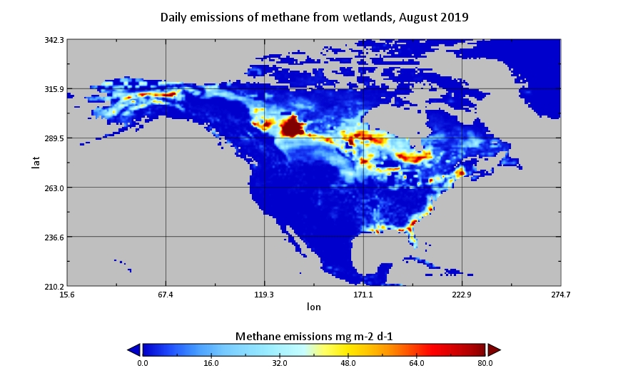
Figure 1. Estimated daily emissions of methane from wetlands in North American for August 2019. Estimates were produced using the WetCHARTs v1.3.1 model using ensemble member 1931, a global scale factor of 124.5 Tg CH4/yr, the CARDAMOM heterotrophic respiration model, a temperature-dependent CH4:C q10=3, and extent parameterization based on the Global Lakes and Wetlands Database. Source: WetCHARTs_v1_3_1_2019.nc
Citation
Bloom, A.A., K.W. Bowman, M. Lee, A.J. Turner, R. Schroeder, J.R. Worden, R.J. Weidner, K.C. McDonald, and D.J. Jacob. 2021. CMS: Global 0.5-deg Wetland Methane Emissions and Uncertainty (WetCHARTs v1.3.1). ORNL DAAC, Oak Ridge, Tennessee, USA. https://doi.org/10.3334/ORNLDAAC/1915
Table of Contents
- Dataset Overview
- Data Characteristics
- Application and Derivation
- Quality Assessment
- Data Acquisition, Materials, and Methods
- Data Access
- References
- Dataset Revisions
Dataset Overview
This dataset provides global monthly wetland methane (CH4) emissions estimates at 0.5 by 0.5-degree resolution for the period 2001-2019 that were derived from an ensemble of multiple terrestrial biosphere models, wetland extent scenarios, and CH4:C temperature dependencies that encompass the main sources of uncertainty in wetland CH4 emissions. There are 18 model configurations. WetCHARTs v1.3.1 is an updated product of WetCHARTs v1.0 Extended Ensemble. Three new features in the updated version include (1) the model output data is updated from 2001-2015 to 2001-2019, (2) the model drivers are replaced from using ERA-interim to ERA5 reanalysis data, and (3) the Global Lakes and Wetlands Database (GLWD) wetland extent definitions have been adjusted for the 50-100% Wetland, 25-50% Wetland, and Wetland Complex (0-25% Wetland) categories. The intended use of this product is as a process-informed wetland CH4 emission data set for atmospheric chemistry and transport modeling. Users can compare estimates by model configuration to explore variability and sensitivity with respect to ensemble members.
Project: Carbon Monitoring System
The NASA Carbon Monitoring System (CMS) is designed to make significant contributions in characterizing, quantifying, understanding, and predicting the evolution of global carbon sources and sinks through improved monitoring of carbon stocks and fluxes. The System will use the full range of NASA satellite observations and modeling/analysis capabilities to establish the accuracy, quantitative uncertainties, and utility of products for supporting national and international policy, regulatory, and management activities. CMS will maintain a global emphasis while providing finer scale regional information, utilizing space-based and surface-based data, and will rapidly initiate generation and distribution of products both for user evaluation and to inform near-term policy development and planning.
Related Publications
Bloom, A.A., K.W. Bowman, M. Lee, A.J. Turner, R. Schroeder, J.R. Worden, R. Weidner, K.C. McDonald, and D.J. Jacob. 2017. A global wetland methane emissions and uncertainty dataset for atmospheric chemical transport models (WetCHARTs version 1.0). Geoscientific Model Development 10:2141–2156. https://doi.org/10.5194/gmd-10-2141-2017
Ma, S., J.R Worden, A. Anthony Bloom, Y. Zhang, B. Poulter, D.H. Cusworth, Y. Yin, S. Pandey, J.D. Maasakkers, X. Lu, L. Shen, J. Sheng, C. Frankenberg, C.E. Miller, and D.J. Jacob, 2021. Satellite methane observations constrain the latitudinal distribution of wetland emissions and their temperature sensitivity. AGU Advances. https://doi.org/10.1029/2021AV000408
Related Dataset
Bloom, A.A., K. Bowman, M. Lee, A.J. Turner, R. Schroeder, J.R. Worden, R.J. Weidner, K.C. McDonald, and D.J. Jacob. 2017. CMS: Global 0.5-deg Wetland Methane Emissions and Uncertainty (WetCHARTs v1.0). ORNL DAAC, Oak Ridge, Tennessee, USA. https://doi.org/10.3334/ORNLDAAC/1502
Data Characteristics
Spatial Coverage: Global
Spatial Resolution: 0.5-degree resolution
Temporal Resolution: Monthly
Temporal Coverage: 2001-01-01 to 2019-12-31
Site Boundaries: Latitude and longitude are given in decimal degrees.
| Site | Westernmost Longitude | Easternmost Longitude | Northernmost Latitude | Southernmost Latitude |
|---|---|---|---|---|
| Global | -179.75 | 179.75 | 89.75 | -89.75 |
Data File Information
There are 19 data files,18 models per year per file for 19 years, in netCDF (*.nc) format included in this dataset. The files are named WetCHARTs_v1_3_1_YYYY.nc, where YYYY is a year from 2001–2019.
Data File Details
- Spatial reference system: WGS 84 (EPSG:4326)
- Unit: degree
- No data value: -9999
Table 1. Variables in the data files.
| Variable | Units | Description |
|---|---|---|
| wetland_CH4_emissions | mg m-2 d-1 | Daily emissions of methane from wetlands |
| latitude | degrees_north | Latitude coordinate |
| longitude | degrees_east | Longitude coordinate |
| model |
Four-digit code specifying the 18 model configuration (e.g., 1931; Table 3), where:
|
|
| time | days since 2001-01-01 00:00:00 | Middle of each month |
| crs | Details of the coordinate reference system | |
| time_bnds | days since 2001-01-01 00:00:00 | Start and end time for each time stamp |
Table 3. Model configuration codes. The ensemble model member names follow a 4-digit format (e.g., 1234).
| Position | Values | Description |
|---|---|---|
| 1 | global_scale_factors | 1 = 124.5 Tg CH4/yr 2 = 166 Tg CH4/yr 3 = 207.5 Tg CH4/yr |
| 2 | heterotrophic_respiration_model | 1–8 = MsTMIP models 9 = CARDAMOM |
| 3 | temperature_dependence | 1 = CH4:C q10 is 1 2 = CH4:C q10 is 2 3 = CH4:C q10 is 3 |
| 4 | extent_parameterization | 1 = SWAMPS & GLWD 2 = SWAMPS & GLOBCOVER 3 = PREC & GLWD 4 = PREC & GLOBCOVER |
Application and Derivation
Bloom et al. (2017) have constructed a global wetland CH4 emission model ensemble for use in atmospheric chemical transport models (WetCHARTs v1.0).
Ma et al. (2021) have tested and refined a range of bottom-up models including the WetCHARTs v1.3.1 with satellite-based top-down estimates, adding new constraints on the latitudinal distributions of CH4 and its temperature sensitivity.
Quality Assessment
The mean extended ensemble wetland emissions data were compared against a range of independent wetland CH4 regional emission estimates (Bloom et al., 2017).
Data Acquisition, Materials, and Methods
This process-informed wetland CH4 emission dataset for atmospheric chemistry and transport modeling (WetCHARTs Extended Ensemble, 18 simulations) is derived by combining a range of CH4:C temperature sensitivities, global wetland emissions scaling factors, and dynamic wetland extent maps to represent the uncertainty. The wetland CH4 emissions statistics within each 0.5° x 0.5° grid cell are derived based on precipitation and the data-constrained terrestrial carbon cycle analysis derived for the period 2001–2019. The mean of the extended model ensembles was incorporated into GEOS-Chem and the model outputs have been compared against a suite of regional flux estimates. The wetland CH4 emission ensembles robustly represent the global magnitude and uncertainty of wetland CH4 missions. The ensemble configurations of inundation extent, carbon decomposition, and temperature dependence have together provided a characterization of the dominant source of uncertainty in global wetland CH4 estimates and can then be used to quantify (a) the probability of individual ensemble members; and (b) the combined probability distribution of carbon models, CH4:C temperature dependencies and wetland extent scenarios.
WetCHARTs v1.3.1 is an updated product of WetCHARTs v1.0 Extended Ensemble. Three new features in the updated version include:
- The model output data have been updated to span 2001–2019,
- The model meteorological drivers are replaced from using ERA-interim to ERA5 reanalysis data, and
- The GLWD (Global Lakes and Wetlands Database) wetland extent definitions within WetCHARTs have been adjusted for the 50-100% Wetland, 25-50% Wetland, and Wetland Complex (0-25% Wetland) categories (that span 75%, 37.5% and 17.5% of land area respectively).
For details see Bloom et al. (2017).
Data Access
These data are available through the Oak Ridge National Laboratory (ORNL) Distributed Active Archive Center (DAAC).
CMS: Global 0.5-deg Wetland Methane Emissions and Uncertainty (WetCHARTs v1.3.1)
Contact for Data Center Access Information:
- E-mail: uso@daac.ornl.gov
- Telephone: +1 (865) 241-3952
References
Bloom, A.A., K.W. Bowman, M. Lee, A.J. Turner, R. Schroeder, J.R. Worden, R. Weidner, K.C. McDonald, and D.J. Jacob. 2017. A global wetland methane emissions and uncertainty dataset for atmospheric chemical transport models (WetCHARTs version 1.0). Geoscientific Model Development 10:2141–2156. https://doi.org/10.5194/gmd-10-2141-2017
Bontemps, S., P. Defourny, E. Van Bogaert, O. Arino, V. Kalogirou and J.R. Perez.2011. GLOBCOVER 2009 Products description and validation report. Université catholique de Louvain & European Space Agency. https://doi.pangaea.de/10013/epic.39884.d016
Lehner, B., and P. Döll. 2004. Development and validation of a global database of lakes, reservoirs and wetlands. Journal of Hydrology 296:1–22. https://doi.org/10.1016/j.jhydrol.2004.03.028
Ma, S., J.R Worden, A. Anthony Bloom, Y. Zhang, B. Poulter, D.H. Cusworth, Y. Yin, S. Pandey, J.D. Maasakkers, X. Lu, L. Shen, J. Sheng, C. Frankenberg, C.E. Miller, and D.J. Jacob, 2021, Satellite methane observations constrain latitudinal distribution of wetland emissions and their climate sensitivity. Accepted by AGU Advances.
Dataset Revisions
| Version | Release Date | Revision Notes | DOI |
|---|---|---|---|
| 1.3.1.1 | 2022-05-05 |
Latitude, longitude variable names changed in the data files to improve compatibility with GIS software |
https://doi.org/10.3334/ORNLDAAC/1915 |
| 1.3.1 | 2021-09-23 | WetCHARTs v1.3.1 is an updated product of WetCHARTs v1.0 Extended Ensemble (Bloom et al., 2017). The new features are described in Section 5. | https://doi.org/10.3334/ORNLDAAC/1915 |
| 1 | 2017-06-05 | Initial release. | https://doi.org/10.3334/ORNLDAAC/1502 |