Documentation Revision Date: 2017-07-14
Data Set Version: 1
Summary
This data set includes 7603 files in netCDF (*.nc4) format. The algorithm theoretical basis document (ATBD) for this data product is included as a companion file.

Figure 1: Modeled surface (0 - 10 cm) soil moisture at the Metolius site, Oregon, at midnight on Feb. 25, 2014.
Citation
Crow, W.T., S. Milak, and R.H. Reichle. 2017. AirMOSS: L4 Modeled Volumetric Root Zone Soil Moisture, 2012-2015. ORNL DAAC, Oak Ridge, Tennessee, USA. https://doi.org/10.3334/ORNLDAAC/1421
Table of Contents
- Data Set Overview
- Data Characteristics
- Application and Derivation
- Quality Assessment
- Data Acquisition, Materials, and Methods
- Data Access
- References
Data Set Overview
This data set provides hourly gridded soil moisture estimates derived from hydrologic modeling at nine AirMOSS sites across North America. The AirMOSS L4 RZSM product represents a temporal interpolation of intermittent AirMOSS L2/3 RZSM retrievals into a temporally-continuous, multi-layer, hourly soil moisture product. The L4 RZSM data have the same spatial resolution (3-arcsecs or ~100 m), and the same temporal coverage (generally Fall 2012 through Fall 2015), as the underlying L2/3 RZSM data. The L4 RZSM data were produced by the integration of the Level 2/3 product and other ancillary information into the Penn State Integrated Hydrologic Model (PIHM). Many key applications for AirMOSS data products, including the calculation of net ecosystem exchange (NEE), require temporally continuous RZSM estimates such as those provided here.
Project: Airborne Microwave Observatory of Subcanopy and Subsurface (AirMOSS)
The goal of NASA’s Airborne Microwave Observatory of Subcanopy and Subsurface (AirMOSS) investigation is to provide high-resolution observations of root-zone soil moisture over regions representative of the major North American climatic habitats (biomes), quantify the impact of variations in soil moisture on the estimation of regional carbon fluxes, and extrapolate the reduced-uncertainty estimates of regional carbon fluxes to the continental scale of North America.
- The AirMOSS campaign used an airborne ultra-high frequency synthetic aperture radar flown on a Gulfstream-III aircraft to derive estimates of soil moisture down to approximately 1.2 meters.
- Extensive ground, tower, and aircraft in-situ measurements were collected to validate root-zone soil measurements and carbon flux model estimates.
The AirMOSS soil measurements can be used to better understand carbon fluxes and their associated uncertainties on a continental scale. Additionally, AirMOSS data provide a direct means for validating root-zone soil measurement algorithms from the Soil Moisture Active & Passive (SMAP) mission and assessing the impact of fine-scale heterogeneities in its coarse-resolution products.
Related Data:
The following AirMOSS data were directly used to generate this data:
Moghaddam, M., A. Tabatabaeenejad, R.H. Chen, S.S. Saatchi, S. Jaruwatanadilok, M. Burgin, X. Duan, and M.L. Truong-Loi. 2016. AirMOSS: L2/3 Volumetric Soil Moisture Profiles Derived From Radar, 2012-2015. ORNL DAAC, Oak Ridge, Tennessee, USA. http://dx.doi.org/10.3334/ORNLDAAC/1418
A full list of AirMOSS data products is available at: https://airmoss.ornl.gov/dataproducts.html.
Data Characteristics
Spatial Coverage: Nine AirMOSS sites across North America
Spatial Resolution: 100 meters
Temporal Coverage: 20120921 to 20150928. Coverage at individual sites is provided in Table 1.
Temporal Resolution: Hourly
Study Area (coordinates in decimal degrees)
|
Site |
Westernmost Longitude |
Easternmost Longitude |
Northernmost Latitude |
Southernmost Latitude |
|
North America |
-123.28 |
-68.124 |
54.125 |
19.125 |
Table 1. AirMOSS sites. Note that L4 RZSM data were not produced for the La Selva, Costa Rica site.
|
Site name |
North latitude |
South latitude |
East longitude |
West longitude |
L4 RZSM date range |
Fluxnet Site ID |
Description |
|
BermsP |
54.125 |
53.501 |
-103.626 |
-107.125 |
20121025 to 20150927 |
CA-Ojp & CA-Oas |
BERMS (Boreal Ecosystem Research and Monitoring Sites), Saskatchewan, Canada. Landcover: Mixed boreal forest. Elevation: 518m. |
|
Chamel |
20.326 |
19.316 |
-104.22 |
-105.29 |
20130616 to 20150414 |
MX-Cha |
Chamela Biological Station, Jalisco, Mexico. Landcover: Seasonally dry tropical forest. Elevation: 58m. |
|
DukeFr |
36.368 |
35.437 |
-78.694 |
-79.849 |
20121014 to 20130823 |
US-Dk1,US-Dk2, US-Dk3 |
Duke Forest site, North Carolina, USA. Landcover: Mature oak-hickory dominated hardwood forest. Elevation: 169m. |
|
Harvrd |
43.376 |
42.293 |
-71.839 |
-72.389 |
20121016 to 20150908 |
US-Ha1 & US-Ha2 |
Harvard Forest site, Massachusetts, USA. Landcover: Temperate deciduous forest. Elevation: 353m. |
|
Howlnd |
45.778 |
44.669 |
-68.336 |
-69.086 |
20121016 to 20150908 |
US-Ho1, US-Ho2, US-Ho3 |
Howland Forest site, Maine, USA. Landcover: boreal - northern hardwood transitional forest. Elevation 72m. |
|
LaSelv |
10.878 |
9.92 |
-83.519 |
-84.57 |
none |
CR-Lse |
La Selva Biological Station, Costa Rica. Landcover: tropical rain forest. Elevation 93m. |
|
Metoli |
45.242 |
43.38 |
-120.363 |
-123.283 |
20121014 to 20150928 |
US-Me1 to US-Me6 |
Metolius site, Oregon, USA. Landcover: evergreen needleleaf forest. Elevation 1237m. |
|
Moisst |
36.880 |
35.775 |
-96.824 |
-98.996 |
20121025 to 20150812 |
US-ARM |
The Marena, Oklahoma In Situ Sensor Testbed (MOISST) is located in Oklahoma, USA. Landcover: temperate grasslands, crops. Elevation: 312m. |
|
TonziR |
38.625 |
37.501 |
-120.001 |
-121.25 |
20131025 to 20150530 |
US-Ton |
Tonzi Ranch site, California, USA. Landcover: oak savanna and grazed grassland. Elevation 170m. |
|
Walnut |
32.125 |
31.501 |
-109.376 |
-111.5 |
20120921 to 20150831 |
US-Wkg & US-Whs |
Walnut Gulch site, Arizona, USA. Landcover: warm season C4 grassland with a few shrubs. Elevation 1524m. |
Data File Information
This data set includes 7603 files in netCDF (*.nc4) format. Each file represents one day at one site and contains 24 data layers, one for each hour of the day. The algorithm theoretical basis document (ATBD) for this data product is included as a companion file (L4RZSM_ATBD_V10.pdf).
Geographic projection & coordinate system: WGS84
File naming convention
AirMOSS L4 RZSM data file names have the format: L4RZSM_ssssss_yyyymmdd_vv.nc4
where: ssssss = site name; yyyymmdd = date; vv = version number. All sites except DukeFr are version 5.
Table 2. Data fields in the L4 RZSM data files. Missing data are represented by -9999.
|
Data Field |
Units |
Description |
|
browse |
vol / vol |
Browse layer. Gridded soil moisture for the surface layer (sm1) at the last hour of the day. |
|
lat |
degrees North |
Latitude of grid cell |
|
lon |
degrees East |
Longitude of grid cell |
|
sm1 |
vol / vol |
Gridded hourly soil moisture at depth 0-10 cm. |
|
sm2 |
vol / vol |
Gridded hourly soil moisture at depth 10-40 cm. |
|
sm3 |
vol / vol |
Gridded hourly soil moisture at depth 40 – 100 cm. |
|
sm4 |
vol /vol |
Gridded hourly soil moisture at depth 100 - 200 cm. Not all sites and dates have sm4 data. |
|
time |
Hours since 2010-01-01 00:00:00 UTC |
Date and hour of modeled output. Each file contains only one day (24 hours) of data. |
Incomplete Data Notes:
Data files are not available for the following sites and dates:
Moisst: 20140109, 20140124, 20140204, 20140210, 20140214, 20140225, 20140302, 20140301, 20140315, 20140320, 20140324, 20140403, 20140404, 20140405, 20140407, 20140420, 20140421, 20140503, 20140504, 20140522, 20140612, 20140622, 20140801, 20140812, 20140813, 20140827, 20140829, 20140926, 20140927, 20141012, 20141023, 20141028, 20141106, 20141112, 20141115, 20141118, 20141127, 20141210, 20141230, 20141231
Harvrd: 20130101-20130823, 20130830, 20130831, 20140824
TonziR: 20140710, 20140712, 20140824
Data files for the following sites and dates contain only 'no-data' values:
Howland: 20121231-20130831
TonziR: 20140916-20141021, 20141127-20150102, 20150209-20150316, 20150424-20150528
Application and Derivation
The AirMOSS data products and expected science results are tailored to meet the need to reduce uncertainty in estimates of net ecosystem exchange (NEE) through the development of methodologies to integrate remote sensing observations, in-ground soil sensors, and flux tower data into regional/continental flux models. Additionally, AirMOSS data provide a direct means for evaluating RZSM algorithms of the SMAP Decadal Survey mission and assessing the impact of fine-scale heterogeneities in its coarse-resolution products.
Quality Assessment
The hydrologic model at the core of the L4 RZSM algorithm requires a diverse set of soil, geologic and vegetation parameters to accurately capture the flux and storage of water within (and out of) a hydrologic catchment. Failure to accurately specify these parameters can degrade the accuracy of model predictions. While all efforts will be made to minimize calibration error by considering all available stream flow and soil hydraulic property information, model calibration errors will likely persist and impact the accuracy of L4 RZSM estimates.
Product error estimates are derived via the comparison of L4 RZSM algorithm output with independent, ground-based soil moisture observations acquired within individual AirMOSS study sites. Error estimates are shown in the ATBD document for this data product.
Data Acquisition, Materials, and Methods
The goal of the Airborne Microwave Observatory of Subcanopy and Subsurface (AirMOSS) investigation is to provide high-resolution observations of root-zone soil moisture over regions representative of the major North American climatic habitats (biomes), quantify the impact of variations in soil moisture on the estimation of regional carbon fluxes, and extrapolate the reduced-uncertainty estimates of regional carbon fluxes to the continental scale of North America.
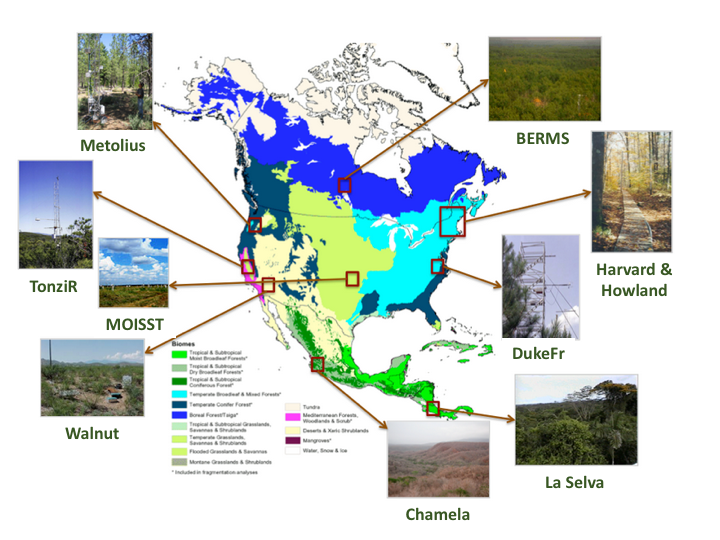
Figure 2. AirMOSS study sites were co-located with flux towers in nine different biomes across North America.
AirMOSS Flights
For AirMOSS, NASA's Uninhabited Aerial Vehicle Synthetic Aperture Radar (UAVSAR) was flown on a Gulfstream-III aircraft, making frequent flights over ten sites (Table 1 and Figure 2) in 9 different biomes of North America over the course of four years (Chapin et al. 2012).
Beginning in September 2012, the AirMOSS instrument flew 215 flight campaigns. A summary of flight campaigns by year and site is found in Table 3. Typically, the aircraft made repeat visits to sites in the same region in a single week and then proceeded to another region. Most sites had at least three campaigns per year. The Harvard and Howland forest sites were flown together in a single day. In 2012, Chamela, La Selva, and Tonzi were not surveyed.
Table 3. Summary of AirMOSS flight campaigns.
|
Site |
||||||||||
|
Year |
BermsP |
Chamel |
DukeFr |
Harvrd |
Howlnd |
LaSelv |
Metoli |
Oklaho |
TonziR |
Walnut |
|
2012 |
3 |
0 |
3 |
3 |
3 |
0 |
4 |
3 |
0 |
3 |
|
2013 |
6 |
3 |
9 |
9 |
9 |
6 |
7 |
8 |
5 |
6 |
|
2014 |
7 |
3 |
10 |
9 |
9 |
3 |
9 |
9 |
6 |
5 |
|
2015 |
9 |
2 |
5 |
5 |
5 |
3 |
9 |
6 |
5 |
6 |
|
Total |
25 |
8 |
27 |
26 |
26 |
12 |
29 |
26 |
16 |
20 |
A complete list of AirMOSS flights can be found at: https://airmoss.ornl.gov/flights.html.
AirMOSS Level 4 Root Zone Soil Moisture Data Product
The objective of the AirMOSS L4 RZSM algorithm is the realistic temporal interpolation of intermittent AirMOSS L2/3 RZSM retrievals into a temporally-continuous, multi-layer, hourly soil moisture product. For information about L2/3 RZSM, see Moghaddam et al. (2016; http://dx.doi.org/10.3334/ORNLDAAC/1418). The L4 RZSM algorithm is based on the Penn State Integrated Hydrologic Model (PIHM; Figure 3) that makes continuous predictions about the evolution of soil moisture states in response meteorological drivers such as rainfall and incident radiation [Qu and Duffy, 2007; Yu et al., 2014].
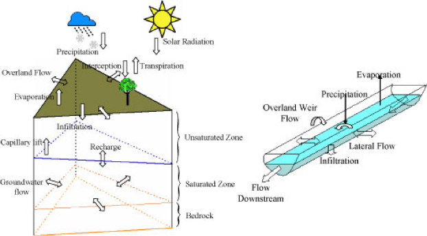
Figure 3. Schematic of physical processes represented in the Penn State Integrated Hydrologic Model (PIHM).
As illustrated in Figure 4 below, the L4 RZSM algorithm consists of three components:
(1) a hydrologic model, PIHM,
(2) a bilinear integration procedure, where AirMOSS L2/3 RZSM data is integrated with the PIHM output,
(3) and pre- and post-processing stages required to transform RZSM products between specified AirMOSS project formats and the format requirements of the hydrologic model.
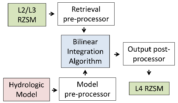
Figure 4. Schematic of the AirMOSS L4 RZSM processing system.
The integration of AirMOSS L2/3 RZSM retrievals in the PIHM model was based on a relatively simple bilinear-interpolation integration approach. Figure 5 provides a graphical example for a single PIHM soil layer. More details of algorithm implementation are given in the ATBD for this product.
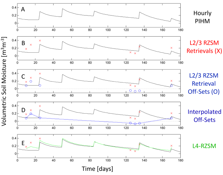
Figure 5. Example of the bilinear integration of AirMOSS L2/3 data with PIHM to produce L4 RZSM.
Data Access
These data are available through the Oak Ridge National Laboratory (ORNL) Distributed Active Archive Center (DAAC).
AirMOSS: L4 Modeled Volumetric Root Zone Soil Moisture, 2012-2015
Contact for Data Center Access Information:
- E-mail: uso@daac.ornl.gov
- Telephone: +1 (865) 241-3952
References
Chapin, E., A. Chau, J. Chen, B. Heavey, S. Hensley, Y. Lou, R. Machuzak, and M. Moghaddam. 2012. AirMOSS: An Airborne P-band SAR to measure root-zone soil moisture, 2012 IEEE Radar Conference, Atlanta, GA, 2012, pp. 0693-0698. http://dx.doi.org/10.1109/RADAR.2012.6212227
Moghaddam, M., A. Tabatabaeenejad, R.H. Chen, S.S. Saatchi, S. Jaruwatanadilok, M. Burgin, X. Duan, and M.L. Truong-Loi. 2016. AirMOSS: L2/3 Volumetric Soil Moisture Profiles Derived From Radar, 2012-2015. ORNL DAAC, Oak Ridge, Tennessee, USA. http://dx.doi.org/10.3334/ORNLDAAC/1418
Qu, Y., and Duffy, C.J. (2007) A semidiscrete finite volume formulation for multiprocess watershed simulation. Water Resources Research, 43(8), W08419. http://dx.doi.org/10.1029/2006WR005752
Yu, X., Duffy, C., Kaye, J., Crow, W., Bhatt, G. and Shi, Y. (2014) Watershed Reanalysis of Water and Carbon Cycle Models at a Critical Zone Observatory, in Remote Sensing of the Terrestrial Water Cycle (eds. V. Lakshmi, D. Alsdorf, M. Anderson, S. Biancamaria, M. Cosh, J. Entin, G. Huffman, W. Kustas, P. van Oevelen, T. Painter, J. Parajka, M. Rodell and C. Rüdiger), John Wiley & Sons, Inc, Hoboken, NJ. http://dx.doi.org/10.1002/9781118872086.ch31