Get Data
Summary
Area (Phase 2) and regional (Phase 3) gridded data sets have been generated by an objective analysis scheme using all of the surface meteorological station data over BOREAS region for 1994-1996. Additionally, FSU GOES incoming solar radiation retrievals and BOREAS rain radar retrievals during portions of 1994 and 1996 were used when remote sensing products were available. Two Phase 2, Northern Study Area (NSA) and Southern Study Area (SSA) grids, and one Phase 3, Regional, gridded data sets have been assembled on a hourly time step.The meteorological variables in this data set are surface air pressure, air temperature, dew point temperature, wind speed, wind direction, precipitation, incoming solar (shortwave) radiation, and incoming infrared (longwave) radiation.
Note that some of the data files have been compressed using Zip compression. See Section 8.2 for details.
Data Citation
Cite this data set as follows (citation revised on October 30, 2002):Wood, E., and V. Pauwels. 2001. BOREAS Follow-On HMet-02 Area and Regional Hourly Gridded Met[eorological] Data, 1994-1996. Available on-line [http://www.daac.ornl.gov] from Oak Ridge National Laboratory Distributed Active Archive Center, Oak Ridge, Tennessee, U.S.A.
Table of Contents
- Data Set Overview
- Investigator(s)
- Theory of Measurements
- Equipment
- Data Acquisition Methods
- Observations
- Data Description
- Data Organization
- Data Manipulations
- Errors
- Notes
- Application of the Data Set
- Future Modifications and Plans
- Software
- Data Access
- Output Products and Availability
- References
- Glossary of Terms
- List of Acronyms
- Document Information
1. Data Set Overview
BOREAS Follow-On HMet-02 Area and Regional Hourly Gridded Met. Data, 1994-1996
1.2 Data Set Introduction
BOREAS Hydromet/Carbon Model Subgroups
meteorological forcing data sets for Phases I, II, & III modeling intercomparisons.
1.3 Objective/Purpose
Surface station data and remote sensing
data over the BOREAS region were gridded in order to provide the investigators
of the BOREAS Follow-On Water/Energy modeling subgroup with a standard
model forcing data set for intercomparison studies. Six (6) different hydrometeorological
models & nine (9) different carbon models were selected for intercomparison
purposes.
1.4 Summary of Parameters
Meteorological forcing data consist
of following eight (8) parameters: 1) Air temperature 2) Dew point temperature
3) Wind speed 4) Wind direction 5) Air pressure 6) Incoming solar radiation
7) Incoming long wave radiation 8) Precipitation
1.5 Discussion
This data set includes Phases 2 and
3 of the three categories of meteorological forcing data sets that have
been assembled for the BOREAS Hydrometeorological and Carbon Assimilation
Model Intercomparison Projects as part of the BOREAS Follow-on activities.
The first phase of the meteorological forcing data sets, Phase I data,
at point/tower scale, has also been produced.
1.6 Related Data Sets
BOREAS AES MARSII Surface Meteorological Data
BOREAS AES READAC Surface Meteorological Data
BOREAS AFM-07 SRC Surface Meteorological and Radiation Data
BOREAS TF-1 SSA-OA Tower Flux, Meteorological, and Soil Temperature
Data
BOREAS TF-2 SSA-OA Tower Flux, Meteorological, and Precipitation Data
BOREAS TF-3 NSA-OBS Tower Flux, Meteorological, and Soil Temperature
Data
BOREAS TF-4 SSA-YJP Tower Flux, Meteorological, and Canopy Condition
Data
BOREAS TF-6 SSA-YA Surface Energy Flux and Meteorological Data
BOREAS TF-8 NSA-OJP Tower Flux, Meteorological, and Soil Temperature
Data
BOREAS TF-9 SSA-OBS Tower Flux, Meteorological, and Soil Temperature
Data
BOREAS TF-10 NSA-Fen Tower Flux and Meteorological Data
BOREAS TF-10 NSA-YJP Tower Flux, Meteorological, and Porometry Data
BOREAS TF-11 SSA-Fen Tower Flux and Meteorological Data
BOREAS TGB-4 NSA-BVP Tower Flux and Meteorological Data
BOREAS RSS-14 Level-2 GOES-7 Shortwave and Longwave Radiation Images
BOREAS Follow-on HMet-02 Area and Regional Hourly Gridded Met. Data,
1994-1996
2. Investigator(s)
Professor Eric Wood
2.2 Title of Investigation
A terrestrial water and energy budget
for the BOREAS study region scale using field measurements, remote sensing,
and modeling.
2.3 Contact Information
Contact 1:
Valentijn Pauwels
Ghent University
Ghent, Belgium
Tel. + 32 - 9 - 264 61 37
Fax + 32 - 9 - 264 62 36
email: vpauwels@taoren.rug.ac.be
Contact 2:
Prof. Eric Wood
Princeton University
Princeton, NJ
Tel. (609) 258-4675
Fax. (609) 258-2799
email : efwood@Princeton.edu
3. Theory of Measurements
(2) Special Issue on Remote Sensing in BOREAS in 1997 Canadian Journal of Remote Sensing (vol 23/no 2).
(3) 2nd BOREAS Special Issue in 1999 Journal of Geophysical Research (vol 104/issue D22).
4. Equipment
5. Data Acquisition Methods
AES Continuous Recording Stations: 15 min
These stations are long-term meteorological
sites which record continuous observations at 15 minute interval. Standard
suite of meteorological variables is measured including pressure, temperature,
humidity, wind speed, and wind direction. SW and LW radiation fluxes are
not measured. Fourteen (14) Automatic Meteorological Station (AMS)-type
systems collected data from August '93 through December '96. Six (6) Meteorological
Automatic Reporting System II (MARS-II) stations and one Remote Environmental
Automatic Acquisition Concept (READAC) station collected data during 1994
IFCs only. All of these stations collected standard meteorological data
and no radiation data.
SRC Meteorological Stations Suite A & B
These stations were installed and operated
by SRC specially for BOREAS project and recorded observations at a 15 minute
interval. This data set provides most complete coverage (temporally and
spatially) of meteorological conditions in Southern and Northern Study
Areas during period 1994-1996. Unlike most flux towers, these stations
also operated during winter months. Stations recorded full suite of meteorological
measurements, although only subset (Suite B) measured LW radiation fluxes.
Flux Tower Sites: 15 min
Largest suites of variables were measured
at BOREAS flux tower sites. Most towers measured all standard meteorological
variables at different levels. All levels are retained in quality controlled
BORIS data sets. Few towers operated during entire period from 1994-1996.
HYD-09 Belfort and Tipping Bucket Rain Gauges
HYD-09 Science Team operated dense precipitation
gauge network in Northern and Southern Study Areas during much of BOREAS
field period, although most observations were obtained during summer months
of 1994 and 1996.
Canadian Forest Service Meteorological Stations
These stations recorded hourly observations
during summers of 1994 and 1995 obtaining temperature, humidity, wind speed,
wind direction, and precipitation.
Canadian Historical Stations: Daily
These stations, also operated by AES
Canada, only record daily minimum, maximum, and mean temperature and precipitation.
Canadian Historical Stations: Hourly
These stations, also operated by AES
Canada, record observations on an hourly basis, involving larger suite
of variables than measured by daily stations, including pressure, temperature,
humidity, wind speed, wind direction, and cloudiness. SW and LW radiation
fluxes are not measured.
During winter months, when precipitation
estimates by each of the previously listed stations were missing, daily
precipitation data were resampled into hourly estimates using the average
diurnal cycle of precipitation, and then during December, January, and
February, these precipitation data were gridded.
Remote sensing data from following sources were also used in the gridding:
GOES satellite retrievals (Gu & Smith SRB algorithm):
Retrievals of incoming solar radiation
over The BOREAS region, from days 36-263 (Feb 5-Sep 20)-1994 and days 43-296
(Feb 12-Oct 22)-1996, were blended into gridded data sets -- treating each
GOES pixel as a separate station.
Enterprise WSR-100 radar:
Retrievals of precipitation over Southern
Study Area, from days 132-266 (May 12-September 23)-1994, were blended
into gridded data sets -- treating each radar pixel as a separate station.
In order to eliminate drizzle originating
from the interpolation of rainfall over large distances, all precipitation
values of intensity lower than 0.25 mm hr-1 have been set to zero.
6. Observations
7. Data Description
The data sets were prepared at two different scales and projections. For the study areas, the phase II data, a 2 kilometer UTM grid was used. For the regional data set, the phase III data, a 5 minutes (vertical) by 10 minutes (horizontal) grid was used.
7.1.1 Spatial Coverage
The grid chosen by the Water/Energy modeling subgroup was used for this data set.For Phase II NSA data set, grid corner locations are (UTM zone 14)
Corner         Northing (UTM)            Easting (UTM)
------------------------------------------------------
NW               6202000                    514000
NE               6202000                    548000
SW               6170000                    514000
SE               6170000                    548000
For Phase II SSA data set, grid corner locations are (UTM zone 13)Corner Northing (UTM) Easting (UTM) ------------------------------------------------------ NW 6000000 488000 NE 6000000 528000 SW 5964000 488000 SE 5964000 528000
For Phase III regional data set, grid corner locations are:Corner Latitude (degrees) Longitude (degrees) ----------------------------------------------------------- NW 57°N 107°W NE 57°N 96°W SW 52°N 107°W SE 52°N 96°W7.1.2 Spatial Coverage Map
A map of the geographic locations of the surface station sites, together with boundaries of the BOREAS region, study areas, original modeling region, and the Saskatchewan and Grass-Burntwood watershed basins (used for routing model validation) can be found in the GIF file 'locate.gif' (see below). Boundaries of GOES and Rain Radar coverage maps are not included.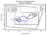
7.1.3 Spatial Resolution
The resolution is 2 x 2 km for Phase II study area data sets, and 10' horizontal (longitude) by 5' vertical (latitude) for Phase III regional data set.7.1.4 Projection
Projection is UTM for the Phase II study area data sets, and Geographic (latitude-longitude) for the Phase III regional data set.7.1.5 Grid Description
The NSA grid is 17 columns (longitude) by 16 rows (latitude). The SSA grid is 20 columns (longitude) by 18 rows (latitude). The regional grid is 66 columns (longitude) by 60 rows (latitude). The images are all binary with each pixel being stored as a four-byte binary float.
7.2 Temporal Characteristics
7.2.1 Temporal Coverage
Data gridded were from January 1, 1994 through December 31, 1996.7.2.2 Temporal Coverage Map
Not applicable.7.2.3 Temporal Resolution
Data were gridded at an hourly interval. Temporal units are in GMT.
7.3 Data Characteristics
7.3.1 Parameter/Variable7.4 Sample Data RecordVariable Image prefix --------------------------- ------------ Air pressure Pres Air temperature Ta Dew point temperature Td Wind speed U Wind direction Ud Precipitation Prec Incoming SW radiation Rsi Incoming LW radiation Lwi7.3.2 Variable Description/Definition
See section 7.3.1. Times are in GMT using backward time tag convention (i.e., time tag n indicates data record applies to hourly period n to n+1).
7.3.3 Unit of Measurement
Variable                   Measurement Units
-------------------------  -----------------
Air temperature                 C
Dew point temperature           C
Wind direction                  Degrees
Wind speed                      m/s
Air pressure                    kPa
Incoming SW radiation           Rsi
Incoming LW radiation           Lwi
Precipitation                   mm/h
7.3.4 Data Source
For data sources we refer to documentation files of individual input data sets.
7.3.5 Data Range
Variable    Minimum         Maximum     Missing value
             Value           value        indicator
--------   ---------      ----------    -------------
Ta        -46.013359       37.548920       -9999
Td        -53.659573       47.275021       -9999
Ud          0.000008      360.000000       -9999
U           0.000019       42.264545       -9999
Pres       86.865944      101.601524       -9999
Rsi        -4.899975     1042.467407       -9999
Lwi        55.841991      447.747894       -9999
Prec        0.000000      176.934235       -9999
Not applicable.
8. Data Organization
8.1 Data Granularity
Data exist for every hour when available.
The hour files have been organized into daily folders/directories. Each
filename has the following structure:
yy-mm-dd_hh_sss_V2.bin
where yy is the two-digit year, mm is the 2-digit month, dd is the 2-digit
day, hh is the hour of day (in GMT), sss is the site (nsa or ssa), and
V2 is the variable (such as "pres", with a 2 or 3 following it for Phase
2 or Phase 3 data).
Each of the eight variables has the
same directory structure. Each variable has three yearly subdirectories
(94, 95, and 96). Each yearly subdirectory contains 12 monthly Zip archive
files. Each of the Zip archive files contains daily subdirectories, which
each contain the 24 hourly data files.
For example, Northern Study Area Pressure
on 1 November 1995 at 14:00 UTC would be found in the following Zip file:
gridded_mesonet_p2/nsa/pres2_95_nsa/95-11-00_nsa_pres2.zip
Once decompressed, this Zip file would yield a directory for November 1995, and the specific file would be:
95-11-00_nsa_pres2/95-11-01_nsa_pres2/95-11-01_14_nsa_pres2.bin
8.2 Data Format(s)
The data are stored as 4-byte binary
float images, one image per hour per variable (the data may need to be byte
swapped to display properly). The regional grid is 66
columns by 60 rows. The NSA grid is 17 columns by 16 rows and the SSA grid
is 20 columns by 18 rows.
For this archive, the image files have
been compressed with the MS Windows-standard Zip compression scheme. These
files were compressed using Aladdin's DropZip on a Macintosh. DropZip uses
the Lempel-Ziv algorithm (Welch, 1994), also used in Zip and PKZIP programs.
The compressed files may be uncompressed using PKZIP (with the -expand
option) on MS Windows and UNIX, or with StuffIt Expander on the Mac OS.
You can get newer versions from the PKZIP Web site at http://www.pkware.com/download-software/
[Internet Link].
9. Data Manipulations
The data were interpolated using the weighted distance average of each pixel relative to each station. First, for each station the distance to the center of each pixel was determined, then the square of the inverse distances were summed. The ratio of the square of the inverse distance to a given pixel to this sum was used to weight each pixel.
This procedure did not produce satisfactory results for precipitation. In order to eliminate the large number of very low-intensity precipitation events caused by the interpolation of observed precipitation over large distances, a threshold method was applied for each grid. All time steps with a precipitation rate lower than the specified threshold were set to zero and their precipitation amounts were added to the nearest event with a precipitation rate larger than the threshold. This method was found to yield the best results using a threshold precipitation rate of 0.075 mm/h.
As a next step, the total number of rain-hours for each grid was calculated. For all grids there were approximately 5000 total rain-hours over the three years (as opposed to the approximately 1500 rain-hours observed by the gauges). To solve this discrepancy, the length of all individual storms was scaled by multiplying the length of the storm by the ratio of the number of observed to interpolated rain-hours. The new storm duration was centered around the mid-point of the original storm. For example, if an original storm lasted from 10 through 19 GMT (10 hours), and the length of the contracted storm was 5 hours, then the contracted storm would occur from 12 through 17 GMT. The total storm volume was conserved by first calculating the total volume of precipitation for both the original and contracted storms, and then by multiplying the precipitation rate of each time step of the contracted storm by the ratio of the original and contracted storm volumes. Using this method, the diurnal cycle of precipitation and the total rainfall amounts, together with the storm duration and the distribution of rainfall rates (as observed by the various rain gauges) were conserved.
9.1.1 Derivation Techniques and Algorithms
Not applicable.
9.2 Data Processing Sequence
9.2.1 Processing Steps
First the station data were converted to a common format, temporal resolution, and into common units. Using this derived data set the interpolation was done.9.2.2 Processing Changes
Not applicable.
9.3 Calculations
9.3.1 Special Corrections/Adjustments
All station observed values that were outside reasonable limits were found to correspond to be measurement errors. For all variables these values are:Variable Minimum Maximum Allowed Allowed -------- ------- ------- U 0 120 Ud 0 360 Ta -60 60 Td -60 60 Rsi -5 1200 Lwi 50 600 Pres 85 110 Prec 0 200Wind directions were afterward corrected in range 0-360 degrees.9.3.2 Calculated Variables
Air temperature, dew point temperature, wind speed, wind direction, air pressure, incoming long wave radiation, incoming short wave radiation and precipitation.
9.4 Graphs and Plots
Not applicable.
10. Errors
Errors in the data for each pixel can originate for the following reasons:
- Measurement errors (systematic and random sensor errors).
- For Phase I, II, and III data sets, for December, January and February of each year, on a few occasions, the diurnal cycle was imposed on daily measured hourly precipitation. Therefore, attention should be given to daily totals rather than hourly totals. Since in winter, precipitation amount is more important than exact time precipitation falls, this source of error is assumed to be acceptable for modeling purposes.
- Winter precipitation is probably on low side. Not only are measurements during this period limited, but measurement of snowfall is generally more problematic than measurement of rainfall.
- No LW observations were available for first 20 days of January-1994 (hour 0 on Jan 1 to hour 20 on Jan 20). For Phase II & III data sets, missing LW values have been synthesized from surface Ta-Td dependent expression due to Idso (1981: WSR, 17, 295-304) which assumes clear sky conditions.
10.2 Data Quality Assessment
10.2.1 Data Validation by Source
For this purpose we refer to the documentation files of the individual data sources. See section 3.0.10.2.2 Confidence Level/Accuracy Judgment
The level of accuracy of the interpolated data is essentially the same as the accuracy of the station data in the southern part of the region, in the north additional error can be expected due to the scarcity of surface stations.10.2.3 Measurement Error for Parameters
For this purpose we refer to the documentation files of the individual data sources.10.2.4 Additional Quality Assessments
Phase II & III gridded data sets were checked as follows, with few inconsistencies found using these procedures:10.2.5 Data Verification by Data Center
- Extracted time series for various grids were compared with original station data for that grid -- this was done for each of BOREAS flux towers, for 2 AES stations, for 2 SRC/AMS stations, and for 2 Forestry Canada stations.
- Regional averages were calculated & checked for inconsistencies.
- Regional average monthly diurnal cycles of each individual variable were compared to ECMWF Numerical Weather Prediction (NWP) data.
Random files were checked for format and size consistency.
11. Notes
Due to the scarcity of stations in the northern portion of BOREAS region, variability of Phase II & III gridded forcing data (other than GOES Rsi estimates) is underestimated. However, average values of parameters are found to be consistent with ECMWF model results.
11.2 Known Problems with the Data
See section 10.1.
11.3 Usage Guidance
Care has been taken in constructing
the best data set possible. The data is not "error-free". The user should
thus make sure that the data set is appropriate for his or her modeling
purposes.
11.4 Other Relevant Information
None.
12. Application of the Data Set
13. Future Modifications and Plans
14. Software
Zip uses the Lempel-Ziv algorithm (Welch, 1994) used in the zip and PKZIP commands.
14.2 Software Access
Zip is available from many Web sites
across the Internet. You can get newer versions from the PKZIP Web site
at http://www.pkware.com/download-software/
[Internet Link]. Versions of the decompression software for MS Windows,
Mac OS, and several varieties of UNIX systems are included in this archive.
15. Data Access
These BOREAS data are available from the Earth Observing System Data and Information System (EOS-DIS) Oak Ridge National Laboratory (ORNL) Distributed Active Archive Center (DAAC). The BOREAS contact at ORNL is:
ORNL DAAC User Services
Oak Ridge National Laboratory
(865) 241-3952
ornldaac@ornl.gov
ornl@eos.nasa.gov
15.2 Procedures for Obtaining Data
BOREAS data may be obtained through
the ORNL DAAC World Wide Web site at http://www.daac.ornl.gov/
[Internet Link] or users may place requests for data by telephone
or by electronic mail.
15.3 Output Products and Availability
Requested data can be provided electronically
on the ORNL DAAC's anonymous FTP site or on various media including, CD-ROMs,
8-mm tapes, or diskettes.
16. Output Products and Availability
None.
16.2 Film Products
None.
16.3 Other Products
The BOREAS hydromet model intercomparison
forcing data are all obtainable through CD-ROM. Contact Eric Smith in order
to obtain this CD-ROM.
17. References
Not applicable.
17.2 Journal Articles and Study Reports
The data set processing, intercomparison
with ECMWF data, and preliminary model results using the data set are described
in:
Pauwels, V.R.N., Examination of the Sources of Uncertainty in Land-Atmosphere Model Results for Boreal Ecosystems, Ph.D. thesis, Department of Civil Engineering and Operations Research, Princeton University, 1999.
Pauwels, V.R.N., J. Gu, B. Nijssen, A.K. Betts, K.R. Snelgrove, E.A. Whidden, N. Kouwen, D.P. Lettenmaier, E.A. Smith, E.D. Soulis, and E.F. Wood, A multiscale surface meteorological data set for BOREAS, in preparation.
Sellers, P., F. Hall. 1994. Boreal Ecosystem-Atmosphere Study: Experiment Plan. Version 1994-3.0, NASA BOREAS Report (EXPLAN 94).
Sellers, P., F. Hall. 1996. Boreal Ecosystem-Atmosphere Study: Experiment Plan. Version 1996-2.0, NASA BOREAS Report (EXPLAN 96).
Sellers, P., F. Hall, K.F. Huemmrich. 1996. Boreal Ecosystem-Atmosphere Study: 1994 Operations. NASA BOREAS Report (OPS DOC 94).
Sellers, P., F. Hall, K.F. Huemmrich. 1997. Boreal Ecosystem-Atmosphere Study: 1996 Operations. NASA BOREAS Report (OPS DOC 96).
Sellers, P., F. Hall, H. Margolis, B. Kelly, D. Baldocchi, G. den Hartog, J. Cihlar, M.G. Ryan, B. Goodison, P. Crill, K.J. Ranson, D. Lettenmaier, and D.E. Wickland. 1995. The boreal ecosystem-atmosphere study (BOREAS): an overview and early results from the 1994 field year. Bulletin of the American Meteorological Society. 76(9):1549-1577.
Sellers, P.J., F.G. Hall, R.D. Kelly, A. Black, D. Baldocchi, J. Berry,
M. Ryan, K.J. Ranson, P.M. Crill, D.P. Lettenmaier, H. Margolis, J. Cihlar,
J. Newcomer, D. Fitzjarrald, P.G. Jarvis, S.T. Gower, D. Halliwell, D.
Williams, B. Goodison, D.E. Wickland, and F.E. Guertin. 1997. BOREAS in
1997: Experiment Overview, Scientific Results and Future Directions. Journal
of Geophysical Research 102(D24): 28,731-28,770.
17.3 Archive/DBMS Usage Documentation
None.
18. Glossary of Terms
19. List of Acronyms
    AES     - Atmospheric Environment Service of Canada
    ASCII   - American Standard Code for Information Interchange
    BOREAS  - BOReal Ecosystem-Atmosphere Study
    BORIS   - BOREAS Information System
    DAAC    - Distributed Active Archive Center
    ECMWF   - European Center for Medium-Range Weather Forcasting
    EOS     - Earth Observing System
    EOSDIS  - EOS Data and Information System
    GMT     - Greenwich Mean Time
    GSFC    - Goddard Space Flight Center
    HYD     - Hydrology
    IFC     - Intensive Field Campaign
    NASA    - National Aeronautics and Space Administration
    NSA     - Northern Study Area
    NWP     - Numerical Weather Prediction
    ORNL    - Oak Ridge National Laboratory
    PANP    - Prince Albert National Park
    SSA     - Southern Study Area
    URL     - Uniform Resource Locator (a World Wide Web address)
20. Document Information
20.1 Document Revision Date
Written: 01-Apr-1999Last Updated: 29-Jan-2001 (citation revised on 30-Oct-2002)
20.2 Document Review Date(s)
BORIS Review: 10-Apr-2000Science Review:
20.3 Document ID
hmet02_gridded20.4 Citation
Cite this data set as follows (citation revised on October 30, 2002):Wood, E., and V. Pauwels. 2001. BOREAS Follow-On HMet-02 Area and Regional Hourly Gridded Met[eorological] Data, 1994-1996. Available on-line [http://www.daac.ornl.gov] from Oak Ridge National Laboratory Distributed Active Archive Center, Oak Ridge, Tennessee, U.S.A.
20.5 Document Curator:
webmaster@daac.ornl.gov
20.6 Document URL:
http://daac.ornl.gov/BOREAS/FollowOn/guides/hmet02_met_phase2_3_doc.html
20.6 Document URL:
http://daac.ornl.gov/BOREAS/FollowOn/guides/hmet02_met_phase2_3_doc.htmlKeywords:
ECMWF
Surface Pressure
Surface Temperature
Surface Flux
Precipitation
Albedo
Wind direction
Wind speed
Radiation
GOES Images