TGB-3 BOREAS Operations 1994
Objectives:
The objective of the study was to measure the flux of carbon dioxide and methane between the atmosphere and upland forest and peatland soils in the NSA, Thompson and to relate these fluxes to environmental variables which will allow spatial extrapolation and modeling of the fluxes.
Types of Data and Equipment:
Measurements of CO2 and CH4 were made with small static chambers placed over the soil surface, enclosing the ground layer of vegetation. In the upland soils, these were comprised of dark chambers ca. 30 cm diameter and 40 cm height. In the peatland soils, the dark chambers were supplemented at some sites with clear chambers in which net ecosystem exchange (NEE) was also measured, along with CH4 flux. Measurements were conducted over periods up to 30 min. and calculated as mass of gas fluxed m-2 h-1 or d-1.
Summary of Places and Times of Measurements:
Measurements were made at approximately weekly intervals at 11 upland and 15 peatland sites, each with 6 replicate chambers, from early June to mid September, 1994. Upland sites included stands of black spruce (Old Black Spruce trail and Gillam Road), aspen (Old Black Spruce trail and Gillam Road), pine (Young Jack Pine tower), palsa moss and birch (palsa near Fen Tower site) and three regenerating burn sites (aspen and spruce-pine along Gillam Road and spruce near Footprint River). Peatland sites were selected near the Fen Tower to represent the gradients of wet-dry and rich-poor. NEE measurements concentrated on the wet, rich end of this gradient.
 Ancillary measurements included soil temperature and water regimes and available N contents (upland soils) and water table depth and soil thermal regime (peatland soils).
 Laboratory analyses were also conducted of soils to establish the location of CH4 consumption in the upland soil profiles and to identify the controls on this microbial consumption.
Known Problems or Caveats:
Caveats on the quality of the data are that only short periods were used for measurement of fluxes, and the constants of the static chamber technique in determining gas fluxes.
TGB Overview || TGB-1 | TGB-3 | TGB-4 | TGB-5 | TGB-6 | TGB-7 | TGB-8 | TGB-9 | TGB-10 | TGB-12
 Send a data request to the BOREAS Data Manager (BOREAS Investigators only)
E-Mail a comment on this page to the curator 
Send e-mail to Sara Golightley, the BORIS representative for the TGB group 
Return to the TGB Overview
Return to the BOREAS Science Groups Overview
Return to the BOREAS Home Page
Last Updated: November 5, 1997
 The BOREAS Information System
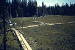
 The gas collectors in the collapsed palsa at NSA-Fen