The BOREAS team successfully completed the first field campaign of 1996. FFC-W (Focused Field Campaign - Winter) was designed to have a focus on the remote sensing of snow in the forest environment and acquire the measurements to help us understand radiative transfer between the forest canopy, the underlying snow-covered ground and the sky radiation field. These data should help us do a much better job of modelling the energy balance of the boreal forest for meteorological forcasts, hydrology, climate models and carbon cycle models.
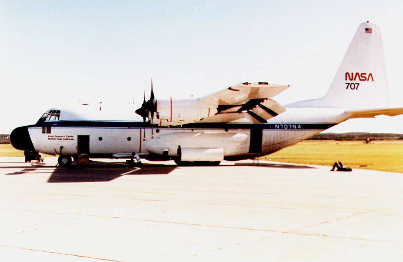
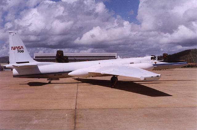
 The campaign started on 2/27/96 and ran through 3/15/96. Two aircraft, the NASA C-130, equipped with the pointable ASAS instrument, and the NASA ER-2, equipped with AVIRIS, were slated to overfly targets inside the southern edge of the Canadian boreal forest. These aircraft were supported by ground teams who made radiometric measurements within and above the forest canopy, and in situ measurements of snow depth and properties.
The whole campaign can only be described as a smashing success in spite of some rough moments. The C-130 succeeded in aquiring multiangle data over all the targets (see the RSS-2 report below) over several flight days, and the ER-2 obtained a complete AVIRIS data set on 3/7/96 (see RSS-18 below). The RSS-1 team used the multiangle PARABOLA instrument to take data over and beneath forest canopies at three sites in the BOREAS Southern Study Area. At these sites, and at a lake and an agricultural site, the HYD-3 team gathered in situ snow characterization data and subcanopy radiation measurements. The three forest sites, the lake and the field made up the suite of primary targets for the C-130 and were also all covered in the ER-2 AVIRIS mapping mission. Fluxes were measured above the frozen lake site by the British HYD-5 team who swore to keep going until the ice melted and their flag slipped beneath the waves.
As a bonus, the `eyeball' aircraft which is normally used for site and weather reconnaisance over BOREAS, was equipped with a CO2 sampling system (see AFM-14). For the unitiated, the team acronyms translate to science groups working in BOREAS, each led by a principal investigator.
The conditions can only be described as a mixture of OK and awful: we had some very clear days, which was great for optical data aquisition, but the winds and temperatures (often -35 degrees C at the surface) made working outside fairly tough. The pipes froze in our cabins (no washing, shaving, etc for a few days - delightful), power cables broke, plastic shattered and the nostril hair problem was solved fast (they died and fell out). However, the winter scenery was spectacular and the cold air conducted sounds with unearthly fidelity. From the 10000' altitude vantage point of the 'eyeball' aircraft, which was used to 'birddog' sky conditions over the sites prior to committing the C-130, it was remarkable to see how the forest makes its own weather. The dark trees absorb the solar radiation, force convection and often generate herds of puffy cumulus clouds (sky-sheep) over the forest. As the airmass moves from the forest onto the snow-covered agriculture , the convection is cut off and the clouds promptly dissipate.
The ASAS instrument was installed in the NASA (Wallops Flight Facility) C-130, over the winter, a remarkable feat in view of a tight schedule interupted by furloughs and snow days. The Wallops team and the GSFC science crew (RSS-2) worked flat out for weeks to get the job done before FFC-W. The new WFF C-130 crew (only 7 of them in all including the two drivers and flight engineer!) were terrific; flexible, hardworking and optimistic.The C-130 and crew were based at Prince Albert, the last 'big' town in Saskatchewan south of the boreal forest boundary. The primary ASAS targets were the tower flux sites erected for BOREAS in 1993, three of which are equipped with cable tramways which run over and under the forest canopy. These sites will be used from april onwards to mount eddy correlation equipment to measure energy, water and CO2 fluxes, as was done during BOREAS-94. The tramways were used by Don Deering and Tom Eck (RSS-1) to take multidirectional radiation measurements in and above the canopy; these data will interlock directly with the ASAS measurements. Another ground team, led by Janet Hardy of CRREL (HYD-3), took in situ snow measurements at the sites for validation. The ER-2 launched from NASA/Ames for an 8-hour mission to aquire a fine AVIRIS scene over the Southern Study Area on 3/7/96. The AVIRIS data will be processed by Rob Green (RSS-8 and JPL) to produce synthetic MODIS bands out to 2.5 microns.
Piers Sellers, Forrest Hall and Jim Irons (all of GSFC, Code 923) served as mission managers for FFC-W in a series of overlapping shifts (time periods, not fashion nightwear). Dave Knapp and Amy Morrell of the BORIS Staff lasted the entire FFC-W as Study Area Managers. As they left, other BOREAS Staff from GSFC were going up to help install the first Tower Flux teams.
Morale in the project is very high, as always, and the team is delighted to be moving ahead with the new years tasks. The sections below include verbatim reports from the teams involved in FFC-W. The final version of the BOREAS-96 plan has also been finished and is on its way out to the teams. The next field campaign (IFC-1) runs 4/2-28/96; IFC-2 runs 7/9-8/9/96 and IFC-3 finishes up the season during 10/02-22/96.
AFM-14: Airborne CO2 Concentrations
(Sellers, Desjardins, Berry, Dow)
We have been using a light, twin-engined aircraft (a PA-34; Seneca I) for site support work since 1994. Up until this year, 'Eyeball' was used for primarily for site and weather recconnaisance; the aircraft would be sent into the study areas ahead of most of the research aircraft to scope out sky conditions prior to committing the (very expensive) main fleet. In FFC-W, Eyeball was again successfully used as a birddog for the C-130 (see the RSS-2 report below) but also took some real data of its own.
The aircraft has been fitted with a nose-mounted tube, a LiCor gas analyzer, and an onboard gas calibration system. Six 3.5 hour flights were made in FFC-W, in which the aircraft took CO2 concentartion measurements along low-level transects and up and down a series of four sounding patterns. The Licor system was put together at short notice by Ray Desjardins and Dave Dow of Agriculture Canada with input and some resources from Joe Berry (Carnegie-Stanford). Amazingly, the system worked first time and kept working throughout six flights. Cockpit temeperatures in the effectively unheated cabin approached -35 degrees C frequently which made for some uncomfortable flying at 12000'.
The data are now being reduced: we hope to use them to check on the results of large-scale GCM-tracer models, see for example Denning et al (1995) in Nature, which indicate a stronger than suspected Carbon sink in the boreal forest. We intend to conduct more flights in the thaw, summer and fall IFC's.
HYD-3: Snowpack Characterization and RT in Forests
(Hardy, Davis, and Woodcock)
Somehow, we northerners managed to thrive in the cold temperatures and less-than-hospitable conditions (partial thanks to the warm huts)! During the first week of the campaign we were based at old black spruce. For 5 days, we ran our radiometer array of 10 pyranometers placed randomly on the snow surface beneath the canopy. The array also included 2 pyrgeometers and 3 thermal radiometers measuring trunk and canopy temperatures. These data will help calibrate the model of radiative transfer through the canopy, so we can better predict snow processes and the timing of snow melt. Also during this week we conducted detailed snow pack characterization at OBS and the Agricultural site. Additionally, we made lots of random measurements of snow depth (n=100) and integrated snow water equivalence among the trees in OBS.
For the second week, we moved our radiometer array to the Old Aspen site to run there for another 5 days (in 1994, this array ran at OJP for 3 clear days). The clear skies during the first 2 weeks were just what we needed. Snow characterization on the ground was coordinated with flights and the PARABOLA which had us working at OA, OJP, and Namekus Lake. We made more measurements of snow depth and integrated snow water equivalence at all the sites.
The high temperatures (+10 C) during the third week changed the snow pack considerably (especially at the snow surface) and required a revisitation to most sites. This weeks flights and PARABOLA measurements had us revisiting OJP, the Ag. site, and a lake site (this time Waskesiu). These snow pits revealed melt water features in the snow pack, such as thin ice layers and vertical flow fingers.
An additional effort during this campaign was to obtain hemispheric photos of the canopy in the vicinity of the OBS radiometer array. This work required a overcast day, which we fortunately squeezed in at the end of the
second week. We also made miscellaneous measurements of canopy closure, stem density, and needle density to help calibrate the radiative transfer model. The success of the campaign is due in part to the excellent support from the OPS center, many who also had the opportunity to assist in the field.
HYD-5: Energy and Moisture Fluxes From Snow and Ice
(Harding et al)
The UK-based team measured heat and water fluxes above a snow covered lake (Namekus) and a forest area (Beartrap Tower) through March 1996. In addition measurements were made of the interaction between the lake and the surrounding forest using a network of wind stations arround the lake and a tethered ballon system on the lake. The lake was also one of the ASAS targets for the NASA C-130.
The flux measurements were similar to the 1994 campaign with the addition of an eddy correlation system below the forest canopy. A similar picture was found with large, upward sensible heat fluxes from the forest and negative, and sometime large, fluxes over the lake. The below canopy measurements will be used to calibrate a two source model to describe forest/snow evaporation and energy balance.
Tethered balloon meaurements were made on 7 days in the period 12 to 22 March. We measured wind, temperature and humidity up to 200 m (sometimes higher if we dare). The measurements show the lake well coupled with the lake with moderate and high wind speeds, but a decoupling at low speeds. Some evidence of a lake breeze was found (as prediced with mesoscale modelling). The network of 3 weather stations on the lake were operated from 7 March and will continue through to April (if the ice doesn't melt!). My thanks to all that helped us on the lake in what were pretty horrible conditions.
RSS-1: Multi-angle PARABOLA Instrument
(Deering et al.)
The RSS-1 team vanquished the instrument-death-seeking deep-freeze perpetrated by Boreas (the Greek god of the north wind) during the Winter Focused Field Campaign. Daily temperatures typically started at near -40 degrees C and warmed up to -15 or -20 deg. C. With such temperatures plastic sheathed wire cabling snaps and many other materials become brittle or functionless, and electronic and mechanical instruments often cease to operate (even battery-less snowmobile engines strain as though trying to burn cold molasses). On-site adaptions enabled the sensitive components of our field remote sensing instrumentation to function under the frigid conditions, including wrapping electronic cables with water pipe heat tape and insulation and erecting a tent on the top of the 30 m towers so that we could bath the computer and other electronic equipment with ceramic heater-warmed air. The RSS-1 FFC-W objective to obtain bidirectional reflectance measurement data sets of the boreal forests with a snow background along the PARABOLA tramways at the treetops for our three key forest canopies in the SSA: Old Black Spruce, Old Aspen and Old Jack Pine sites was a highly successful endeavor in spite of the adversities. The snow conditions captured represent the typical conditions for more than one-third of the year in this region and for almost one-half the year in the more northerly boreal forests. Data sets such as these were not acquired during the 1994 campaigns (or ever). This RSS-1 activity supports the overall BOREAS RSS tasks of acquiring winter radiation and reflectance measurements, and was coordinated with the RSS aircraft campaigns (ASAS/AVIRIS) and ground measurements of snow hydrology. Of special interest is the influence of snow on the albedos of boreal forest canopies. The snow background condition will also allow us to "cleanly" separate the forest canopy from the "contaminating" backgrounds for a unique plant canopy modeling validation.
RSS-2: Advanced Solid State Array Spectroradiometer (ASAS)
(Irons, Russell, et al)
The BOREAS FFC-W represented the first deployment of the Advanced Solid State Array Spectroradiometer (ASAS) aboard the NASA/Wallops Flight Facility C-130Q aircraft. A lot of hard work and a little luck were required to overcome extra-ordinary political and meteorological obstacles to this deployment. The dedication and skill of a number of individuals at Goddard and Wallops resulted in a successful mission in support of the RSS-2 study.
The deployment first required cutting a new hole in the belly of the C-130Q to serve as the ASAS port. The government furloughs and several facility shut downs due to snow storms reeked havoc with the schedule to cut the port, install ASAS for the first time, and test the system in flight. Despite the delays, the C-130Q was able to carry ASAS to Canada only two days after the start of the FFC. The aircraft crew at Wallops, particularly the lead aeronautic engineer, Dave Pierce, and the ASAS instrument engineers, Phil Dabney and Mike Tierney, devoted many extra hours to the installation. Mr. Pierce's wife graciously waited until the day after the C-130 departed to give birth to their first child.
Once in Canada, the severe weather conditions continued to test the mettle of the staff. ASAS broke down during data acquisition flights on Tues., March 05. Phil Dabney worked long, hard hours to trouble-shoot and repair the sensor. By Thursday night, Phil had found and fixed the problem. He and the C-130 crew had the sensor re-installed and ready to go by Fri. morning.
Friday, March 08, dawned crystal clear and the C-130Q took off to collect data. The repaired sensor worked fine, but after the first flight over a site, crew-members noted an oil leak from one of the engines and the aircraft had to land immediately. Upon inspection, they found a ruptured seal on one of the prop-blades. The crew called all over both the U.S. and Canada to find a shop that could repair the prop. They were able to find one nearby in Edmonton and flew there Fri. evening. The crew and shop worked Fri. night and Sat. They had the prop repaired and tested by Sat. evening and flew back Sun. morning ready for a mission. This performance by the aircraft crew was outstanding.
The Wallops crew of six people was a dedicated, hard-working, high-performance group. Their collective attitude was excellent and they were a joy to work with.
Meanwhile, Fri. remained cloudless and clear; one of the best days I have ever encountered for collecting optical remote sensing data. PARABOLA got some great data over the Old Black Spruce site, but ASAS was shut out and its staff rather discouraged.
The discouragement was quickly reversed. Monday, March 11, turned into a good day for remote sensing. ASAS was able to acquire data over four tower sites and two bare snow sites under clear sky conditions, thereby fulfilling the objectives of the deployment. Some intermittent thin cirrus clouds were evident throughout the day but these clouds did not intefere with the observations. Both the repaired sensor and the repaired aircraft performed optimally. The ASAS data promise to be a rich source of information on the directional distribution of solar radiation scattered by bare snow and by forest canopies with a snow-covered understory. The data acquired over the Old Jack Pine site should prove particularly valuable as co-incident data were acquired at that site. The data included snow characterization data acquired by Janet Hardy of CRREL and PARABOLA data acquired by Don Deering and Tom Eck.
Additional ASAS data were acquired the next day, Tuesday, March 12. The weather was not as co-operative, but ASAS did manage to acquire data over one bare snow site and two tower sites during short-lived holes in the clouds. These data represent repeats of the measurments made on Monday.
The ASAS crew looks forward to returning to Canada aboard the C-130Q for the summer campaign. Successfully meeting the challenges presented by the FFC-W created an excellent working relationship between the ASAS staff and the Wallops C-130Q crew.
RSS-14: AVIRIS (Green)
NASA's Airborne Visible/Infrared Imaging Spectrometer (AVIRIS) measured images for the BOREAS FFC-W experiment on the 7th of March 1996. AVIRIS measures the total upwelling spectral radiance from 400 to 2500 nm at 10 nm intervals as images of 11 by up to 800 km with 20 by 20 m spatial resolution. The data are calibrated spectrally, radiometrically and spatially.
Single band quicklook images of the BOREAS FFC-W AVIRIS data can be viewed at:
ftp://ophelia.jpl.nasa.gov/pub/docs/html/flights/960307.html
These spectral data will support investigation of hydrological and Radiation science questions in the Winter Boreal Forest System.
