1. Project/Campaign Overview:
-
Name of Project/Campaign:
- The First ISLSCP (International Satellite Land Surface Climatology Project) Field Experiment (FIFE)
-
Project/Campaign Introduction:
- FIFE was conducted on the Konza Prairie of central Kansas from 1987 through 1989 to improve understanding of carbon and water cycles and to develop and analyze remote-sensing methodologies for observing these processes.
-
Project/Campaign Mission Objectives:
- The general objectives of FIFE were to understand the biophysical processes controlling the fluxes of exchanges of radiation, moisture, and carbon dioxide between the land surface and the atmosphere; to develop and test remote-sensing methodologies for observing these processes at a pixel level; and to understand how to scale the pixel-level information to regional scales commensurate with modeling of global processes.
-
Discipline(s):
- Earth Science
-
Geographic Region(s):
- Konza Prairie Reserve near Manhattan, Kansas, located in the central plains region of the United States of America.
-
Detailed Project/Campaign Description:
- FIFE investigators collected data from 1987 through 1989 at the Konza Prairie Natural Research Area, a prairie grassland that measures 15 km by 15 km and is located south of the Tuttle Reservoir and Kansas River about 10 km from Manhattan, Kansas, U.S.A. The center of the FIFE site is close to 39.05° N, 96.53° W.
Data were collected through monitoring and through intensive field campaigns (IFCs). Monitoring which was performed nearly continuously through 1987, 1988, and 1989, consisted of the acquisition of AVHRR, Landsat, SPOT, and GOES satellite data; continuous acquisition of relevant meteorological data from 16 automated meteorological stations within the site; collection of gravimetric soil moisture surveys, streamflow data, and biometric measurements; and observation of relevant atmospheric optical properties to study the effects of atmospheric conditions on satellite remote-sensing images.
The IFCs had the specific objective of acquiring surface and airborne data in conjunction with the satellite overpasses to study the biophysical and energetic processes over spatial scales from millimeters to kilometers and temporal scales from seconds to an entire season. The IFCs required a large commitment of manpower and resources; thus, their combined duration during 1987 was only 57 days. Each of the IFC periods targeted a critical phase of vegetative development (IFC-1 "greenup," IFC-2 "peak greenness," IFC-3 "dry-down," and IFC-4 "senescence"). Ground measurements were acquired at 32 sites within the Konza Prairie and were complemented by measurements from a number of other sites (e.g., a dense network of 42 rain gauges in a watershed). Sample sites were placed within strata representing the major spatial variation in soil depth, seasonally integrated incident solar radiation, and management practice (e.g., grazing and burning).
In 1987 unusual weather conditions produced very similar conditions during the first three IFCs (wet soils and green vegetation) followed by a totally senescent vegetation cover and dry soil in IFC-4. During 1989 a 20-day (July24-August12) IFC was instituted to obtain the "dry down" missed during the IFC-3.
More information is available on-line at http://daac.ornl.gov/FIFE/FIFE_About.html.
-
FIFE Study Site:
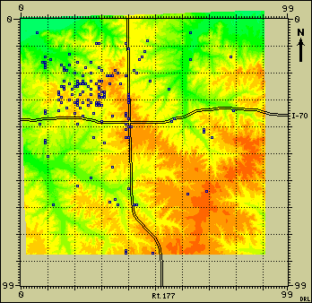
- The FIFE site was a 15 X 15 km area of grassland, most of which is under private
management for grazing. About one-third of the area is managed as a
Long Term Ecological Reserve (LTER) for the study of grassland ecosystem
dynamics. A system of site identifiers was developed to help locate the FIFE data.
A 20 km by 20 km grid was superimposed onto the FIFE area to provide a reference frame
for the site identifiers. Each SITEGRID_ID specifies a node on this grid, thereby
locating the site to within plus or minus 100m in each direction.
The full SITEGRID_ID has the form "SSEE". The four digits of the SITEGRID_ID define the location of the site in terms of the number of nodes south (SS) and east (EE) of the grid origion. Colocated sites share the same SITEGRID_ID. For example, the STATION_ID 902 is replaced by the SITEGRID_ID with location code 1916, where 19 is the number of notes south (SS) from the grid origion, and 16 is the number of notes east (EE) from the grid origion.
The SITEGRID origin (0,0) is located at the upper left corner of the SITEGRID, with the following UTM coordinates:
- SITEGRID Origion Northing = UTM Northing 4,334,000
- SITEGRID Origion Easting = UTM Easting 706,000
These coordinates correspond to the upper left corner of the GIS grid which was used as the template for all of the FIFE GIS imagery. The 20km by 20km grid contains 100 by 100 grid lines (numbered 0 to 99). Northings increase with increasing "Y", and decreasing SITEGRID "SS", where as Eastings increase with increasing "X", and increasing SITEGRID "EE".

-
Ground Measurements:
- Ground measurements were acquired at 32 sites within the Konza and were complemented by a number of other measurement sites (e.g., a dense network of 42 rain gauges in a watershed). A probability sample of sites were placed within strata representing the major spatial variation in soil depth, seasonally integrated incident solar radiation and management practice (e.g. grazing and burning).
-
Science Teams:
- Roughly 100 science investigators and support staff were working at the FIFE site during the IFCs. In addition to the selected investigators working in FIFE, there were two large groups of scientists and support staff conducting measurements on site. One group based at Kansas State University (Staff/KSU) carried out a wide range of measurements for the monitoring program and during IFCs. The Goddard Space Flight Center group (Staff/GSFC) supported experiment design, developed and operated the FIFE Information System (FIS) and provided administrative support.
-
Aircraft Overflights:
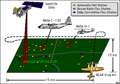
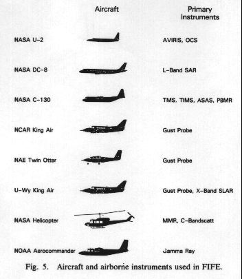
- As part of the experiment, three aircraft (NASA C-130, NASA Helicopter, and NOAA Aerocommander) took radiometric measurements using a variety of scanners, radiometers, and scatterometers operating over the visible, near infrared, thermal, and microwave wavelength intervals. Three other aircraft (Canadian Twin Otter, National Center for Atmospheric Research KingAir, and University of Wyoming KingAir) took flux measurements of heat, moisture, momentum, and carbon dioxide (Twin Otter only) fluxes over the site. These activities were closely coordinated with each other and with satellite overpasses. In all some 180 missions and over 400 flight hours of aircraft flight time were dedicated to data acquisition during FIFE.
-
Scaling Up Analysis (Micro to Macro):
- One of the long-range objectives of FIFE is to make interdisciplinary connections between ground data, aircraft data, and finally satellite data. By making direct comparisons between ground data and corresponding aircraft data, scientists hope to learn about resolving the differences between the two data types. Once these differences -- how to get accurate "ground" data from aircraft overflights -- are understood, scientists can attempt to link aircraft data with satellite data. The eventual goal is to be able to accurately collect "ground" data from satellite overflights. This requires a great deal of new knowledge on how the atmosphere affects measurements and how small-scale trends can be detected within large-scale systems.
Simultaneous Satellite and Aircraft Overflights in FIFE.
Figure showing Aircraft and their Instruments.
2. Data Availability:
Data Type(s):
- Imagery and tabular data.
Input/Output Media:
- Selected data and imagery files are available from the ORNL DAAC Web site (http://daac.ornl.gov). Data can be downloaded through FTP, and they are available on CD-ROM and on diskettes formatted for UNIX, PCs, and Macs.
Proprietary Status:
- The data are free for public use.
3. Data Access:
Data Center Location:
- The Oak Ridge National Laboratory (ORNL) Distributed Active Archive Center (DAAC) is housed within the Environmental Sciences Division at Oak Ridge National Laboratory, which is located in Oak Ridge, Tennessee, U.S.A.
Contact Information:
- ORNL DAAC User Services Office
Oak Ridge National Laboratory
Telephone: +1 (865) 241-3952
Fax: +1 (865) 574-4665
E-mail: ornldaac@ornl.gov Associated Costs:
- The data are are available free of charge.
4. Principal Investigator Information:
5. Submitting Investigator Information:
6. References:
7. Glossary of Terms:
8. List of Acronyms:
- FIFE
- The First ISLSCP (International Satellite Land Surface Climatology Project) Field Experiment
- IFC
- intensive field campaign
- ISLSCP
- International Satellite Land Surface Climatology Project
- URL
- Uniform Resource Locator
A more complete list of acronyms is available at http://cdiac.esd.ornl.gov/cdiac/pns/acronyms.html. For additional terms, see the EOSDIS list of acronyms at http://harp.gsfc.nasa.gov/v0ims/acronyms.html.
9. Document Information:
Document Revision Date:
- March 19, 1999
Document Review Date:
- October 7, 2008
Document ID:
- ORNL-campaign1116
Document Curator:
- webmaster@daac.ornl.gov
Document
- http://daac.ornl.gov/FIFE/fife_campaign.html

