The BOREAS Project was set on the northern and southern edges of the Canadian boreal forest in a 1000 x 1000 km region covering most of Saskatchewan and Manitoba, Canada.

The BOREAS Science Steering Committee conducted the initial study area selection in 1990. This work was followed up by BOREAS staff visits in 1991, 1992 and 1993. The finalized study areas are:
 Each study area covers a domain big enough to allow the acquisition of useful airborne flux measurements and satellite observations but small enough to permit reasonable coverage with surface instruments. It is anticipated that almost all of the land surface climatology, nutrient cycling and tropospheric chemistry process studies (i.e. flux towers and other flux measurement efforts) and most of the remote sensing validation work will be conducted within these areas. Ecological survey and remote sensing studies may also require some sampling within the whole domain along and normal to the growing degree day isolines (roughly corresponding to the productivity gradient) with particular concentration within and around the main sites. The definition and allocation of the auxiliary/process study sites is directed at defining the variability of surface states and processes and associated remote sensing signatures within and between the main sites. The distance between the two study areas is roughly 800 km: this is large enough to resolve the ecological gradient but small enough to permit the ferrying of research aircraft and specialized equipment between sites.Each study area covers a domain big enough to allow the acquisition of useful airborne flux measurements and satellite observations but small enough to conserve a reasonable density of surface instrumentation. Almost all of the land surface climatology, nutrient cycling and tropospheric chemistry process studies (i.e. flux towers and other flux measurement efforts) and most of the remote sensing validation work is being conducted within these areas, see Figure 2. The distance between the two study areas is large enough to resolve the ecological gradient but small enough to permit the ferrying of research aircraft and specialized equipment.
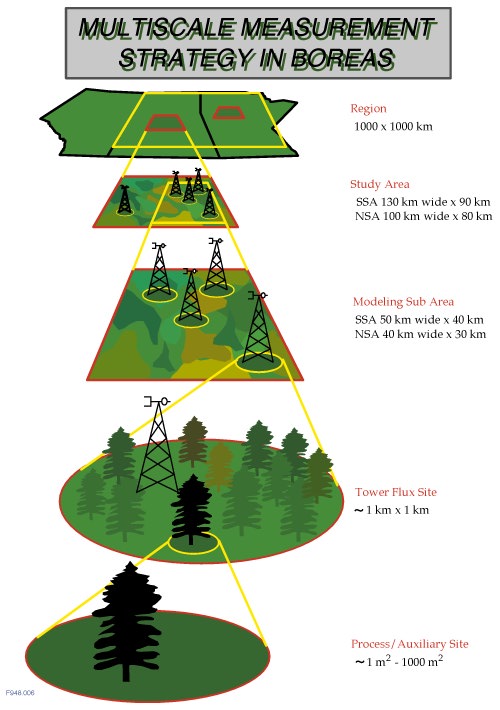
Region: An area of roughly 1000 km by 1000 km covering a large portion of Saskatchewan and Manitoba. This is the domain of meteorological and satellite data acquisition and large-scale modeling.
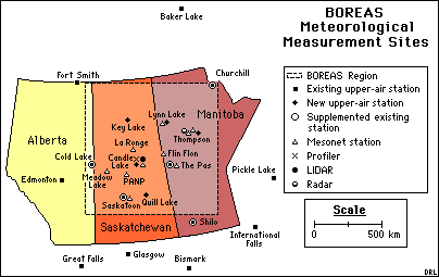
Study Areas: These two areas are embedded within the region and are the focus of satellite and airborne remote sensing studies, airborne flux measurement and mesoscale modeling. The Southern Study Area (11,170 square km) is located north of Prince Albert, Saskatchewan, and the Northern Study Area (8,000 square km) lies west of Thompson, Manitoba.
Transect: This is the area connecting and including the NSA and SSA, running from Thompson, Manitoba to Prince Albert National Park (PANP), Saskatchewan. It is approximately 800 km long. It is mainly flown by aircraft, but there are some ground instruments positioned at meteorological sites along the way.
Modeling Sub-Areas: These are the test areas for modeling activities and gridded data products; They have the highest priority for airborne remote sensing studies and low-level airborne flux measurements. These sub-areas are located within the study areas.
Tower Flux (TF) Sites: These are sites within the study areas where flux measurement towers (TF sites) operate. The TF sites are located in the center of areas of around 1 square km of relatively homogenous vegetation cover, and are expected to measure fluxes representative of these vegetation types. Ten TF sites operated during the field campaigns.
Auxiliary and Process Study Sites: Approximately 80 auxiliary and process study sites, some located within the TF sites, most of the others elsewhere within the study areas, were used for investigator studies or correlative targets for remote sensing investigations. A few of these sites were foci for carbon cycle studies which incorporated measurements of leaf physiology, litterfall and soil CO2 flux. The majority of the sites serve as remote sensing targets and were visited by teams during the field year (1994) who collected a common set of biometric measurements: leaf area index, crown closure, stem area density, etc. These data will be used to improve our ability to interpret satellite and airborne remote sensing data into biophysical and ecological parameters.
