In particular, the staff dealt with the organization of the field logistics (tower construction, tower supplies, etc.) and the day-to-day management of field operations. The staff monitoring program includes:
The NASA staff also are responsible for implementing the BOREAS Information System (BORIS) which will serve as a data organization, distribution and archiving center for the project.
All in all, some 300 people were working within or above the study areas during 1994 and 1996 field seasons.
PI: Stan Shewchuk -- Saskatchewan Research Council (SRC)
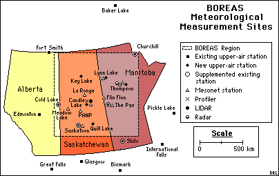
Objectives: Collect continuous fifteen-minute core climate data from ten automated towers located across the BOREAS region. All ten towers measure such parameters as air temperature, soil temperature and moisture, relative humidity, station pressure, wind speed and direction, incoming and reflected shortwave radiation, PAR, net radiation, and precipitation. Five of these towers are supplemented with incoming diffuse shortwave radiation and incoming longwave radiation.
Please see AFM-7 for more information.
PI: Barrie Atkinson -- Environment Canada
Objectives: Capture data from existing Environment Canada meteorology autostations within the BOREAS region at a frequency of 15 minutes.
Get some AES Surface Met data using FTP (BOREAS Investigators only, password required). [FTP Help]
PI: Alan Barr - Atmospheric Environmental Service (AES)
Objectives: Deploy radiosondes from BOREAS locations. Collect, process, and quality check data from these locations and pre-existing sites in the BOREAS region. Sondes were launched from two times up to seven times daily during Intensive Field Campaigns. Soundings have also been interpolated to five millibar levels for a Level-2 data set.
Please see AFM-5 for more information.
PI: BOREAS Staff
Objectives: A gridded surface data set for all of 1994 has been acquired from the European Centre for Medium-Range Weather Forecasts (ECMWF). This data set covers the BOREAS region in a Latitude/Longitude grid at a grid length of 0.5 degrees and is comprised of parameters from the ECMWF/WCRP Level III-A Global Atmospheric Data Archive. Parameters are reported four times daily at six hour intervals. Parameters include surface pressure, mean sea level pressure, wind components, air temperature and dewpoint temperature, surface temperature at three levels, surface wetness at three levels, surface soil wetness, deep soil wetness, deep soil temperature, surface geopotential, land-sea mask, surface roughness, albedo, climatological deep soil wetness, climatological deep soil temperature, snow depth, snowfall, large scale precipitation, convective precipitation, and evaporation. Total precipitation is given daily at 1200 UTC. Data is archived on 8mm Exabyte tape in FM 92-VIII Ext. GRIB format. Similar data sets are planned for 1995 and 1996.
Get some ECMWF Met data using FTP (BOREAS Investigators only, password required). [FTP Help]
PI's: Hugo Veldhuis, Elissa Levine -- NASA/Goddard Space Flight Center
Objectives: The objective of the NSA soil characterization was to provide investigators with a map of soil types in the modeling sub-area and around the towers.
Types of Data Collected:
The map of the NSA modeling sub-area was done at a scale of 1:50,000 while the maps of the tower areas were done at 1:5,000. This characterization also includes information about physiography, surficial deposits, soil moisture regime, and permafrost.
 The types of data collected included aerial photography taken between 1971 and 1978. The field data were used in conjunction with the photos to delineate soil polygons.
Summary of Places and Times of Measurements:
Most of the field data were collected at the NSA tower sites and at various remote locations in the modeling sub-area during the 1994 field campaigns.
Get some NSA soil data using FTP (BOREAS Investigators only, password required). [FTP Help]
PI's: Hugo Veldhuis, Elissa Levine -- NASA/Goddard Space Flight Center
Objectives: The objective of collecting the soils properties data is to provide investigators with detailed data about specific soil properties at the tower sites. This data is important for modeling at the site level.
Summary of Places and Times of Measurements:
Samples of soils at the NSA tower sites were collected and analyzed. TE-1 collected and analyzed soil samples for the same soil properties at the SSA towers.
Types of Data Collected:
The samples were collected at the various soil horizons at about 5 different soil pits per tower site. Field samples were collected and analyzed for particle size, total nitrogen, total organic and inorganic carbon, water pH, CaCl2 pH, extractable acidity, exchange capacity, exchangeable Ca Mg Na and K, field moisture, saturated moisture, and wilting moisture.
Get some NSA soil data using FTP (BOREAS Investigators only, password required). [FTP Help]
Forest Cover: Forest cover data sets were acquired from various Canadian agencies. The forest cover data of the SSA identifies map polygons in terms of softwood/hardwood combinations, year of stand origin, height class, and canopy closure. This data was produced at a scale of 1:12,500. The forest cover data of the NSA includes species, crown closure, and cutting class (age). The NSA data was produced at a scale of 1:15,840. Get forest cover maps using FTP (BOREAS Investigators only, password required). [FTP Help]
DEMs: Digital elevation models (DEMs) of the modeling sub-areas of the NSA and SSA were produced from contours at 1:50000 scale by HYD-8. The contour interval of the original vector data is 25 feet. The contours are gridded at a cell resolution of 100 meters in the UTM projection. BORIS staff reprojected this data to the BOREAS grid projection at a cell size of 30 meters.
A DEM of the BOREAS region was produced by the USGS EROS Data Center. This DEM was produced at a cell resolution of 30 arc seconds. This was reprojected into the BOREAS grid projection with a cell resolution of 1000 meters. Get DEM/DTM maps using FTP (BOREAS Investigators only, password required). [FTP Help]
Soils: Soils map data existed for the SSA at a scale of 1:125,000. This data was gridded by BORIS staff and made available to investigators. This data provided information about the soil names. Ancillary information was also provided that included detailed information about each soil name. However, caveats about inferring too much from this data are included.
Soils data for the entire BOREAS region was also available from Canadian government agencies. This soils data was mapped at the provincial scale. These data sets were combined for Saskatchewan and Manitoba, converted to the BOREAS grid projection, and gridded to a cell size of 1000 meters. Unfortunately, because of differences in the mapping between the 2 provinces, there is a polygonal discontinuity along the border. Get soil maps using FTP (BOREAS Investigators only, password required). [FTP Help]
Objectives: The objective of collecting GPS locations was to get precise locations for the sites to compare ground measurements to the satellite and aircraft imagery.
Summary of Places and Times of Measurements:
The auxiliary and tower sites as well as other special sites were located with GPS in the NSA and SSA. Darcy Snell collected the GPS data during the 1994 field campaigns.
Types of Data Collected:
A wide area correction technique was used that allowed determination of locations to +/- 5 meters without using a base station. A six channel Trimble Pathfinder Basic Plus rover unit was used.
Known Problems and Caveats:
Snell duplicated many of the locations that he collected. His locations were found to be consistent within a few meters. His GPS work helped us to discover some large location errors in the 1:50,000 scale NTS maps of the NSA. The maps of the SSA were found to be accurate to within about 60 meters.
As a result of finding errors in the maps of the NSA, GPS locations of some selected road intersections were collected for BOREAS by the Geodetic Survey of Canada. These locations were used to geotag the satellite imagery of the NSA.
On-site Radiometric and Spectral Calibration sources
A 76 cm hemispherical integrating source was maintained on site at the active airport (Prince Albert or Thompson) during the IFC's. This source was radiometrically calibrated at GSFC prior to deployment and recalibrated during IFC-2 on site at Thompson. Calibration radiances of the source were provided to users of the calibration source. ASAS, CASI, the helicopter SE590 and MMR and the Exotech on the Twin Otter all viewed the hemisphere during the campaign, most at least once per IFC. An extended area blackbody source was also available on site and was used at least once for calibration of the PRT-5 on the Twin Otter.
Diffuse Reflectance Reference Panels
The University of Nebraska characterized the reflectance of calibration panels used by investigators measuring surface reflectance prior to the start of the BOREAS field season.
In-Flight Calibration and Comparison of Aircraft Instrumentation
A ground reference calibration site was set up and maintained by RSS-19 near the airport in the SSA during IFC's 1 and 3. The surface reflectance of this site was characterized in the 400 to 2500 nm spectral region to provide a calibration of the various ground looking reflective sensors.
Staff: Betsy Middleton, Michele Ernst, Lori Leeder
During the 1994 Field Campaigns, BOREAS provided two sets of 12 calibration cylinders for each laboratory (Paddockwood and Thompson). Each 12 cylinder set was comprised of: 1 each methane in air (0.5, 0.8, 2 and 9 ppmv), 2 each CO2 in air (300, 355, and 400 ppmv), and 1 each CO2 in air (700 and 2000 ppmv). In addition, two IRGAs (LI-COR 3200) were loaned to the labs for use with the calibration standards. In 1994, CCRS (Gill Traynor and Jing Chen) arranged a bulk order of working standards to the field labs. All of these were collected by Medigas/PRAXAIR in late September 1994.
E-Mail a comment on this page to the curator 
Return to the BOREAS Science Groups Overview
Return to the BOREAS Home Page
Last Updated: October 29, 1997