Get Data
Summary:
This data set consists of a 1:2 million scale forest cover map for the land area of the Krasnoyarsk Region, Russia. Thirty-two land cover classes are distinguished. These data were digitized from maps of the Atlas of Forests of the USSR (Anon. 1973). This map should be viewed not as a map of actual forest cover but rather as a map of dominant tree species. Very few tree species are defined, and generally, each polygon and color has only one tree species assigned to it.
Unlike other data sets associated with this project, this data set is available only in ArcView shapefile format (vector). A graphic map is also available in JPEG format (see Figure 1). Please read all documentation before using these files.
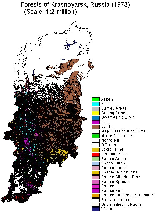
Figure 1. Forest Cover Map for the Land Area of the Krasnoyarsk Region, Russia
Data Citation:
Cite this data set as follows:
Stone, T. A., P. Schlesinger, and V. A. Alexeyev. 2003. RLC Forest Cover of the Krasnoyarsk Region, Russia, 1973. Data set. Available on-line [http://www.daac.ornl.gov] from Oak Ridge National Laboratory Distributed Active Archive Center, Oak Ridge, Tennessee, U.S.A. doi:10.3334/ORNLDAAC/693.
Table of Contents:
- 1 Data Set Overview
- 2 Data Characteristics
- 3 Applications and Derivation
- 4 Quality Assessment
- 5 Acquisition Materials and Methods
- 6 Data Description and Access
- 7 References
- 8 Glossary and Acronyms
- 9 Document Information
1. Data Set Overview:
Data Set Contents:
This data set consists of a 1:2 million scale land cover map for the land area of the Krasnoyarsk Region, Russia.
Related Data Sets:
See other Russian Land Cover data sets.
Title of Investigation:
Measuring Changes to Russian Forest Over the Last 25 Years
Investigator(s) Name and E-mail:
| Name | |
|---|---|
| Stone, T. A. | tstone@whrc.org |
| Schlesinger, P. | pschles@whrc.org |
| Alexeyev, Vlady A. | alexeyev@rcom.mail.ru |
Technical Contact(s) Name, Telephone, and E-mail:
Variable Description Units Instrument Range Forest Cover Classes Forest cover classes defined in footnote. unitless Atlas of Forests of the USSR (1973) 0 - 115
Forest Cover Classes footnote:
CODE CLASS 0 Unclassified Polygons 1 Scotch Pine 2 Spruce 3 Fir 4 Spruce-Fir 5 Larch 6 Siberian Pine 13 Birch 14 Aspen 15 Nonforest 16 Water 17 Sparse Scotch Pine 19 Sparse Spruce 21 Sparse Larch 22 Sparse Siberian Pine 24 Sparse Birch 26 Sparse Aspen 27 Burned Areas 28 Cutting Areas 29 Off Map 30 Stony, nonforest 33 Mixed Deciduous 38 Map Classification Error 39 Nonforest 40 Sparse Scotch Pine 41 Map Classification Error 98 Spruce-Fir, Spruce Dominant 99 Dwarf Arctic Birch 100 Off Map 115 Nonforest Future Modifications and Plans:
Not available
2. Data Characteristics:
Study Area:
Spatial Coverage:
Min. X: -1144310
Max. X: 1636312
Min. Y: -453218
Max. Y: 2354392
In meters from 104.5 degrees E, 56.5 degrees NSpatial Resolution:
1:2,000,000
Projection:
Lambert Azimuthal Equal Area
Grid Description:
Not applicable
Temporal Coverage:
Not applicable
Parameter or Variable:
Data Organization:
Please read all companion documentation before using these files: http://daac.ornl.gov/daacdata/russian_land_cover/forest_map_krasnoyarsk/comp/fmap73_kr_readme.txt and http://daac.ornl.gov/daacdata/russian_land_cover/forest_map_krasnoyarsk/comp/fmap73_kr_projection.txt.
Granule Name or Description:
fmap73_kr.zip
Data Format:
Vector map of forest polygons in the Krasnoyarsk Region (1973). Data are in ArcView shapefile format (compressed).
Sample Data Record:
Not applicable.
3. Application and Derivation:
Typical Application of Data:
Regional-, national-, and sub-national-level forest and land use change assessments
Theory of Measurements:
Not available
Derivation Techniques and Algorithms:
Formulae:
Not available
Processing Steps:
This data set was derived from six source map sheets. Each sheet size is slightly different from the others because each is on a different page in the Atlas of Forests of the USSR (1973). All of the polygons on the map sheets were digitized, edited, and labeled using the Rootspro(c) Digitizing System. Each map sheet was imported into ArcInfo for UNIX, where it was transformed to real world coordinates using Digital Chart of the World (DCW) and World Vector Shoreline (WVS) vectors for control. Each of the map sheet coverages was reprojected from Equi-Distant Conic projection to Lambert Azimuthal Equal Area projection using ArcInfo's PROJECT command and the parameters below (See Processing Changes). Accurate mosaiking of the map sheets within ArcInfo proved to be less than satisfactory. None of the map sheets had embedded real world coordinates, and fifty control points were used in each case. The subsequent vector coverages was converted into ArcView shapefile format.
Processing Changes:
Datum : Undefined
Delta WGS84 : 0 0 0
Ellipsoid : Sphere
Radius of sphere: 6370997.0000
Origin long : 104.5
Origin lat : 56.5
false Easting: 0.0
False Northing: 0.0 metersSpecial corrections/Adjustments:
Not applicable
Calculated Variables:
Not applicable
Graphs and Plots Used in Analysis:
Not applicable
4. Quality Assessment:
Data Usage Guidance:
Errors and Limitations:
Error Sources:
Not Available
Limitations of the Data:
This map should not be viewed as a map of actual forest cover. It should be viewed as as a map of dominant tree species. Very few tree species are defined, and generally, each polygon and color has only one tree species assigned to it. As in other maps, the polygons are discreet entities, tree species categories do not blend into one another. In nature, vegetation types and forms tend to go through gradual transitions from one group of plant species to another. This gradual transition is lost in cartographic products when a line is drawn that separates two units of land cover. Maps that are produced from satellite data are generally raster products that do not define well-bounded polygons and, in a sense, may be more representative of nature.
Known Problems with the Data:
Not Available
Quality Assessment Activities:
Not available
Other Relevant Information about the Study:
Not available
5. Acquisition Materials and Methods:
Source or Platform Collection Environment:
Not available
Source or Platform Program Management:
Not available
Source or Platform Mission Objectives:
Coverage Information:
Not available
Attitude Characteristics:
Not available
Data Collection System:
Not available
Communication Links:
Not available
List of Sensors or Instruments:
Analysis
Ground Segment Information:
Data Acquisition and Processing:
Not available
Latitude Crossing Times:
Not available
Sensor or Instrument Descriptions
Key Variables:
Not available
Principles of Operation:
Not available
Sensor or Instrument Measurement Geometry:
Not available
Manufacturer of Sensor or Instrument:
Not available
Calibration:
Specifications:
Not applicable
Tolerance:
Not applicable
Frequency of Calibration:
Not applicable
Other Calibration Information:
Not applicable
Data Acquisition Methods:
These data were digitized from maps of the Atlas of Forests of the USSR (1973).
Observations
Data Notes:
Not Available
6. Data Description and Access:
Data Access:
This data set is available from the Oak Ridge National Laboratory (ORNL) Distributed Active Archive Center (DAAC).
Data Archive Center:
Contact for Data Center Access Information:
E-mail: uso@daac.ornl.gov
Telephone: +1 (865) 241-3952
FAX: +1 (865) 574-4665
Product Availability:
Data can be accessed electronically on the ORNL DAAC's anonymous HTTP site or from the DAAC's search and order system. Data files are also available by request from uso@daac.ornl.gov.
Reading the Media:
Not applicable
Software and Analyses Tools:
Not applicable
7. References:
The published reference for the source data is as follows:
Anon. 1973. Atlas of Forests for the Soviet Union, Main Geodetic and Cartographic Organization for the Ministries of the USSR, Moscow, 222 pp.
8. Glossary and Acronyms:
Glossary:
Not available
Acronyms:
Acronym Definition ASCII American Standard Code for Information Interchange DCW Digital Chart of the World JPEG Joint Photographic Experts Group RMS Root Mean Square WVS World Vector Shoreline 9. Document Information:
2003/11/26
Document Review Date:
2003/11/26
Document Curator:
webmaster@www.daac.ornl.gov
Document URL:
http://daac.ornl.gov